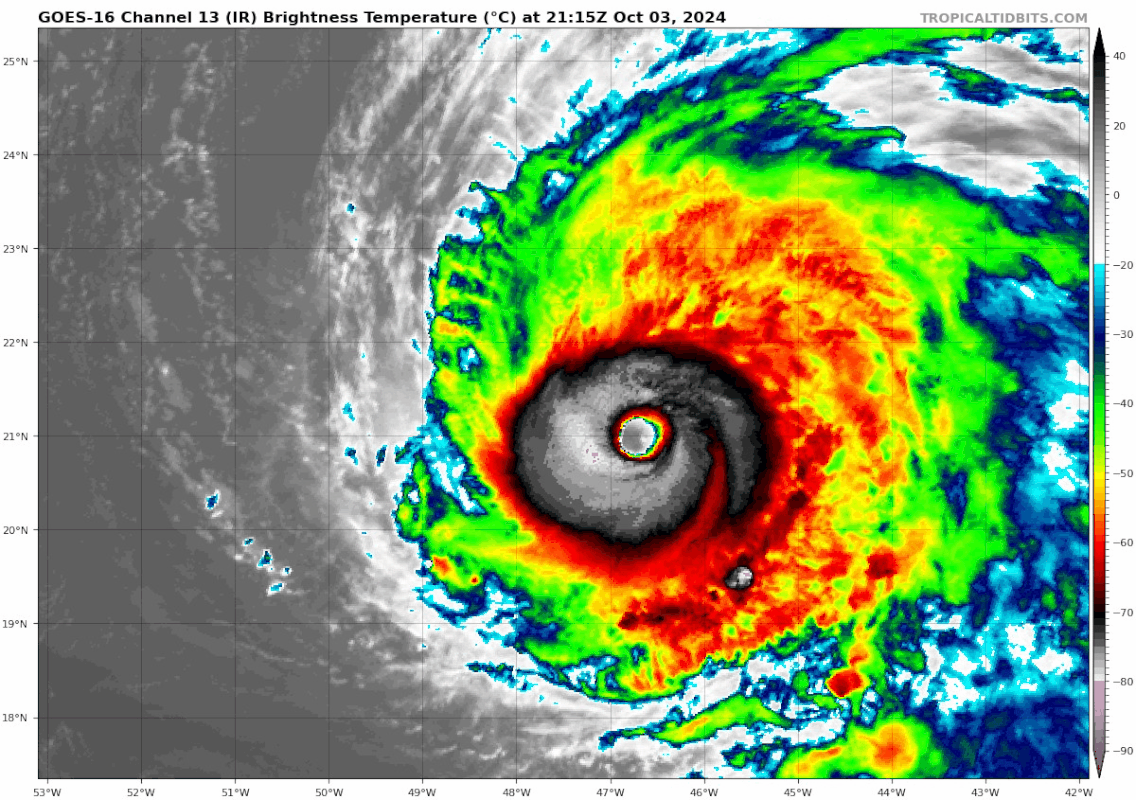
ATL: KIRK - Post-Tropical - Discussion

Moderator: S2k Moderators

Message
Author
User avatar
cheezyWXguy
Category 5
Category 5
Posts: 6091
Joined: Mon Feb 13, 2006 12:29 am
Location: Dallas, TX

Re: ATL: KIRK - Hurricane - Discussion

#301 Postby cheezyWXguy » Thu Oct 03, 2024 8:49 pm

sasha_B wrote:
cheezyWXguy wrote:
PDKlikatino wrote:Between Kirk, Leslie, Gilma, and plenty of other storms this season, it seems like NHC is not on top of things in terms of measuring the intensity. I'm fairly certain that it was mentioned that the NHC isn't going to use SFMR measurements for the remainder of the season but surely there's something going on. Does anyone have any theories as to what might be the case, because I'm stumped.

Planes from the 1970s? Degraded equipment? Radar holes? Could it be insufficient allocation of funds? No, no, conspiracy is afoot.


I mean, I don't think anyone's trying to imply conspiracy. But it does seem to be the case that the NHC has been unusually conservative about making certain calls on several occasions in both the Atlantic and the Pacific this season. More transparency with regard to why they treat certain intensity estimates from (for example, or from recon) as suspect/inadequate evidence would perhaps clarify things for those who are confused or doubtful. They're experts & surely have their reasons for making these decisions - but considering the (apparent) discrepencies between their standards this year compared to years past I don't think it's all that 'conspiratorial' to wonder whether there mightn't have been some changes to policy in addition to issues with equipment, funding, &c - it's a subject that's been raised quite a few times by various commentators here and elsewhere over the past few months.

I agree with your logic and that I would like to see more reasoning behind the conservative estimates that have been given this season on various storms, and I hope we get it with the post season analyses. If we don’t, I think that would be something to call out.

But they aren’t being unusually conservative, they’re being usually conservative. We’ve seen many storms over the years both exceed satellite estimates (Dorian) and fall short of them (Eta) when recon went in, so handling storms without recon is a lot more subject to interpretation. I don’t think it’s bad that we debate the intensity of a storm like Kirk, or debate whether the NHC’s approach is the best, but I don’t think it’s productive to suggest there must be some hidden motive for it and that’s the impression I got from reading the original post.
1 likes   

User avatar
aspen
Category 5
Category 5
Posts: 8812
Joined: Sat Oct 12, 2019 7:10 pm
Location: Connecticut, USA

Re: ATL: KIRK - Hurricane - Discussion

#302 Postby aspen » Thu Oct 03, 2024 8:50 pm


High probability that an EWRC will have started by the time the 5am advisory rolls around. Unless they go a lot higher than the 125 kt BT for 11pm, the only shot this had at an upgrade was an intermediate special update, like they did for Kirk’s Cat 3 upgrade.

This is literally just a repeat of Typhoon Bualoi, which was operationally assessed at 125 kt despite satellite support for a Cat 5 (it later got a massive post-season upgrade). Similar presentation and trajectory too.
3 likes   
Irene '11 Sandy '12 Hermine '16 5/15/2018 Derecho Fay '20 Isaias '20 Elsa '21 Henri '21 Ida '21

I am only a meteorology enthusiast who knows a decent amount about tropical cyclones. Look to the professional mets, the NHC, or your local weather office for the best information.

User avatar
Teban54
Category 5
Category 5
Posts: 3168
Joined: Sat May 19, 2018 1:19 pm

Re: ATL: KIRK - Hurricane - Discussion

#303 Postby Teban54 » Thu Oct 03, 2024 9:00 pm

aspen wrote:

High probability that an EWRC will have started by the time the 5am advisory rolls around. Unless they go a lot higher than the 125 kt BT for 11pm, the only shot this had at an upgrade was an intermediate special update, like they did for Kirk’s Cat 3 upgrade.

This is literally just a repeat of Typhoon Bualoi, which was operationally assessed at 125 kt despite satellite support for a Cat 5 (it later got a massive post-season upgrade). Similar presentation and trajectory too.

I suppose another possibility is that they may mention in the discussion that Kirk likely peaked at XXX kt at XXz. They did this for Sam at its peak, when an EWRC started soon after the previous advisory, and recon only came in after EWRC commenced:
Hurricane Sam Discussion Number 18
NWS National Hurricane Center Miami FL AL182021
1100 PM AST Sun Sep 26 2021

A NOAA Hurricane Hunter aircraft investigating Sam this afternoon
and evening found that the major hurricane likely peaked in
intensity at around 135 kt with a central pressure of about 929 mb
between 1900-2200 UTC when the eye contracted down to about 7 nmi in
diameter.

However, while a 130-135 kt upgrade in this manner may be possible (since the CI 7.0 happened after 0z best track), getting 140 kt this way seems very unlikely operationally. We all know NHC has been very careful with Cat 5 upgrades historically, even for those that got it: Jose, Michael (took until TCR), Dorian (there were unofficial calls for Cat 5 until it strengthened further to erase any doubts), Iota, Sam, Ian (also took until TCR, though most people didn't expect an upgrade beforehand). In fact, Lorenzo seems to be the exception, not the rule.
5 likes   

CrazyC83
Professional-Met
Professional-Met
Posts: 34001
Joined: Tue Mar 07, 2006 11:57 pm
Location: Deep South, for the first time!

Re: ATL: KIRK - Hurricane - Discussion

#304 Postby CrazyC83 » Thu Oct 03, 2024 9:05 pm

SAB has T6.5 right now, which the NHC must be leaning towards.

That said, I'd put more faith in the ADT and go with 135 kt (pressure 924 mb).

TXNT23 KNES 040032
TCSNTL

A. 12L (KIRK)

B. 04/0000Z

C. 21.1N

D. 47.1W

E. ONE/GOES-E

F. T6.5/6.5

G. IR/EIR/SWIR

H. REMARKS...A WMG EYE SURROUNDED BY W THAT IS EMBEDDED WITHIN B RESULTS
IN AN ENO OF 5.5 AND AN EADJ OF +1.0 GIVING A DT OF 6.5. THE MET IS 6.5
BASED ON A REGULARLY DEVELOPING TREND IN APPARENT INTENSITY OVER THE
PAST 24 HOURS. THE PT IS ALSO 6.5. THE FT IS BASED ON THE DT.

I. ADDL POSITIONS

NIL


...HOSLEY
2 likes   

CrazyC83
Professional-Met
Professional-Met
Posts: 34001
Joined: Tue Mar 07, 2006 11:57 pm
Location: Deep South, for the first time!

Re: ATL: KIRK - Hurricane - Discussion

#305 Postby CrazyC83 » Thu Oct 03, 2024 9:17 pm

cheezyWXguy wrote:
sasha_B wrote:
cheezyWXguy wrote:Planes from the 1970s? Degraded equipment? Radar holes? Could it be insufficient allocation of funds? No, no, conspiracy is afoot.


I mean, I don't think anyone's trying to imply conspiracy. But it does seem to be the case that the NHC has been unusually conservative about making certain calls on several occasions in both the Atlantic and the Pacific this season. More transparency with regard to why they treat certain intensity estimates from (for example, or from recon) as suspect/inadequate evidence would perhaps clarify things for those who are confused or doubtful. They're experts & surely have their reasons for making these decisions - but considering the (apparent) discrepencies between their standards this year compared to years past I don't think it's all that 'conspiratorial' to wonder whether there mightn't have been some changes to policy in addition to issues with equipment, funding, &c - it's a subject that's been raised quite a few times by various commentators here and elsewhere over the past few months.

I agree with your logic and that I would like to see more reasoning behind the conservative estimates that have been given this season on various storms, and I hope we get it with the post season analyses. If we don’t, I think that would be something to call out.

But they aren’t being unusually conservative, they’re being usually conservative. We’ve seen many storms over the years both exceed satellite estimates (Dorian) and fall short of them (Eta) when recon went in, so handling storms without recon is a lot more subject to interpretation. I don’t think it’s bad that we debate the intensity of a storm like Kirk, or debate whether the NHC’s approach is the best, but I don’t think it’s productive to suggest there must be some hidden motive for it and that’s the impression I got from reading the original post.


It's very difficult to figure out storms without Recon and a lot of subjective analysis is involved, plus the uncertainty is +/- 10 to 15 knots, instead of +/- 5 knots or so. Still, to get a cat 5 without Recon usually requires *consensus* T7.0, or an averaged out value there with one analysis closer to T7.5 even if others fall below.
4 likes   

User avatar
InfernoFlameCat
Category 5
Category 5
Posts: 2102
Age: 22
Joined: Mon Dec 14, 2020 10:52 am
Location: Buford, GA

Re: ATL: KIRK - Hurricane - Discussion

#306 Postby InfernoFlameCat » Thu Oct 03, 2024 9:22 pm

Such a beautiful storm. I cannot wait to see what it will look like in the morning, barring an EWRC of course.
3 likes   
I am by no means a professional. DO NOT look at my forecasts for official information or make decisions based on what I post.

Goal: to become a registered expert over tropical and subtropical cyclones.

User avatar
Teban54
Category 5
Category 5
Posts: 3168
Joined: Sat May 19, 2018 1:19 pm

Re: ATL: KIRK - Hurricane - Discussion

#307 Postby Teban54 » Thu Oct 03, 2024 9:25 pm

Image
4 likes   

Sciencerocks
Category 5
Category 5
Posts: 8903
Age: 39
Joined: Thu Jul 06, 2017 1:51 am

Re: ATL: KIRK - Hurricane - Discussion

#308 Postby Sciencerocks » Thu Oct 03, 2024 9:27 pm

Image
0 likes   

User avatar
Travorum
Category 1
Category 1
Posts: 406
Joined: Tue Sep 05, 2023 9:36 am
Location: Dunedin, FL

Re: ATL: KIRK - Hurricane - Discussion

#309 Postby Travorum » Thu Oct 03, 2024 9:36 pm

Kept at 125kt for 11pm, based on a blend of estimates from 115kt to 135kt. I might be forgetting something but I cannot recall a recent (post 5pm) satellite estimate that pegged Kirk at 115kt, so IDK what they're referencing there.
Kirk continues to prosper. The earlier eyewall replacement cycle
appears to have completed, and Kirk is back on a strengthening
trend. Satellite images indicate that Kirk has a circular and
clear 15 n mi eye surrounded by a solid ring of intense deep
convection. The latest satellite intensity estimates range from
115 to 135 kt, and based on that data, the initial wind speed is
increased to 125 kt.


Now forecast to peak at 135kt in 12 hours, although most hurricane models put the peak a little further at 24-36 hours from now
FORECAST POSITIONS AND MAX WINDS

INIT 04/0300Z 21.5N 47.5W 125 KT 145 MPH
12H 04/1200Z 22.5N 48.6W 135 KT 155 MPH
24H 05/0000Z 24.4N 49.7W 130 KT 150 MPH
36H 05/1200Z 26.8N 50.3W 120 KT 140 MPH
48H 06/0000Z 30.0N 49.9W 110 KT 125 MPH
60H 06/1200Z 33.6N 48.3W 100 KT 115 MPH
72H 07/0000Z 37.3N 44.7W 90 KT 105 MPH
96H 08/0000Z 43.5N 33.2W 75 KT 85 MPH
120H 09/0000Z 47.0N 16.8W 60 KT 70 MPH...POST-TROP/EXTRATROP
Last edited by Travorum on Thu Oct 03, 2024 9:38 pm, edited 1 time in total.
2 likes   

zzzh
Category 3
Category 3
Posts: 833
Joined: Thu Sep 02, 2021 1:13 pm

Re: ATL: KIRK - Hurricane - Discussion

#310 Postby zzzh » Thu Oct 03, 2024 9:37 pm

Kirk continues to prosper. The earlier eyewall replacement cycle
appears to have completed, and Kirk is back on a strengthening
trend. Satellite images indicate that Kirk has a circular and
clear 15 n mi eye surrounded by a solid ring of intense deep
convection. The latest satellite intensity estimates range from
115 to 135 kt, and based on that data, the initial wind speed is
increased to 125 kt.

Really confusing discussion. Has ERC ever happened? Why they say it's completed when they didn't mention it at all in the last advisory? What satellite estimate gives 115kt? Is it reliable?
3 likes   

User avatar
Kingarabian
S2K Supporter
S2K Supporter
Posts: 15827
Joined: Sat Aug 08, 2009 3:06 am
Location: Honolulu, Hawaii

Re: ATL: KIRK - Hurricane - Discussion

#311 Postby Kingarabian » Thu Oct 03, 2024 9:39 pm

CrazyC83 wrote:SAB has T6.5 right now, which the NHC must be leaning towards.

That said, I'd put more faith in the ADT and go with 135 kt (pressure 924 mb).

TXNT23 KNES 040032
TCSNTL

A. 12L (KIRK)

B. 04/0000Z

C. 21.1N

D. 47.1W

E. ONE/GOES-E

F. T6.5/6.5

G. IR/EIR/SWIR

H. REMARKS...A WMG EYE SURROUNDED BY W THAT IS EMBEDDED WITHIN B RESULTS
IN AN ENO OF 5.5 AND AN EADJ OF +1.0 GIVING A DT OF 6.5. THE MET IS 6.5
BASED ON A REGULARLY DEVELOPING TREND IN APPARENT INTENSITY OVER THE
PAST 24 HOURS. THE PT IS ALSO 6.5. THE FT IS BASED ON THE DT.

I. ADDL POSITIONS

NIL


...HOSLEY


Not sure about the embedded in B stuff by SAB. This was a very easy 7.0. E-Number + Eye Adjustment. Eye embedded in W. So that's a 6.0. Then we can do an eye adjustment of +1.0 because it's clearly WMG embedded in W. Which would be 7.0. Which is what ADT is seeing.
3 likes   
RIP Kobe Bryant

User avatar
Teban54
Category 5
Category 5
Posts: 3168
Joined: Sat May 19, 2018 1:19 pm

Re: ATL: KIRK - Hurricane - Discussion

#312 Postby Teban54 » Thu Oct 03, 2024 9:46 pm

Travorum wrote:Kept at 125kt for 11pm, based on a blend of estimates from 115kt to 135kt. I might be forgetting something but I cannot recall a recent (post 5pm) satellite estimate that pegged Kirk at 115kt, so IDK what they're referencing there.
Kirk continues to prosper. The earlier eyewall replacement cycle
appears to have completed, and Kirk is back on a strengthening
trend. Satellite images indicate that Kirk has a circular and
clear 15 n mi eye surrounded by a solid ring of intense deep
convection. The latest satellite intensity estimates range from
115 to 135 kt, and based on that data, the initial wind speed is
increased to 125 kt.


Now forecast to peak at 135kt in 12 hours, although most hurricane models put the peak a little further at 24-36 hours from now
FORECAST POSITIONS AND MAX WINDS

INIT 04/0300Z 21.5N 47.5W 125 KT 145 MPH
12H 04/1200Z 22.5N 48.6W 135 KT 155 MPH
24H 05/0000Z 24.4N 49.7W 130 KT 150 MPH
36H 05/1200Z 26.8N 50.3W 120 KT 140 MPH
48H 06/0000Z 30.0N 49.9W 110 KT 125 MPH
60H 06/1200Z 33.6N 48.3W 100 KT 115 MPH
72H 07/0000Z 37.3N 44.7W 90 KT 105 MPH
96H 08/0000Z 43.5N 33.2W 75 KT 85 MPH
120H 09/0000Z 47.0N 16.8W 60 KT 70 MPH...POST-TROP/EXTRATROP

I honestly have no idea how any of this makes sense.

But at least the bright side is that, now that they have put 135 kt on the official forecast, perhaps they would be willing to pull the trigger to 140 kt if satellite estimates keep up -- or rather, if satellite estimates actually work as intended and are given proper attention.
1 likes   

zzzh
Category 3
Category 3
Posts: 833
Joined: Thu Sep 02, 2021 1:13 pm

Re: ATL: KIRK - Hurricane - Discussion

#313 Postby zzzh » Thu Oct 03, 2024 9:48 pm

Teban54 wrote:
Travorum wrote:Kept at 125kt for 11pm, based on a blend of estimates from 115kt to 135kt. I might be forgetting something but I cannot recall a recent (post 5pm) satellite estimate that pegged Kirk at 115kt, so IDK what they're referencing there.
Kirk continues to prosper. The earlier eyewall replacement cycle
appears to have completed, and Kirk is back on a strengthening
trend. Satellite images indicate that Kirk has a circular and
clear 15 n mi eye surrounded by a solid ring of intense deep
convection. The latest satellite intensity estimates range from
115 to 135 kt, and based on that data, the initial wind speed is
increased to 125 kt.


Now forecast to peak at 135kt in 12 hours, although most hurricane models put the peak a little further at 24-36 hours from now
FORECAST POSITIONS AND MAX WINDS

INIT 04/0300Z 21.5N 47.5W 125 KT 145 MPH
12H 04/1200Z 22.5N 48.6W 135 KT 155 MPH
24H 05/0000Z 24.4N 49.7W 130 KT 150 MPH
36H 05/1200Z 26.8N 50.3W 120 KT 140 MPH
48H 06/0000Z 30.0N 49.9W 110 KT 125 MPH
60H 06/1200Z 33.6N 48.3W 100 KT 115 MPH
72H 07/0000Z 37.3N 44.7W 90 KT 105 MPH
96H 08/0000Z 43.5N 33.2W 75 KT 85 MPH
120H 09/0000Z 47.0N 16.8W 60 KT 70 MPH...POST-TROP/EXTRATROP

I honestly have no idea how any of this makes sense.

But at least the bright side is that, now that they have put 135 kt on the official forecast, perhaps they would be willing to pull the trigger to 140 kt if satellite estimates keep up -- or rather, if satellite estimates actually work as intended and are given proper attention.

Image
it doesn't have more time.
0 likes   

User avatar
Hypercane_Kyle
Category 5
Category 5
Posts: 3344
Joined: Sat Mar 07, 2015 7:58 pm
Location: Cape Canaveral, FL

Re: ATL: KIRK - Hurricane - Discussion

#314 Postby Hypercane_Kyle » Thu Oct 03, 2024 9:49 pm

The Star Trek reference in the first paragraph, lol. You know they were just waiting for that.
3 likes   
My posts are my own personal opinion, defer to the National Hurricane Center (NHC) and other NOAA products for decision making during hurricane season.

User avatar
Travorum
Category 1
Category 1
Posts: 406
Joined: Tue Sep 05, 2023 9:36 am
Location: Dunedin, FL

Re: ATL: KIRK - Hurricane - Discussion

#315 Postby Travorum » Thu Oct 03, 2024 9:49 pm

zzzh wrote:
Kirk continues to prosper. The earlier eyewall replacement cycle
appears to have completed, and Kirk is back on a strengthening
trend. Satellite images indicate that Kirk has a circular and
clear 15 n mi eye surrounded by a solid ring of intense deep
convection. The latest satellite intensity estimates range from
115 to 135 kt, and based on that data, the initial wind speed is
increased to 125 kt.

Really confusing discussion. Has ERC ever happened? Why they say it's completed when they didn't mention it at all in the last advisory? What satellite estimate gives 115kt? Is it reliable?


Yeah, the latest 115kt ADT CI# was at 12:40z, over 15 hours ago. The latest TAFB or SAB subjective estimate at or below 115kt was 18:00z, over 9 hours ago. If a recent 115kt satellite intensity estimate exists, its not one the public is privy to.

In my uneducated opinion and only relying on present intensity estimates, the 00z T6.5 SAB estimate combined with a peak T7.0 ADT estimate would blend to 135kt, or 130kt if you go very conservative.
Last edited by Travorum on Thu Oct 03, 2024 9:58 pm, edited 1 time in total.
3 likes   

User avatar
WaveBreaking
Category 2
Category 2
Posts: 562
Joined: Sun Jun 30, 2024 11:33 am
Location: US

Re: ATL: KIRK - Hurricane - Discussion

#316 Postby WaveBreaking » Thu Oct 03, 2024 9:55 pm

IR Image of Kirk from the new GOES-19 satellite. Preliminary imagery from this satellite is available here: https://rammb-slider.cira.colostate.edu ... aw_width=6


Image
3 likes   
I am NOT a professional meteorologist, so take all of my posts with a grain of salt. My opinions are mine and mine alone.

CrazyC83
Professional-Met
Professional-Met
Posts: 34001
Joined: Tue Mar 07, 2006 11:57 pm
Location: Deep South, for the first time!

Re: ATL: KIRK - Hurricane - Discussion

#317 Postby CrazyC83 » Thu Oct 03, 2024 9:57 pm

One other possibility is that it could go through an ERC and complete it in time to re-intensify one more time.
1 likes   

User avatar
sasha_B
Tropical Depression
Tropical Depression
Posts: 59
Age: 24
Joined: Sun Jun 30, 2024 4:32 pm
Location: Charleston, SC

Re: ATL: KIRK - Hurricane - Discussion

#318 Postby sasha_B » Thu Oct 03, 2024 9:57 pm

Travorum wrote:Yeah, the latest 115kt ADT CI# was at 12:40z, over 15 hours ago. The latest TAFB or SAB subjective estimate at or below 115kt was 18:00z, over 9 hours ago. If a recent 115kt satellite intensity estimate exists, its not one the public is privy to.


So much of this discussion is baffling. As others have mentioned, the cited diameter of the eye appears to be off by a significant margin, the ERC they reference was apparently overlooked by everyone (including the NHC) until it was ostensibly "completed", and the 115kt satellite estimates - even if they're non-public - surely ought to be considered outliers at this point given the various, significantly higher values shown by the most recent publicly-available estimates. Not to harp on it too much - I know everyone's saying it - but this discussion doesn't seem to clarify their reasoning particularly re: intensity very well at all.
1 likes   

User avatar
lilbump3000
Category 4
Category 4
Posts: 966
Age: 37
Joined: Sat Sep 20, 2003 10:09 am
Location: New Orleans, Louisiana
Contact:

Re: ATL: KIRK - Hurricane - Discussion

#319 Postby lilbump3000 » Thu Oct 03, 2024 9:57 pm

0 likes   

User avatar
Travorum
Category 1
Category 1
Posts: 406
Joined: Tue Sep 05, 2023 9:36 am
Location: Dunedin, FL

Re: ATL: KIRK - Hurricane - Discussion

#320 Postby Travorum » Thu Oct 03, 2024 10:02 pm

CrazyC83 wrote:One other possibility is that it could go through an ERC and complete it in time to re-intensify one more time.


This is what the hurricane models have been showing for the past 3 runs or so. ERC is complete by Friday afternoon, and a secondary and absolute maximum intensity is reached between Friday evening and Saturday morning. IMO Kirk has intensified faster than any forecast or model, but the final peak is yet to come. The NHC seems to think this is within 12 hours but my guess is 24-36 hours is where the secondary peak will take place.
1 likes   


Return to “2024”

Who is online

Users browsing this forum: No registered users and 8 guests