If I were to revisit the intensities:
3/1200 - 105 kt / 952 mb (before which the operational appeared accurate)
3/1800 - 120 kt / 937 mb
4/0000 - 135 kt / 924 mb (when ADT reached T7.0 before the Raw T# started to decrease; blending with SAB T6.5)
4/0600 - 130 kt / 928 mb
4/1200 - 120 kt / 935 mb
4/1800 - 115 kt / 941 mb
ATL: KIRK - Post-Tropical - Discussion
Moderator: S2k Moderators
-
Sciencerocks
- Category 5

- Posts: 10193
- Age: 40
- Joined: Thu Jul 06, 2017 1:51 am

-
CrazyC83
- Professional-Met

- Posts: 34316
- Joined: Tue Mar 07, 2006 11:57 pm
- Location: Deep South, for the first time!
Re: ATL: KIRK - Hurricane - Discussion
A microwave imagery would be good right now to see the status of the ERC underway.
0 likes

-
cheezyWXguy

- Category 5
- Posts: 6282
- Joined: Mon Feb 13, 2006 12:29 am
- Location: Dallas, TX
Re: ATL: KIRK - Hurricane - Discussion
Seems some shear is starting to eat away at its southwest side and is probably prolonging the ewrc. Feeling less confident in a secondary peak.
0 likes

Re: ATL: KIRK - Hurricane - Discussion
cheezyWXguy wrote:Seems some shear is starting to eat away at its southwest side and is probably prolonging the ewrc. Feeling less confident in a secondary peak.
Hurricane models never really showed a secondary peak anyways. Just leveling off as a 4 tonight into tomorrow morning, then shear begins taking hold.
1 likes
Irene '11 Sandy '12 Hermine '16 5/15/2018 Derecho Fay '20 Isaias '20 Elsa '21 Henri '21 Ida '21
I am only a meteorology enthusiast who knows a decent amount about tropical cyclones. Look to the professional mets, the NHC, or your local weather office for the best information.
I am only a meteorology enthusiast who knows a decent amount about tropical cyclones. Look to the professional mets, the NHC, or your local weather office for the best information.
-
cycloneye

- Admin

- Posts: 149720
- Age: 69
- Joined: Thu Oct 10, 2002 10:54 am
- Location: San Juan, Puerto Rico
Re: ATL: KIRK - Hurricane - Discussion
AL, 12, 2024100500, , BEST, 0, 243N, 497W, 115, 943, HU
0 likes
Visit the Caribbean-Central America Weather Thread where you can find at first post web cams,radars
and observations from Caribbean basin members Click Here
and observations from Caribbean basin members Click Here
-
Jelmergraaff
- Tropical Storm

- Posts: 138
- Age: 23
- Joined: Fri Aug 27, 2021 1:00 pm
- Location: The Netherlands
Re: ATL: KIRK - Hurricane - Discussion
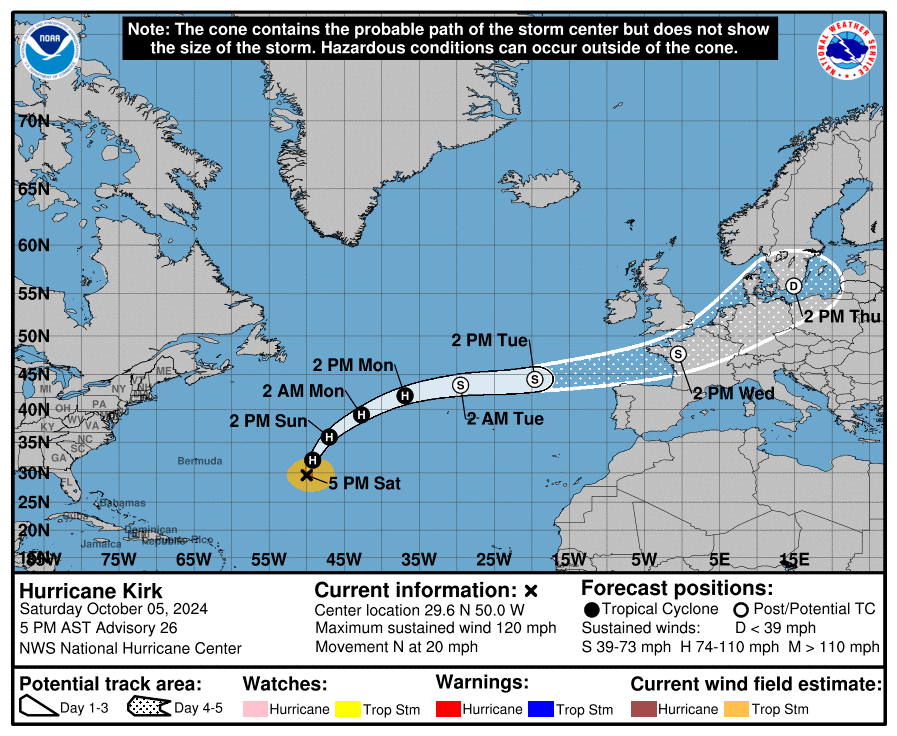
It seems like (the remnants of) Kirk could be one of the most impactful post-tropical cyclones for parts of Western Europe. While the official NHC has Kirk moving over the southern part of England onto the North Sea, the GEFS and ECMWF ensembles are a bit further south. The latter development would mean that the Dutch west coast won't see as strong winds with the center of Kirk moving right over us. Instead, the strongest wind speeds would be displaced further inland. Besides impacts from wind, we will probably also see a lot of rain from this post-tropical system as it passes close by.
The Extreme Forecast Indices (EFI) show indeed that the strongest wind gust anomalies (purple) are expected from roughly the Iberian Peninsula via France into Germany, while the more extreme precipitation (green) is forecast where the core of the system passes, so from northwestern France into Belgium and The Netherlands.
And for some reference: the strongest wind gust anywhere in The Netherlands this century for the first part of October was about 72 mph, and the lowest pressure about 977 mbar. Some ensemble members are showing a minimum central pressure of around 960 mb and wind gusts in excess of 85 mph. So this could in fact become quite an impactful (post-tropical) cyclone here, although there is still a lot of uncertainty of course. The Dutch National Weather Service (KNMI) has already put out a notification on the possibility of (very) strong wind gusts on Thursday.
ECMWF Ensemble Forecast for the southeastern part of The Netherlands (not the coastal area):
Extreme Forecast Index for Wednesday:
Extreme Forecast Index for Thursday:
3 likes
21-year old meteorologist and student MSc Climate Studies from The Netherlands. Interested in all fields of meteorology and climatology, including tropical systems like hurricanes.
-
Jelmergraaff
- Tropical Storm
- Posts: 138
- Age: 23
- Joined: Fri Aug 27, 2021 1:00 pm
- Location: The Netherlands
Re: ATL: KIRK - Hurricane - Discussion
Jelmergraaff wrote:It seems like (the remnants of) Kirk could be one of the most impactful post-tropical cyclones for parts of Western Europe. While the official NHC has Kirk moving over the southern part of England onto the North Sea, the GEFS and ECMWF ensembles are a bit further south. The latter development would mean that the Dutch west coast won't see as strong winds with the center of Kirk moving right over us. Instead, the strongest wind speeds would be displaced further inland. Besides impacts from wind, we will probably also see a lot of rain from this post-tropical system as it passes close by.
In fact, the new NHC forecast (09z) puts extra-tropical Kirk within 4 miles of my home at 120 hours. Not sure if I'll ever see that again in my life.
3 likes
21-year old meteorologist and student MSc Climate Studies from The Netherlands. Interested in all fields of meteorology and climatology, including tropical systems like hurricanes.
-
HurricaneBelle

- S2K Supporter

- Posts: 1209
- Joined: Sun Aug 27, 2006 6:12 pm
- Location: Clearwater, FL
Re: ATL: KIRK - Hurricane - Discussion
Jelmergraaff wrote:Jelmergraaff wrote:It seems like (the remnants of) Kirk could be one of the most impactful post-tropical cyclones for parts of Western Europe. While the official NHC has Kirk moving over the southern part of England onto the North Sea, the GEFS and ECMWF ensembles are a bit further south. The latter development would mean that the Dutch west coast won't see as strong winds with the center of Kirk moving right over us. Instead, the strongest wind speeds would be displaced further inland. Besides impacts from wind, we will probably also see a lot of rain from this post-tropical system as it passes close by.
In fact, the new NHC forecast (09z) puts extra-tropical Kirk within 4 miles of my home at 120 hours. Not sure if I'll ever see that again in my life.Of course there's quite some uncertainty at this point, but it'll be interesting to see how this turns out. And also if the NWS here will use 'Kirk' as the name, or one from the Northwest-European name list.
I just texted my son, who is studying this semester in Utrecht, that we both could be getting hurricanes this week as I'm in the Tampa Bay area warily watching 92L/future Milton.
3 likes
-
Sciencerocks
- Category 5
- Posts: 10193
- Age: 40
- Joined: Thu Jul 06, 2017 1:51 am

-
cycloneye
- Admin
- Posts: 149720
- Age: 69
- Joined: Thu Oct 10, 2002 10:54 am
- Location: San Juan, Puerto Rico
Re: ATL: KIRK - Hurricane - Discussion
AL, 12, 2024100512, , BEST, 0, 267N, 504W, 105, 949, HU
0 likes
Visit the Caribbean-Central America Weather Thread where you can find at first post web cams,radars
and observations from Caribbean basin members Click Here
and observations from Caribbean basin members Click Here
-
shear_vector
- Tropical Wave

- Posts: 7
- Joined: Sat Aug 24, 2024 9:16 am
Re: ATL: KIRK - Hurricane - Discussion
Is it unusal for the NHC to extend the TS force winds graphic into continental europe and the UK like it shows for Kirk?
I'm aware of the very strong extratropical cyclones that roll in but those usually take a different track but some are purely extratropical and some are post tropical. Sometimes I will tune into the UK Met office video updates (which are excellent btw) will do that for this system too. curious about impacts into continental europe along and inland from the coast...
Final question, where/what is that model that shows the 4 different sectors warm core/cold core plot?
0 likes
-
cycloneye
- Admin
- Posts: 149720
- Age: 69
- Joined: Thu Oct 10, 2002 10:54 am
- Location: San Juan, Puerto Rico
Re: ATL: KIRK - Hurricane - Discussion
AL, 12, 2024100518, , BEST, 0, 287N, 502W, 105, 949, HU
0 likes
Visit the Caribbean-Central America Weather Thread where you can find at first post web cams,radars
and observations from Caribbean basin members Click Here
and observations from Caribbean basin members Click Here
Re: ATL: KIRK - Hurricane - Discussion
cycloneye wrote:AL, 12, 2024100518, , BEST, 0, 287N, 502W, 105, 949, HU
Odd it’s being kept at 105 kt. Looks more like a Cat 2.
1 likes
Irene '11 Sandy '12 Hermine '16 5/15/2018 Derecho Fay '20 Isaias '20 Elsa '21 Henri '21 Ida '21
I am only a meteorology enthusiast who knows a decent amount about tropical cyclones. Look to the professional mets, the NHC, or your local weather office for the best information.
I am only a meteorology enthusiast who knows a decent amount about tropical cyclones. Look to the professional mets, the NHC, or your local weather office for the best information.

Re: ATL: KIRK - Hurricane - Discussion
aspen wrote:cycloneye wrote:AL, 12, 2024100518, , BEST, 0, 287N, 502W, 105, 949, HU
Odd it’s being kept at 105 kt. Looks more like a Cat 2.
The SAB fix was T4.5/5.5, ADT is being held over 100kt due to constraints, and due to a 110kt ATMS estimate SATCON is at 105kt. We also have the 946mb surface ob from this morning, with appearance improving since then:

7 likes
Kendall -> SLO -> PBC
Memorable Storms: Katrina (for its Florida landfall...) Wilma Matthew Irma
Memorable Storms: Katrina (for its Florida landfall...) Wilma Matthew Irma
-
Sciencerocks
- Category 5
- Posts: 10193
- Age: 40
- Joined: Thu Jul 06, 2017 1:51 am

-
CrazyC83
- Professional-Met
- Posts: 34316
- Joined: Tue Mar 07, 2006 11:57 pm
- Location: Deep South, for the first time!
Re: ATL: KIRK - Hurricane - Discussion
Still seems to be holding up decently at least in the core. This is pulling up the ACE, that is for sure...
0 likes
-
HurricaneRyan
- Category 3

- Posts: 847
- Age: 32
- Joined: Sun Dec 05, 2010 3:05 pm
Re: ATL: KIRK - Hurricane - Discussion
Probably the most interesting fish storm this season
2 likes
Kay '22 Hilary '23

Re: ATL: KIRK - Hurricane - Discussion
HurricaneRyan wrote:Probably the most interesting fish storm this season
Meteo france say it going to hit france and keep its tropical characteristic
1 likes
Who is online
Users browsing this forum: No registered users and 57 guests