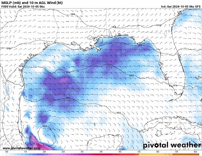
ATL: MILTON - Models

Moderator: S2k Moderators

Message
Author
USTropics
Category 5
Category 5
Posts: 2635
Joined: Sun Aug 12, 2007 3:45 am
Location: Florida State University

Re: ATL: INVEST 92L - Models

#61 Postby USTropics » Sat Oct 05, 2024 2:32 am

AxaltaRacing24 wrote:
NFLnut wrote:
SFLcane wrote:Don’t think your getting a major in 2-3 days or whatever the gfs is showing there. That looks silly.


Agree!

While not impossible, I don't see an almost-Cat4 hitting Tampa in 96-ish/108 hours! NHC isn't even hinting at a Hurricane and we are within their famous 5 day cone. I think the GFS is smoking crack with these runs.

In an era where RI is becoming more and more common, no point in just ruling these scenarios out before the storm even forms. We even have ensembles backing this up as well. Runs like that one are a reminder to prepare for the worst but hope for the best. Helene was a lesson, use it.


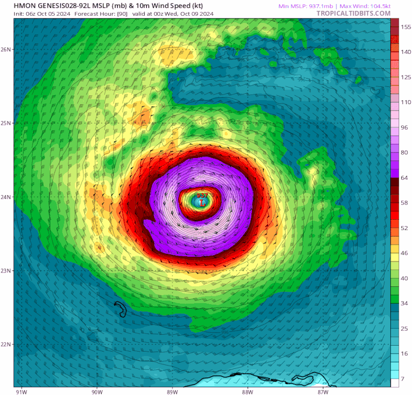
Intensity is the most difficult parameter to forecast, especially when there isn't even a consolidated center to track currently. Let's look at Helene as an example, here is the absolute error for intensity of the deterministic models:
Image

That's an average error of ~40 knots at 72 hours. This is where our hurricane models come into play, as they generally do a much better job at intensity (but have higher errors in track):
Image

While better, we still had an absolute error average of ~25 knots for all of the hurricane models at 72 hours.
4 likes   

User avatar
HurricaneBelle
S2K Supporter
S2K Supporter
Posts: 1169
Joined: Sun Aug 27, 2006 6:12 pm
Location: Clearwater, FL

Re: ATL: INVEST 92L - Models

#62 Postby HurricaneBelle » Sat Oct 05, 2024 5:31 am

The only good news for Tampa Bay on that 00Z GFS run is that on Thursday after Milton goes through, the high is only 80 with a dew point of 55 so folks won't be sweltering without power.
4 likes   

xironman
S2K Supporter
S2K Supporter
Posts: 2521
Joined: Sun Jun 10, 2007 4:53 pm
Location: NoVA

Re: ATL: INVEST 92L - Models

#63 Postby xironman » Sat Oct 05, 2024 5:31 am

Better run to run consistency

Image

Watch how the 250mb winds exit stage right as the storm moves east, that is what allows it to intensify

Image
3 likes   

caneman
Category 5
Category 5
Posts: 1446
Joined: Fri Sep 05, 2014 5:44 am
Location: Clearwater Beach, Fl

Re: ATL: INVEST 92L - Models

#64 Postby caneman » Sat Oct 05, 2024 5:49 am

xironman wrote:Better run to run consistency

https://i.imgur.com/GI810Zi.gif

Watch how the 250mb winds exit stage right as the storm moves east, that is what allows it to intensify

https://i.imgur.com/lj8m5I6.gif


Wtf. That ls strong too. Low end Cat. 3?
0 likes   

otowntiger
Category 5
Category 5
Posts: 1921
Joined: Tue Aug 31, 2004 7:06 pm

Re: ATL: INVEST 92L - Models

#65 Postby otowntiger » Sat Oct 05, 2024 6:00 am

The hurricane models are more aligned with all the other models that don’t take this thing beyond TS/ low end cat 1. It seems as if GFS is on an island all by itself.
:edit: I spoke too soon. HAF-a showing sub 940 system. :(
Last edited by otowntiger on Sat Oct 05, 2024 6:44 am, edited 1 time in total.
0 likes   

User avatar
drezee
S2K Supporter
S2K Supporter
Posts: 3664
Joined: Mon Jun 09, 2003 12:49 pm
Location: FL

Re: ATL: INVEST 92L - Models

#66 Postby drezee » Sat Oct 05, 2024 6:02 am

1 likes   

User avatar
Nimbus
Category 5
Category 5
Posts: 5274
Joined: Mon Jul 19, 2004 10:54 am

Re: ATL: INVEST 92L - Models

#67 Postby Nimbus » Sat Oct 05, 2024 6:03 am

xironman wrote:Better run to run consistency

https://i.imgur.com/GI810Zi.gif

Watch how the 250mb winds exit stage right as the storm moves east, that is what allows it to intensify

https://i.imgur.com/lj8m5I6.gif


The outflow from a stronger than expected storm would change the 250 mb wind pattern as it builds a dome of high pressure over the system. Currently looks like an elongated circulation which might delay development but recon data will help with that analysis.
1 likes   

xironman
S2K Supporter
S2K Supporter
Posts: 2521
Joined: Sun Jun 10, 2007 4:53 pm
Location: NoVA

Re: ATL: INVEST 92L - Models

#68 Postby xironman » Sat Oct 05, 2024 6:06 am

otowntiger wrote:The hurricane models are more aligned with all the other models that don’t take this thing beyond TS/ low end cat 1. It seems as if GFS is on an island all by itself.


Oh yeah, its on an island. But it is not that far offshore.

Image
2 likes   

User avatar
Nimbus
Category 5
Category 5
Posts: 5274
Joined: Mon Jul 19, 2004 10:54 am

Re: ATL: INVEST 92L - Models

#69 Postby Nimbus » Sat Oct 05, 2024 6:25 am

xironman wrote:
otowntiger wrote:The hurricane models are more aligned with all the other models that don’t take this thing beyond TS/ low end cat 1. It seems as if GFS is on an island all by itself.


Oh yeah, its on an island. But it is not that far offshore.

https://i.imgur.com/lVHXnb1.png


Currently there is anticyclonic flow centered over the gulf which might pull the LLC a little further north where the front can shear it. Haven't seen this modeled by the GFS yet they build the anticyclone later in the forecast.

You can see the shear angled towards NOLA in the WV imagery ATM.

https://www.tropicaltidbits.com/sat/sat ... uct=wv_mid
1 likes   

Fancy1002
Tropical Storm
Tropical Storm
Posts: 129
Joined: Sun Dec 25, 2022 3:47 pm

Re: ATL: INVEST 92L - Models

#70 Postby Fancy1002 » Sat Oct 05, 2024 6:26 am

HMON is having fun with this one, let’s see how the other three do.
0 likes   

xironman
S2K Supporter
S2K Supporter
Posts: 2521
Joined: Sun Jun 10, 2007 4:53 pm
Location: NoVA

Re: ATL: INVEST 92L - Models

#71 Postby xironman » Sat Oct 05, 2024 6:29 am

Fancy1002 wrote:HMON is having fun with this one, let’s see how the other three do.


I am wait to see if it can break 900 before posting. HFSA is no slouch at 938, HFSB is north and weak.
1 likes   

User avatar
chris_fit
Category 5
Category 5
Posts: 3222
Age: 42
Joined: Wed Sep 10, 2003 11:58 pm
Location: Tampa Bay Area, FL

Re: ATL: INVEST 92L - Models

#72 Postby chris_fit » Sat Oct 05, 2024 6:30 am

On my phone so Cant post a pic but no one looked at the 06z GFS yet? If you're near Tampa, maybe best you don't...

Edit... Sorry... Saw i posted above.
1 likes   

Fancy1002
Tropical Storm
Tropical Storm
Posts: 129
Joined: Sun Dec 25, 2022 3:47 pm

Re: ATL: INVEST 92L - Models

#73 Postby Fancy1002 » Sat Oct 05, 2024 6:35 am

Looks like an ewrc on the hmon.
0 likes   

otowntiger
Category 5
Category 5
Posts: 1921
Joined: Tue Aug 31, 2004 7:06 pm

Re: ATL: INVEST 92L - Models

#74 Postby otowntiger » Sat Oct 05, 2024 6:42 am

otowntiger wrote:The hurricane models are more aligned with all the other models that don’t take this thing beyond TS/ low end cat 1. It seems as if GFS is on an island all by itself.

I obviously spoke too soon- HAF-A showing sub 940 system approaching the FL coast. Uggh.
0 likes   

User avatar
gatorcane
S2K Supporter
S2K Supporter
Posts: 23689
Age: 47
Joined: Sun Mar 13, 2005 3:54 pm
Location: Boca Raton, FL

Re: ATL: INVEST 92L - Models

#75 Postby gatorcane » Sat Oct 05, 2024 6:43 am

06Z GFS :eek: . Remember the GFS was the model showing Helene being strong before other models picked up on that:

Image
1 likes   

Fancy1002
Tropical Storm
Tropical Storm
Posts: 129
Joined: Sun Dec 25, 2022 3:47 pm

Re: ATL: INVEST 92L - Models

#76 Postby Fancy1002 » Sat Oct 05, 2024 6:46 am

The only one that doesn’t bomb Milton out is B.
0 likes   

User avatar
ronjon
Category 5
Category 5
Posts: 4811
Joined: Fri Aug 19, 2005 5:17 pm
Location: Hernando Beach, FL

Re: ATL: INVEST 92L - Models

#77 Postby ronjon » Sat Oct 05, 2024 6:48 am

HAF-A at 926 mb heading for Tampa Bay at 102 hours.
1 likes   

User avatar
gatorcane
S2K Supporter
S2K Supporter
Posts: 23689
Age: 47
Joined: Sun Mar 13, 2005 3:54 pm
Location: Boca Raton, FL

Re: ATL: INVEST 92L - Models

#78 Postby gatorcane » Sat Oct 05, 2024 6:49 am

Yike some of the hurricane models area really making this strong. Here is the HMON so far. 929 MB!

Image
2 likes   

TomballEd
Category 2
Category 2
Posts: 580
Age: 61
Joined: Wed Aug 16, 2023 4:52 pm
Location: Spring/Klein area, not Tomball

Re: ATL: INVEST 92L - Models

#79 Postby TomballEd » Sat Oct 05, 2024 6:55 am

xironman wrote:Better run to run consistency

https://i.imgur.com/GI810Zi.gif

Watch how the 250mb winds exit stage right as the storm moves east, that is what allows it to intensify

https://i.imgur.com/lj8m5I6.gif


The upper pattern shown by the GFS is probably why it shows an intense storm. The storm is in the right entrance region of that jet, and there is outflow for the storm. I have no idea if the GFS is correct, but positive interaction with a strong jet to the N can't be discounted.
1 likes   

User avatar
cycloneye
Admin
Admin
Posts: 143865
Age: 68
Joined: Thu Oct 10, 2002 10:54 am
Location: San Juan, Puerto Rico

Re: ATL: INVEST 92L - Models

#80 Postby cycloneye » Sat Oct 05, 2024 7:02 am

HMON weakens approaching landfall just north of ClearWater but still is a strong cane at 941 mbs.

Image
2 likes   
Visit the Caribbean-Central America Weather Thread where you can find at first post web cams,radars
and observations from Caribbean basin members Click Here


Return to “2024”

Who is online

Users browsing this forum: No registered users and 4 guests