ATL: MILTON - Models
Moderator: S2k Moderators
-
AxaltaRacing24
- Category 5

- Posts: 1774
- Age: 25
- Joined: Wed Jul 27, 2016 11:14 am
- Location: Jupiter, FL
Re: ATL: MILTON - Models
Models runs like that one should show why South Florida isn’t the clear. Milton passes right over the treasure coast on that one, a county above Palm Beach. This is 117 hours out, that’s a close miss in this margin of error.
3 likes
-
Weathertracker96
- Tropical Storm

- Posts: 150
- Joined: Mon Oct 16, 2023 3:41 pm
Re: ATL: MILTON - Models
TampaWxLurker wrote:Interesting thing with that ICON run. Has it slowing down just before landfall, not full onshore until very early Thursday, then taking an almost due East track and exiting near Ft. Pierce/Vero Beach.
What’s causing that? I thought it would exit the state with a clean NE move. Is the jet making it turn east when it makes landfall?
0 likes
-
Blown Away

- S2K Supporter

- Posts: 10253
- Joined: Wed May 26, 2004 6:17 am
Re: ATL: MILTON - Models
TampaWxLurker wrote:Interesting thing with that ICON run. Has it slowing down just before landfall, not full onshore until very early Thursday, then taking an almost due East track and exiting near Ft. Pierce/Vero Beach.
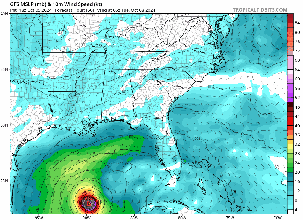
18z ICON… Slightly S of 12z at SW FL coast but decent S shift as it crosses peninsula into Atlantic.. Trend to watch!
2 likes
Hurricane Eye Experience: David 79, Irene 99, Frances 04, Jeanne 04, Wilma 05… Hurricane Brush Experience: Andrew 92, Erin 95, Floyd 99, Matthew 16, Irma 17, Ian 22, Nicole 22…
-
Weatherboy1

- Category 5
- Posts: 1190
- Age: 50
- Joined: Mon Jul 05, 2004 1:50 pm
- Location: Jupiter/Sarasota, FL
Re: ATL: MILTON - Models
Weathertracker96 wrote:TampaWxLurker wrote:Interesting thing with that ICON run. Has it slowing down just before landfall, not full onshore until very early Thursday, then taking an almost due East track and exiting near Ft. Pierce/Vero Beach.
What’s causing that? I thought it would exit the state with a clean NE move. Is the jet making it turn east when it makes landfall?
Looks like high pressure dropping further south in SE U.S. in this run, which flattens out the path after landfall
2 likes

Re: ATL: MILTON - Models
Blown Away wrote:TampaWxLurker wrote:Interesting thing with that ICON run. Has it slowing down just before landfall, not full onshore until very early Thursday, then taking an almost due East track and exiting near Ft. Pierce/Vero Beach.
[url]https://i.postimg.cc/CMtLCNZV/floop-icon-2024100518-sfcwind-mslp-gom.gif [/url]
18z ICON… Slightly S of 12z at SW FL coast but decent S shift as it crosses peninsula into Atlantic.. Trend to watch!
That run would make for a nasty day here where I live in Jupiter
0 likes
Re: ATL: MILTON - Models
Pelicane wrote:Pretty noticable SW shift in the GFS. Also slower like the ICON.
Track and intensity doesn't look all that different in the end come landfall.
0 likes
Re: ATL: MILTON - Models
18z GFS a little slower, landfall near Crystal River, FL, exit near Daytona Beach. Compared to 12z, it's a slight left shift on the landfall point, Atlantic exit point identical. It eventually poofs in the Atlantic, while a sneaky system rides up into the Keys behind it a week from Monday.


Last edited by BobHarlem on Sat Oct 05, 2024 5:42 pm, edited 4 times in total.
0 likes

-
gatorcane

- S2K Supporter
- Posts: 23704
- Age: 47
- Joined: Sun Mar 13, 2005 3:54 pm
- Location: Boca Raton, FL
Re: ATL: MILTON - Models
Saved 18Z GFS loop, comes in just south of Cedar Key with a noticeable NE turn as it approaches the west coast of Florida. Further south than the 12Z during the first couple of days.
0 likes
Re: ATL: MILTON - Models
18z GFS Crystal River  But pressure rises 20 mb the last 6 hrs prior to landfall.
0 likes
-
TampaWxLurker
- Tropical Storm
- Posts: 196
- Joined: Thu Aug 01, 2024 8:20 am
Re: ATL: MILTON - Models
Pretty big spread between the 18z ICON down around Venice/Englewood and the 18z GFS up in Citrus County.
But there is 1 thing they agree on. Slower approach. Landfall pushing into Thursday.
But there is 1 thing they agree on. Slower approach. Landfall pushing into Thursday.
0 likes


-
gatorcane
- S2K Supporter
- Posts: 23704
- Age: 47
- Joined: Sun Mar 13, 2005 3:54 pm
- Location: Boca Raton, FL
Re: ATL: MILTON - Models
Goes right around Tampa somehow probably thanks to the fact it is slowing down the overall track. I would definitely go with any model showing a trend away from Tampa given how rare it is for them to see a major hurricane hit.
1 likes

Re: ATL: MILTON - Models
TampaWxLurker wrote:Pretty big spread between the 18z ICON down around Venice/Englewood and the 18z GFS up in Citrus County.
But there is 1 thing they agree on. Slower approach. Landfall pushing into Thursday.
Icon was the outlier model for Helene and came into line later in the forecast.
The upper air modeling prior to landfall has more effect on where Milton makes landfall.
Not sure what the GFS is seeing this run for the NE turn but as you noted probably has something to do with slower approach.
0 likes
Re: ATL: MILTON - Models
Yeah, as usual models switch away from tampa area. Could switch back of course, but it rarely does... Holding out that hope it doesn't heh, but 18z big shift north isn't necessarily a great thing for the coastal people either way, especially if it comes in below cedar key, say crystal river heh
0 likes
-
DESTRUCTION5

- Category 5
- Posts: 4430
- Age: 44
- Joined: Wed Sep 03, 2003 11:25 am
- Location: Stuart, FL
Re: ATL: MILTON - Models
NDG wrote:Pretty soon the GFS is going to keep going north up to Perry.
Same GFS had a weak depression passing thru SF yesterday. Gonna change 10 times in next 3 days.
1 likes
GATOR NATION IS E V E R Y W H E R E !
Re: ATL: MILTON - Models
Both the 18z ICON and GFS have a more distinct turn to the east once they hit the west coast of FL compared to earlier runs
1 likes
Re: ATL: MILTON - Models
LandoWill wrote:Yeah, as usual models switch away from tampa area. Could switch back of course, but it rarely does... Holding out that hope it doesn't heh, but 18z big shift north isn't necessarily a great thing for the coastal people either way, especially if it comes in below cedar key, say crystal river heh
I was hoping for a deep digging October trough that would shred Milton but the current ULL vortex is way up in Canada and the models are slowing the track so they see something like a weaker front
0 likes
Who is online
Users browsing this forum: No registered users and 30 guests