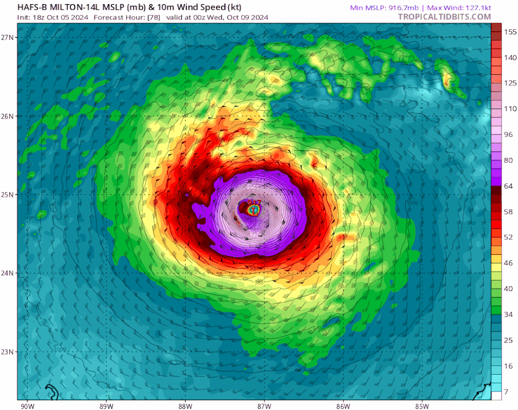
ATL: MILTON - Models

Moderator: S2k Moderators

Message
Author
User avatar
Steve
S2K Supporter
S2K Supporter
Posts: 9621
Joined: Sat Apr 05, 2003 11:41 pm
Location: Not a state-caster

Re: ATL: MILTON - Models

#261 Postby Steve » Sat Oct 05, 2024 6:44 pm

Teban54 wrote:
ConvergenceZone wrote:
Hypercane_Kyle wrote:
HAFS closer resembles the 4k NAM sometimes. Such an overcooked scenario is borderline absurd.


I always wonder, if models like this are overdoing intensity so often, why don't they just tweak the code that feeds into the model?

I'm not sure what the answer is, but keep in mind:
  • Kirk just became stronger than every single hurricane model showed;
  • Unless I'm mistaken, hurricane models (dating back to before HAFS was a thing) are still the best intensity models and have the smallest error in intensity among those available.


Somebody else will need to verify because all I got is anecdotes. But once they latch say 4-5 days out they crater pressures into unlikely depths of pressure. But within 72 or so they tend to adjust to what it’s going to be.
2 likes   

BobHarlem
Category 5
Category 5
Posts: 2108
Joined: Thu Oct 20, 2005 6:11 pm

Re: ATL: MILTON - Models

#262 Postby BobHarlem » Sat Oct 05, 2024 6:44 pm

Crystal River/Homosassa Springs landfall looks like on the 18z HAFS-B, pretty much the same spot as the 12z, except 6 hours later.


Image

1
Last edited by BobHarlem on Sat Oct 05, 2024 6:48 pm, edited 1 time in total.
2 likes   

xironman
S2K Supporter
S2K Supporter
Posts: 2522
Joined: Sun Jun 10, 2007 4:53 pm
Location: NoVA

Re: ATL: MILTON - Models

#263 Postby xironman » Sat Oct 05, 2024 6:45 pm

Steve wrote:
xironman wrote:
BobHarlem wrote:gross

https://i.imgur.com/2QdnFBi.png


Still no sub 900, the HAFSA did get to 901 though


Nam 3km will hopefully pull it off.


The 4k actually does a great job on extratropical storms to use it on tropical systems is just crazy
1 likes   

User avatar
ROCK
Category 5
Category 5
Posts: 9484
Age: 54
Joined: Tue Aug 17, 2004 7:30 am
Location: Kemah, Texas

Re: ATL: MILTON - Models

#264 Postby ROCK » Sat Oct 05, 2024 6:45 pm

Steve wrote:
xironman wrote:
BobHarlem wrote:gross

https://i.imgur.com/2QdnFBi.png


Still no sub 900, the HAFSA did get to 901 though


Nam 3km will hopefully pull it off.


Ha most likely!!
1 likes   

User avatar
Steve
S2K Supporter
S2K Supporter
Posts: 9621
Joined: Sat Apr 05, 2003 11:41 pm
Location: Not a state-caster

Re: ATL: MILTON - Models

#265 Postby Steve » Sat Oct 05, 2024 6:45 pm

BobHarlem wrote:Homosassa Springs landfall looks like on the 18z HAFS-B

https://i.imgur.com/Rex5exw.png

1


That’s 4 if not necessarily getting to the surface.
0 likes   

User avatar
NDG
S2K Supporter
S2K Supporter
Posts: 15446
Joined: Sun Jul 09, 2006 10:14 pm
Location: Orlando, FL

Re: ATL: MILTON - Models

#266 Postby NDG » Sat Oct 05, 2024 6:49 pm

The latest NHC forecast did the right thing of a MH at landfall with the hurricane models so strong today. Chances of a MH at landfall are very high.
5 likes   

TampaWxLurker
Tropical Depression
Tropical Depression
Posts: 99
Joined: Thu Aug 01, 2024 8:20 am

Re: ATL: MILTON - Models

#267 Postby TampaWxLurker » Sat Oct 05, 2024 6:54 pm

Final 18 hours before landfall in the HAFS-B, pressure rises from 915 to 950.
0 likes   

User avatar
Emmett_Brown
Category 5
Category 5
Posts: 1432
Joined: Wed Aug 24, 2005 9:10 pm
Location: Sarasota FL

Re: ATL: MILTON - Models

#268 Postby Emmett_Brown » Sat Oct 05, 2024 6:55 pm

Landfall times seem to be getting pushed out a little more each run
1 likes   

User avatar
gatorcane
S2K Supporter
S2K Supporter
Posts: 23691
Age: 47
Joined: Sun Mar 13, 2005 3:54 pm
Location: Boca Raton, FL

Re: ATL: MILTON - Models

#269 Postby gatorcane » Sat Oct 05, 2024 6:56 pm

TampaWxLurker wrote:Final 18 hours before landfall in the HAFS-B, pressure rises from 915 to 950.


Yes but not before Pinellas County, Pasco, Hernando including the Tampa Bay area get walloped, with the SE side (SW wind flow would create a massive storm surge).

Image
Last edited by gatorcane on Sat Oct 05, 2024 6:58 pm, edited 3 times in total.
2 likes   

Keldeo1997
Category 2
Category 2
Posts: 637
Joined: Fri Oct 11, 2019 11:35 pm

Re: ATL: MILTON - Models

#270 Postby Keldeo1997 » Sat Oct 05, 2024 6:56 pm

HAFS wants Rita but going the other way.
2 likes   

BobHarlem
Category 5
Category 5
Posts: 2108
Joined: Thu Oct 20, 2005 6:11 pm

Re: ATL: MILTON - Models

#271 Postby BobHarlem » Sat Oct 05, 2024 6:56 pm

18z HAFS A about the same landfall point as B, but time wise a little ahead of the B, but weaker at landfall, both a and b rapidly weaken as they approach landfall. This is a shift left/north of the 12z HAFS A Though.

Image
Last edited by BobHarlem on Sat Oct 05, 2024 7:00 pm, edited 1 time in total.
2 likes   

User avatar
Flwxguy86
Tropical Low
Tropical Low
Posts: 46
Age: 38
Joined: Sun Sep 15, 2024 11:06 am
Location: Oldsmar,FL

Re: ATL: MILTON - Models

#272 Postby Flwxguy86 » Sat Oct 05, 2024 6:59 pm

TampaWxLurker wrote:Final 18 hours before landfall in the HAFS-B, pressure rises from 915 to 950.

Kinda academic at thatp point honestly, It wil still be pushing water like the pressure is 915 and 950 is still a major hurricane. Seems like the models aren't backing down, I kinda thought they might but they seem to be getting stronger with each run but losing a tiny bit of steam right before landfall.
0 likes   

Tekken_Guy
Tropical Storm
Tropical Storm
Posts: 135
Joined: Fri Sep 01, 2017 8:08 pm

Re: ATL: MILTON - Models

#273 Postby Tekken_Guy » Sat Oct 05, 2024 7:01 pm

gatorcane wrote:
TampaWxLurker wrote:Final 18 hours before landfall in the HAFS-B, pressure rises from 915 to 950.


Yes but not before Pinellas County, Pasco, Hernando including the Tampa Bay area get walloped, with the SE side (SW wind flow would create a massive storm surge).

https://i.postimg.cc/HsGdQcFZ/hafsb-mslp-wind-14-L-fh78-105.gif


Thank god landfall isn’t in Pinellas though. That would be a total worst-case scenario.
2 likes   

User avatar
Hypercane_Kyle
Category 5
Category 5
Posts: 3352
Joined: Sat Mar 07, 2015 7:58 pm
Location: Cape Canaveral, FL

Re: ATL: MILTON - Models

#274 Postby Hypercane_Kyle » Sat Oct 05, 2024 7:04 pm

We'll see what happens. Personally, I'd want to see recon data before latching onto another Big Bend area landfall. I think the GFS and the respective hurricane models might be a little overcooked in the next 24 hours, resulting in a more poleward solution. This is a very different steering setup than Helene, intensity is going to matter a lot.
Last edited by Hypercane_Kyle on Sat Oct 05, 2024 7:04 pm, edited 1 time in total.
0 likes   
My posts are my own personal opinion, defer to the National Hurricane Center (NHC) and other NOAA products for decision making during hurricane season.

Cat5James
Category 1
Category 1
Posts: 417
Joined: Fri Sep 06, 2019 7:54 pm

Re: ATL: MILTON - Models

#275 Postby Cat5James » Sat Oct 05, 2024 7:04 pm

Tekken_Guy wrote:
gatorcane wrote:
TampaWxLurker wrote:Final 18 hours before landfall in the HAFS-B, pressure rises from 915 to 950.


Yes but not before Pinellas County, Pasco, Hernando including the Tampa Bay area get walloped, with the SE side (SW wind flow would create a massive storm surge).

https://i.postimg.cc/HsGdQcFZ/hafsb-mslp-wind-14-L-fh78-105.gif


Thank god landfall isn’t in Pinellas though. That would be a total worst-case scenario.

That is still very much a possibility
0 likes   

User avatar
NDG
S2K Supporter
S2K Supporter
Posts: 15446
Joined: Sun Jul 09, 2006 10:14 pm
Location: Orlando, FL

Re: ATL: MILTON - Models

#276 Postby NDG » Sat Oct 05, 2024 7:07 pm

Tekken_Guy wrote:
gatorcane wrote:
TampaWxLurker wrote:Final 18 hours before landfall in the HAFS-B, pressure rises from 915 to 950.


Yes but not before Pinellas County, Pasco, Hernando including the Tampa Bay area get walloped, with the SE side (SW wind flow would create a massive storm surge).

https://i.postimg.cc/HsGdQcFZ/hafsb-mslp-wind-14-L-fh78-105.gif


Thank god landfall isn’t in Pinellas though. That would be a total worst-case scenario.


Unfortunately the storm surge could be even worst than Helene.
0 likes   

User avatar
Spacecoast
Category 2
Category 2
Posts: 758
Joined: Thu Aug 31, 2017 2:03 pm

Re: ATL: MILTON - Models

#277 Postby Spacecoast » Sat Oct 05, 2024 7:07 pm

18z GEFS: Ens mean S of Tampa
Image
0 likes   

User avatar
chris_fit
Category 5
Category 5
Posts: 3222
Age: 42
Joined: Wed Sep 10, 2003 11:58 pm
Location: Tampa Bay Area, FL

Re: ATL: MILTON - Models

#278 Postby chris_fit » Sat Oct 05, 2024 7:09 pm

Spacecoast wrote:18z GEFS: Ens mean S of Tampa
https://i.ibb.co/sK5x5V7/gefs.jpg


Ahhh the infamous right hook right before landfall.
0 likes   

Steve H.
Category 5
Category 5
Posts: 2146
Joined: Sat Oct 19, 2002 9:06 am
Location: Palm Bay, Florida

Re: ATL: MILTON - Models

#279 Postby Steve H. » Sat Oct 05, 2024 7:09 pm

Well I have been wondering if Milton was going to make it all the way to Florida. Seems like the trough in the SE may begin to pull out and lose its grip on the storm, causing it to slow or stall. But I have learned over the years to put my money on the nhc. They will no for sure come Monday :spam:
0 likes   

Steve H.
Category 5
Category 5
Posts: 2146
Joined: Sat Oct 19, 2002 9:06 am
Location: Palm Bay, Florida

Re: ATL: MILTON - Models

#280 Postby Steve H. » Sat Oct 05, 2024 7:10 pm

:ggreen: Sorry, wrong imogie
0 likes   


Return to “2024”

Who is online

Users browsing this forum: No registered users and 1 guest