ATL: MILTON - Models
Moderator: S2k Moderators
Re: ATL: MILTON - Models
Not going to post the image, but the 0z GFS is adding insult to injury in the long range (See hours 282/288) but that belongs in the main global model thread.
7 likes
-
skillz305
- Category 1

- Posts: 312
- Joined: Sat Sep 08, 2018 11:10 am
- Location: Miami, Florida --> Vero Beach, Florida
Re: ATL: MILTON - Models
BobHarlem wrote:Not going to post the image, but the 0z GFS is adding insult to injury in the long range (See hours 282/288) but that belongs in the main global model thread.
Wow…. That is absurd
1 likes
 Hurricanes: Andrew 1992 - Irene 1999 - Frances 2004 - Jeanne 2004 - Katrina 2005 - Wilma 2005 - Matthew 2016 - Irma 2017 - Ian 2022 - Nicole 2022 - Milton 2024
-
Poonwalker
- Category 1
- Posts: 270
- Joined: Tue Sep 20, 2022 11:12 am
Re: ATL: MILTON - Models
Tekken_Guy wrote:Flwxguy86 wrote:TampaWxLurker wrote:Decent shift south, from Citrus County to mid-Pinellas. Still not good.
Seems pretty accurate, If you punch in the lat and long for right at or around landfall it's very close to st pete beach and mediera beach. Which is horrible for this area. Historic Storm Surge and winds this area has likely never seen in recorded history. Not looking forward to this but the models have been fairly consistent for quite a few runs now. The NHC cone seems a lot bigger than what the models seem to be hinting. I really want the Hurricane Hunters data tomorrow to see what changes if anything.
Would a Pinellas or a Pasco landfall be worse for the area?
Iam going to say at that angle the current GFS is a worst case scenario. That’s threading the needle though as any slight shift south from there is going to lessen the impact. Right now I’ll take the south shifts
3 likes
Re: ATL: MILTON - Models
Flwxguy86 wrote:caneman wrote:Tekken_Guy wrote:
Would a Pinellas or a Pasco landfall be worse for the area?
Pasco as it would be close enough to get the worst of the wind and would maximize surge.
Honestly, That is like picking your most favorite turd that you have to eat! lol Niether option is great and both expose Tampa bay to tremendous amounts of surge with high winds on top of the surge. Most ideal for Tampa would be a track down towards Ft. Meyers or a track way up near cedar key. Any in the middle are going to be varying degrees of some pretty intense weather.
Even Bradenton or Sarasota would lessen the surge for Tampa Bay.
0 likes
Re: ATL: MILTON - Models
North side will be the wet side...South side surge side. Pick your poison.
0 likes

Re: ATL: MILTON - Models
HAFS-B went nuts again. Drops it down to the sub-900s like it did with Helene.
I don't recall the HAFS models being so aggressive with storms in prior years, even without recon data. Wonder why it's doing it now for these two storms.
I don't recall the HAFS models being so aggressive with storms in prior years, even without recon data. Wonder why it's doing it now for these two storms.
2 likes
-
SconnieCane
- Category 5

- Posts: 1013
- Joined: Thu Aug 02, 2018 5:29 pm
- Location: Madison, WI
Re: ATL: MILTON - Models
Pelicane wrote:HAFS-B went nuts again. Drops it down to the sub-900s like it did with Helene.
I don't recall the HAFS models being so aggressive with storms in prior years, even without recon data. Wonder why it's doing it now for these two storms.
Oh ****, I was just watching the 0Z HAFS-A run and I thought 916 MB at FH069 was bad. HAFS-B: "Hold my beer."
0 likes
-
Keldeo1997
- Category 2

- Posts: 688
- Joined: Fri Oct 11, 2019 11:35 pm

Re: ATL: MILTON - Models
Welcome back RIta. 


3 likes
Igor 2010, Sandy 2012, Fay 2014, Gonzalo 2014, Joaquin 2015, Nicole 2016, Humberto 2019, Imelda 2025
I am only a tropical weather enthusiast. My predictions are not official and may or may not be backed by sound meteorological data. For official information, please refer to the NHC and NWS products.
I am only a tropical weather enthusiast. My predictions are not official and may or may not be backed by sound meteorological data. For official information, please refer to the NHC and NWS products.

Re: ATL: MILTON - Models
Kazmit wrote:Welcome back RIta.
https://i.ibb.co/dj5C3NC/hafsb-mslp-wind-14-L-27.png
https://i.ibb.co/rZLsgwB/hafsb-sat-IR-14-L-28.png
What's the record for 10m wind speed from any HAFS-B run? The frame just before the one you posted showed 167.7 kt. Even with Helene, the model's wind speeds were nowhere near as high.
2 likes
TC naming lists: retirements and intensity
Most aggressive Advisory #1's in North Atlantic (cr. kevin for starting the list)
Most aggressive Advisory #1's in North Atlantic (cr. kevin for starting the list)
-
ElectricStorm

- Category 5
- Posts: 5141
- Age: 25
- Joined: Tue Aug 13, 2019 11:23 pm
- Location: Norman, OK
Re: ATL: MILTON - Models
HMON joining in at 917mb so far...
Winds aren't nearly as high as the HAFS
Winds aren't nearly as high as the HAFS
1 likes
B.S Meteorology, University of Oklahoma '25
Please refer to the NHC, NWS, or SPC for official information.
Please refer to the NHC, NWS, or SPC for official information.
-
ElectricStorm
- Category 5
- Posts: 5141
- Age: 25
- Joined: Tue Aug 13, 2019 11:23 pm
- Location: Norman, OK
Re: ATL: MILTON - Models
Massive weakening before landfall on the HAFS-B, from Cat 5 to Cat 1 in 9 hours
2 likes
B.S Meteorology, University of Oklahoma '25
Please refer to the NHC, NWS, or SPC for official information.
Please refer to the NHC, NWS, or SPC for official information.
-
Flwxguy86

- Tropical Depression

- Posts: 51
- Age: 39
- Joined: Sun Sep 15, 2024 11:06 am
- Location: Oldsmar,FL
Re: ATL: MILTON - Models
HAFS-B is on crack, No other model shows that kinda strength. I can't imagine the kind of storm surge a storm that powerful would push out ahead of it even with it weakening before landfall. If I see it get this low I'd be very very very surpised.
0 likes

Re: ATL: MILTON - Models
Kazmit wrote:Welcome back RIta.
https://i.ibb.co/dj5C3NC/hafsb-mslp-wind-14-L-27.png
https://i.ibb.co/rZLsgwB/hafsb-sat-IR-14-L-28.png
That's just insane.
0 likes
Andy D
(For official information, please refer to the NHC and NWS products.)
(For official information, please refer to the NHC and NWS products.)

Re: ATL: MILTON - Models
For any of these extremely explosive solutions to verify, it looks like we'd need to start seeing explosive intensification by tomorrow evening. Milton looks to be quite a small system, which could be either its boon or burden. On one hand, it would aid in such explosive intensification should conditions be as optimal as suggested at this point in the western GOM, but on the other, anything that's not evident (unforeseen dry air intrusion or shear) could wreck Milton's internal structure far more significantly than it would to a larger, more robust storm.
2 likes
-
Blown Away

- S2K Supporter

- Posts: 10253
- Joined: Wed May 26, 2004 6:17 am
Re: ATL: MILTON - Models
00z Canadian… Ft. Myers area…
1 likes
Hurricane Eye Experience: David 79, Irene 99, Frances 04, Jeanne 04, Wilma 05… Hurricane Brush Experience: Andrew 92, Erin 95, Floyd 99, Matthew 16, Irma 17, Ian 22, Nicole 22…
-
otowntiger
- Category 5
- Posts: 1932
- Joined: Tue Aug 31, 2004 7:06 pm
Re: ATL: MILTON - Models
ElectricStorm wrote:Massive weakening before landfall on the HAFS-B, from Cat 5 to Cat 1 in 9 hours
Yes all the hurricane models seem to be doing this. I think that a great sign that it seems a good chance that intense winds may not be as much of a problem as they might’ve been, especially inland. Unfortunately the surge could still be massive due to the power it would have in the open water thereby generating the waves and push of water.
1 likes
Re: ATL: MILTON - Models
BobHarlem wrote:Not going to post the image, but the 0z GFS is adding insult to injury in the long range (See hours 282/288) but that belongs in the main global model thread.
I was looking at that storm last week. And then, Milton decided to butt in.
We don't need two major in two weeks!
0 likes
-
Blown Away
- S2K Supporter
- Posts: 10253
- Joined: Wed May 26, 2004 6:17 am
Re: ATL: MILTON - Models
00z ICON… Cape Coral area…
2 likes
Hurricane Eye Experience: David 79, Irene 99, Frances 04, Jeanne 04, Wilma 05… Hurricane Brush Experience: Andrew 92, Erin 95, Floyd 99, Matthew 16, Irma 17, Ian 22, Nicole 22…
-
Blown Away
- S2K Supporter
- Posts: 10253
- Joined: Wed May 26, 2004 6:17 am
Re: ATL: MILTON - Models
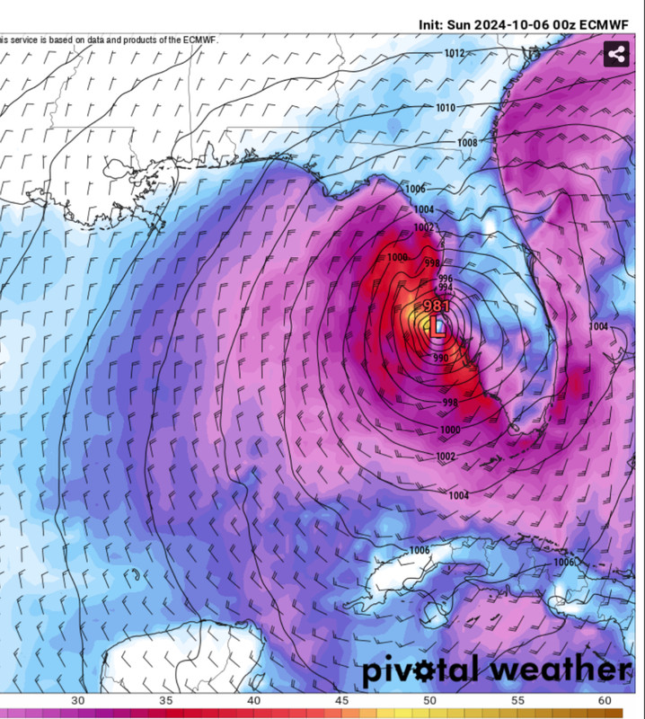
00z EURO… Decent S shift, now coming in S of Tampa compared to 12z…
2 likes
Hurricane Eye Experience: David 79, Irene 99, Frances 04, Jeanne 04, Wilma 05… Hurricane Brush Experience: Andrew 92, Erin 95, Floyd 99, Matthew 16, Irma 17, Ian 22, Nicole 22…
Who is online
Users browsing this forum: No registered users and 13 guests