ATL: MILTON - Models

Moderator: S2k Moderators

Message
Author
Cat5James
Category 1
Category 1
Posts: 417
Joined: Fri Sep 06, 2019 7:54 pm

Re: ATL: MILTON - Models

#501 Postby Cat5James » Sun Oct 06, 2024 11:13 am

Travorum wrote:The full 12z GFS run. As everyone has said, it dips further south while passing the Yucatan but takes a steeper angle of approach on the approach to Florida ending up around Crystal River.
https://i.imgur.com/Ci3Vq9E.gif

Any less steep of an angle and that is going directly into Tampa Bay
0 likes   

User avatar
SFLcane
S2K Supporter
S2K Supporter
Posts: 10163
Age: 47
Joined: Sat Jun 05, 2010 1:44 pm
Location: Lake Worth Florida

Re: ATL: MILTON - Models

#502 Postby SFLcane » Sun Oct 06, 2024 11:18 am

Image
0 likes   

User avatar
kevin
Category 5
Category 5
Posts: 2586
Age: 26
Joined: Wed Aug 28, 2019 4:35 am

Re: ATL: MILTON - Models

#503 Postby kevin » Sun Oct 06, 2024 11:26 am

12z guidance. 12 out of 18 models show a MH peak and 2 models have a C5 peak.

Image
1 likes   

floridasun
Tropical Storm
Tropical Storm
Posts: 203
Joined: Tue Sep 14, 2021 3:59 pm

Re: ATL: MILTON - Models

#504 Postby floridasun » Sun Oct 06, 2024 11:27 am

who will nhc go with at 5pm gfs vs rest models
0 likes   

User avatar
kevin
Category 5
Category 5
Posts: 2586
Age: 26
Joined: Wed Aug 28, 2019 4:35 am

Re: ATL: MILTON - Models

#505 Postby kevin » Sun Oct 06, 2024 11:28 am

floridasun wrote:who will nhc go with at 5pm gfs vs rest models


By then we will also have the 12z Euro (+ the GEFS and Euro ensembles). If Euro joins GFS they'll probably go with that, otherwise they'll lean more heavily towards the southern models.
0 likes   

BobHarlem
Category 5
Category 5
Posts: 2108
Joined: Thu Oct 20, 2005 6:11 pm

Re: ATL: MILTON - Models

#506 Postby BobHarlem » Sun Oct 06, 2024 11:30 am

floridasun wrote:who will nhc go with at 5pm gfs vs rest models


Probably split the difference and make no change to the track.
1 likes   

User avatar
CronkPSU
S2K Supporter
S2K Supporter
Posts: 2014
Joined: Sun Aug 07, 2005 10:44 pm
Location: Avalon Park, FL

Re: ATL: MILTON - Models

#507 Postby CronkPSU » Sun Oct 06, 2024 11:31 am

floridasun wrote:who will nhc go with at 5pm gfs vs rest models


Isn’t just the GFS up there…most are up there now
0 likes   
Just like Jon Snow..."I know nothing" except what I know, and most of what I know is gathered by the fine people of the NHC

caneman
Category 5
Category 5
Posts: 1447
Joined: Fri Sep 05, 2014 5:44 am
Location: Clearwater Beach, Fl

Re: ATL: MILTON - Models

#508 Postby caneman » Sun Oct 06, 2024 11:32 am

kevin wrote:
floridasun wrote:who will nhc go with at 5pm gfs vs rest models


By then we will also have the 12z Euro (+ the GEFS and Euro ensembles). If Euro joins GFS they'll probably go with that, otherwise they'll lean more heavily towards the southern models.


I doubt it. THE NHC already stated that they're leaning more on the EURO and GFS so it would be a blend. I think they realized with Helene they put too much stock in other models.
1 likes   

User avatar
StPeteMike
Category 2
Category 2
Posts: 631
Joined: Thu Jun 07, 2018 11:26 pm

Re: ATL: MILTON - Models

#509 Postby StPeteMike » Sun Oct 06, 2024 11:39 am

CronkPSU wrote:
floridasun wrote:who will nhc go with at 5pm gfs vs rest models


Isn’t just the GFS up there…most are up there now

Don’t all the HMON, HAFS and HWRf have it still on the northern end?
1 likes   
The above post is not official and should not be used as such. It is the opinion of the poster and may or may not be backed by sound meteorological data. It is not endorsed by any professional institution or storm2k.org. For official information, please refer to the NHC and NWS products.

User avatar
CronkPSU
S2K Supporter
S2K Supporter
Posts: 2014
Joined: Sun Aug 07, 2005 10:44 pm
Location: Avalon Park, FL

Re: ATL: MILTON - Models

#510 Postby CronkPSU » Sun Oct 06, 2024 11:41 am

StPeteMike wrote:
CronkPSU wrote:
floridasun wrote:who will nhc go with at 5pm gfs vs rest models


Isn’t just the GFS up there…most are up there now

Don’t all the HMON, HAFS and HWRf have it still on the northern end?


Yes
1 likes   
Just like Jon Snow..."I know nothing" except what I know, and most of what I know is gathered by the fine people of the NHC

BIFF_THE_UNRULY
Tropical Storm
Tropical Storm
Posts: 143
Joined: Fri Jun 28, 2024 2:12 pm

Re: ATL: MILTON - Models

#511 Postby BIFF_THE_UNRULY » Sun Oct 06, 2024 11:47 am

NHC will probably keep their track into Tampa bay. Maybe a little south to Sarasota imo
0 likes   

User avatar
DESTRUCTION5
Category 5
Category 5
Posts: 4423
Age: 43
Joined: Wed Sep 03, 2003 11:25 am
Location: Stuart, FL

Re: ATL: MILTON - Models

#512 Postby DESTRUCTION5 » Sun Oct 06, 2024 11:48 am

12z UKMet holds firm with a Ft Meyers to Treasure Coast exit.
0 likes   
GATOR NATION IS E V E R Y W H E R E !

psyclone
S2K Supporter
S2K Supporter
Posts: 4762
Joined: Wed Aug 24, 2005 9:04 pm
Location: palm harbor fl

Re: ATL: MILTON - Models

#513 Postby psyclone » Sun Oct 06, 2024 11:49 am

That GFS run would be terrible for Tampa Bay and the nature coast....a surge wipeout
1 likes   

User avatar
MetroMike
Category 4
Category 4
Posts: 952
Joined: Sun Aug 29, 2004 8:13 pm
Location: Tampa Bay
Contact:

Re: ATL: MILTON - Models

#514 Postby MetroMike » Sun Oct 06, 2024 11:49 am

No sense in breathing easier as I admit I was here in Clearwater this morning.
Have to stay vigilant and strong.
1 likes   

BIFF_THE_UNRULY
Tropical Storm
Tropical Storm
Posts: 143
Joined: Fri Jun 28, 2024 2:12 pm

Re: ATL: MILTON - Models

#515 Postby BIFF_THE_UNRULY » Sun Oct 06, 2024 11:51 am

psyclone wrote:That GFS run would be terrible for Tampa Bay and the nature coast....a surge wipeout


We are still 3 days out. Anything can happen
1 likes   

tolakram
Admin
Admin
Posts: 20009
Age: 62
Joined: Sun Aug 27, 2006 8:23 pm
Location: Florence, KY (name is Mark)

Re: ATL: MILTON - Models

#516 Postby tolakram » Sun Oct 06, 2024 11:56 am

HAFS running

Image

Image
2 likes   
M a r k
- - - - -
Join us in chat: Storm2K Chatroom Invite. Android and IOS apps also available.

The posts in this forum are NOT official forecasts and should not be used as such. Posts are NOT endorsed by any professional institution or STORM2K.org. For official information and forecasts, please refer to NHC and NWS products.

shah83
Category 1
Category 1
Posts: 302
Joined: Sun Jul 31, 2016 4:55 pm

Re: ATL: MILTON - Models

#517 Postby shah83 » Sun Oct 06, 2024 11:58 am

HAFS-A going with bigger eye, and bigger radius of storm winds at the start.
0 likes   

User avatar
eastcoastFL
Category 5
Category 5
Posts: 3901
Age: 43
Joined: Thu Apr 12, 2007 12:29 pm
Location: Palm City, FL

Re: ATL: MILTON - Models

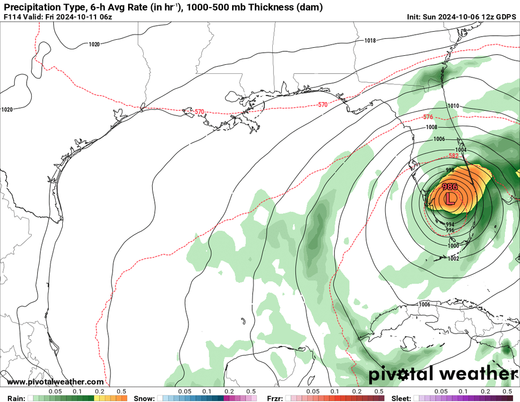
#518 Postby eastcoastFL » Sun Oct 06, 2024 12:05 pm

DESTRUCTION5 wrote:12z UKMet holds firm with a Ft Meyers to Treasure Coast exit.


I'm glad that's an outlier right now. It's going to be a stressful couple of days. I'm gonna have to try and work and keep an eye on the storm/models tomorrow.
0 likes   
Personal Forecast Disclaimer:
The posts in this forum are NOT official forecast and should not be used as such. They are just the opinion of the poster and may or may not be backed by sound meteorological data. They are NOT endorsed by any professional institution or storm2k.org. For official information, please refer to the NHC and NWS products.

User avatar
eastcoastFL
Category 5
Category 5
Posts: 3901
Age: 43
Joined: Thu Apr 12, 2007 12:29 pm
Location: Palm City, FL

Re: ATL: MILTON - Models

#519 Postby eastcoastFL » Sun Oct 06, 2024 12:06 pm


That's a lot of strengthening between now and Tues.
0 likes   
Personal Forecast Disclaimer:
The posts in this forum are NOT official forecast and should not be used as such. They are just the opinion of the poster and may or may not be backed by sound meteorological data. They are NOT endorsed by any professional institution or storm2k.org. For official information, please refer to the NHC and NWS products.

User avatar
SFLcane
S2K Supporter
S2K Supporter
Posts: 10163
Age: 47
Joined: Sat Jun 05, 2010 1:44 pm
Location: Lake Worth Florida

Re: ATL: MILTON - Models

#520 Postby SFLcane » Sun Oct 06, 2024 12:06 pm

eastcoastFL wrote:
DESTRUCTION5 wrote:12z UKMet holds firm with a Ft Meyers to Treasure Coast exit.


I'm glad that's an outlier right now. It's going to be a stressful couple of days. I'm gonna have to try and work and keep an eye on the storm/models tomorrow.


Nothing is an outlier lol it’s well within the nhc cone.
1 likes   


Return to “2024”

Who is online

Users browsing this forum: No registered users and 3 guests