ATL: MILTON - Models

Moderator: S2k Moderators

Message
Author
User avatar
Blown Away
S2K Supporter
S2K Supporter
Posts: 10146
Joined: Wed May 26, 2004 6:17 am

Re: ATL: MILTON - Models

#681 Postby Blown Away » Sun Oct 06, 2024 11:47 pm

caneman wrote:
Blown Away wrote:
caneman wrote:
I think its narrowing further to maybe Port Charlotte or Venice on the Southern end. Throwing out the mostly useless Canadian


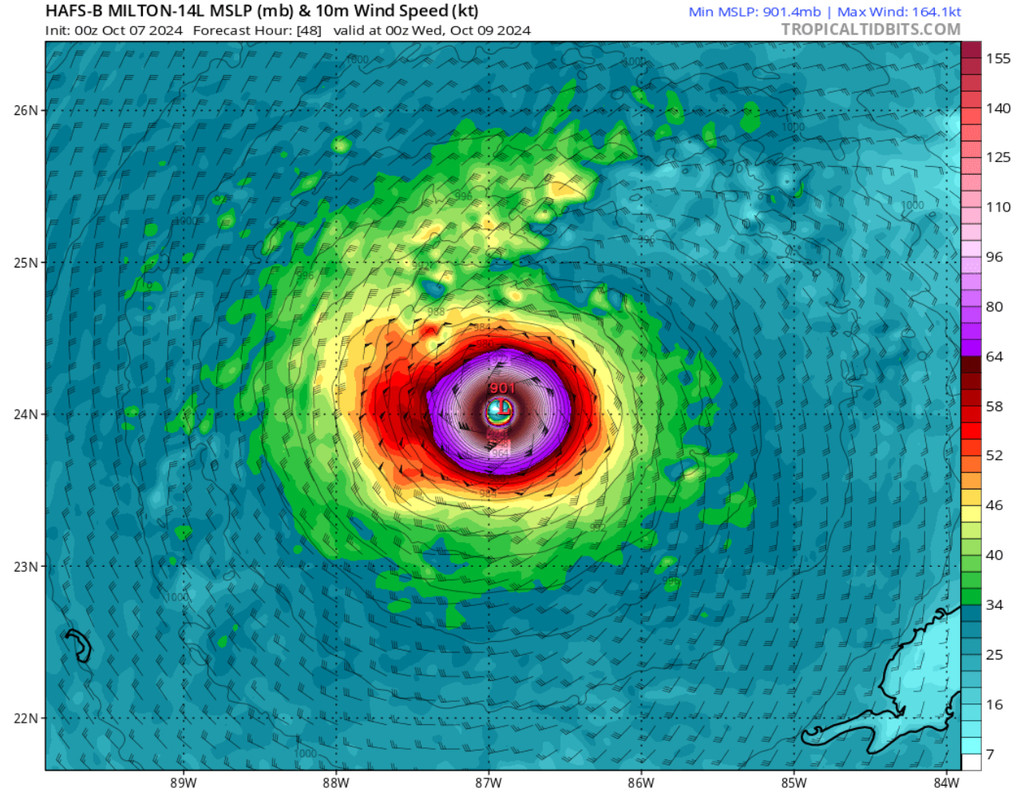
Nah man, can’t make any definitive decisions that narrow 3-4 days out. I always like to throw climatology in the mix, and a direct MH landfall between Englewood to Tampa is very rare. ATM, looks like that may change, but still plenty of time to shift 100 miles in any direction.


We will see. I'm not a big climatology as we don't have enough history and data set and each year and each storm adds a new mix to climatology and new firsts.


No doubt, climatology for MH for Tampa being tested here with the current model runs.
If it’s been over a 100 years since it last happened, I’m betting against it.
1 likes   
Hurricane Eye Experience: David 79, Irene 99, Frances 04, Jeanne 04, Wilma 05... EYE COMING MY WAY IN 2024…
Hurricane Brush Experience: Andrew 92, Erin 95, Floyd 99, Matthew 16, Irma 17, Ian 22, Nicole 22…

User avatar
ElectricStorm
Category 5
Category 5
Posts: 5044
Age: 24
Joined: Tue Aug 13, 2019 11:23 pm
Location: Skiatook, OK / Norman, OK

Re: ATL: MILTON - Models

#682 Postby ElectricStorm » Sun Oct 06, 2024 11:58 pm

Here we go with the 0z hurricane models, HAFS-B has 150kts by 0z tomorrow (7pm CDT)
1 likes   
B.S Meteorology, University of Oklahoma '25

Please refer to the NHC, NWS, or SPC for official information.

User avatar
ElectricStorm
Category 5
Category 5
Posts: 5044
Age: 24
Joined: Tue Aug 13, 2019 11:23 pm
Location: Skiatook, OK / Norman, OK

Re: ATL: MILTON - Models

#683 Postby ElectricStorm » Mon Oct 07, 2024 12:02 am

Anyone know much about that island north of the Yucatan? Both HAFS have an absolute monster Cat 5 going right over it
0 likes   
B.S Meteorology, University of Oklahoma '25

Please refer to the NHC, NWS, or SPC for official information.

USTropics
Professional-Met
Professional-Met
Posts: 2651
Joined: Sun Aug 12, 2007 3:45 am
Location: Florida State University

Re: ATL: MILTON - Models

#684 Postby USTropics » Mon Oct 07, 2024 12:03 am

GFS 00z ensembles, less spread this run:
Image
0 likes   

User avatar
CFLHurricane
Category 1
Category 1
Posts: 346
Joined: Thu Mar 27, 2014 5:56 pm
Location: Floriduh

Re: ATL: MILTON - Models

#685 Postby CFLHurricane » Mon Oct 07, 2024 12:05 am

ElectricStorm wrote:Anyone know much about that island north of the Yucatan? Both HAFS have an absolute monster Cat 5 going right over it


Per Wikipedia, Scorpion Island is part an atoll that is a major bird sanctuary. The only people there is a contingent of Mexican military personnel, who have hopefully evacuated.
3 likes   
I'm not a meteorologist, but I did stay at a motel 8.

User avatar
Teban54
Category 5
Category 5
Posts: 3206
Joined: Sat May 19, 2018 1:19 pm

Re: ATL: MILTON - Models

#686 Postby Teban54 » Mon Oct 07, 2024 12:07 am

CFLHurricane wrote:
ElectricStorm wrote:Anyone know much about that island north of the Yucatan? Both HAFS have an absolute monster Cat 5 going right over it


Per Wikipedia, Scorpion Island is part an atoll that is a major bird sanctuary. The only people there is a contingent of Mexican military personnel, who have hopefully evacuated.

Obviously human impacts are what people focus on, but I can't help but feel bad for the birds.
2 likes   

User avatar
Blown Away
S2K Supporter
S2K Supporter
Posts: 10146
Joined: Wed May 26, 2004 6:17 am

Re: ATL: MILTON - Models

#687 Postby Blown Away » Mon Oct 07, 2024 12:08 am

Image

Not often you see a modeled 188 mph hurricane… :eek:
3 likes   
Hurricane Eye Experience: David 79, Irene 99, Frances 04, Jeanne 04, Wilma 05... EYE COMING MY WAY IN 2024…
Hurricane Brush Experience: Andrew 92, Erin 95, Floyd 99, Matthew 16, Irma 17, Ian 22, Nicole 22…

User avatar
Woofde
Category 1
Category 1
Posts: 480
Joined: Tue Jul 06, 2021 11:33 am

Re: ATL: MILTON - Models

#688 Postby Woofde » Mon Oct 07, 2024 12:09 am

Blown Away wrote:Image

Not often you see a modeled 188 mph hurricane… :eek:
I think this one is a little more realistic contender than the runs we saw with Helene. It has such a tight core, could ramp fast.
5 likes   

Keldeo1997
Category 2
Category 2
Posts: 637
Joined: Fri Oct 11, 2019 11:35 pm

Re: ATL: MILTON - Models

#689 Postby Keldeo1997 » Mon Oct 07, 2024 12:10 am

Despite Recon data into the models both HAFS still bomb out to sub 900MB 160Kt CAT 5s. I mean we'll see but its crazy to see the run to run consistency.
Last edited by Keldeo1997 on Mon Oct 07, 2024 12:30 am, edited 1 time in total.
3 likes   

User avatar
ElectricStorm
Category 5
Category 5
Posts: 5044
Age: 24
Joined: Tue Aug 13, 2019 11:23 pm
Location: Skiatook, OK / Norman, OK

Re: ATL: MILTON - Models

#690 Postby ElectricStorm » Mon Oct 07, 2024 12:21 am

Alright HAFS you can stop now
Image
Image
6 likes   
B.S Meteorology, University of Oklahoma '25

Please refer to the NHC, NWS, or SPC for official information.

User avatar
Woofde
Category 1
Category 1
Posts: 480
Joined: Tue Jul 06, 2021 11:33 am

Re: ATL: MILTON - Models

#691 Postby Woofde » Mon Oct 07, 2024 12:30 am

ElectricStorm wrote:Alright HAFS you can stop now
Image
Image
I think HAFS may be a bit overtuned for these super intense hurricanes. HWRF and HMON looks much more realistic, as did they with Helene. I'm not going to be thrilled if they do end up retiring these two models.ImageImage
1 likes   

LandoWill
Tropical Storm
Tropical Storm
Posts: 154
Joined: Sun Sep 25, 2022 10:25 pm

Re: ATL: MILTON - Models

#692 Postby LandoWill » Mon Oct 07, 2024 12:31 am

ECMWF seems faster on their 00z
0 likes   

User avatar
Blown Away
S2K Supporter
S2K Supporter
Posts: 10146
Joined: Wed May 26, 2004 6:17 am

Re: ATL: MILTON - Models

#693 Postby Blown Away » Mon Oct 07, 2024 12:33 am

One positive is models are also consistently showing Cat 2/3 as Milton approaches the coast.
0 likes   
Hurricane Eye Experience: David 79, Irene 99, Frances 04, Jeanne 04, Wilma 05... EYE COMING MY WAY IN 2024…
Hurricane Brush Experience: Andrew 92, Erin 95, Floyd 99, Matthew 16, Irma 17, Ian 22, Nicole 22…

Fancy1002
Tropical Storm
Tropical Storm
Posts: 135
Joined: Sun Dec 25, 2022 3:47 pm

Re: ATL: MILTON - Models

#694 Postby Fancy1002 » Mon Oct 07, 2024 12:33 am

So the HAFS are nuts, and the HMON is worst case scenario, let’s see what HWRF does.
0 likes   

User avatar
ElectricStorm
Category 5
Category 5
Posts: 5044
Age: 24
Joined: Tue Aug 13, 2019 11:23 pm
Location: Skiatook, OK / Norman, OK

Re: RE: Re: ATL: MILTON - Models

#695 Postby ElectricStorm » Mon Oct 07, 2024 12:34 am

Woofde wrote:
ElectricStorm wrote:Alright HAFS you can stop now
https://i.imgur.com/heYUNx9.png
https://i.imgur.com/Ugucck8.png
I think HAFS may be a bit overtuned for these super intense hurricanes. HWRF and HMON looks much more realistic, as did they with Helene. I'm not going to be thrilled if they do end up retiring these two models.https://uploads.tapatalk-cdn.com/20241007/b1fac79c84146949f8b3a7e4810e9059.jpg https://uploads.tapatalk-cdn.com/20241007/07fb7d2db8de14551f195508a38fb993.jpg

Yeah I agree although I think this will likely be stronger than the low end Cat 4 the HWRF and HMON have. I wouldn't be surprised at all if it makes a Cat 5 run but I'll be shocked if if goes sub 900/165kts+ like the HAFS.

But unfortunately I believe HMON and HWRF are done after November :(
3 likes   
B.S Meteorology, University of Oklahoma '25

Please refer to the NHC, NWS, or SPC for official information.

Fancy1002
Tropical Storm
Tropical Storm
Posts: 135
Joined: Sun Dec 25, 2022 3:47 pm

Re: ATL: MILTON - Models

#696 Postby Fancy1002 » Mon Oct 07, 2024 12:36 am

Blown Away wrote:One positive is models are also consistently showing Cat 2/3 as Milton approaches the coast.

I don’t think that will help with the storm surge that was already built up. I remember Katrina land falling as a three with a storm surge of her former cat five self.
4 likes   

User avatar
Blown Away
S2K Supporter
S2K Supporter
Posts: 10146
Joined: Wed May 26, 2004 6:17 am

Re: ATL: MILTON - Models

#697 Postby Blown Away » Mon Oct 07, 2024 12:37 am

Fancy1002 wrote:So the HAFS are nuts, and the HMON is worst case scenario, let’s see what HWRF does.


Decent S shift in HMON at landfall near Tampa.
0 likes   
Hurricane Eye Experience: David 79, Irene 99, Frances 04, Jeanne 04, Wilma 05... EYE COMING MY WAY IN 2024…
Hurricane Brush Experience: Andrew 92, Erin 95, Floyd 99, Matthew 16, Irma 17, Ian 22, Nicole 22…

LandoWill
Tropical Storm
Tropical Storm
Posts: 154
Joined: Sun Sep 25, 2022 10:25 pm

Re: ATL: MILTON - Models

#698 Postby LandoWill » Mon Oct 07, 2024 12:38 am

Image
0 likes   

LandoWill
Tropical Storm
Tropical Storm
Posts: 154
Joined: Sun Sep 25, 2022 10:25 pm

Re: ATL: MILTON - Models

#699 Postby LandoWill » Mon Oct 07, 2024 12:40 am

0 likes   

User avatar
chris_fit
Category 5
Category 5
Posts: 3222
Age: 42
Joined: Wed Sep 10, 2003 11:58 pm
Location: Tampa Bay Area, FL

Re: ATL: MILTON - Models

#700 Postby chris_fit » Mon Oct 07, 2024 12:41 am

00z European little south of 12z and 18z
0 likes   


Return to “2024”

Who is online

Users browsing this forum: No registered users and 3 guests