

ATL: MILTON - Post-Tropical - Discussion
Moderator: S2k Moderators
Re: ATL: MILTON - Hurricane - Discussion
Looks like Andrew.
5 likes
Igor 2010, Sandy 2012, Fay 2014, Gonzalo 2014, Joaquin 2015, Nicole 2016, Humberto 2019, Imelda 2025
I am only a tropical weather enthusiast. My predictions are not official and may or may not be backed by sound meteorological data. For official information, please refer to the NHC and NWS products.
I am only a tropical weather enthusiast. My predictions are not official and may or may not be backed by sound meteorological data. For official information, please refer to the NHC and NWS products.
-
Blown Away

- S2K Supporter

- Posts: 10253
- Joined: Wed May 26, 2004 6:17 am
Re: ATL: MILTON - Hurricane - Discussion
Eye popping out!!!
14 likes
Hurricane Eye Experience: David 79, Irene 99, Frances 04, Jeanne 04, Wilma 05… Hurricane Brush Experience: Andrew 92, Erin 95, Floyd 99, Matthew 16, Irma 17, Ian 22, Nicole 22…


Re: ATL: MILTON - Hurricane - Discussion
A few hours ago, I was thinking Milton would be ahead of schedule as a strong category two tomorrow morning. Now I'm thinking he could well be a strong category three by then...
4 likes

Re: ATL: MILTON - Hurricane - Discussion
pmang6 wrote:https://imgur.com/a/BmRM4Mo
I'm certainly not experienced enough to know for sure, but it would appear that he is beginning to clear out his eye.
I'm a bit puzzled. The satellite image would seem to suggest that, and I've seen at least a couple of posts from professional meteorologists on twitter etc. concurring with that interpretation, but the latest VDM reported no eyewall, closed or otherwise, and recon has yet to report the kind of decline in central pressure you'd expect to come along with a clearing eye. Probably we'll have a better understanding of what's going on with Milton within the next hour or so, though. I can't imagine you get a change in satellite presentation like that without some corresponding change in intensity.
2 likes

Re: ATL: MILTON - Hurricane - Discussion
Oh G_D, that's never a good comparison. Tbh if the outflow starts to take on that 360 degree "feathered" or buzzsaw look, I'd fully agree!
3 likes
Andy D
(For official information, please refer to the NHC and NWS products.)
(For official information, please refer to the NHC and NWS products.)
-
Blown Away
- S2K Supporter
- Posts: 10253
- Joined: Wed May 26, 2004 6:17 am
Re: ATL: MILTON - Hurricane - Discussion
Looks like that ESE movement is starting and will be easier to track with an eye.
0 likes
Hurricane Eye Experience: David 79, Irene 99, Frances 04, Jeanne 04, Wilma 05… Hurricane Brush Experience: Andrew 92, Erin 95, Floyd 99, Matthew 16, Irma 17, Ian 22, Nicole 22…
Re: ATL: MILTON - Hurricane - Discussion
Expect to see some precipitous pressure falls starting NOW
4 likes
Andy D
(For official information, please refer to the NHC and NWS products.)
(For official information, please refer to the NHC and NWS products.)
-
cheezyWXguy

- Category 5

- Posts: 6280
- Joined: Mon Feb 13, 2006 12:29 am
- Location: Dallas, TX
Re: ATL: MILTON - Hurricane - Discussion
chaser1 wrote:Expect to see some precipitous pressure falls starting NOW
I was about to say someone is bound to point out that weakness in its northeast quadrant (guess it’s me), but a new tower just popped up. As has been said many times, some warming of convection is normal when an eye is carving out, and it seems like all systems go at this point.
4 likes
Re: ATL: MILTON - Hurricane - Discussion
cheezyWXguy wrote:chaser1 wrote:Expect to see some precipitous pressure falls starting NOW
I was about to say someone is bound to point out that weakness in its northeast quadrant (guess it’s me), but a new tower just popped up. As has been said many times, some warming of convection is normal when an eye is carving out, and it seems like all systems go at this point.
You beat me to it! As stated though, some warming/weakness during this stage of intensification is not uncommon, and likely isn't indicative of true disruption or weakening at the present.
3 likes
-
Miami Storm Tracker

- Category 4

- Posts: 916
- Age: 68
- Joined: Sun Jun 13, 2010 10:12 pm
- Location: Key Largo, Fla.
- Contact:
Re: ATL: MILTON - Hurricane - Discussion
Hey Steve
Been a while hope all is well. NO not so much concern getting out of the Keys tomorrow, more concerned with water in my garage. Will be a good 10 days before I can get back and flush it with fresh water, salt water sitting not a good thing.
Been a while hope all is well. NO not so much concern getting out of the Keys tomorrow, more concerned with water in my garage. Will be a good 10 days before I can get back and flush it with fresh water, salt water sitting not a good thing.
1 likes
-
CFLHurricane

- Category 1

- Posts: 349
- Joined: Thu Mar 27, 2014 5:56 pm
- Location: Floriduh
Re: ATL: MILTON - Hurricane - Discussion
Starting to lightning in the eye wall, which IIRC, is an indication of RI. 
1 likes
I'm not a meteorologist, but I did stay at a motel 8.

Re: ATL: MILTON - Hurricane - Discussion
Crazy indeed, lets hope that this isn't a "Reverse Andrew"
Definitely think it's going to bomb into a Cat 5 by later tomorrow or Tuesday unless some unforeseen conditions limit it somehow.
2 likes
Georges '98, Irene '99, Frances '04, Jeanne '04, Katrina '05, Wilma '05, Gustav '08, Isaac '12, Matthew '16, Florence '18, Michael '18, Ian '22

Re: ATL: MILTON - Hurricane - Discussion
Someone mentioned this earlier, but -- why did the most recent VDM (admittedly from 1.5-2 hours ago) report no eyewall at all, not even an open one, despite the recent satellite appearance that Milton is clearing out the eye? Even at the time when this pass was made, the eye was very apparent.
742
URNT12 KNHC 070349
VORTEX DATA MESSAGE AL142024
A. 07/03:23:40Z
B. 22.34 deg N 093.27 deg W
C. 700 mb 2924 m
D. 978 mb
E. 075 deg 13 kt
F. NA
G. NA
H. 63 kt
I. 217 deg 10 nm 03:20:30Z
J. 296 deg 71 kt
K. 221 deg 16 nm 03:19:00Z
L. 61 kt
M. 048 deg 12 nm 03:27:00Z
N. 138 deg 64 kt
O. 048 deg 17 nm 03:28:30Z
P. 10 C / 3048 m
Q. 17 C / 3052 m
R. 9 C / NA
S. 1345 / 7
T. 0.02 / 1.5 nm
U. AF302 0514A MILTON OB 30
MAX FL WIND 76 KT 309 / 18 NM 02:13:00Z
;
Last edited by Teban54 on Mon Oct 07, 2024 12:04 am, edited 1 time in total.
3 likes
TC naming lists: retirements and intensity
Most aggressive Advisory #1's in North Atlantic (cr. kevin for starting the list)
Most aggressive Advisory #1's in North Atlantic (cr. kevin for starting the list)

Re: ATL: MILTON - Hurricane - Discussion
I'm not sure it's ready to pop a real eye yet. Still only 65 knot flight level winds and some asymmetries in the North. Another 6-12 hours IMO and it'll clear out, I could definitely be wrong though.
0 likes

Re: ATL: MILTON - Hurricane - Discussion
Has anyone seen a recent SHIPS forecast or know where to find one? Also is there a SLOSH model available to te public? Stay safe Floridians.
0 likes
Re: ATL: MILTON - Hurricane - Discussion
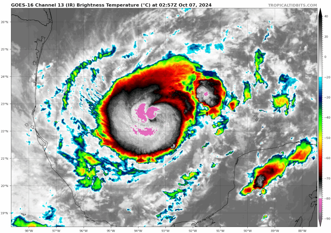
I'm not sure if there was some dry air eroding the northern half of the CDO during this loop or just convection waning, but the recent bursts should fence that off.
A more recent VDM just came in with a closed, ragged eyewall:
A more recent VDM just came in with a closed, ragged eyewall:
048
URNT12 KNHC 070459
VORTEX DATA MESSAGE AL142024
A. 07/04:37:50Z
B. 22.23 deg N 093.13 deg W
C. 700 mb 2909 m
D. 977 mb
E. 070 deg 17 kt
F. CLOSED
G. E27/30/20
H. 65 kt
I. 303 deg 8 nm 04:35:30Z
J. 047 deg 65 kt
K. 310 deg 10 nm 04:35:00Z
L. 63 kt
M. 017 deg 7 nm 04:40:30Z
N. 102 deg 64 kt
O. 013 deg 9 nm 04:41:00Z
P. 10 C / 3061 m
Q. 16 C / 3051 m
R. 12 C / NA
S. 12345 / 7
T. 0.02 / 2 nm
U. AF302 0514A MILTON OB 38
MAX FL WIND 71 KT 221 / 16 NM 03:14:00Z
RAGGED EYEWALL
;
2 likes
TC naming lists: retirements and intensity
Most aggressive Advisory #1's in North Atlantic (cr. kevin for starting the list)
Most aggressive Advisory #1's in North Atlantic (cr. kevin for starting the list)
-
cheezyWXguy
- Category 5
- Posts: 6280
- Joined: Mon Feb 13, 2006 12:29 am
- Location: Dallas, TX
Re: ATL: MILTON - Hurricane - Discussion
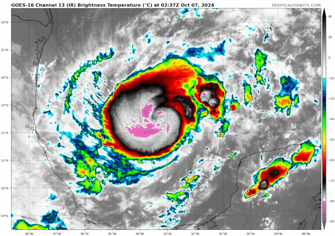
Teban54 wrote:I'm not sure if there was some dry air eroding the northern half of the CDO during this loop or just convection waning, but the recent bursts should fence that off.
https://i.postimg.cc/285wdBqH/goes16-ir-14-L-202410070237.gif
A more recent VDM just came in with a closed, ragged eyewall:048
URNT12 KNHC 070459
VORTEX DATA MESSAGE AL142024
A. 07/04:37:50Z
B. 22.23 deg N 093.13 deg W
C. 700 mb 2909 m
D. 977 mb
E. 070 deg 17 kt
F. CLOSED
G. E27/30/20
H. 65 kt
I. 303 deg 8 nm 04:35:30Z
J. 047 deg 65 kt
K. 310 deg 10 nm 04:35:00Z
L. 63 kt
M. 017 deg 7 nm 04:40:30Z
N. 102 deg 64 kt
O. 013 deg 9 nm 04:41:00Z
P. 10 C / 3061 m
Q. 16 C / 3051 m
R. 12 C / NA
S. 12345 / 7
T. 0.02 / 2 nm
U. AF302 0514A MILTON OB 38
MAX FL WIND 71 KT 221 / 16 NM 03:14:00Z
RAGGED EYEWALL
;
Whatever the issue, it’s gone now. IR presentation really improving now.
2 likes

Re: ATL: MILTON - Hurricane - Discussion
Noticed the ragged northern semicircle too. That blob to the east that was predicted has started and may be along for the ride for Milton's Journey across the GOM!
0 likes
-
ElectricStorm

- Category 5
- Posts: 5125
- Age: 25
- Joined: Tue Aug 13, 2019 11:23 pm
- Location: Norman, OK
Re: ATL: MILTON - Hurricane - Discussion
cheezyWXguy wrote:Teban54 wrote:I'm not sure if there was some dry air eroding the northern half of the CDO during this loop or just convection waning, but the recent bursts should fence that off.
https://i.postimg.cc/285wdBqH/goes16-ir-14-L-202410070237.gif
A more recent VDM just came in with a closed, ragged eyewall:048
URNT12 KNHC 070459
VORTEX DATA MESSAGE AL142024
A. 07/04:37:50Z
B. 22.23 deg N 093.13 deg W
C. 700 mb 2909 m
D. 977 mb
E. 070 deg 17 kt
F. CLOSED
G. E27/30/20
H. 65 kt
I. 303 deg 8 nm 04:35:30Z
J. 047 deg 65 kt
K. 310 deg 10 nm 04:35:00Z
L. 63 kt
M. 017 deg 7 nm 04:40:30Z
N. 102 deg 64 kt
O. 013 deg 9 nm 04:41:00Z
P. 10 C / 3061 m
Q. 16 C / 3051 m
R. 12 C / NA
S. 12345 / 7
T. 0.02 / 2 nm
U. AF302 0514A MILTON OB 38
MAX FL WIND 71 KT 221 / 16 NM 03:14:00Z
RAGGED EYEWALL
;
Whatever the issue, it’s gone now. IR presentation really improving now.
Of course it's right after recon leaves
1 likes
B.S Meteorology, University of Oklahoma '25
Please refer to the NHC, NWS, or SPC for official information.
Please refer to the NHC, NWS, or SPC for official information.
-
karenfromheaven

- Tropical Storm

- Posts: 171
- Age: 71
- Joined: Thu Sep 09, 2004 4:45 pm
- Location: North Naples, FL
Re: ATL: MILTON - Hurricane - Discussion
bohai wrote:Has anyone seen a recent SHIPS forecast or know where to find one? Also is there a SLOSH model available to te public? Stay safe Floridians.
Worse case surge, read it and weep....https://www.nhc.noaa.gov/refresh/graphics_at4+shtml/032733.shtml?inundation#contents
1 likes
Who is online
Users browsing this forum: No registered users and 14 guests