ATL: MILTON - Models
Moderator: S2k Moderators
Re: ATL: MILTON - Models
Shift south.


0 likes
The following post is NOT an official forecast and should not be used as such. It is just the opinion of the poster and may or may not be backed by sound meteorological data. It is NOT endorsed by any professional institution including storm2k.org For Official Information please refer to the NHC and NWS products.
Re: ATL: MILTON - Models
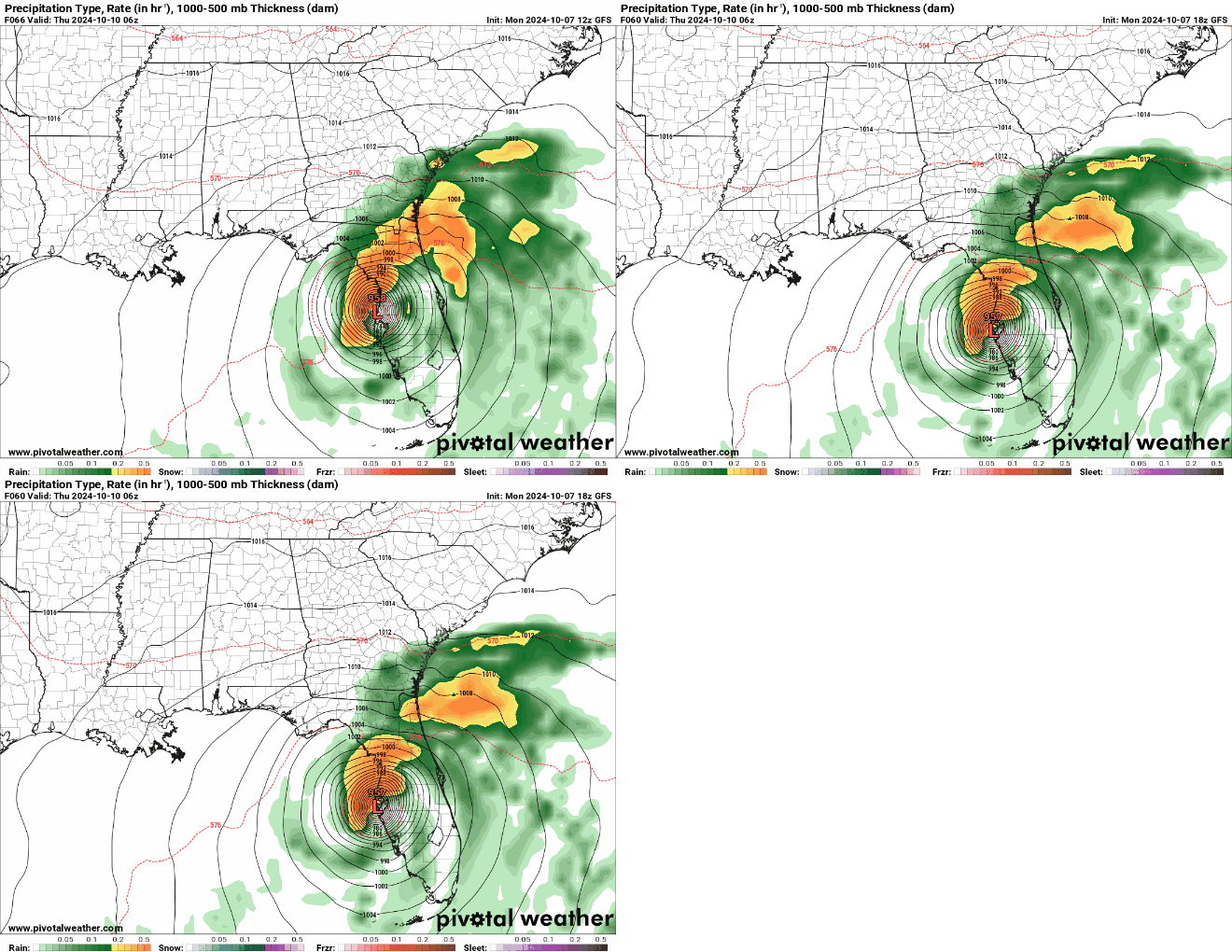
someone will have better resolution but Tampa area landfall as a strengthening hurricane at 63 hours and then exits around Daytona (so more NE than E like Icon) 9 hours later
0 likes
Just like Jon Snow..."I know nothing" except what I know, and most of what I know is gathered by the fine people of the NHC
Re: ATL: MILTON - Models
Trending further south last three runs.


1 likes
The following post is NOT an official forecast and should not be used as such. It is just the opinion of the poster and may or may not be backed by sound meteorological data. It is NOT endorsed by any professional institution including storm2k.org For Official Information please refer to the NHC and NWS products.
Re: ATL: MILTON - Models
So it turns out those most extreme runs of the HAFS model were right...
4 likes
-
MEANINGLESS_NUMBERS
- Category 2

- Posts: 503
- Joined: Mon Nov 02, 2020 1:43 pm
Re: ATL: MILTON - Models
blp wrote:Trending further south last three runs.
https://i.ibb.co/dGWdbRk/16519797-3a2b-4349-b751-346fb5945dcf.gif
Zeroing in on Tampa. This could be the most costly hurricane in US history.
2 likes
Emily '87, Felix '95, Gert '99, Fabian '03, Humberto '19, Paulette '20, Teddy '20, Fiona '22, Lee '23, Ernesto '24, Humberto/Imelda '25
Re: ATL: MILTON - Models
kevin wrote:So it turns out those most extreme runs of the HAFS model were right...
12z HAFS-B nailed Milton’s intensity.
1 likes
Irene '11 Sandy '12 Hermine '16 5/15/2018 Derecho Fay '20 Isaias '20 Elsa '21 Henri '21 Ida '21
I am only a meteorology enthusiast who knows a decent amount about tropical cyclones. Look to the professional mets, the NHC, or your local weather office for the best information.
I am only a meteorology enthusiast who knows a decent amount about tropical cyclones. Look to the professional mets, the NHC, or your local weather office for the best information.
Re: ATL: MILTON - Models
Secret_Meteorologist wrote:aspen wrote:kevin wrote:So it turns out those most extreme runs of the HAFS model were right...
12z HAFS-B nailed Milton’s intensity.
If this is the case, we should also consider the HAFS-B has it weakening significantly (to 964mb) prior to landfall. Which would be great news for all.
Still a Cat. 3 and surge of Cat. 5 if North of the bay.
2 likes
Re: ATL: MILTON - Models
Secret_Meteorologist wrote:aspen wrote:kevin wrote:So it turns out those most extreme runs of the HAFS model were right...
12z HAFS-B nailed Milton’s intensity.
If this is the case, we should also consider the HAFS-B has it weakening significantly (to 964mb) prior to landfall. Which would be great news for all.
Still a Cat 3 at landfall with expanded hurricane force winds with a large storm surge. Not that great news.
3 likes
- ElectricStorm
- Category 5

- Posts: 5144
- Age: 25
- Joined: Tue Aug 13, 2019 11:23 pm
- Location: Norman, OK
Re: ATL: MILTON - Models
Hurricane Milton Intermediate Advisory Number 11A
NWS National Hurricane Center Miami FL AL142024
700 PM CDT Mon Oct 07 2024
...CENTRAL PRESSURE IN THE EYE OF MILTON HAS FALLEN TO A NEAR RECORD
LOW...
...MILTON POSES AN EXTREMELY SERIOUS THREAT TO FLORIDA AND
RESIDENTS ARE URGED TO FOLLOW THE ORDERS OF LOCAL OFFICIALS...
SUMMARY OF 700 PM CDT...0000 UTC...INFORMATION
----------------------------------------------
LOCATION...21.9N 90.4W
ABOUT 60 MI...100 KM NW OF PROGRESO MEXICO
ABOUT 650 MI...1045 KM SW OF TAMPA FLORIDA
MAXIMUM SUSTAINED WINDS...180 MPH...285 KM/H
PRESENT MOVEMENT...E OR 90 DEGREES AT 10 MPH...17 KM/H
MINIMUM CENTRAL PRESSURE...897 MB...26.49 INCHES
Glad to see them go with the 897 to make it official before the weakening trend
0 likes
B.S Meteorology, University of Oklahoma '25
Please refer to the NHC, NWS, or SPC for official information.
Please refer to the NHC, NWS, or SPC for official information.
- SouthFLTropics
- Category 5

- Posts: 4258
- Age: 50
- Joined: Thu Aug 14, 2003 8:04 am
- Location: Port St. Lucie, Florida
Re: ATL: MILTON - Models
Anyone have access to the 18z hurricane models. TT is obviously getting bombed and the servers aren't handling it.
0 likes
Fourth Generation Florida Native
Personal Storm History: David 79, Andrew 92, Erin 95, Floyd 99, Irene 99, Frances 04, Jeanne 04, Wilma 05, Matthew 16, Irma 17, Ian 22, Nicole 22, Milton 24
Personal Storm History: David 79, Andrew 92, Erin 95, Floyd 99, Irene 99, Frances 04, Jeanne 04, Wilma 05, Matthew 16, Irma 17, Ian 22, Nicole 22, Milton 24
- Stormgodess
- Category 1

- Posts: 316
- Joined: Mon Sep 14, 2020 1:31 am
Re: ATL: MILTON - Models
Is it skirting the coast moving North in that clip? Or is that two different models?
Please explain like I'm a 5 yr old
0 likes
Re: ATL: MILTON - Models
SouthFLTropics wrote:Anyone have access to the 18z hurricane models. TT is obviously getting bombed and the servers aren't handling it.
Yeah TTs servers must be overloaded. NHC was down earlier today. Can't imagine the traffic on both those sites today.
1 likes
- Bocadude85
- Category 5

- Posts: 2991
- Age: 39
- Joined: Mon Apr 18, 2005 2:20 pm
- Location: Honolulu,Hi
Re: ATL: MILTON - Models
SouthFLTropics wrote:Anyone have access to the 18z hurricane models. TT is obviously getting bombed and the servers aren't handling it.
HAFS-A is right up the mouth of Tampa Bay, HAFS-B is into St. Pete. HMON into Tarpon Springs. HWRF is New Port Richey.
Last edited by Bocadude85 on Mon Oct 07, 2024 7:34 pm, edited 2 times in total.
1 likes
Re: ATL: MILTON - Models
caneman wrote:Steve wrote:Secret_Meteorologist wrote:
... That's precisely what I'm saying. The forecast is for a weakening trend prior to landfall. That is one positive trend here which I think is under-highlighted on this forum. The NHC supports this. I did not attempt to contradict that in any way. Trust the experts - I support this. I was simply highlighting said positive trend in the regional models, supported with data from a model you spoke highly of and stating I hope this continued. It was a positive post. You turned it negative. I'll move on. Best of luck to you. I want everyone to be safe. Stay safe!
If it comes up into the shear it’s one thing. But the loop current and near-coast heat are both warm anomalies. So that somewhat mitigates extreme weakening. We will see if it peaks out tomorrow afternoon which I’m betting is likely. After that, ? 940’s is still a strong ass 3.
Plus up to 12 foot surge. After seeing surge 1st hand i really don't think most people get it. Shoot, I've been following these for 25 years and I didn't get it til Helene and actually seeing it flood 3 or 3 houses down from me!!!
Been since 69 for me as a wee little kid. But it’s not just the surge. We all know wind is strongest over water because of the lack of friction. So we got a couple extra feet of waves even though inside the bay it’ll be more chops than rolling waves they’ll see at the coast.
2 likes
Re: ATL: MILTON - Models
18Z GFS appears to be a decent jump S. I’m on mobile so hard to post. But seems a good clip S of 12Z. May be first GFS run with landfall south of Tampa.
Last edited by fllawyer on Mon Oct 07, 2024 7:37 pm, edited 2 times in total.
1 likes
-
BIFF_THE_UNRULY
- Tropical Storm

- Posts: 143
- Joined: Fri Jun 28, 2024 2:12 pm
Re: ATL: MILTON - Models
Stormgodess wrote:
Is it skirting the coast moving North in that clip? Or is that two different models?
Please explain like I'm a 5 yr old
models are coming into agreement Tampa is gonna be hit
0 likes
- DESTRUCTION5
- Category 5

- Posts: 4430
- Age: 44
- Joined: Wed Sep 03, 2003 11:25 am
- Location: Stuart, FL
Re: ATL: MILTON - Models
18z Euro looks like a Sarasota to Melbourne exit..
3 likes
GATOR NATION IS E V E R Y W H E R E !
Re: ATL: MILTON - Models
DESTRUCTION5 wrote:18z Euro looks like a Sarasota to Melbourne exit..
Can someone post the graphics for 18z Euro?
1 likes
Re: ATL: MILTON - Models
DESTRUCTION5 wrote:18z Euro looks like a Sarasota to Melbourne exit..
Can someone post the link or run?
1 likes
Who is online
Users browsing this forum: No registered users and 3 guests


