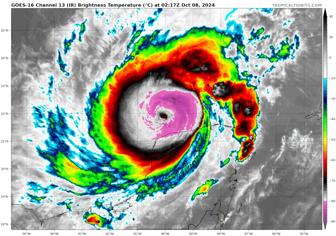
ATL: MILTON - Post-Tropical - Discussion

Moderator: S2k Moderators

Message
Author
User avatar
Stormgodess
Category 1
Category 1
Posts: 301
Joined: Mon Sep 14, 2020 1:31 am

Re: ATL: MILTON - Hurricane - Discussion

#2861 Postby Stormgodess » Tue Oct 08, 2024 12:00 am

Teban54 wrote:Even during EWRC, Milton still wants to keep the -80C ring.

https://i.postimg.cc/nzZqPcJr/goes16-ir-14-L-202410080217.gif


Geez Scorpion reef is getting pounded right now. I realize it's uninhabited, but wonder what sort of ecological damage a storm like this could do to it?
0 likes   

User avatar
ElectricStorm
Category 5
Category 5
Posts: 5061
Age: 24
Joined: Tue Aug 13, 2019 11:23 pm
Location: Skiatook, OK / Norman, OK

Re: ATL: MILTON - Hurricane - Discussion

#2862 Postby ElectricStorm » Tue Oct 08, 2024 12:01 am

Up to 924mb on eye drop. May see it rise a little more until ERC is done (which looking at the recon graph should be very soon). Thinking this could get close to what it was today, just with a larger eye and maybe slightly higher pressure (but still very low)
1 likes   
B.S Meteorology, University of Oklahoma '25

Please refer to the NHC, NWS, or SPC for official information.

User avatar
Stormgodess
Category 1
Category 1
Posts: 301
Joined: Mon Sep 14, 2020 1:31 am

Re: ATL: MILTON - Hurricane - Discussion

#2863 Postby Stormgodess » Tue Oct 08, 2024 12:01 am

Poonwalker wrote:I had wondered what life would be like to build a house on scorpion key. Get up early every day and fish the most pristine and remote places on earth. Right now that would be a living hell.


That GIF made you think of the exact same thing it did me
1 likes   

User avatar
ConvergenceZone
Category 5
Category 5
Posts: 5194
Joined: Fri Jul 29, 2005 1:40 am
Location: Northern California

Re: ATL: MILTON - Hurricane - Discussion

#2864 Postby ConvergenceZone » Tue Oct 08, 2024 12:04 am

I just noticed the latest NHC discussion doesn't show any more intensification at this point. I thought it would show it for tomorrow after the EWRC, but I guess not.
1 likes   

canetoad
Tropical Wave
Tropical Wave
Posts: 5
Joined: Mon Oct 07, 2024 10:09 pm

Re: ATL: MILTON - Hurricane - Discussion

#2865 Postby canetoad » Tue Oct 08, 2024 12:04 am

Keldeo1997 wrote:Recon reports that the EWRC is done. Just one 16nm EW.


is this just recency bias on my part or is that uncommonly fast for an EWRC? I guess it makes sense given how small it was initially but that seems like an unusually rapid completion even under the circumstances
1 likes   

Sciencerocks
Category 5
Category 5
Posts: 9162
Age: 39
Joined: Thu Jul 06, 2017 1:51 am

Re: ATL: MILTON - Hurricane - Discussion

#2866 Postby Sciencerocks » Tue Oct 08, 2024 12:05 am

Sciencerocks wrote:Based on latest recon the pressure is in the lower 920's with flight level winds in the 120's knts and smrf is 135 knts. I'd go around 130 knts.


I am 1. leaning heavily on smrf and 2. consistency as the ewrc is over and restrengthening will happen soon. If one would go by flight level alone between the two passes this is probably 110-115 knots. This is based on pass 1.128 knots earlier pass and 121 knots flight level in the one that just happened.
Last edited by Sciencerocks on Tue Oct 08, 2024 12:07 am, edited 1 time in total.
1 likes   

User avatar
Teban54
Category 5
Category 5
Posts: 3208
Joined: Sat May 19, 2018 1:19 pm

Re: ATL: MILTON - Hurricane - Discussion

#2867 Postby Teban54 » Tue Oct 08, 2024 12:05 am

ConvergenceZone wrote:I just noticed the latest NHC discussion doesn't show any more intensification at this point. I thought it would show it for tomorrow after the EWRC, but I guess not.

IIRC, it's actually more common than you might think for second and third peaks to not be forecast by NHC in advance. This certainly applied to Lorenzo's 2nd peak (Cat 5) and Sam's impressive 3rd peak.
1 likes   

404UserNotFound
Tropical Depression
Tropical Depression
Posts: 60
Joined: Sun Dec 01, 2013 6:21 pm
Location: Near Antipodes of Crozet Islands

Re: ATL: MILTON - Hurricane - Discussion

#2868 Postby 404UserNotFound » Tue Oct 08, 2024 12:12 am

It is time for our legally mandated humor break.

Oh... boy. First Florida had to wrestle with Helene-a-cell, and even though forecasters had Cena coming days in advance, her finishing move was to slam those further north with floodwaters reaching the top rope, leaving people caught between The Rock and a hard place, especially for those whose windows weren't already made from Suplexiglas. Now, we have Hurricane Stilton—I mean, Milton—threatening to, once again, whip up the debrie left behind. Not a Gouda situation, even for places as far south as Cape Romano. By now, Americans living on the Gulf coast of Florida have got to be feta up with these Muensterous hurricanes repeatedly destroying their cottages and leaving them with Monterey Jack squat. Alas, if you're in the path, it is again time to sound the sirenes, evacuate the area in an ordaly fashion, and hope for the storm to mish where you live, for it's just nacho day today....

This has been our legally mandated humor break; we now return to our scheduled Hurricane Stilton Milton programming. Dave, you weren't supposed to let the humor leak into the serious broadcast! What do you think you're doing, Dave!? If I had my way with you, I would—oh, did Dave leave the mic on again? Dave, you idiot! You're supposed to—
5 likes   
Please note: Never take any statements I make about forecasts at face value, as I am nowhere near professional at that.

User avatar
Stormgodess
Category 1
Category 1
Posts: 301
Joined: Mon Sep 14, 2020 1:31 am

Re: ATL: MILTON - Hurricane - Discussion

#2869 Postby Stormgodess » Tue Oct 08, 2024 12:20 am

404UserNotFound wrote:It is time for our legally mandated humor break.

Oh... boy. First Florida had to wrestle with Helene-a-cell, and even though forecasters had Cena coming days in advance, her finishing move was to slam those further north with floodwaters reaching the top rope, leaving people caught between The Rock and a hard place, especially for those whose windows weren't already made from Suplexiglas. Now, we have Hurricane Stilton—I mean, Milton—threatening to, once again, whip up the debrie left behind. Not a Gouda situation, even for places as far south as Cape Romano. By now, Americans living on the Gulf coast of Florida have got to be feta up with these Muensterous hurricanes repeatedly destroying their cottages and leaving them with Monterey Jack squat. Alas, if you're in the path, it is again time to sound the sirenes, evacuate the area in an ordaly fashion, and hope for the storm to mish where you live, for it's just nacho day today....

This has been our legally mandated humor break; we now return to our scheduled Hurricane Stilton Milton programming. Dave, you weren't supposed to let the humor leak into the serious broadcast! What do you think you're doing, Dave!? If I had my way with you, I would—oh, did Dave leave the mic on again? Dave, you idiot! You're supposed to—


That was Cheesy! :hmm:
2 likes   

User avatar
cheezyWXguy
Category 5
Category 5
Posts: 6108
Joined: Mon Feb 13, 2006 12:29 am
Location: Dallas, TX

Re: ATL: MILTON - Hurricane - Discussion

#2870 Postby cheezyWXguy » Tue Oct 08, 2024 12:22 am

Ok so I’m just gonna go on record and say I don’t think that Milton was at peak intensity when recon got back into it this afternoon. Normally I would agree with the logic that it it was at peak due to the lack of a secondary eyewall on the first pass, but after reviewing the satellite loops, there are a couple of things that stand out to me.
1. After about 330pm cdt, the eye began to constrict at an accelerated rate, as opposed to the gradual rate it had over the several hours prior. While eye constriction is typically a sign of intensification, I’ve noticed that a sudden increase in the rate of this constriction is often associated with weakening. Granted, this is just my personal thought, but I have observed this to be the case with Lee last year and Beryl this year.
2. The sudden appearance of -80c cloud tops that immediately followed from 4pm cdt or so onward coincided with the lowering of the sun angle and increased as night fell. I think the lowering of the sun partially explains the cooler cloud temps, and partially explained by the next factor, but not by apparent intensification.
3. Around the time of the two factors above, Milton’s core began to parallel the northern coast of the Yucatán. I have a strong suspicion that frictional affects played a role in leveling off and subsequently reversing the intensification phase, and may be the reason why Milton went from virtually no evidence of an EWRC on recon FL data, to showing a distinct secondary wind maximum within one pass. I think the flat SW to NE edge of convection observed over the last several hours on the SE side of the storm (the portion of the storm that is currently over the Yucatán) is evidence for these frictional affects.

TLDR - I think Milton peaked around 230-3pm cdt, and began to level off and then weaken at an accelerating rate due to frictional effects from the Yucatán. I also think it was likely the impetus for the rapid onset onset of secondary eyewall formation. Open to discussion or being disproven, but these are my thoughts at the moment.
7 likes   

Sciencerocks
Category 5
Category 5
Posts: 9162
Age: 39
Joined: Thu Jul 06, 2017 1:51 am

Re: ATL: MILTON - Hurricane - Discussion

#2871 Postby Sciencerocks » Tue Oct 08, 2024 12:30 am

cheezyWXguy wrote:Ok so I’m just gonna go on record and say I don’t think that Milton was at peak intensity when recon got back into it this afternoon. Normally I would agree with the logic that it it was at peak due to the lack of a secondary eyewall on the first pass, but after reviewing the satellite loops, there are a couple of things that stand out to me.
1. After about 330pm cdt, the eye began to constrict at an accelerated rate, as opposed to the gradual rate it had over the several hours prior. While eye constriction is typically a sign of intensification, I’ve noticed that a sudden increase in the rate of this constriction is often associated with weakening. Granted, this is just my personal thought, but I have observed this to be the case with Lee last year and Beryl this year.
2. The sudden appearance of -80c cloud tops that immediately followed from 4pm cdt or so onward coincided with the lowering of the sun angle and increased as night fell. I think the lowering of the sun partially explains the cooler cloud temps, and partially explained by the next factor, but not by apparent intensification.
3. Around the time of the two factors above, Milton’s core began to parallel the northern coast of the Yucatán. I have a strong suspicion that frictional affects played a role in leveling off and subsequently reversing the intensification phase, and may be the reason why Milton went from virtually no evidence of an EWRC on recon FL data, to showing a distinct secondary wind maximum within one pass. I think the flat SW to NE edge of convection observed over the last several hours on the SE side of the storm (the portion of the storm that is currently over the Yucatán) is evidence for these frictional affects.

TLDR - I think Milton peaked around 230-3pm cdt, and began to level off and then weaken at an accelerating rate due to frictional effects from the Yucatán. I also think it was likely the impetus for the rapid onset onset of secondary eyewall formation. Open to discussion or being disproven, but these are my thoughts at the moment.


Kind of like Debby 2000 as it moved north of the DR. I also suggest that the inflow of moisture was cut off that it was pulling into it from the boc by the land mass of the yucatan once it moved north of it. This caused the core to become unstable and probably also brought in drier air from off that landmass that helped in the collapse of the core.

I agree in general. Storms like Milton are very tight and small systems that can strengthen very fast but also collapse very fast...Another example is iris 2001 and danny of 2015. Doesn't take much shear or dry air to destroy their cores and cause rapid weakening.
2 likes   

gailwarning
S2K Supporter
S2K Supporter
Posts: 57
Joined: Sun Sep 10, 2017 1:09 pm
Location: N. Georgia. Sick of FL

Re: ATL: MILTON - Hurricane - Discussion: 175 mph

#2872 Postby gailwarning » Tue Oct 08, 2024 12:35 am

La Sirena wrote:
Michele B wrote:
NAVAIDNICK wrote:
My wife is the same exact way. We didn't lose everything in Ian but we lost enough for it to give her PTSD. We were also in the eye wall for 8 hours since it skirted right by us as it came through PC and by NP. We've been planning on moving to the N. GA mountains next spring. Hopefully we will be able to sell in the next 6 months. That is if anyone still wants to live in FL.


I'm hoping my house withstands this storm, which I can use as a selling point to those who think this is a wonderful place to live!

Really, it IS! Except when hurricanes threaten. I guess you pick your poison, eh?

We sold our home in Big Pine Key a month before Irma hit. Thought we dodged a bullet. Moved to southeast Alabama and Michael hit us as a Cat 3 living 86 miles inland. Then we moved back to my hometown of Hampton, Tn. We just got hit with catastrophic flooding from Helene. I had to be evacuated from our home it all happened so fast. I just feel like weather happens everywhere. No one in southern Appalachia ever thought this could happen to us. Not from a hurricane.


I moved from the Melbourne area to the North Georgia mountains near Blairsville in 2018. I was sick of the "3 Hs"- heat, humidity, and hurricanes! I don't regret it. But with Helene, it gave me quite a start to find out we were right in the crosshairs. That jog spared us and demolished WNC instead. I'm grateful but so sad for the people there. Frankly, I don't think it would have been as catastrophic here, given that we have 3 TVA flood-managed lakes that they start drawing down in late August. Our terrain is a little gentler here as well. But all this is making me re-think my life choices!
2 likes   

FLLurker32
Tropical Storm
Tropical Storm
Posts: 245
Joined: Mon Aug 29, 2016 10:31 am

Re: ATL: MILTON - Hurricane - Discussion

#2873 Postby FLLurker32 » Tue Oct 08, 2024 12:41 am

Sciencerocks wrote:
Sciencerocks wrote:Based on latest recon the pressure is in the lower 920's with flight level winds in the 120's knts and smrf is 135 knts. I'd go around 130 knts.


I am 1. leaning heavily on smrf and 2. consistency as the ewrc is over and restrengthening will happen soon. If one would go by flight level alone between the two passes this is probably 110-115 knots. This is based on pass 1.128 knots earlier pass and 121 knots flight level in the one that just happened.


Latest HAFS supports the idea of a 2nd intensity run after the ewrc.
1 likes   
Heather

gailwarning
S2K Supporter
S2K Supporter
Posts: 57
Joined: Sun Sep 10, 2017 1:09 pm
Location: N. Georgia. Sick of FL

Re: ATL: MILTON - Hurricane - Discussion: 175 mph

#2874 Postby gailwarning » Tue Oct 08, 2024 12:42 am

Aggiemon96 wrote:
ObsessedMiami wrote:As an FIU student in the time of Andrew, I took part in a big Anthropology study of the cultural effects of the storm. The amount of divorces in the six months after Andrew was astronomical.


As was, I am sure, the number of births about 9 months after.

Our daughter was a "product" of an evacuation. Indeed, Hurricane Rita ended up being extremely costly for me, despite the only physical damage of note being my fence! (No, we didn't end up naming her Rita, though we considered it for a fleeting moment or two.)


My sister, born on October 5, 1954, was indeed named Carol after Hurricane Carol in '54. She lived up to that name in her youth! :-)
Last edited by gailwarning on Tue Oct 08, 2024 1:02 am, edited 1 time in total.
0 likes   

User avatar
Beef Stew
Category 1
Category 1
Posts: 499
Joined: Sat May 30, 2020 11:31 am
Location: South Florida

Re: ATL: MILTON - Hurricane - Discussion

#2875 Postby Beef Stew » Tue Oct 08, 2024 12:42 am

Stormgodess wrote:
Teban54 wrote:Even during EWRC, Milton still wants to keep the -80C ring.

https://i.postimg.cc/nzZqPcJr/goes16-ir-14-L-202410080217.gif


Geez Scorpion reef is getting pounded right now. I realize it's uninhabited, but wonder what sort of ecological damage a storm like this could do to it?


Hey! This is a topic I’ve actually participated in research on, so I can provide a bit of insight:

In summary, truly pristine and unaltered ecosystems in the tropics tend to handle hurricane/cyclone impacts well. After all, they’ve coexisted with the most intense storms on earth for millions of years- ecosystems adapt to their environment, and frequent (on a geological time scale) intense hurricanes are one of the factors that life in the tropics has evolved to handle, and in many cases, even depend on to survive in a variety of ways (I could go more into detail here, but there are many ways the disruption of a cyclone allows for new life to flourish; similar to a forest fire clearing underbrush and allowing new growth to sprout).

Now, the huge caveat here is that very few ecosystems are truly pristine and not under duress from anthropogenic factors in modern times. While ecosystems have evolved to handle hurricanes, they haven’t evolved to handle human pollution that gets washed into them, redirected surge and run off, storm fatalities on species that are already endangered from other causes, etc.

The biggest impact in this regard for marine environments like scorpion reef is that corals throughout the Caribbean (and tropics worldwide, for that matter) are already under immense threat from both infectious disease and coral bleaching, both of which are rising in occurrence due to increased thermal stress linked to anthropogenic warming. Reefs in the Caribbean have been decimated by both disease and bleaching in recent decades- unfortunately, while they would weather storms if they were healthy, it is much, much more difficult when they’re already struggling from dramatic and unprecedented environmental changes.

I could go into much more depth with this answer, but I don’t want to get too off topic. Long-answer-short: pristine and wild places like scorpion reef can handle the impacts of hurricanes better than nearly any ecosystem on the planet, yet will still be susceptible to potentially significant ecological damage due to enhanced vulnerability from the downstream effects of anthropogenic influence that reaches even the most remote of locations.
6 likes   

gailwarning
S2K Supporter
S2K Supporter
Posts: 57
Joined: Sun Sep 10, 2017 1:09 pm
Location: N. Georgia. Sick of FL

Re: ATL: MILTON - Hurricane - Discussion: 180 mph / 897 mbs

#2876 Postby gailwarning » Tue Oct 08, 2024 12:45 am

canetoad wrote:
norva13x wrote:FEMA has a colossal task already from multiple major storms including as recently as a couple weeks ago! If anything I want to thank them and local officials for doing all they can, the scope is unimaginable right now.


I agree - to the earlier posts about FEMA not being around to clear the debris especially and the governor having to intervene and cut locks at the dump sites... in my understanding, FEMA is only ever meant to step in when the state is overwhelmed and can't handle the recovery on its own, so I don't really get the narrative that the state handling its own affairs means the feds have failed or are underperformoing. In theory, a governor setting things in motion should just be a sign of good emergency management and appropriate state budgeting, not needing as much assistance from the federal government.

I would also like to point out that "FEMA" itself is just a coordinating body, mostly. They manage the purse strings but Congrrss routinely has to replenish the oft-depleted disaster relief funds in recent years.

Most of the folks that roll in are perhaps sent by FEMA as head coordinator and funds distrubutor but it's largely a mix of deployment-ready military, first responders / swift water rescue teams, power restoration company employees, nonprofit volunteers like Salvation Army, Samaritan's Purse and the Scientologists, and locally hired contractors, with some FEMA reservists mixed in mistly to go door to door signing folks up for relief programs. The assembled apparatus is almost always an impressively massive mix of folks from all walks of life and careers, and my hat's off to all of them.

The problem in 2017 was that a lot of those folks couldn't even get out to Puerto Rico and were stretched mighty thin between Houston, Florida, the Caribbean, and the California wildfires, and I fear we might be approaching that now as well if Milton causes even half as much damage as still remains from Helene. The helpers are always there, but they're not an infinite resource and this one-two punch much be causing significant strain on the community of volunteers and professionals alike


Not to mention the 1,200 or so FEMA reps that are fully occupied in WNC. If FEMA is stretched too thin, it's Congress we need to have a word with.
3 likes   

FLLurker32
Tropical Storm
Tropical Storm
Posts: 245
Joined: Mon Aug 29, 2016 10:31 am

Re: ATL: MILTON - Hurricane - Discussion

#2877 Postby FLLurker32 » Tue Oct 08, 2024 12:49 am

At a glance, it looks like our Milton is on a more ENE movement now. Gaining a little latitude.
0 likes   
Heather

User avatar
ConvergenceZone
Category 5
Category 5
Posts: 5194
Joined: Fri Jul 29, 2005 1:40 am
Location: Northern California

Re: ATL: MILTON - Hurricane - Discussion

#2878 Postby ConvergenceZone » Tue Oct 08, 2024 12:50 am

Sciencerocks wrote:
Sciencerocks wrote:Based on latest recon the pressure is in the lower 920's with flight level winds in the 120's knts and smrf is 135 knts. I'd go around 130 knts.


I am 1. leaning heavily on smrf and 2. consistency as the ewrc is over and restrengthening will happen soon. If one would go by flight level alone between the two passes this is probably 110-115 knots. This is based on pass 1.128 knots earlier pass and 121 knots flight level in the one that just happened.


Yea, I'm guessing it's around 145 mph right now. Might drop to 135 mph by morning and then might see some slight strengthening in the late morning. Ship shows strong shear by tomorrow night as the NHC pointed out, so we will probably start to see some more rapid weakening by then.
1 likes   

User avatar
Blinhart
Category 5
Category 5
Posts: 2081
Age: 48
Joined: Thu Sep 08, 2011 3:13 pm
Location: Crowley, La.

Re: ATL: MILTON - Hurricane - Discussion

#2879 Postby Blinhart » Tue Oct 08, 2024 12:57 am

ConvergenceZone wrote:
Sciencerocks wrote:
Sciencerocks wrote:Based on latest recon the pressure is in the lower 920's with flight level winds in the 120's knts and smrf is 135 knts. I'd go around 130 knts.


I am 1. leaning heavily on smrf and 2. consistency as the ewrc is over and restrengthening will happen soon. If one would go by flight level alone between the two passes this is probably 110-115 knots. This is based on pass 1.128 knots earlier pass and 121 knots flight level in the one that just happened.


Yea, I'm guessing it's around 145 mph right now. Might drop to 135 mph by morning and then might see some slight strengthening in the late morning. Ship shows strong shear by tomorrow night as the NHC pointed out, so we will probably start to see some more rapid weakening by then.


I really doubt it will drop down to 135 anytime soon, it could be down 145, but really think 155 and will be going up to about 200 by tomorrow afternoon, and I don't see the shear starting up until Wednesday morning, hoping it gets down to 130 before landfall.
0 likes   
Personal Forecast Disclaimer:
The posts in this forum are NOT official forecast and should not be used as such. They are just the opinion of the poster and may or may not be backed by sound meteorological data. They are NOT endorsed by any professional institution or storm2k.org. For official information, please refer to the NHC and NWS products.

User avatar
ConvergenceZone
Category 5
Category 5
Posts: 5194
Joined: Fri Jul 29, 2005 1:40 am
Location: Northern California

Re: ATL: MILTON - Hurricane - Discussion

#2880 Postby ConvergenceZone » Tue Oct 08, 2024 1:00 am

Blinhart wrote:
ConvergenceZone wrote:
Sciencerocks wrote:

I am 1. leaning heavily on smrf and 2. consistency as the ewrc is over and restrengthening will happen soon. If one would go by flight level alone between the two passes this is probably 110-115 knots. This is based on pass 1.128 knots earlier pass and 121 knots flight level in the one that just happened.


Yea, I'm guessing it's around 145 mph right now. Might drop to 135 mph by morning and then might see some slight strengthening in the late morning. Ship shows strong shear by tomorrow night as the NHC pointed out, so we will probably start to see some more rapid weakening by then.


I really doubt it will drop down to 135 anytime soon, it could be down 145, but really think 155 and will be going up to about 200 by tomorrow afternoon, and I don't see the shear starting up until Wednesday morning, hoping it gets down to 130 before landfall.


Originally I also thought the shear suppose to wait until Wednesday as well but the last NHC shows that the ships show it starting in 24 hours and they put that discussion out several hours ago.
1 likes   


Return to “2024”

Who is online

Users browsing this forum: No registered users and 4 guests