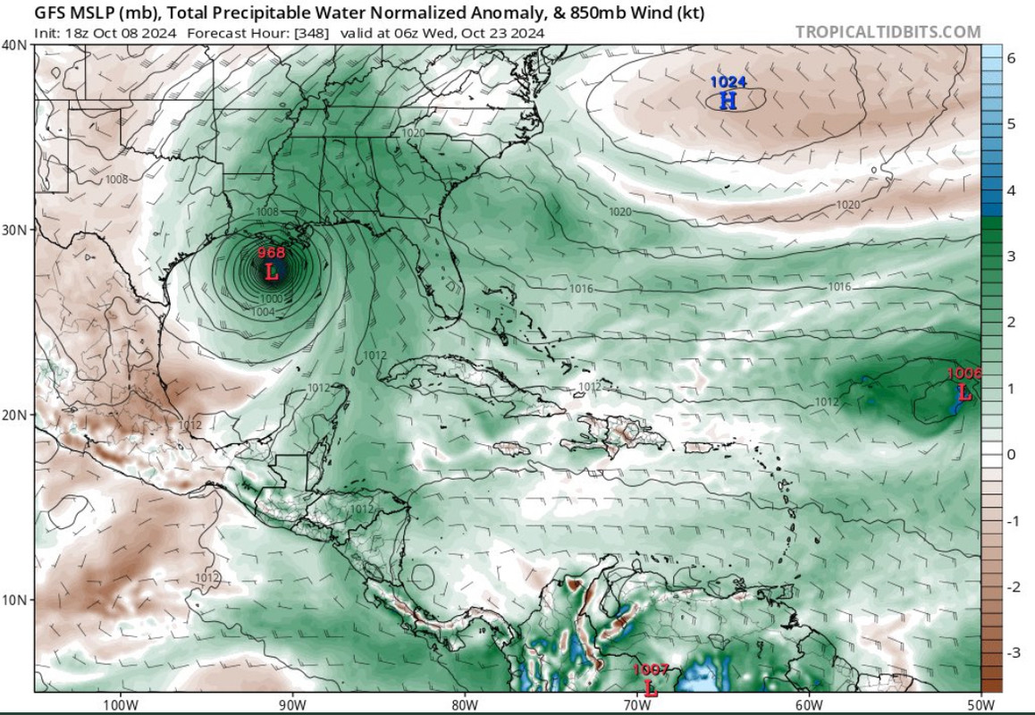
2024 Global Model Runs Discussion (Out thru day 16)

This is the general tropical discussion area. Anyone can take their shot at predicting a storms path.

Moderator: S2k Moderators

Forum rules

The posts in this forum are NOT official forecasts and should not be used as such. They are just the opinion of the poster and may or may not be backed by sound meteorological data. They are NOT endorsed by any professional institution or STORM2K. For official information, please refer to products from the National Hurricane Center and National Weather Service.

Help Support Storm2K
Message
Author
User avatar
ConvergenceZone
Category 5
Category 5
Posts: 5194
Joined: Fri Jul 29, 2005 1:40 am
Location: Northern California

Re: 2024 Global Model Runs Discussion (Out thru day 16)

#2201 Postby ConvergenceZone » Sun Oct 06, 2024 10:09 pm

toad strangler wrote:
ConvergenceZone wrote:
mantis83 wrote:12Z GFS pushes this east, well east of south florida...


Well FINALLY some good news, at least for Florida anyway.


Way too far out to take ANY individual storm location / track seriously. At that range, it’s all about signals…


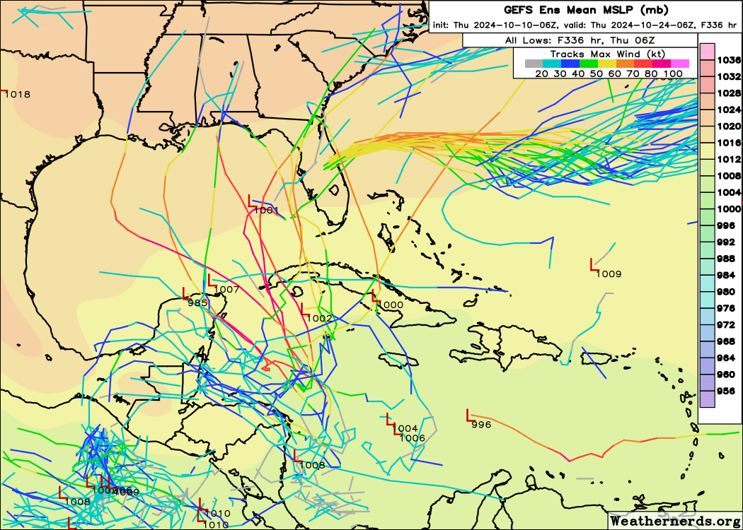
but are any other models even showing this? I keep seeing the GFS posted, but not seeing any other models posted as far as what they are showing.
0 likes   

BIFF_THE_UNRULY
Tropical Storm
Tropical Storm
Posts: 143
Joined: Fri Jun 28, 2024 2:12 pm

Re: 2024 Global Model Runs Discussion (Out thru day 16)

#2202 Postby BIFF_THE_UNRULY » Mon Oct 07, 2024 9:40 am

CrazyC83 wrote:
Category5Kaiju wrote:
BobHarlem wrote:No thanks. (To be clear this is AFTER Milton) on the 0z GFS.
https://i.imgur.com/8Oi3Zz9.png


If that happened verbatim, I honestly think there will be a mass exodus from Tampa and quite a humanitarian crisis, the likes of which I'd rather not even ruminate on at this point.


Welcome back to 2004 in Florida in that case...


No kidding. The state was seemingly cut off from the rest of the country for 20 days. It was pretty awful we were without power for a month

I remember the we boarded up for the first storm at work, took the wood down for the second, put it back up. Just decided to leave it up the rest of the year
2 likes   

User avatar
ConvergenceZone
Category 5
Category 5
Posts: 5194
Joined: Fri Jul 29, 2005 1:40 am
Location: Northern California

Re: 2024 Global Model Runs Discussion (Out thru day 16)

#2203 Postby ConvergenceZone » Mon Oct 07, 2024 10:16 am

Yea, I'm not worried about the GFS model unless other models start showing the same thing. So nothing to be concerned about at this time.
0 likes   

User avatar
Category5Kaiju
Category 5
Category 5
Posts: 4096
Joined: Thu Dec 24, 2020 12:45 pm
Location: Seattle

Re: 2024 Global Model Runs Discussion (Out thru day 16)

#2204 Postby Category5Kaiju » Mon Oct 07, 2024 7:50 pm

I think I got an aneurysm by watching the 18z GFS. This season really hates Florida.
4 likes   
Unless explicitly stated, all info in my posts is based on my own opinions and observations. Tropical storms and hurricanes can be extremely dangerous. Do not think you can beat Mother Nature. Refer to an accredited weather research agency or meteorologist if you need to make serious decisions regarding an approaching storm.

Hurricane Mike
Category 2
Category 2
Posts: 644
Joined: Tue Apr 10, 2018 7:44 am

Re: 2024 Global Model Runs Discussion (Out thru day 16)

#2205 Postby Hurricane Mike » Mon Oct 07, 2024 10:30 pm

I wouldn't rule it out. This seems like a backloaded season.
1 likes   

User avatar
kevin
Category 5
Category 5
Posts: 2586
Age: 26
Joined: Wed Aug 28, 2019 4:35 am

Re: 2024 Global Model Runs Discussion (Out thru day 16)

#2206 Postby kevin » Tue Oct 08, 2024 3:39 am

If the GEFS is to be believed the WCar could be the hotbed for TC activity in the next 2 weeks with a cluster of members forming a TC in 6 - 7 days which could impact Cuba. In the 10 - 15 day range multiple GEFS members show another WCar disturbance with US landfalling potential as well as a forming TC in the eastern part of the Caribbean. Unfortunately, SSTs in the Caribbean are at a record-high and we all know what happens when there is just too much heat energy in an unstable system (aka Milton). Unfortunately, these late season storms are almost always a threat to land. On the flip side, the GEFS also shows some out to sea MDR members, which would be a lot more fun to track. Either way, welcome to peak season 2024.
2 likes   

jconsor
Professional-Met
Professional-Met
Posts: 551
Joined: Mon Jun 30, 2008 9:31 pm
Location: Jerusalem, Israel
Contact:

Re: 2024 Global Model Runs Discussion (Out thru day 16)

#2207 Postby jconsor » Tue Oct 08, 2024 11:24 am

More potential activity in the Caribbean in mid to late Oct:

https://x.com/yconsor/status/1843674117427663154
3 likes   

User avatar
cycloneye
Admin
Admin
Posts: 145299
Age: 68
Joined: Thu Oct 10, 2002 10:54 am
Location: San Juan, Puerto Rico

Re: 2024 Global Model Runs Discussion (Out thru day 16)

#2208 Postby cycloneye » Tue Oct 08, 2024 12:40 pm

Guess what, what GFS has developing on long range is from the wave now with 20%. Look closely. :D
0 likes   
Visit the Caribbean-Central America Weather Thread where you can find at first post web cams,radars
and observations from Caribbean basin members Click Here

zzzh
Category 3
Category 3
Posts: 834
Joined: Thu Sep 02, 2021 1:13 pm

Re: 2024 Global Model Runs Discussion (Out thru day 16)

#2209 Postby zzzh » Tue Oct 08, 2024 1:39 pm

Watch for a wave entering the Caribbean near day 10, EPS has some signals.
2 likes   

LAF92
Tropical Depression
Tropical Depression
Posts: 51
Joined: Fri Aug 18, 2023 6:27 pm

Re: 2024 Global Model Runs Discussion (Out thru day 16)

#2210 Postby LAF92 » Tue Oct 08, 2024 6:35 pm

zzzh wrote:Watch for a wave entering the Caribbean near day 10, EPS has some signals.

18z GFS has a 965mb hurricane hitting the Yucatan in about 11 days then heading into the central gulf
Image
1 likes   

User avatar
ConvergenceZone
Category 5
Category 5
Posts: 5194
Joined: Fri Jul 29, 2005 1:40 am
Location: Northern California

Re: 2024 Global Model Runs Discussion (Out thru day 16)

#2211 Postby ConvergenceZone » Tue Oct 08, 2024 8:07 pm

LAF92 wrote:
zzzh wrote:Watch for a wave entering the Caribbean near day 10, EPS has some signals.

18z GFS has a 965mb hurricane hitting the Yucatan in about 11 days then heading into the central gulf
[url]https://i.postimg.cc/PrqJTNND/IMG-1654.jpg [/url]


crap. I hope not. Here we go again.
0 likes   

zzzh
Category 3
Category 3
Posts: 834
Joined: Thu Sep 02, 2021 1:13 pm

Re: 2024 Global Model Runs Discussion (Out thru day 16)

#2212 Postby zzzh » Tue Oct 08, 2024 8:10 pm

LAF92 wrote:
zzzh wrote:Watch for a wave entering the Caribbean near day 10, EPS has some signals.

18z GFS has a 965mb hurricane hitting the Yucatan in about 11 days then heading into the central gulf
[url]https://i.postimg.cc/PrqJTNND/IMG-1654.jpg [/url]

That's a different system, seems like a GFS W. Caribbean bias storm.
0 likes   

User avatar
Teban54
Category 5
Category 5
Posts: 3204
Joined: Sat May 19, 2018 1:19 pm

Re: 2024 Global Model Runs Discussion (Out thru day 16)

#2213 Postby Teban54 » Wed Oct 09, 2024 10:28 pm

GFS and Euro ensembles both have some signal for Caribbean development around Oct 18-20, although the signal on EPS is very, very weak. It appears to be the same system that operational GFS has been showing.

Thankfully, so far these models keep it weak. On the other hand, they also said so for Milton a few days before it bombed out to 897 mb.

Edit: 6z GEFS also had a few isolated members showing a west-moving MDR storm either entering the Caribbean or just to the north, but no other runs had them.
1 likes   

User avatar
weeniepatrol
Category 5
Category 5
Posts: 1273
Joined: Sat Aug 22, 2020 5:30 pm
Location: WA State

Re: 2024 Global Model Runs Discussion (Out thru day 16)

#2214 Postby weeniepatrol » Thu Oct 10, 2024 1:59 am

Presented without comment

Image
7 likes   

User avatar
Meteorcane
Category 2
Category 2
Posts: 559
Joined: Thu Jul 21, 2011 6:49 am
Location: North Platte Nebraska

Re: 2024 Global Model Runs Discussion (Out thru day 16)

#2215 Postby Meteorcane » Thu Oct 10, 2024 9:06 am

weeniepatrol wrote:Presented without comment

https://i.imgur.com/wRoM3Cj.png


GFS/GEFS still relatively insistent on some NW Carib development late next week on the tail end of a cold frontal passage (the first one of the season that really makes it through the entire GOM with some force). This is a scenario where you can get some (initially) hybrid development (which later turns fully tropical as the front washes out and upper lvl winds decrease). However, given the GFS bias for spawning gyre systems in that region would like to see some other guidance jump on board (beyond a handful of EPS members) before taking it too seriously, although it is a region that does become climo favored by late October.
1 likes   

underthwx
Category 5
Category 5
Posts: 2360
Joined: Sat Jul 30, 2011 2:14 pm
Location: Brazoria County Texas

Re: 2024 Global Model Runs Discussion (Out thru day 16)

#2216 Postby underthwx » Thu Oct 10, 2024 9:29 am

toad strangler wrote:
ConvergenceZone wrote:
mantis83 wrote:12Z GFS pushes this east, well east of south florida...


Well FINALLY some good news, at least for Florida anyway.


Way too far out to take ANY individual storm location / track seriously. At that range, it’s all about signals…

So....after reading posts here about more possible development in the NW Carribean....will this become an area of interest be highlighted by the NHC in the next few days...on their tropical cyclone outlook?...it would unfortunately not be too surprising....given the fact that it's still hurricane season...
0 likes   

User avatar
Teban54
Category 5
Category 5
Posts: 3204
Joined: Sat May 19, 2018 1:19 pm

Re: 2024 Global Model Runs Discussion (Out thru day 16)

#2217 Postby Teban54 » Thu Oct 10, 2024 10:31 am

6z GEFS has a few more members showing a strong hurricane crossing near the Yucatan Channel.

Please, can we just don't?

Image
1 likes   

User avatar
SFLcane
S2K Supporter
S2K Supporter
Posts: 10163
Age: 47
Joined: Sat Jun 05, 2010 1:44 pm
Location: Lake Worth Florida

Re: 2024 Global Model Runs Discussion (Out thru day 16)

#2218 Postby SFLcane » Thu Oct 10, 2024 10:39 am

GFS has been VERY persistent with the idea of another TC in the caribbean. Looks like a pretty classsic FL pattern.

Image

Image
2 likes   

jlauderdal
S2K Supporter
S2K Supporter
Posts: 7182
Joined: Wed May 19, 2004 5:46 am
Location: NE Fort Lauderdale
Contact:

Re: 2024 Global Model Runs Discussion (Out thru day 16)

#2219 Postby jlauderdal » Thu Oct 10, 2024 10:53 am

SFLcane wrote:GFS has been VERY persistent with the idea of another TC in the caribbean. Looks like a pretty classsic FL pattern.

https://i.postimg.cc/J7JZXyGg/gggg33.png

https://i.postimg.cc/xCNHt8gX/bbbb.jpg

Plenty of OHC to work with in that area of the basin. Will let GCANE do his thing as we get closer in. How did you do with Milt?
1 likes   

jlauderdal
S2K Supporter
S2K Supporter
Posts: 7182
Joined: Wed May 19, 2004 5:46 am
Location: NE Fort Lauderdale
Contact:

Re: 2024 Global Model Runs Discussion (Out thru day 16)

#2220 Postby jlauderdal » Thu Oct 10, 2024 10:57 am

underthwx wrote:
toad strangler wrote:
ConvergenceZone wrote:

Well FINALLY some good news, at least for Florida anyway.


Way too far out to take ANY individual storm location / track seriously. At that range, it’s all about signals…

So....after reading posts here about more possible development in the NW Carribean....will this become an area of interest be highlighted by the NHC in the next few days...on their tropical cyclone outlook?...it would unfortunately not be too surprising....given the fact that it's still hurricane season...

Might need to get a bit more support but I suspect they will be aggressive tagging, the modeling has done will with genesis during this uptick. Anyone dare go against the HAFS intensities the rest of the way?
2 likes   


Return to “Talkin' Tropics”

Who is online

Users browsing this forum: Ulf and 20 guests