
Can someone help me. I think on this site during Helene someone posted a link to a web page that showed the wind/projected wind for your location.
Does anyone remember or know that link? Thanks.
ABC Tampa was showing the shear and landfall projected south of Tampa Bay but up to 14" of rain in the north parts of the storm as it moves across.
ATL: MILTON - Post-Tropical - Discussion
Moderator: S2k Moderators
-
Meteorcane

- Category 2

- Posts: 559
- Joined: Thu Jul 21, 2011 6:49 am
- Location: North Platte Nebraska
Re: ATL: MILTON - Hurricane - Discussion: 165 mph / 902 mbs
Good time for an EWRC, hopefully it damages the structure enough to prevent any strengthening and results in modest weakening while it passes over the loop current tonight into early tomorrow morning. Then add the increase in shear onto that later tomorrow and you get the rapid weakening depicted by the hurricane models up to landfall. Still quite concerning from a surge standpoint for SW and west-central Florida, regardless of how much the winds weaken.
2 likes
-
Poonwalker
- Category 1

- Posts: 270
- Joined: Tue Sep 20, 2022 11:12 am
Re: ATL: MILTON - Hurricane - Discussion: 165 mph / 902 mbs
tiger_deF wrote:The good news throughout this is that (even with the predicted expansion of wind radius) Milton is a small system. It could conceivably thread the needle between Sarasota and Fort Meyers, or maybe even Tampa and Sarasota. Of course all places would still receive hurricane force winds and potentially life threatening surge, but the damage corridor would be minimized.
A storm like Katrina at this heading would bring 20-30+ feet of surge over the entire region, and major hurricane impacts across the most populated corridor in Florida, and be a true catastrophe. Milton will be disastrous but more localized, like an Anti-Helene.
I think this will have long ranging impacts after it expands like the Hafs models predict passing over the loop current and replacing an eyewall. This storm absolutely gives me Katrina vibes.
2 likes

Re: ATL: MILTON - Hurricane - Discussion: 165 mph / 902 mbs
Meteorcane wrote:Good time for an EWRC, hopefully it damages the structure enough to prevent any strengthening and results in modest weakening while it passes over the loop current tonight into early tomorrow morning. Then add the increase in shear onto that later tomorrow and you get the rapid weakening depicted by the hurricane models up to landfall. Still quite concerning from a surge standpoint for SW and west-central Florida, regardless of how much the winds weaken.
Yeah I'm thinking it will undergo soon and the loop is going to give it some life but all the Hurricane models Simulated IR look atrocious structurally starting about 12 hours prior to landfall
0 likes
Once I see the REDS and GREENS Converge on a Base Velocity. ... I'm There!!
This is NOT an Official Forecast....Just my Opinion. For official information, please refer to the NHC and NWS products.
HIGHLIGHTS : '13 El Reno Tornado : 2013 Storm Chaser Tour, Joaquin; SC flood event, Matthew '16, Lowcountry Snow storm Jan '18
This is NOT an Official Forecast....Just my Opinion. For official information, please refer to the NHC and NWS products.
HIGHLIGHTS : '13 El Reno Tornado : 2013 Storm Chaser Tour, Joaquin; SC flood event, Matthew '16, Lowcountry Snow storm Jan '18

Re: ATL: MILTON - Hurricane - Discussion: 165 mph / 902 mbs
AF pass through the SW eyewall and eye:
910.3mb extrap | 142kt FL | 164kt SFMR
010700 2303N 08651W 6962 02868 //// +105 //// 315100 102 083 015 01
010730 2304N 08650W 6972 02812 9641 +117 //// 318109 111 095 029 01
010800 2305N 08649W 6976 02755 9570 +135 +130 317116 120 105 044 00
010830 2306N 08649W 6985 02685 9544 +105 //// 317128 135 132 063 01
010900 2307N 08648W 6948 02667 //// +107 //// 317140 142 157 061 01
010930 2307N 08647W 6954 02587 //// +112 //// 316134 142 163 039 01
011000 2309N 08646W 6956 02498 //// +115 //// 316106 129 164 034 01
011030 2310N 08645W 6967 02420 9156 +188 +140 319062 091 119 015 00
011100 2311N 08644W 6977 02375 9116 +206 +124 327021 044 060 006 00
011130 2312N 08642W 6973 02373 9103 +213 +116 125008 017 037 001 00
011200 2313N 08641W 6972 02388 9124 +206 +120 133034 045 056 003 00
910.3mb extrap | 142kt FL | 164kt SFMR
Last edited by Travorum on Tue Oct 08, 2024 8:21 pm, edited 1 time in total.
3 likes

Re: ATL: MILTON - Hurricane - Discussion: 165 mph / 902 mbs
Pressure keeps climbing. Not seeing much evidence for a double wind maxima on this pass, though.
1 likes
Irene '11 Sandy '12 Hermine '16 5/15/2018 Derecho Fay '20 Isaias '20 Elsa '21 Henri '21 Ida '21
I am only a meteorology enthusiast who knows a decent amount about tropical cyclones. Look to the professional mets, the NHC, or your local weather office for the best information.
I am only a meteorology enthusiast who knows a decent amount about tropical cyclones. Look to the professional mets, the NHC, or your local weather office for the best information.
Re: ATL: MILTON - Hurricane - Discussion: 165 mph / 902 mbs
Back half of the AF pass through the NE eyewall:
129kt FL | 140kt SFMR
011230 2315N 08640W 6971 02435 9200 +168 +138 131079 096 122 006 00
011300 2316N 08638W 6959 02521 //// +121 //// 128112 117 140 018 01
011330 2317N 08637W 6972 02598 //// +112 //// 129125 129 139 018 01
011400 2318N 08636W 6974 02673 9502 +125 //// 128125 128 128 013 01
011430 2318N 08635W 6969 02740 9547 +133 //// 128116 123 116 004 01
011500 2319N 08634W 6970 02790 9596 +119 //// 130110 113 107 001 01
129kt FL | 140kt SFMR
0 likes

Re: ATL: MILTON - Hurricane - Discussion: 165 mph / 902 mbs
Imagine seeing a storm like this even though you know it's weakening. Crazy.
6 likes
TC naming lists: retirements and intensity
Most aggressive Advisory #1's in North Atlantic (cr. kevin for starting the list)
Most aggressive Advisory #1's in North Atlantic (cr. kevin for starting the list)


Re: ATL: MILTON - Hurricane - Discussion
Delete
Last edited by fci on Tue Oct 08, 2024 8:41 pm, edited 1 time in total.
0 likes
Personal Forecast Disclaimer:
My posts are just my opinion and are most likely not backed by sound meteorological data. They are NOT endorsed by any professional institution or storm2k.org. For official information, please refer to the NHC and NWS products.
Bottom line is that I am just expressing my opinion!!!
My posts are just my opinion and are most likely not backed by sound meteorological data. They are NOT endorsed by any professional institution or storm2k.org. For official information, please refer to the NHC and NWS products.
Bottom line is that I am just expressing my opinion!!!
Re: ATL: MILTON - Hurricane - Discussion
utweather wrote:canebeard wrote:mpic wrote:"Crowd mentality"?
One counter balancing fact: the local TV weather folks almost always focus on the threat to their own viewing audience--so I bet they are not waving the all-clear flag on Tampa TV. And they certainly have an audience many multitudes of times greater than some online weather forums.
Nah Tampa tv stations have regular tv shows on now. Last guy I saw on abc talked about the shifts south of Tampa and the good news. The belief in the dome is strong there.
Continous tv coverage in Fort Myers and Orlando though. Really feel for the people in Fort Myers.
Incredible that Tampa isn’t continuous coverage.
ABC and NBC local stations here in West Palm are continuous coverage and part of the area just has TS Warning.
Not sure they should, but if this area was under the warnings that Tampa has there is no doubt there would be continuous coverage.
Shocked that Tampa isn’t just focused on Milton
2 likes
Personal Forecast Disclaimer:
My posts are just my opinion and are most likely not backed by sound meteorological data. They are NOT endorsed by any professional institution or storm2k.org. For official information, please refer to the NHC and NWS products.
Bottom line is that I am just expressing my opinion!!!
My posts are just my opinion and are most likely not backed by sound meteorological data. They are NOT endorsed by any professional institution or storm2k.org. For official information, please refer to the NHC and NWS products.
Bottom line is that I am just expressing my opinion!!!

Re: ATL: MILTON - Hurricane - Discussion: 165 mph / 902 mbs
aspen wrote:Pressure keeps climbing. Not seeing much evidence for a double wind maxima on this pass, though.
Wasn't the previous pass also around 910 hPa, or am I confusing two sets of data?
0 likes


Re: ATL: MILTON - Hurricane - Discussion: 165 mph / 902 mbs
I'm in North Orlando and just drive out and back to a hobby event, it is so ominous in the area. Most businesses closed early and very few people on the road.
0 likes
Hurricane Experience: Charley 2004, Frances 2004, Jeanne 2004, Matthew 2016, Irma 2017, Dorian 2019, Ian 2022, Nicole 2022, Helene 2024, Milton 2024
Re: ATL: MILTON - Hurricane - Discussion: 165 mph / 902 mbs
Soluna16 wrote:I'm in North Orlando and just drive out and back to a hobby event, it is so ominous in the area. Most businesses closed early and very few people on the road.
I'm in Orlando by the airport (Conway) and went to Vanberry's for dinner after parking one of my cars on the 6th floor parking garage and it was packed like a hurricane party.
1 likes
-
Hurricane2022

- Category 5

- Posts: 2012
- Joined: Tue Aug 23, 2022 11:38 pm
- Location: Araçatuba, Brazil
Re: ATL: MILTON - Hurricane - Discussion: 165 mph / 902 mbs
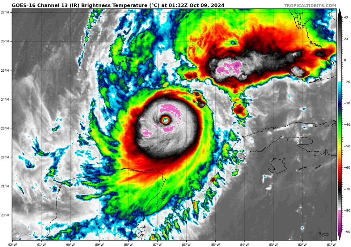
It seems like we have a bit of a contrast between IR and Recon. If we observed Hurricane Milton only through IR, I think only a few would consider the hypothesis that this beast is actually weakening. I'm glad that we have recon
0 likes
Sorry for the bad English sometimes...!
For reliable and detailed information for any meteorological phenomenon, please consult the National Hurricane Center, Joint Typhoon Warning Center , or your local Meteo Center.
--------
ECCE OMNIA NOVA FACIAM (Ap 21,5).
For reliable and detailed information for any meteorological phenomenon, please consult the National Hurricane Center, Joint Typhoon Warning Center , or your local Meteo Center.
--------
ECCE OMNIA NOVA FACIAM (Ap 21,5).

Re: ATL: MILTON - Hurricane - Discussion: 165 mph / 902 mbs
Ok so.do I understand this right? The Loop Current can strengthen Milton and also might steer him more south because of the LC's position right now?
0 likes
Alicia, Rita, Ike, Harvey and Beryl...moved to Splendora lol
-
CrazyC83
- Professional-Met

- Posts: 34311
- Joined: Tue Mar 07, 2006 11:57 pm
- Location: Deep South, for the first time!
Re: ATL: MILTON - Hurricane - Discussion: 165 mph / 902 mbs
What is the shear vector going to be in relation to the storm tomorrow? Could it actually not weaken much (if at all) if it is aligned with the movement?
4 likes
-
Hypercane_Kyle

- Category 5
- Posts: 3465
- Joined: Sat Mar 07, 2015 7:58 pm
- Location: Cape Canaveral, FL
Re: ATL: MILTON - Hurricane - Discussion: 165 mph / 902 mbs
Per the GFS, Milton won't run into the wall of shear until maybe 18z tomorrow. If it can finish another EWRC and do what it did today before a wall of shear, it may have a third run at a maximum intensity as it goes over the loop current.
7 likes
My posts are my own personal opinion, defer to the National Hurricane Center (NHC) and other NOAA products for decision making during hurricane season.
-
FLLurker32
- Tropical Storm

- Posts: 245
- Joined: Mon Aug 29, 2016 10:31 am
Re: ATL: MILTON - Hurricane - Discussion: 165 mph / 902 mbs
I had to go back and look for my own sanity check.
NHC cone for Helene 24 hours prior to landfall did not even include the county where landfall ultimately occurred. The guidance models were in FAR better agreement then than they are now - and had been for a couple days - and were all wrong.
Milton has been even less predictable. Lest anyone get too comfortable of what they think they know..
6 likes
Heather
-
johngaltfla

- Category 5
- Posts: 2073
- Joined: Sun Jul 10, 2005 9:17 pm
- Location: Sarasota County, FL
- Contact:
Re: ATL: MILTON - Hurricane - Discussion: 165 mph / 902 mbs
CrazyC83 wrote:What is the shear vector going to be in relation to the storm tomorrow? Could it actually not weaken much (if at all) if it is aligned with the movement?
You're killing the Hurricane Party buzz CrazyC.
But in reality, yeah, that wouldn't shock me. The Icon model has been pretty solid and think a 4 hitting hard wouldn't shock any long time observer.
1 likes
-
jasons2k

- Storm2k Executive

- Posts: 8290
- Age: 52
- Joined: Wed Jul 06, 2005 12:32 pm
- Location: The Woodlands, TX
ATL: MILTON - Hurricane - Discussion: 165 mph / 902 mbs
FLLurker32 wrote:I had to go back and look for my own sanity check.
NHC cone for Helene 24 hours prior to landfall did not even include the county where landfall ultimately occurred. The guidance models were in FAR better agreement then than they are now - and had been for a couple days - and were all wrong.
Milton has been even less predictable. Lest anyone get too comfortable of what they think they know..
This is the sobering reality. (Edited: the 24-hr point was just inside the cone)
And there is still a lot of disagreement amongst pro-mets as to where this is going. My wife tried to pin me down earlier & asked me where I thought and I said “right over the Skyway Bridge is as good a guess as any right now”
4 likes
Who is online
Users browsing this forum: No registered users and 21 guests