ATL: MILTON - Models
Moderator: S2k Moderators

Re: ATL: MILTON - Models
It seems the deciding factor for Tampa will be weither Milton goes from a northeast movement to an east northeast movement around three in the morning.
0 likes
-
FLLurker32
- Tropical Storm

- Posts: 245
- Joined: Mon Aug 29, 2016 10:31 am
Re: ATL: MILTON - Models
BobHarlem wrote:Love it or hate it, here's the GRAF
https://twitter.com/jnelsonWJCL/status/1843841847065530794
Woah. Not only Tampa but the way it’s continuing a hard NE across the state would cause problems through ALL central FL metro areas, St. Augustine and Jacksonville. Ugly run.
0 likes
Heather
-
Tekken_Guy
- Tropical Storm
- Posts: 150
- Joined: Fri Sep 01, 2017 8:08 pm
Re: ATL: MILTON - Models
Fancy1002 wrote:It seems the deciding factor for Tampa will be weither Milton goes from a northeast movement to an east northeast movement around three in the morning.
Which one’s which?
0 likes
Re: ATL: MILTON - Models
Tekken_Guy wrote:Fancy1002 wrote:It seems the deciding factor for Tampa will be weither Milton goes from a northeast movement to an east northeast movement around three in the morning.
Which one’s which?
North east sends it into or just above the bay, while east northeast sends it just below the bay.
0 likes


Re: ATL: MILTON - Models
BobHarlem wrote:0z Canadian also sticks to it's 12z point, between Sarasota/Bradenton, out Cape Canaveral
https://i.imgur.com/GoZNUIm.gif
If the globals wind up being correct, I'm really wondering about what went wrong the earlies.
It wouldn't be the first time, the were biased with Francine, and they were biased with Helene.
1 likes
-
Keldeo1997
- Category 2

- Posts: 688
- Joined: Fri Oct 11, 2019 11:35 pm


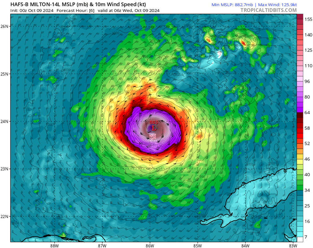
Re: ATL: MILTON - Models
HAFS-B wants a mid-range Cat 4 to tie Wilma's pressure 
2 likes
TC naming lists: retirements and intensity
Most aggressive Advisory #1's in North Atlantic (cr. kevin for starting the list)
Most aggressive Advisory #1's in North Atlantic (cr. kevin for starting the list)

Re: ATL: MILTON - Models
Like I said, everything seems to depend on whether it makes that directional shift in between midnight and 3 AM. I’ll definitely be staying up to see what happens.
0 likes
-
FLLurker32
- Tropical Storm
- Posts: 245
- Joined: Mon Aug 29, 2016 10:31 am
Re: ATL: MILTON - Models
Same track it had at 18z. Looks like it keeps it more ENE on approach vs. Any NE heading.
0 likes
Heather
Re: ATL: MILTON - Models
Tampa Bay gets slammed with the northern quadrant....no bueno
So far all models are converging between Sarasota and Tampa Bay and stronger
1 likes

Re: ATL: MILTON - Models
Both of the HAFS seem to have shifted slightly south, while the HMON is still heading directly into the bay. HWRF is still running, but my bet is that it will stick to its slight north path.
1 likes
Re: ATL: MILTON - Models
Fancy1002 wrote:Both of the HAFS seem to have shifted slightly south, while the HMON is still heading directly into the bay. HWRF is still running, but my bet is that it will stick to its slight north path.
HWRF has eye right over Downtown Tampa
1 likes
-
FLLurker32
- Tropical Storm
- Posts: 245
- Joined: Mon Aug 29, 2016 10:31 am
Re: ATL: MILTON - Models
Fancy1002 wrote:Both of the HAFS seem to have shifted slightly south, while the HMON is still heading directly into the bay. HWRF is still running, but my bet is that it will stick to its slight north path.
You may have a version more hi res than what I’m looking at but I don’t see any notable change at all in landfall or exit points on either HAFS model. HMON is largely the same as 18z and very similar to 0z GFS. HWRF looks to be around the same as last run, maybe a few miles south from 18z.
1 likes
Heather
Re: ATL: MILTON - Models
Euro shifts north bit and now has landfall now over Tampa Bay or right at the southern tip. Previous run had it closer to Longboat Key/Sarasota
To recap...the 00z runs have not been good for Tampa in both landfall and strength
ICON: Tampa Bay
GFS: Tampa Bay
Canadian: Sarasota/Bradenton
HWRF: St. Petersburg
HMON: Tampa Bay
HAFS: Tampa Bay
Euro: Tampa Bay
To recap...the 00z runs have not been good for Tampa in both landfall and strength
ICON: Tampa Bay
GFS: Tampa Bay
Canadian: Sarasota/Bradenton
HWRF: St. Petersburg
HMON: Tampa Bay
HAFS: Tampa Bay
Euro: Tampa Bay
Last edited by caneseddy on Wed Oct 09, 2024 12:37 am, edited 3 times in total.
6 likes
Re: ATL: MILTON - Models
FLLurker32 wrote:Fancy1002 wrote:Both of the HAFS seem to have shifted slightly south, while the HMON is still heading directly into the bay. HWRF is still running, but my bet is that it will stick to its slight north path.
You may have a version more hi res than what I’m looking at but I don’t see any notable change at all in landfall or exit points on either HAFS model. HMON is largely the same as 18z and very similar to 0z GFS. HWRF looks to be around the same as last run, maybe a few miles south from 18z.
Look on tropical tidbits
1 likes
Re: ATL: MILTON - Models
FLLurker32 wrote:Fancy1002 wrote:Both of the HAFS seem to have shifted slightly south, while the HMON is still heading directly into the bay. HWRF is still running, but my bet is that it will stick to its slight north path.
You may have a version more hi res than what I’m looking at but I don’t see any notable change at all in landfall or exit points on either HAFS model. HMON is largely the same as 18z and very similar to 0z GFS. HWRF looks to be around the same as last run, maybe a few miles south from 18z.
It’s a very slight shift south, likely due to a east north east approach as opposed to a northeast approach
0 likes
Who is online
Users browsing this forum: No registered users and 13 guests