weeniepatrol wrote:https://i.imgur.com/iC2ACAl.png
Probably around 95 kt in reality, my posts are opinion only, etc.
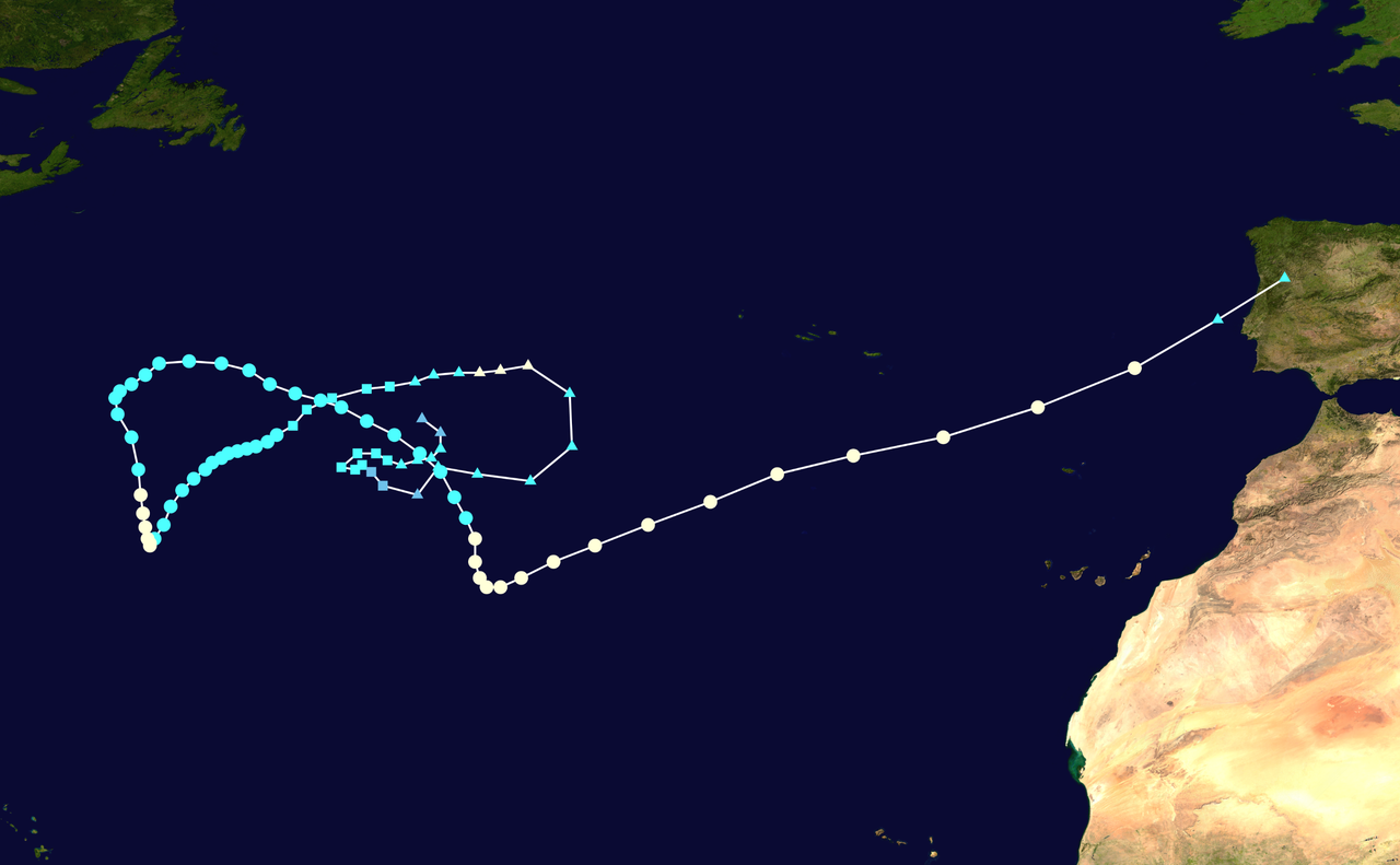
Leslie looks like a pretty formidable cyclone....I haven't paid much attention to it.....will this become stronger?...
Moderator: S2k Moderators
weeniepatrol wrote:https://i.imgur.com/iC2ACAl.png
Probably around 95 kt in reality, my posts are opinion only, etc.


xtyphooncyclonex wrote:Looking like Lingering Leslie won't let her time up just yet...


| First peak 10-06 21z: | Most recent pass 10-09 21z: |
 |  |
Platform: RCM-3 Acquisition Date: 2024-10-06 20:35:21 UTC Storm Name: AL132024 / LESLIE Storm ID: AL13 Storm Center Longitude: -38.723 Storm Center Latitude: 14.188 Incidence Angle (Degrees): 21.348 Quadrant 1 NE VMax (kts): 106.01 Quadrant 2 SE VMax (kts): 79.80 Quadrant 3 SW VMax (kts): 95.53 Quadrant 4 NW VMax (kts): 104.07 RMax (nmi): 7.00 - 9.00 |
Platform: RCM-2 Acquisition Date: 2024-10-09 21:33:37 UTC Storm Name: AL132024 / LESLIE Storm ID: AL13 Storm Center Longitude: -49.032 Storm Center Latitude: 22.078 Incidence Angle (Degrees): 56.170 Quadrant 1 NE VMax (kts): 93.08 Quadrant 2 SE VMax (kts): 84.88 Quadrant 3 SW VMax (kts): 82.06 Quadrant 4 NW VMax (kts): 91.58 RMax (nmi): 7.00 - 8.00 |


Travorum wrote:SAR winds aren't quite up to where they were at the first peak but given Leslie's rapidly improving appearance I expect they will catch up in short time.
First peak 10-06 21z: Most recent pass 10-09 21z: https://i.imgur.com/tERW6al.png https://i.imgur.com/ic7bAYk.png
Acquisition Date: 2024-10-06 20:35:21 UTC
Storm Name: AL132024 / LESLIE
Storm ID: AL13
Storm Center Longitude: -38.723
Storm Center Latitude: 14.188
Incidence Angle (Degrees): 21.348
Quadrant 1 NE VMax (kts): 106.01
Quadrant 2 SE VMax (kts): 79.80
Quadrant 3 SW VMax (kts): 95.53
Quadrant 4 NW VMax (kts): 104.07
RMax (nmi): 7.00 - 9.00
Acquisition Date: 2024-10-09 21:33:37 UTC
Storm Name: AL132024 / LESLIE
Storm ID: AL13
Storm Center Longitude: -49.032
Storm Center Latitude: 22.078
Incidence Angle (Degrees): 56.170
Quadrant 1 NE VMax (kts): 93.08
Quadrant 2 SE VMax (kts): 84.88
Quadrant 3 SW VMax (kts): 82.06
Quadrant 4 NW VMax (kts): 91.58
RMax (nmi): 7.00 - 8.00
aspen wrote:Travorum wrote:SAR winds aren't quite up to where they were at the first peak but given Leslie's rapidly improving appearance I expect they will catch up in short time.
First peak 10-06 21z: Most recent pass 10-09 21z: https://i.imgur.com/tERW6al.png https://i.imgur.com/ic7bAYk.png
Acquisition Date: 2024-10-06 20:35:21 UTC
Storm Name: AL132024 / LESLIE
Storm ID: AL13
Storm Center Longitude: -38.723
Storm Center Latitude: 14.188
Incidence Angle (Degrees): 21.348
Quadrant 1 NE VMax (kts): 106.01
Quadrant 2 SE VMax (kts): 79.80
Quadrant 3 SW VMax (kts): 95.53
Quadrant 4 NW VMax (kts): 104.07
RMax (nmi): 7.00 - 9.00
Acquisition Date: 2024-10-09 21:33:37 UTC
Storm Name: AL132024 / LESLIE
Storm ID: AL13
Storm Center Longitude: -49.032
Storm Center Latitude: 22.078
Incidence Angle (Degrees): 56.170
Quadrant 1 NE VMax (kts): 93.08
Quadrant 2 SE VMax (kts): 84.88
Quadrant 3 SW VMax (kts): 82.06
Quadrant 4 NW VMax (kts): 91.58
RMax (nmi): 7.00 - 8.00
Wow 105 kt from the first peak. So I guess it was significantly under-estimated; I thought 80 kt was reasonable since Leslie’s best structure was so brief.
Teban54 wrote:aspen wrote:Travorum wrote:SAR winds aren't quite up to where they were at the first peak but given Leslie's rapidly improving appearance I expect they will catch up in short time.
First peak 10-06 21z: Most recent pass 10-09 21z: https://i.imgur.com/tERW6al.png https://i.imgur.com/ic7bAYk.png
Acquisition Date: 2024-10-06 20:35:21 UTC
Storm Name: AL132024 / LESLIE
Storm ID: AL13
Storm Center Longitude: -38.723
Storm Center Latitude: 14.188
Incidence Angle (Degrees): 21.348
Quadrant 1 NE VMax (kts): 106.01
Quadrant 2 SE VMax (kts): 79.80
Quadrant 3 SW VMax (kts): 95.53
Quadrant 4 NW VMax (kts): 104.07
RMax (nmi): 7.00 - 9.00
Acquisition Date: 2024-10-09 21:33:37 UTC
Storm Name: AL132024 / LESLIE
Storm ID: AL13
Storm Center Longitude: -49.032
Storm Center Latitude: 22.078
Incidence Angle (Degrees): 56.170
Quadrant 1 NE VMax (kts): 93.08
Quadrant 2 SE VMax (kts): 84.88
Quadrant 3 SW VMax (kts): 82.06
Quadrant 4 NW VMax (kts): 91.58
RMax (nmi): 7.00 - 8.00
Wow 105 kt from the first peak. So I guess it was significantly under-estimated; I thought 80 kt was reasonable since Leslie’s best structure was so brief.
Keep in mind, SAR was showing Jose as a hurricane last year and it wasn't upgrade in TCR. I believe there were other such instances in the last two years, too. I don't think NHC treats it as a reliable tool yet, which means I also don't know how reliable it is.
aspen wrote:Teban54 wrote:aspen wrote:Wow 105 kt from the first peak. So I guess it was significantly under-estimated; I thought 80 kt was reasonable since Leslie’s best structure was so brief.
Keep in mind, SAR was showing Jose as a hurricane last year and it wasn't upgrade in TCR. I believe there were other such instances in the last two years, too. I don't think NHC treats it as a reliable tool yet, which means I also don't know how reliable it is.
Do we have any instances of storms with simultaneous recon and SAR data to judge its accuracy?
Also I thought SAR was used by the NHC at least once before but I forget the context. Maybe I’m mistaken.
cycloneye wrote:https://i.imgur.com/HdNbFyh.gif


Users browsing this forum: No registered users and 28 guests


