
ATL: OSCAR - Models
Moderator: S2k Moderators
-
cycloneye

- Admin

- Posts: 149695
- Age: 69
- Joined: Thu Oct 10, 2002 10:54 am
- Location: San Juan, Puerto Rico
Re: ATL: INVEST 94L - Models
Yikes Euro.
2 likes
Visit the Caribbean-Central America Weather Thread where you can find at first post web cams,radars
and observations from Caribbean basin members Click Here
and observations from Caribbean basin members Click Here
-
jlauderdal
- S2K Supporter

- Posts: 7240
- Joined: Wed May 19, 2004 5:46 am
- Location: NE Fort Lauderdale
- Contact:
Re: ATL: INVEST 94L - Models
Roh roh, a long tracker in late oct.cycloneye wrote:Yikes Euro.
0 likes
-
cycloneye
- Admin
- Posts: 149695
- Age: 69
- Joined: Thu Oct 10, 2002 10:54 am
- Location: San Juan, Puerto Rico
Re: ATL: INVEST 94L - Models
And it ends here.

3 likes
Visit the Caribbean-Central America Weather Thread where you can find at first post web cams,radars
and observations from Caribbean basin members Click Here
and observations from Caribbean basin members Click Here

Re: ATL: INVEST 94L - Models
SFLcane wrote:lol...ok.
https://i.postimg.cc/GpGW59n4/ggggg.png
https://i.postimg.cc/pT1JQYcz/bbbb.png
This is from 94L, believe it or not.
1 likes
Kendall -> SLO -> PBC
Memorable Storms: Katrina (for its Florida landfall...) Wilma Matthew Irma
Memorable Storms: Katrina (for its Florida landfall...) Wilma Matthew Irma
-
TomballEd
- Category 5

- Posts: 1318
- Age: 62
- Joined: Wed Aug 16, 2023 4:52 pm
- Location: Spring/Klein area, not Tomball
Re: ATL: INVEST 94L - Models
SFLcane wrote:lol...ok.
https://i.postimg.cc/GpGW59n4/ggggg.png
https://i.postimg.cc/pT1JQYcz/bbbb.png
That is 94L. Whether it gets dropped as an invest and gets a new number, who knows.
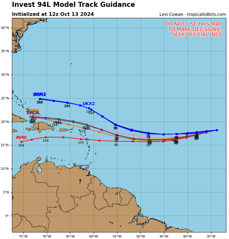
About 20% of the Euro ensembles see this system the GEFS are enthusiastic about next week. All but one go into Central America, a few survive into the BoC.
That any ECENS see the GFS system isn't a good sign. The bad thing about Mitch, it stalled over very high OHC in the Caribbean. If this system does form and does stall for a while, it could be a significant storm. New GEFS has a few stronger members that get pulled into the Gulf (10% of members see another Florida storm). Not sleeping on this but I think 94L has a better chance of development, just beyond the 7 day range NHC forecasts.
4 likes
-
gatorcane

- S2K Supporter
- Posts: 23708
- Age: 48
- Joined: Sun Mar 13, 2005 3:54 pm
- Location: Boca Raton, FL
Re: ATL: INVEST 94L - Models
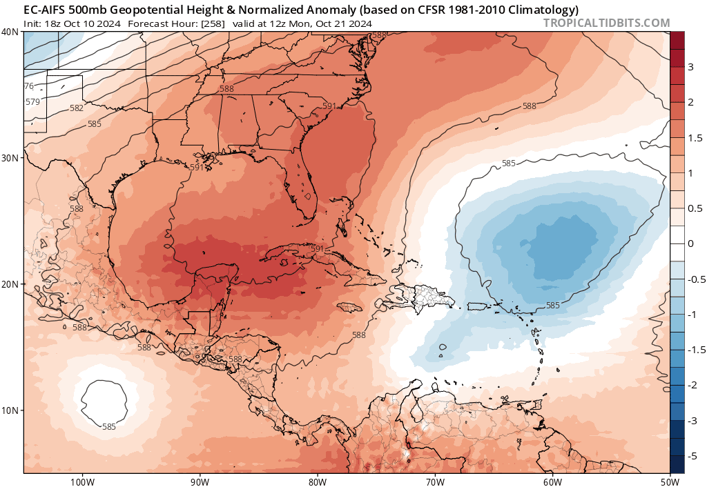
Question is where would it go from there? I would think there would be some weakness to the north that would cause it to get pulled north if it makes it that far north in the NW Caribbean. Looking at the EC-AIFS which has picked up on this system making it into the NW Caribbean also, it is trending with more of a weakness to the north over the Southern US, other models show a cut-off low, last 5 runs below. This feature could cause it to turn north so something to keep an eye on:
GFS long-range (228-300hr):

0 likes
Re: ATL: INVEST 94L - Models
gatorcane wrote:
Question is where would it go from there? I would think there would be some weakness to the north that would cause it to get pulled north if it makes it that far north in the NW Caribbean. Looking at the EC-AIFS which has picked up on this system making it into the NW Caribbean also, it is trending with more of a weakness to the north over the Southern US, other models show a cut-off low, last 5 runs below. This feature could cause it to turn north so something to keep an eye on:
https://i.postimg.cc/yYY98kW1/ec-aifs-z500a-Norm-watl-fh228-trend.gif
GFS long-range (228-300hr):
https://i.postimg.cc/x8tcr3Sw/gfs-z500a-Norm-watl-fh228-300.gif
I agree with you....the way this season has gone thus far...
its entirely possible....have to watch this...
0 likes

Re: ATL: INVEST 94L - Models
Euro ENS 

6 likes
The following post is NOT an official forecast and should not be used as such. It is just the opinion of the poster and may or may not be backed by sound meteorological data. It is NOT endorsed by any professional institution including storm2k.org For Official Information please refer to the NHC and NWS products.

Re: ATL: INVEST 94L - Models
With fairly strong ridging to its north.
Hopefully that will be a Tuesday's gone that puts an end to development from the wave train coming off Africa for the season.
0 likes
Re: ATL: INVEST 94L - Models
zzzh wrote:18Z EPS nearly dropped all development.
Next 24 hrs yes but then starts to come back. 12z also lost it for a few hours. Only out to 144hr in 18z or else I would expect much more active later in the Caribbean.

4 likes
The following post is NOT an official forecast and should not be used as such. It is just the opinion of the poster and may or may not be backed by sound meteorological data. It is NOT endorsed by any professional institution including storm2k.org For Official Information please refer to the NHC and NWS products.
Re: ATL: INVEST 94L - Models
blp wrote:zzzh wrote:18Z EPS nearly dropped all development.
Next 24 hrs yes but then starts to come back. 12z also lost it for a few hours. Only out to 144hr in 18z or else I would expect much more active later in the Caribbean.
https://i.ibb.co/6Zc47J2/ecens-2024-10-12-18-Z-144-50-258-0-350-MSLP-Surface-tracks-lows.png

I was looking at this. It looks like there is something wrong with the weathermodel EPS plot lol
2 likes
Re: ATL: INVEST 94L - Models
GFS no longer drops this. We got all the major models on board this survives and heads into the Caribbean.
0 likes
The following post is NOT an official forecast and should not be used as such. It is just the opinion of the poster and may or may not be backed by sound meteorological data. It is NOT endorsed by any professional institution including storm2k.org For Official Information please refer to the NHC and NWS products.

Re: ATL: INVEST 94L - Models
blp wrote:GFS no longer drops this. We got all the major models on board this survives and heads into the Caribbean.
GFS really wants a repeat of the Eta-Iota one-two punch:

0 likes
TC naming lists: retirements and intensity
Most aggressive Advisory #1's in North Atlantic (cr. kevin for starting the list)
Most aggressive Advisory #1's in North Atlantic (cr. kevin for starting the list)
-
cycloneye
- Admin
- Posts: 149695
- Age: 69
- Joined: Thu Oct 10, 2002 10:54 am
- Location: San Juan, Puerto Rico
Re: ATL: INVEST 94L - Models
00z Euro.

0 likes
Visit the Caribbean-Central America Weather Thread where you can find at first post web cams,radars
and observations from Caribbean basin members Click Here
and observations from Caribbean basin members Click Here

Re: ATL: INVEST 94L - Models
Interesting 12z icon run with 94L Not sure I recall a system that moved SW near/over Hispaniola to get to Jamaica.

5 likes
-
jlauderdal
- S2K Supporter
- Posts: 7240
- Joined: Wed May 19, 2004 5:46 am
- Location: NE Fort Lauderdale
- Contact:
Re: ATL: INVEST 94L - Models
I sent the SEFL deflector shield to cycloneye.BobHarlem wrote:Interesting 12z icon run with 94L Not sure I recall a system that moved SW near/over Hispaniola to get to Jamaica.
3 likes
Re: ATL: INVEST 94L - Models
That is pretty insane to go all that way....in the middle of OCTOBER!!!
1 likes
Cleo - 1964, Betsy - 1965, David - 1979, Andrew - 1992, Charlie (Francis, Ivan, Jeanne) - 2004, Irma - 2017, Ian - 2022, Milton - 2024
Who is online
Users browsing this forum: No registered users and 54 guests