
96W INVEST 241019 0000 13.8N 138.9E WPAC 15 0
WPAC: TRAMI - Post-Tropical
Moderator: S2k Moderators
WPAC: TRAMI - Post-Tropical
Last edited by Hayabusa on Wed Oct 23, 2024 2:30 am, edited 5 times in total.
0 likes
ヤンデレ女が寝取られるているのを見たい!!!
ECMWF ensemble NWPAC plots: https://ecmwfensnwpac.imgbb.com/
Multimodel NWPAC plots: https://multimodelnwpac.imgbb.com/
GFS Ensemble NWPAC plots (16 & 35 day forecast): https://gefsnwpac.imgbb.com/
Plots updated automatically
ECMWF ensemble NWPAC plots: https://ecmwfensnwpac.imgbb.com/
Multimodel NWPAC plots: https://multimodelnwpac.imgbb.com/
GFS Ensemble NWPAC plots (16 & 35 day forecast): https://gefsnwpac.imgbb.com/
Plots updated automatically
Re: WPAC: INVEST 96W
JMA's LPA location the same as this invest.
WWJP27 RJTD 190000
WARNING AND SUMMARY 190000.
WARNING VALID 200000.
WARNING IS UPDATED EVERY 6 HOURS.
LOW PRESSURE AREA 1008 HPA NEAR 14N 139E WEST SLOWLY.
WARNING AND SUMMARY 190000.
WARNING VALID 200000.
WARNING IS UPDATED EVERY 6 HOURS.
LOW PRESSURE AREA 1008 HPA NEAR 14N 139E WEST SLOWLY.
0 likes
ヤンデレ女が寝取られるているのを見たい!!!
ECMWF ensemble NWPAC plots: https://ecmwfensnwpac.imgbb.com/
Multimodel NWPAC plots: https://multimodelnwpac.imgbb.com/
GFS Ensemble NWPAC plots (16 & 35 day forecast): https://gefsnwpac.imgbb.com/
Plots updated automatically
ECMWF ensemble NWPAC plots: https://ecmwfensnwpac.imgbb.com/
Multimodel NWPAC plots: https://multimodelnwpac.imgbb.com/
GFS Ensemble NWPAC plots (16 & 35 day forecast): https://gefsnwpac.imgbb.com/
Plots updated automatically
Re: WPAC: INVEST 96W
Now medium
ABPW10 PGTW 190330
MSGID/GENADMIN/JOINT TYPHOON WRNCEN PEARL HARBOR HI//
SUBJ/SIGNIFICANT TROPICAL WEATHER ADVISORY FOR THE WESTERN AND SOUTH
PACIFIC OCEANS REISSUED/190330Z-190600ZOCT2024//
RMKS/
1. WESTERN NORTH PACIFIC AREA (180 TO MALAY PENINSULA):
A. TROPICAL CYCLONE SUMMARY: NONE.
B. TROPICAL DISTURBANCE SUMMARY:
(1) THE AREA OF CONVECTION (INVEST 94W) PREVIOUSLY LOCATED
NEAR 15.6N 136.9E HAS DISSIPATED AND IS NO LONGER SUSPECT FOR THE
DEVELOPMENT OF A SIGNIFICANT TROPICAL CYCLONE IN THE NEXT 24 HOURS.
(2) AN AREA OF CONVECTION (INVEST 95W) HAS PERSISTED NEAR 12.5N
144.5E, APPROXIMATELY 54 NM SOUTH OF GUAM. ANIMATED MULTISPECTRAL
SATELLITE IMAGERY DEPICTS A BROAD AREA OF FLARING CONVECTION WITH A
WEAKLY DEFINED LOW LEVEL CIRCULATION CENTER (LLCC). ENVIRONMENTAL
ANALYSIS REVEALS THAT INVEST 95W IS IN A FAVORABLE ENVIRONMENT FOR
FURTHER DEVELOPMENT WITH, GOOD RADIAL OUTFLOW ALOFT, VERY WARM SEA
SURFACE TEMPERATURES (30-31C), OFFSET BY LOW VERTICAL WIND SHEAR (10-
15KTS). GLOBAL MODELS ARE IN GOOD AGREEMENT THAT INVEST 95W WILL
GENERALLY TRACK IN A SLOW AND ERRATIC DIRECTION NORTHEASTWARD OVER
THE NEXT 48 HOURS. MAXIMUM SUSTAINED SURFACE WINDS ARE ESTIMATED AT
13 TO 18 KNOTS. MINIMUM SEA LEVEL PRESSURE IS ESTIMATED TO BE NEAR
1009 MB. THE POTENTIAL FOR THE DEVELOPMENT OF A SIGNIFICANT TROPICAL
CYCLONE WITHIN THE NEXT 24 HOURS IS LOW.
(3) AN AREA OF CONVECTION (INVEST 96W) HAS PERSISTED NEAR 13.8N
138.9E, APPROXIMATELY 342 NM WEST OF GUAM. ANIMATED MULTISPECTRAL
SATELLITE IMAGERY SHOWS A VERY WEAK VORTEX WITH LIGHT WINDS WRAPPING
AROUND THE CIRCULATION. THERE IS A DISCERNABLE VORTEX AND DEEP
MOISTURE FIELDS TO THE SOUTHWEST ARE BEGINNING TO FOCUS AROUND THE
VORTEX. ENVIRONMENTAL ANALYSIS REVEALS THAT THE AREA IS RICH, AND
NEARLY IDEAL FOR DEVELOPMENT BUT NARROW, WITH GOOD RADIAL OUTFLOW
ALOFT, WARM SEA SURFACE TEMPERATURE (30C), OFFSET BY MODERATE
VERTICAL WIND SHEAR (15-20 KTS). THE FAVORABLE AXIS OF DEVELOPMENT
EXTENDING NEARLY DUE EAST THROUGH WEST BETWEEN THE 11TH AND 15
LATITUDES. MODEL GUIDANCE OVER THE PAST 48 HOURS HAS BEEN ALIGNING
AND SHOWING MORE CONVICTION THAT A SIGNIFICANT TROPICAL CYCLONE WILL
DEVELOP IN THE AREA WITHIN THE NEXT 24-72 HOURS. MAXIMUM SUSTAINED
SURFACE WINDS ARE ESTIMATED AT 13 TO 18 KNOTS. MINIMUM SEA LEVEL
PRESSURE IS ESTIMATED TO BE NEAR 1009 MB. THE POTENTIAL FOR THE
DEVELOPMENT OF A SIGNIFICANT TROPICAL CYCLONE WITHIN THE NEXT 24
HOURS IS MEDIUM.
0 likes
ヤンデレ女が寝取られるているのを見たい!!!
ECMWF ensemble NWPAC plots: https://ecmwfensnwpac.imgbb.com/
Multimodel NWPAC plots: https://multimodelnwpac.imgbb.com/
GFS Ensemble NWPAC plots (16 & 35 day forecast): https://gefsnwpac.imgbb.com/
Plots updated automatically
ECMWF ensemble NWPAC plots: https://ecmwfensnwpac.imgbb.com/
Multimodel NWPAC plots: https://multimodelnwpac.imgbb.com/
GFS Ensemble NWPAC plots (16 & 35 day forecast): https://gefsnwpac.imgbb.com/
Plots updated automatically
Re: WPAC: INVEST 96W
Looks like this is the invest that the models are tracking (and developing significantly by the GFS and EC-AIFS) towards the Philippines...
0 likes
ヤンデレ女が寝取られるているのを見たい!!!
ECMWF ensemble NWPAC plots: https://ecmwfensnwpac.imgbb.com/
Multimodel NWPAC plots: https://multimodelnwpac.imgbb.com/
GFS Ensemble NWPAC plots (16 & 35 day forecast): https://gefsnwpac.imgbb.com/
Plots updated automatically
ECMWF ensemble NWPAC plots: https://ecmwfensnwpac.imgbb.com/
Multimodel NWPAC plots: https://multimodelnwpac.imgbb.com/
GFS Ensemble NWPAC plots (16 & 35 day forecast): https://gefsnwpac.imgbb.com/
Plots updated automatically
Re: WPAC: INVEST 96W
TCFA

WTPN21 PGTW 191500
MSGID/GENADMIN/JOINT TYPHOON WRNCEN PEARL HARBOR HI//
SUBJ/TROPICAL CYCLONE FORMATION ALERT//
RMKS/
1. FORMATION OF A SIGNIFICANT TROPICAL CYCLONE IS POSSIBLE WITHIN
130 NM EITHER SIDE OF A LINE FROM 14.0N 138.4E TO 15.4N 132.9E
WITHIN THE NEXT 12 TO 24 HOURS. AVAILABLE DATA DOES NOT JUSTIFY
ISSUANCE OF NUMBERED TROPICAL CYCLONE WARNINGS AT THIS TIME.
WINDS IN THE AREA ARE ESTIMATED TO BE 18 TO 23 KNOTS. METSAT
IMAGERY AT 191200Z INDICATES THAT A CIRCULATION CENTER IS LOCATED
NEAR 14.1N 138.1E. THE SYSTEM IS MOVING WEST-NORTHWESTWARD AT 04
KNOTS.
2. REMARKS: THE AREA OF CONVECTION (INVEST 96W) PREVIOUSLY LOCATED NEAR
13.8N 138.9E IS NOW LOCATED NEAR 14.1N 138.1E, APPROXIMATELY 385NM WEST
OF GUAM. ANIMATED ENHANCED INFRARED SATELLITE IMAGERY DEPICTS AN
ELONGATED SYSTEM WITH A CONSOLIDATING LOW-LEVEL CIRCULATION CENTER (LLCC)
BOUNDED BY FORMATIVE CONVECTIVE BANDING WRAPPING AROUND THE NORTHERN AND
SOUTHERN PERIPHERIES. A 191136Z ASCAT METOP-B 25KM SCATTEROMETERY PASS
REVEALS THAT INVEST 96W HAS MODERATE WINDS (15-20KTS) FROM THE NORTHEAST
AND A BAND OF 10-15 KNOT WINDS FROM THE SOUTHWEST WRAP IN TO THE LLCC.
ENVIRONMENTAL ANALYSIS INDICATES THAT INVEST 96W IS IN A FAVORABLE
ENVIRONMENT FOR FURTHER DEVELOPMENT DUE TO VERY WARM (30-31C) SEA SURFACE
TEMPERATURES, LOW (LESS THAN 15 KTS) VERTICAL WIND SHEAR, AND GOOD
POLEWARD AND EQUATORWARD OUTFLOW ALOFT. NUMERICAL MODELS ARE IN GOOD
AGREEMENT THAT INVEST 96W WILL CONTINUE TO TRACK WEST-SOUTHWESTWARD AND
CONSOLIDATE QUICKLY OVER THE NEXT 36-48 HOURS. MAXIMUM SUSTAINED SURFACE
WINDS ARE ESTIMATED AT 18 TO 23 KNOTS. MINIMUM SEA LEVEL PRESSURE IS
ESTIMATED TO BE NEAR 1005 MB. THE POTENTIAL FOR THE DEVELOPMENT OF A
SIGNIFICANT TROPICAL CYCLONE WITHIN THE NEXT 24 HOURS IS HIGH.
3. THIS ALERT WILL BE REISSUED, UPGRADED TO WARNING OR CANCELLED BY
201500Z.//
NNNN
0 likes
ヤンデレ女が寝取られるているのを見たい!!!
ECMWF ensemble NWPAC plots: https://ecmwfensnwpac.imgbb.com/
Multimodel NWPAC plots: https://multimodelnwpac.imgbb.com/
GFS Ensemble NWPAC plots (16 & 35 day forecast): https://gefsnwpac.imgbb.com/
Plots updated automatically
ECMWF ensemble NWPAC plots: https://ecmwfensnwpac.imgbb.com/
Multimodel NWPAC plots: https://multimodelnwpac.imgbb.com/
GFS Ensemble NWPAC plots (16 & 35 day forecast): https://gefsnwpac.imgbb.com/
Plots updated automatically
Re: WPAC: INVEST 96W
06z eps

1 likes
ヤンデレ女が寝取られるているのを見たい!!!
ECMWF ensemble NWPAC plots: https://ecmwfensnwpac.imgbb.com/
Multimodel NWPAC plots: https://multimodelnwpac.imgbb.com/
GFS Ensemble NWPAC plots (16 & 35 day forecast): https://gefsnwpac.imgbb.com/
Plots updated automatically
ECMWF ensemble NWPAC plots: https://ecmwfensnwpac.imgbb.com/
Multimodel NWPAC plots: https://multimodelnwpac.imgbb.com/
GFS Ensemble NWPAC plots (16 & 35 day forecast): https://gefsnwpac.imgbb.com/
Plots updated automatically
-
mrbagyo

- Category 5

- Posts: 3985
- Age: 33
- Joined: Thu Apr 12, 2012 9:18 am
- Location: 14.13N 120.98E
- Contact:
Re: WPAC: INVEST 96W
Hayabusa wrote:TCFA
https://i.imgur.com/winFV9m.gifWTPN21 PGTW 191500
MSGID/GENADMIN/JOINT TYPHOON WRNCEN PEARL HARBOR HI//
SUBJ/TROPICAL CYCLONE FORMATION ALERT//
RMKS/
1. FORMATION OF A SIGNIFICANT TROPICAL CYCLONE IS POSSIBLE WITHIN
130 NM EITHER SIDE OF A LINE FROM 14.0N 138.4E TO 15.4N 132.9E
WITHIN THE NEXT 12 TO 24 HOURS. AVAILABLE DATA DOES NOT JUSTIFY
ISSUANCE OF NUMBERED TROPICAL CYCLONE WARNINGS AT THIS TIME.
WINDS IN THE AREA ARE ESTIMATED TO BE 18 TO 23 KNOTS. METSAT
IMAGERY AT 191200Z INDICATES THAT A CIRCULATION CENTER IS LOCATED
NEAR 14.1N 138.1E. THE SYSTEM IS MOVING WEST-NORTHWESTWARD AT 04
KNOTS.
2. REMARKS: THE AREA OF CONVECTION (INVEST 96W) PREVIOUSLY LOCATED NEAR
13.8N 138.9E IS NOW LOCATED NEAR 14.1N 138.1E, APPROXIMATELY 385NM WEST
OF GUAM. ANIMATED ENHANCED INFRARED SATELLITE IMAGERY DEPICTS AN
ELONGATED SYSTEM WITH A CONSOLIDATING LOW-LEVEL CIRCULATION CENTER (LLCC)
BOUNDED BY FORMATIVE CONVECTIVE BANDING WRAPPING AROUND THE NORTHERN AND
SOUTHERN PERIPHERIES. A 191136Z ASCAT METOP-B 25KM SCATTEROMETERY PASS
REVEALS THAT INVEST 96W HAS MODERATE WINDS (15-20KTS) FROM THE NORTHEAST
AND A BAND OF 10-15 KNOT WINDS FROM THE SOUTHWEST WRAP IN TO THE LLCC.
ENVIRONMENTAL ANALYSIS INDICATES THAT INVEST 96W IS IN A FAVORABLE
ENVIRONMENT FOR FURTHER DEVELOPMENT DUE TO VERY WARM (30-31C) SEA SURFACE
TEMPERATURES, LOW (LESS THAN 15 KTS) VERTICAL WIND SHEAR, AND GOOD
POLEWARD AND EQUATORWARD OUTFLOW ALOFT. NUMERICAL MODELS ARE IN GOOD
AGREEMENT THAT INVEST 96W WILL CONTINUE TO TRACK WEST-SOUTHWESTWARD AND
CONSOLIDATE QUICKLY OVER THE NEXT 36-48 HOURS. MAXIMUM SUSTAINED SURFACE
WINDS ARE ESTIMATED AT 18 TO 23 KNOTS. MINIMUM SEA LEVEL PRESSURE IS
ESTIMATED TO BE NEAR 1005 MB. THE POTENTIAL FOR THE DEVELOPMENT OF A
SIGNIFICANT TROPICAL CYCLONE WITHIN THE NEXT 24 HOURS IS HIGH.
3. THIS ALERT WILL BE REISSUED, UPGRADED TO WARNING OR CANCELLED BY
201500Z.//
NNNN
That's quick
0 likes
The posts in this forum are NOT official forecast and should not be used as such. They are just the opinion of the poster and may or may not be backed by sound meteorological data. They are NOT endorsed by any professional institution or storm2k.org. For official information, please refer to RSMC, NHC and NWS products.
Re: WPAC: Tropical Depression 96W
WWJP27 RJTD 191800
WARNING AND SUMMARY 191800.
WARNING VALID 201800.
WARNING IS UPDATED EVERY 6 HOURS.
TROPICAL DEPRESSION 1004 HPA AT 14N 138E WEST SLOWLY.
WARNING AND SUMMARY 191800.
WARNING VALID 201800.
WARNING IS UPDATED EVERY 6 HOURS.
TROPICAL DEPRESSION 1004 HPA AT 14N 138E WEST SLOWLY.
0 likes
ヤンデレ女が寝取られるているのを見たい!!!
ECMWF ensemble NWPAC plots: https://ecmwfensnwpac.imgbb.com/
Multimodel NWPAC plots: https://multimodelnwpac.imgbb.com/
GFS Ensemble NWPAC plots (16 & 35 day forecast): https://gefsnwpac.imgbb.com/
Plots updated automatically
ECMWF ensemble NWPAC plots: https://ecmwfensnwpac.imgbb.com/
Multimodel NWPAC plots: https://multimodelnwpac.imgbb.com/
GFS Ensemble NWPAC plots (16 & 35 day forecast): https://gefsnwpac.imgbb.com/
Plots updated automatically
Re: WPAC: Tropical Depression 96W
Eps 12z showing sub 900mb, though looks like from a different system...

0 likes
ヤンデレ女が寝取られるているのを見たい!!!
ECMWF ensemble NWPAC plots: https://ecmwfensnwpac.imgbb.com/
Multimodel NWPAC plots: https://multimodelnwpac.imgbb.com/
GFS Ensemble NWPAC plots (16 & 35 day forecast): https://gefsnwpac.imgbb.com/
Plots updated automatically
ECMWF ensemble NWPAC plots: https://ecmwfensnwpac.imgbb.com/
Multimodel NWPAC plots: https://multimodelnwpac.imgbb.com/
GFS Ensemble NWPAC plots (16 & 35 day forecast): https://gefsnwpac.imgbb.com/
Plots updated automatically
-
dexterlabio
- Category 5
- Posts: 3517
- Joined: Sat Oct 24, 2009 11:50 pm
Re: WPAC: Tropical Depression 96W
The only thing getting in the way to attain crazy intensity is its enormous size...unless it manages to pull off a Tip..
0 likes
Personal Forecast Disclaimer:
The posts in this forum are NOT official forecast and should not be used as such. They are just the opinion of the poster and may or may not be backed by sound meteorological data. They are NOT endorsed by any professional institution or storm2k.org. For official information, please refer to the NHC and NWS products.
The posts in this forum are NOT official forecast and should not be used as such. They are just the opinion of the poster and may or may not be backed by sound meteorological data. They are NOT endorsed by any professional institution or storm2k.org. For official information, please refer to the NHC and NWS products.
Re: WPAC: 96W - Tropical Depression
TD a
Issued at 2024/10/20 07:10 UTC
Analysis at 10/20 06 UTC
Grade TD
Scale -
Intensity -
Center position N14°10′ (14.2°)
E136°50′ (136.8°)
Direction and speed of movement W 10 km/h (6 kt)
Central pressure 1002 hPa
Maximum sustained wind speed near center 15 m/s (30 kt)
Maximum wind gust speed 23 m/s (45 kt)
Forecast for 10/20 18 UTC
Grade TD
Intensity -
Center position of probability circle N13°35′ (13.6°)
E134°00′ (134.0°)
Direction and speed of movement W 25 km/h (14 kt)
Central pressure 1002 hPa
Maximum sustained wind speed near center 15 m/s (30 kt)
Maximum wind gust speed 23 m/s (45 kt)
Radius of probability circle 100 km (55 NM)
Forecast for 10/21 06 UTC
Grade TS
Intensity -
Center position of probability circle N13°30′ (13.5°)
E131°25′ (131.4°)
Direction and speed of movement W 25 km/h (13 kt)
Central pressure 998 hPa
Maximum sustained wind speed near center 18 m/s (35 kt)
Maximum wind gust speed 25 m/s (50 kt)
Radius of probability circle 130 km (70 NM)
Forecast for 10/22 06 UTC
Grade TS
Intensity -
Center position of probability circle N14°25′ (14.4°)
E129°00′ (129.0°)
Direction and speed of movement WNW 10 km/h (6 kt)
Central pressure 994 hPa
Maximum sustained wind speed near center 20 m/s (40 kt)
Maximum wind gust speed 30 m/s (60 kt)
Radius of probability circle 200 km (110 NM)
Forecast for 10/23 06 UTC
Grade TS
Intensity -
Center position of probability circle N16°10′ (16.2°)
E126°40′ (126.7°)
Direction and speed of movement NW 15 km/h (7 kt)
Central pressure 990 hPa
Maximum sustained wind speed near center 23 m/s (45 kt)
Maximum wind gust speed 35 m/s (65 kt)
Radius of probability circle 260 km (140 NM)
Forecast for 10/24 06 UTC
Grade STS
Intensity -
Center position of probability circle N17°30′ (17.5°)
E124°30′ (124.5°)
Direction and speed of movement NW 10 km/h (6 kt)
Central pressure 985 hPa
Maximum sustained wind speed near center 25 m/s (50 kt)
Maximum wind gust speed 35 m/s (70 kt)
Radius of probability circle 330 km (180 NM)
Forecast for 10/25 06 UTC
Grade STS
Intensity -
Center position of probability circle N18°30′ (18.5°)
E123°00′ (123.0°)
Direction and speed of movement NW Slow
Central pressure 985 hPa
Maximum sustained wind speed near center 25 m/s (50 kt)
Maximum wind gust speed 35 m/s (70 kt)
Radius of probability circle 440 km (240 NM)
0 likes
ヤンデレ女が寝取られるているのを見たい!!!
ECMWF ensemble NWPAC plots: https://ecmwfensnwpac.imgbb.com/
Multimodel NWPAC plots: https://multimodelnwpac.imgbb.com/
GFS Ensemble NWPAC plots (16 & 35 day forecast): https://gefsnwpac.imgbb.com/
Plots updated automatically
ECMWF ensemble NWPAC plots: https://ecmwfensnwpac.imgbb.com/
Multimodel NWPAC plots: https://multimodelnwpac.imgbb.com/
GFS Ensemble NWPAC plots (16 & 35 day forecast): https://gefsnwpac.imgbb.com/
Plots updated automatically
Re: WPAC: 22W - Tropical Depression
22W TWENTYTWO 241020 1200 14.9N 136.0E WPAC 25 1001
0 likes
ヤンデレ女が寝取られるているのを見たい!!!
ECMWF ensemble NWPAC plots: https://ecmwfensnwpac.imgbb.com/
Multimodel NWPAC plots: https://multimodelnwpac.imgbb.com/
GFS Ensemble NWPAC plots (16 & 35 day forecast): https://gefsnwpac.imgbb.com/
Plots updated automatically
ECMWF ensemble NWPAC plots: https://ecmwfensnwpac.imgbb.com/
Multimodel NWPAC plots: https://multimodelnwpac.imgbb.com/
GFS Ensemble NWPAC plots (16 & 35 day forecast): https://gefsnwpac.imgbb.com/
Plots updated automatically
Re: WPAC: 22W - Tropical Depression
06z eps

0 likes
ヤンデレ女が寝取られるているのを見たい!!!
ECMWF ensemble NWPAC plots: https://ecmwfensnwpac.imgbb.com/
Multimodel NWPAC plots: https://multimodelnwpac.imgbb.com/
GFS Ensemble NWPAC plots (16 & 35 day forecast): https://gefsnwpac.imgbb.com/
Plots updated automatically
ECMWF ensemble NWPAC plots: https://ecmwfensnwpac.imgbb.com/
Multimodel NWPAC plots: https://multimodelnwpac.imgbb.com/
GFS Ensemble NWPAC plots (16 & 35 day forecast): https://gefsnwpac.imgbb.com/
Plots updated automatically
Re: WPAC: 22W - Tropical Depression

1 likes
ヤンデレ女が寝取られるているのを見たい!!!
ECMWF ensemble NWPAC plots: https://ecmwfensnwpac.imgbb.com/
Multimodel NWPAC plots: https://multimodelnwpac.imgbb.com/
GFS Ensemble NWPAC plots (16 & 35 day forecast): https://gefsnwpac.imgbb.com/
Plots updated automatically
ECMWF ensemble NWPAC plots: https://ecmwfensnwpac.imgbb.com/
Multimodel NWPAC plots: https://multimodelnwpac.imgbb.com/
GFS Ensemble NWPAC plots (16 & 35 day forecast): https://gefsnwpac.imgbb.com/
Plots updated automatically
-
WaveBreaking

- Category 2

- Posts: 727
- Joined: Sun Jun 30, 2024 11:33 am
- Location: US
Re: WPAC: 22W - Tropical Depression
This thing is huge even for monsoonal disturbances

3 likes
I am NOT a professional meteorologist, so take all of my posts with a grain of salt. My opinions are mine and mine alone.
-
TyphoonNara

- Category 1

- Posts: 369
- Age: 25
- Joined: Tue Dec 04, 2018 9:41 am
- Location: Hong Kong
Re: WPAC: 22W - Tropical Depression
WaveBreaking wrote:This thing is huge even for monsoonal disturbances
https://i.imgur.com/mhA2RxK.gif
Indeed. It spanned over 55 degrees longitude from east to west. To put in perspective, that's even wider than Tip's outflows. However, Tip still covered a larger area as it was more "vertical".
1 likes
-
mrbagyo
- Category 5
- Posts: 3985
- Age: 33
- Joined: Thu Apr 12, 2012 9:18 am
- Location: 14.13N 120.98E
- Contact:
Re: WPAC: 22W - Tropical Depression
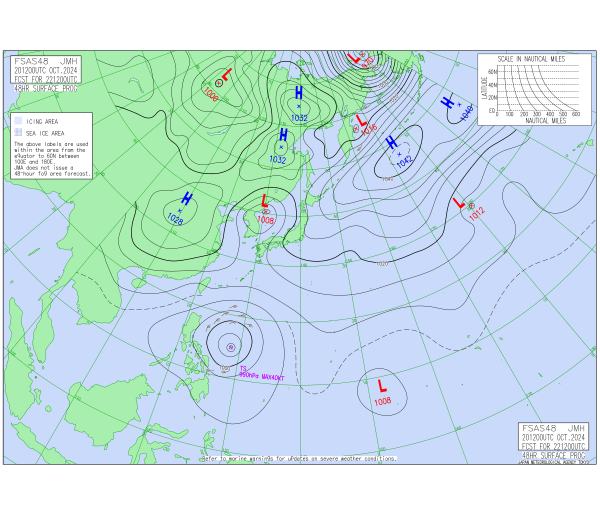
JMA's 48-hr forecast chart shows a comically large system - the area within the outermost closed isobar appears more than twice the size of the entire Philippine Archipelago.
2 likes
The posts in this forum are NOT official forecast and should not be used as such. They are just the opinion of the poster and may or may not be backed by sound meteorological data. They are NOT endorsed by any professional institution or storm2k.org. For official information, please refer to RSMC, NHC and NWS products.
Re: WPAC: TRAMI - Tropical Storm

T2420(Trami)
Issued at 2024/10/21 19:10 UTC
Analysis at 10/21 18 UTC
Grade TS
Scale Large
Intensity -
Center position N13°10′ (13.2°)
E128°10′ (128.2°)
Direction and speed of movement W 30 km/h (17 kt)
Central pressure 994 hPa
Maximum sustained wind speed near center 18 m/s (35 kt)
Maximum wind gust speed 25 m/s (50 kt)
Radius of 30-kt wind area 560 km (300 NM)
Forecast for 10/22 06 UTC
Grade TS
Intensity -
Center position of probability circle N14°40′ (14.7°)
E127°35′ (127.6°)
Direction and speed of movement NNW 15 km/h (8 kt)
Central pressure 990 hPa
Maximum sustained wind speed near center 20 m/s (40 kt)
Maximum wind gust speed 30 m/s (60 kt)
Radius of probability circle 65 km (35 NM)
Forecast for 10/22 18 UTC
Grade TS
Intensity -
Center position of probability circle N15°30′ (15.5°)
E126°20′ (126.3°)
Direction and speed of movement WNW 15 km/h (7 kt)
Central pressure 985 hPa
Maximum sustained wind speed near center 23 m/s (45 kt)
Maximum wind gust speed 35 m/s (65 kt)
Radius of probability circle 95 km (50 NM)
Forecast for 10/23 18 UTC
Grade STS
Intensity -
Center position of probability circle N17°50′ (17.8°)
E122°35′ (122.6°)
Direction and speed of movement WNW 20 km/h (11 kt)
Central pressure 980 hPa
Maximum sustained wind speed near center 25 m/s (50 kt)
Maximum wind gust speed 35 m/s (70 kt)
Radius of probability circle 155 km (85 NM)
Forecast for 10/24 18 UTC
Grade STS
Intensity -
Center position of probability circle N17°40′ (17.7°)
E119°40′ (119.7°)
Direction and speed of movement W 15 km/h (7 kt)
Central pressure 980 hPa
Maximum sustained wind speed near center 25 m/s (50 kt)
Maximum wind gust speed 35 m/s (70 kt)
Radius of probability circle 220 km (120 NM)
Forecast for 10/25 18 UTC
Grade STS
Intensity -
Center position of probability circle N18°20′ (18.3°)
E116°05′ (116.1°)
Direction and speed of movement W 15 km/h (9 kt)
Central pressure 975 hPa
Maximum sustained wind speed near center 30 m/s (55 kt)
Maximum wind gust speed 40 m/s (80 kt)
Radius of probability circle 280 km (150 NM)
Radius of storm warning area 370 km (200 NM)
Forecast for 10/26 18 UTC
Grade STS
Intensity -
Center position of probability circle N18°35′ (18.6°)
E111°55′ (111.9°)
Direction and speed of movement W 20 km/h (10 kt)
Central pressure 980 hPa
Maximum sustained wind speed near center 25 m/s (50 kt)
Maximum wind gust speed 35 m/s (70 kt)
Radius of probability circle 330 km (180 NM)
0 likes
ヤンデレ女が寝取られるているのを見たい!!!
ECMWF ensemble NWPAC plots: https://ecmwfensnwpac.imgbb.com/
Multimodel NWPAC plots: https://multimodelnwpac.imgbb.com/
GFS Ensemble NWPAC plots (16 & 35 day forecast): https://gefsnwpac.imgbb.com/
Plots updated automatically
ECMWF ensemble NWPAC plots: https://ecmwfensnwpac.imgbb.com/
Multimodel NWPAC plots: https://multimodelnwpac.imgbb.com/
GFS Ensemble NWPAC plots (16 & 35 day forecast): https://gefsnwpac.imgbb.com/
Plots updated automatically
-
WaveBreaking
- Category 2
- Posts: 727
- Joined: Sun Jun 30, 2024 11:33 am
- Location: US
Re: WPAC: TRAMI - Tropical Storm
Trami continues to be over-the-top with a ridiculously large LLC and insanely cold cloud tops 

1 likes
I am NOT a professional meteorologist, so take all of my posts with a grain of salt. My opinions are mine and mine alone.

Re: WPAC: TRAMI - Tropical Storm
Kristine floods wash away homes, displace residents in Bicol
https://www.gmanetwork.com/news/topstor ... col/story/
Tropical Storm Kristine/Trami is causing severe flooding from heavy rain.
https://www.gmanetwork.com/news/topstor ... col/story/
Tropical Storm Kristine/Trami is causing severe flooding from heavy rain.
0 likes
Who is online
Users browsing this forum: No registered users and 110 guests