A very dire situation unfolding right now.
https://twitter.com/_GioRobles/status/1848730948025913533
WPAC: TRAMI - Post-Tropical
Moderator: S2k Moderators
-
xtyphooncyclonex

- Category 5

- Posts: 3898
- Age: 24
- Joined: Sat Dec 08, 2012 9:07 am
- Location: Cebu City
- Contact:
Re: WPAC: TRAMI - Tropical Storm
0 likes
REMINDER: My opinions that I, or any other NON Pro-Met in this forum, are unofficial. Please do not take my opinions as an official forecast and warning. I am NOT a meteorologist. Following my forecasts blindly may lead to false alarm, danger and risk if official forecasts from agencies are ignored.
-
CrazyC83
- Professional-Met

- Posts: 34316
- Joined: Tue Mar 07, 2006 11:57 pm
- Location: Deep South, for the first time!
Re: WPAC: TRAMI - Tropical Storm
There was an ASCAT pass about 12 hours ago that had winds of 55 kt at least from it. Not sure where they come up with the 45 kt estimate, since that pass suggested winds of at least 60 kt (conservatively).
0 likes

Re: WPAC: TRAMI - Tropical Storm
Euro wants it to loop back after crossing the south china sea but how far east is the question...
0 likes
ヤンデレ女が寝取られるているのを見たい!!!
ECMWF ensemble NWPAC plots: https://ecmwfensnwpac.imgbb.com/
Multimodel NWPAC plots: https://multimodelnwpac.imgbb.com/
GFS Ensemble NWPAC plots (16 & 35 day forecast): https://gefsnwpac.imgbb.com/
Plots updated automatically
ECMWF ensemble NWPAC plots: https://ecmwfensnwpac.imgbb.com/
Multimodel NWPAC plots: https://multimodelnwpac.imgbb.com/
GFS Ensemble NWPAC plots (16 & 35 day forecast): https://gefsnwpac.imgbb.com/
Plots updated automatically
Re: WPAC: TRAMI - Severe Tropical Storm
T2420(Trami)
Issued at 2024/10/23 06:50 UTC
Analysis at 10/23 06 UTC
Grade STS
Scale Large
Intensity -
Center position N16°05′ (16.1°)
E123°10′ (123.2°)
Direction and speed of movement WNW 20 km/h (12 kt)
Central pressure 985 hPa
Maximum sustained wind speed near center 25 m/s (50 kt)
Maximum wind gust speed 35 m/s (70 kt)
Radius of 30-kt wind area N750 km (400 NM)
S460 km (250 NM)
Forecast for 10/23 18 UTC
Grade STS
Intensity -
Center position of probability circle N17°25′ (17.4°)
E121°35′ (121.6°)
Direction and speed of movement NW 20 km/h (10 kt)
Central pressure 985 hPa
Maximum sustained wind speed near center 25 m/s (50 kt)
Maximum wind gust speed 35 m/s (70 kt)
Radius of probability circle 75 km (40 NM)
Forecast for 10/24 06 UTC
Grade TS
Intensity -
Center position of probability circle N16°25′ (16.4°)
E120°10′ (120.2°)
Direction and speed of movement SW 15 km/h (8 kt)
Central pressure 990 hPa
Maximum sustained wind speed near center 23 m/s (45 kt)
Maximum wind gust speed 35 m/s (65 kt)
Radius of probability circle 105 km (57 NM)
Forecast for 10/25 06 UTC
Grade STS
Intensity -
Center position of probability circle N17°25′ (17.4°)
E117°05′ (117.1°)
Direction and speed of movement WNW 15 km/h (8 kt)
Central pressure 980 hPa
Maximum sustained wind speed near center 30 m/s (55 kt)
Maximum wind gust speed 40 m/s (80 kt)
Radius of probability circle 185 km (100 NM)
Radius of storm warning area 280 km (150 NM)
Forecast for 10/26 06 UTC
Grade STS
Intensity -
Center position of probability circle N17°25′ (17.4°)
E113°05′ (113.1°)
Direction and speed of movement W 20 km/h (10 kt)
Central pressure 975 hPa
Maximum sustained wind speed near center 30 m/s (60 kt)
Maximum wind gust speed 45 m/s (85 kt)
Radius of probability circle 220 km (120 NM)
Radius of storm warning area 310 km (170 NM)
Forecast for 10/27 06 UTC
Grade STS
Intensity -
Center position of probability circle N17°10′ (17.2°)
E110°30′ (110.5°)
Direction and speed of movement W 10 km/h (6 kt)
Central pressure 980 hPa
Maximum sustained wind speed near center 30 m/s (55 kt)
Maximum wind gust speed 40 m/s (80 kt)
Radius of probability circle 280 km (150 NM)
Radius of storm warning area 370 km (200 NM)
Forecast for 10/28 06 UTC
Grade STS
Intensity -
Center position of probability circle N16°30′ (16.5°)
E109°50′ (109.8°)
Direction and speed of movement Almost stationary
Central pressure 985 hPa
Maximum sustained wind speed near center 25 m/s (50 kt)
Maximum wind gust speed 35 m/s (70 kt)
Radius of probability circle 330 km (180 NM)
0 likes
ヤンデレ女が寝取られるているのを見たい!!!
ECMWF ensemble NWPAC plots: https://ecmwfensnwpac.imgbb.com/
Multimodel NWPAC plots: https://multimodelnwpac.imgbb.com/
GFS Ensemble NWPAC plots (16 & 35 day forecast): https://gefsnwpac.imgbb.com/
Plots updated automatically
ECMWF ensemble NWPAC plots: https://ecmwfensnwpac.imgbb.com/
Multimodel NWPAC plots: https://multimodelnwpac.imgbb.com/
GFS Ensemble NWPAC plots (16 & 35 day forecast): https://gefsnwpac.imgbb.com/
Plots updated automatically
Re: WPAC: TRAMI - Severe Tropical Storm
My oldest brother lives in the Luzon area...what can he expect there?....I also have family in Igbarras...near Ililio.....I think they should be good there?.....
0 likes
-
mrbagyo

- Category 5
- Posts: 3997
- Age: 33
- Joined: Thu Apr 12, 2012 9:18 am
- Location: 14.13N 120.98E
- Contact:
Re: WPAC: TRAMI - Severe Tropical Storm
underthwx wrote:My oldest brother lives in the Luzon area...what can he expect there?....I also have family in Igbarras...near Ililio.....I think they should be good there?.....
Depends on where he lives in Luzon.
I think much of the rain will be poured over Central Luzon and the Cordillera if Trami stays badly sheared.
0 likes
The posts in this forum are NOT official forecast and should not be used as such. They are just the opinion of the poster and may or may not be backed by sound meteorological data. They are NOT endorsed by any professional institution or storm2k.org. For official information, please refer to RSMC, NHC and NWS products.
-
dexterlabio
- Category 5
- Posts: 3517
- Joined: Sat Oct 24, 2009 11:50 pm
Re: WPAC: TRAMI - Severe Tropical Storm
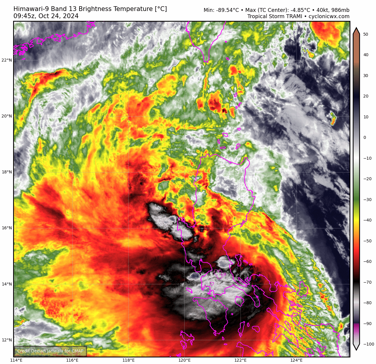
It does look like the center that made landfall in Northern Luzon is fading and a new center has formed east of Batangas/Southern Luzon.
0 likes
Personal Forecast Disclaimer:
The posts in this forum are NOT official forecast and should not be used as such. They are just the opinion of the poster and may or may not be backed by sound meteorological data. They are NOT endorsed by any professional institution or storm2k.org. For official information, please refer to the NHC and NWS products.
The posts in this forum are NOT official forecast and should not be used as such. They are just the opinion of the poster and may or may not be backed by sound meteorological data. They are NOT endorsed by any professional institution or storm2k.org. For official information, please refer to the NHC and NWS products.
-
mrbagyo
- Category 5
- Posts: 3997
- Age: 33
- Joined: Thu Apr 12, 2012 9:18 am
- Location: 14.13N 120.98E
- Contact:
Re: WPAC: TRAMI - Severe Tropical Storm
Trami is truly a prolific producer of deep convection.
1 likes
The posts in this forum are NOT official forecast and should not be used as such. They are just the opinion of the poster and may or may not be backed by sound meteorological data. They are NOT endorsed by any professional institution or storm2k.org. For official information, please refer to RSMC, NHC and NWS products.
Who is online
Users browsing this forum: No registered users and 85 guests