2024 Global Model Runs Discussion (Out thru day 16)
Moderator: S2k Moderators
Forum rules

The posts in this forum are NOT official forecasts and should not be used as such. They are just the opinion of the poster and may or may not be backed by sound meteorological data. They are NOT endorsed by any professional institution or STORM2K. For official information, please refer to products from the National Hurricane Center and National Weather Service.

Re: 2024 Global Model Runs Discussion (Out thru day 16)
Like always.... timing is EVERYTHING and would cause a variety of different outcomes. One such scenario that I find worrisome would be a similar track but one which might occur just north of Cuba, then resulting in a potential extreme S. Florida/Keys (first) landfall, followed by a second Florida W. Coast impact. Hopefully thereafter, any storm track would then continue NE rather than NNE where Georgia and the Carolina have already had their share of flooding.
0 likes
Andy D
(For official information, please refer to the NHC and NWS products.)
(For official information, please refer to the NHC and NWS products.)
-
gatorcane

- S2K Supporter

- Posts: 23708
- Age: 48
- Joined: Sun Mar 13, 2005 3:54 pm
- Location: Boca Raton, FL
Re: 2024 Global Model Runs Discussion (Out thru day 16)
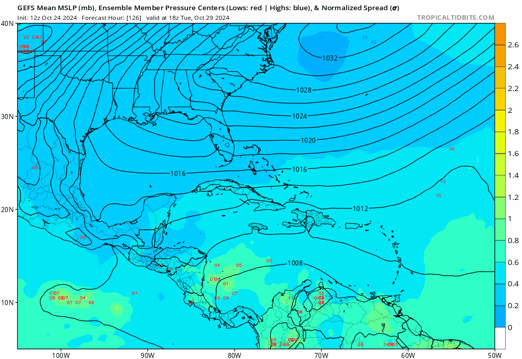
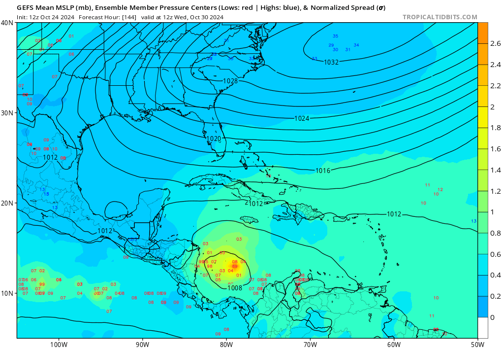
12Z GFS forms a low as early as next Wed and develops it into a significant hurricane with another track into the EGOM. We have seen those “S” tracks before and it’s no bueno (Sandy)

4 likes
-
WaveBreaking

- Category 2

- Posts: 717
- Joined: Sun Jun 30, 2024 11:33 am
- Location: US
Re: 2024 Global Model Runs Discussion (Out thru day 16)
gatorcane wrote:12Z GFS forms a low as early as next Wed and develops it into a significant hurricane with another track into the EGOM. We have seen those “S” tracks before and it’s no bueno (Sandy)
https://i.postimg.cc/XNdNWVjR/gfs-mslp-pcpn-watl-fh138-312.gif
Also an added bonus with that WPAC-style additional development down-shear of the storm that you usually see at the peak of typhoon season.
1 likes
I am NOT a professional meteorologist, so take all of my posts with a grain of salt. My opinions are mine and mine alone.
Re: 2024 Global Model Runs Discussion (Out thru day 16)
I'd have to verify but I think that's 6 straight GFS run Florida hurricane landfalls. For obvious reasons, GFS is having difficulties with the downstream steering pattern and continues to show differing solutions for the strong short wave dropping into the CONUS mid-section. Hopefully the EURO will have a better handle on this as we get closer into it's wheelhouse range.
1 likes
Andy D
(For official information, please refer to the NHC and NWS products.)
(For official information, please refer to the NHC and NWS products.)
Re: 2024 Global Model Runs Discussion (Out thru day 16)
WaveBreaking wrote:gatorcane wrote:12Z GFS forms a low as early as next Wed and develops it into a significant hurricane with another track into the EGOM. We have seen those “S” tracks before and it’s no bueno (Sandy)
https://i.postimg.cc/XNdNWVjR/gfs-mslp-pcpn-watl-fh138-312.gif
Also an added bonus with that WPAC-style additional development down-shear of the storm that you usually see at the peak of typhoon season.
Yeah, that alone seemed really weird to see. Not sure if this would also find itself to continue to deepen while moving west through most of the Caribbean? I question that southward motion given the overall steering flow.
2 likes
Andy D
(For official information, please refer to the NHC and NWS products.)
(For official information, please refer to the NHC and NWS products.)
-
CFLHurricane

- Category 1

- Posts: 349
- Joined: Thu Mar 27, 2014 5:56 pm
- Location: Floriduh
Re: 2024 Global Model Runs Discussion (Out thru day 16)
I was relieved once the first autumnal front moved through the Florida peninsula, but we’ve seen this song and dance from the GFS before and I also expect the NHC to throw up a lemon with genesis consistently predicted by next Wednesday. It appears the high that’s given us this wonderful break isn’t doing it for free and will draw up a witches brew in time for the holidays. 
0 likes
I'm not a meteorologist, but I did stay at a motel 8.
-
gatorcane
- S2K Supporter
- Posts: 23708
- Age: 48
- Joined: Sun Mar 13, 2005 3:54 pm
- Location: Boca Raton, FL
Re: 2024 Global Model Runs Discussion (Out thru day 16)
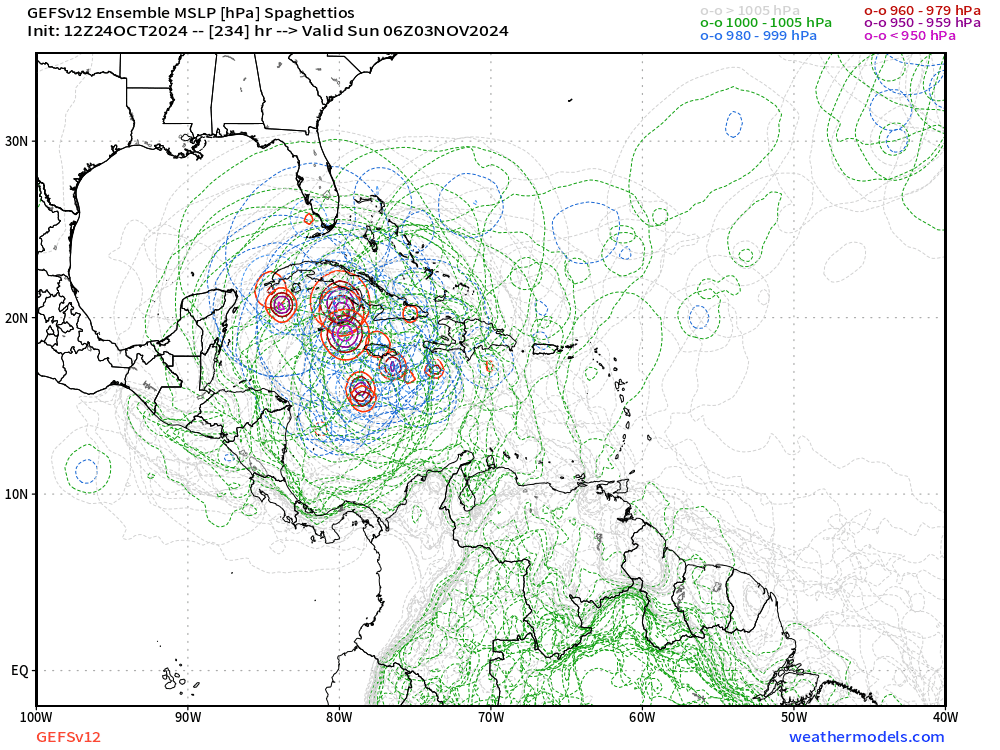
The GFS ensembles are very active yet again
Last edited by gatorcane on Thu Oct 24, 2024 12:27 pm, edited 1 time in total.
1 likes
-
toad strangler

- S2K Supporter
- Posts: 4546
- Joined: Sun Jul 28, 2013 3:09 pm
- Location: Earth
- Contact:
Re: 2024 Global Model Runs Discussion (Out thru day 16)
Well at least broad swaths of the FL coast are pre destroyed. Whatever happens...happens. at this point I'm climo humpin' over cliff jumpin'...
4 likes
-
gatorcane
- S2K Supporter
- Posts: 23708
- Age: 48
- Joined: Sun Mar 13, 2005 3:54 pm
- Location: Boca Raton, FL
Re: 2024 Global Model Runs Discussion (Out thru day 16)
The entire GFS ensemble suite has jumped west in the 12Z and closely follows the GFS op through the long-range of 270 hours.
2 likes
-
WaveBreaking
- Category 2
- Posts: 717
- Joined: Sun Jun 30, 2024 11:33 am
- Location: US
Re: 2024 Global Model Runs Discussion (Out thru day 16)
chaser1 wrote:WaveBreaking wrote:gatorcane wrote:12Z GFS forms a low as early as next Wed and develops it into a significant hurricane with another track into the EGOM. We have seen those “S” tracks before and it’s no bueno (Sandy)
https://i.postimg.cc/XNdNWVjR/gfs-mslp-pcpn-watl-fh138-312.gif
Also an added bonus with that WPAC-style additional development down-shear of the storm that you usually see at the peak of typhoon season.
Yeah, that alone seemed really weird to see. Not sure if this would also find itself to continue to deepen while moving west through most of the Caribbean? I question that southward motion given the overall steering flow.
The GFS has this oddly move due south towards Venezuela and then do a 180 while bombing out past 240h and well into fantasy range. And judging by the wind barbs, the entire monsoon trough connected to the storms also moves south before bouncing north. Definitely a pretty wild GFS run especially for a non-happy hour one.

Last edited by WaveBreaking on Thu Oct 24, 2024 5:13 pm, edited 1 time in total.
3 likes
I am NOT a professional meteorologist, so take all of my posts with a grain of salt. My opinions are mine and mine alone.
Re: 2024 Global Model Runs Discussion (Out thru day 16)
gatorcane wrote:12Z GFS forms a low as early as next Wed and develops it into a significant hurricane with another track into the EGOM. We have seen those “S” tracks before and it’s no bueno (Sandy)
https://i.postimg.cc/XNdNWVjR/gfs-mslp-pcpn-watl-fh138-312.gif
It also births a baby storm that drifts down by Trinidad.
1 likes


Re: 2024 Global Model Runs Discussion (Out thru day 16)
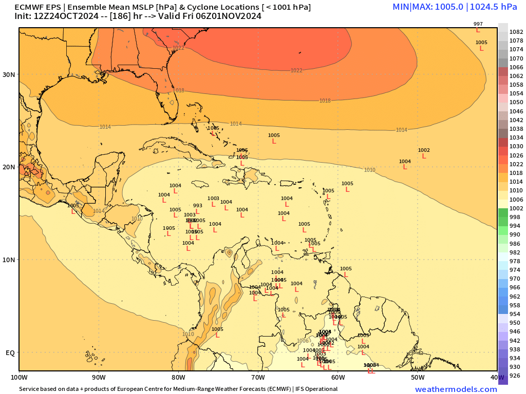
12z Euro continues to show development but still slower than the GFS. Although aligns with the GFS with genesis track close to Jamaica. CMC is the slowest now of the three.

Last edited by blp on Thu Oct 24, 2024 1:27 pm, edited 4 times in total.
2 likes
The following post is NOT an official forecast and should not be used as such. It is just the opinion of the poster and may or may not be backed by sound meteorological data. It is NOT endorsed by any professional institution including storm2k.org For Official Information please refer to the NHC and NWS products.
-
jlauderdal
- S2K Supporter
- Posts: 7240
- Joined: Wed May 19, 2004 5:46 am
- Location: NE Fort Lauderdale
- Contact:
Re: 2024 Global Model Runs Discussion (Out thru day 16)
Inside of 240, I'm becoming interested. Today is the anniversary of Wilma, a game-changing storm for SE Florida.
3 likes
-
SFLcane

- S2K Supporter
- Posts: 10281
- Age: 48
- Joined: Sat Jun 05, 2010 1:44 pm
- Location: Lake Worth Florida
Re: 2024 Global Model Runs Discussion (Out thru day 16)
jlauderdal wrote:
Inside of 240, I'm becoming interested. Today is the anniversary of Wilma, a game-changing storm for SE Florida.
more like a little over 100hrs in terms of formation. For now NHC ignoring
1 likes
-
SFLcane
- S2K Supporter
- Posts: 10281
- Age: 48
- Joined: Sat Jun 05, 2010 1:44 pm
- Location: Lake Worth Florida
Re: 2024 Global Model Runs Discussion (Out thru day 16)
EPS now developing in 7-8 day window. Almost time for the NHC to mention in the TWO.
Last edited by SFLcane on Thu Oct 24, 2024 3:00 pm, edited 1 time in total.
5 likes
Re: 2024 Global Model Runs Discussion (Out thru day 16)
toad strangler wrote:Hmmmm… GFS bias?
https://twitter.com/michaelrlowry/status/1849475905694961669?s=46
Ah yes, a multi-model modelcane.

3 likes
-
Cachondo23
- Tropical Storm

- Posts: 131
- Joined: Wed May 25, 2022 5:56 am
Re: 2024 Global Model Runs Discussion (Out thru day 16)
WaveBreaking wrote:chaser1 wrote:WaveBreaking wrote:
Also an added bonus with that WPAC-style additional development down-shear of the storm that you usually see at the peak of typhoon season.
Yeah, that alone seemed really weird to see. Not sure if this would also find itself to continue to deepen while moving west through most of the Caribbean? I question that southward motion given the overall steering flow.
The GFS has this oddly move due south towards Venezuela and then does a 180 while bombing out past 240h and well into fantasy range. And judging by the wind barbs, the entire monsoon trough connected to the storms also moves south before bouncing north. Definitely a pretty wild GFS run especially for a non-happy hour one.
https://i.imgur.com/u40QiU6.gif
What a unique run for that “fantasy” storm in the NE Caribbean, from north to south then back north… what is going on here…
2 likes

Re: 2024 Global Model Runs Discussion (Out thru day 16)
Where is that fall cold front that could help us in Florida?
Gums wonders....
Gums wonders....
0 likes
Who is online
Users browsing this forum: gib and 141 guests