Texas Fall 2024

U.S. & Caribbean Weather Discussions and Severe Weather Events

Moderator: S2k Moderators

Forum rules

The posts in this forum are NOT official forecast and should not be used as such. They are just the opinion of the poster and may or may not be backed by sound meteorological data. They are NOT endorsed by any professional institution or STORM2K.

Help Support Storm2K
Message
Author
User avatar
bubba hotep
S2K Supporter
S2K Supporter
Posts: 5837
Joined: Wed Dec 28, 2016 1:00 am
Location: Collin County Texas

Re: Texas Fall 2024

#441 Postby bubba hotep » Sat Oct 26, 2024 11:07 am

Image

Image
2 likes   
Winter time post are almost exclusively focused on the DFW area.

Brent
S2K Supporter
S2K Supporter
Posts: 38088
Age: 36
Joined: Sun May 16, 2004 10:30 pm
Location: Tulsa Oklahoma
Contact:

Re: Texas Fall 2024

#442 Postby Brent » Sat Oct 26, 2024 11:12 am

Finally some fall weather showing up

Of course our average high is about to be in the 60s so it's nothing unusual for this time of year. We've already had hard freezes by now in other years

Im just glad it might finally rain for real. This has been a ridiculous stretch
2 likes   
#neversummer

Stratton23
Category 5
Category 5
Posts: 2519
Joined: Fri Jul 21, 2023 10:59 pm
Location: Katy, Tx

Re: Texas Fall 2024

#443 Postby Stratton23 » Sat Oct 26, 2024 11:59 am

GFS and CMC keep things on the wetter side through the end if their runs respectively, hopefully this is a long term pattern change
1 likes   

User avatar
Ntxw
Storm2k Moderator
Storm2k Moderator
Posts: 22784
Joined: Wed Oct 21, 2009 6:34 pm
Location: DFW, Texas

Re: Texas Fall 2024

#444 Postby Ntxw » Sat Oct 26, 2024 2:13 pm

This is a good sign.

Image
3 likes   
The above post and any post by Ntxw is NOT an official forecast and should not be used as such. It is just the opinion of the poster and may or may not be backed by sound meteorological data. It is NOT endorsed by any professional institution including Storm2k. For official information, please refer to NWS products.

  Help support Storm2K!
Help Support Storm2K

Stratton23
Category 5
Category 5
Posts: 2519
Joined: Fri Jul 21, 2023 10:59 pm
Location: Katy, Tx

Re: Texas Fall 2024

#445 Postby Stratton23 » Sat Oct 26, 2024 2:38 pm

Looks like the unsettled weather could stick around through the beginning of the 2nd week of november according to noaa, sub tropical jet stream looks to be active, very good sign
0 likes   

Brent
S2K Supporter
S2K Supporter
Posts: 38088
Age: 36
Joined: Sun May 16, 2004 10:30 pm
Location: Tulsa Oklahoma
Contact:

Re: Texas Fall 2024

#446 Postby Brent » Sat Oct 26, 2024 3:16 pm

Stratton23 wrote:Looks like the unsettled weather could stick around through the beginning of the 2nd week of november according to noaa, sub tropical jet stream looks to be active, very good sign


At least through election day it appears and temps are finally much closer to normal consistently(again 40s for lows is normal now)
0 likes   
#neversummer

Stratton23
Category 5
Category 5
Posts: 2519
Joined: Fri Jul 21, 2023 10:59 pm
Location: Katy, Tx

Re: Texas Fall 2024

#447 Postby Stratton23 » Sat Oct 26, 2024 6:06 pm

Man if the 18z GFS is to be believed, we could be in for unsettled and much cooler weather for the next couple of weeks starting next week
1 likes   

User avatar
ravyrn
S2K Supporter
S2K Supporter
Posts: 1000
Age: 42
Joined: Sun Aug 31, 2008 5:10 am
Location: Alderbranch, TX

Re: Texas Fall 2024

#448 Postby ravyrn » Sat Oct 26, 2024 8:00 pm

I was visiting my mom in Maydelle this afternoon and was surprised to have a brief downpour for about five minutes around 6pm. I was surprised as I hadn't seen any rain forecast for today. I am looking forward to the rain next week and hopefully some cooler temperatures.
2 likes   

Brent
S2K Supporter
S2K Supporter
Posts: 38088
Age: 36
Joined: Sun May 16, 2004 10:30 pm
Location: Tulsa Oklahoma
Contact:

Re: Texas Fall 2024

#449 Postby Brent » Sat Oct 26, 2024 8:01 pm

GFS has highs in the 40s here on Election Day :eek: :cold: :flag:

That's gonna be a shock to the system if that verifies
0 likes   
#neversummer

User avatar
Ntxw
Storm2k Moderator
Storm2k Moderator
Posts: 22784
Joined: Wed Oct 21, 2009 6:34 pm
Location: DFW, Texas

Re: Texas Fall 2024

#450 Postby Ntxw » Sun Oct 27, 2024 9:27 am

The last day of October, Halloween, will save us in what could have been a complete shutout of measurable rain. On average October is the second wettest month of the year for us.
1 likes   
The above post and any post by Ntxw is NOT an official forecast and should not be used as such. It is just the opinion of the poster and may or may not be backed by sound meteorological data. It is NOT endorsed by any professional institution including Storm2k. For official information, please refer to NWS products.


  Help support Storm2K!

Help Support Storm2K


User avatar
wxman22
Category 5
Category 5
Posts: 1492
Joined: Mon Jan 30, 2006 12:39 am
Location: Wichita Falls, TX
Contact:

Re: Texas Fall 2024

#451 Postby wxman22 » Sun Oct 27, 2024 9:38 am

Image


Day 4-8 Convective Outlook
NWS Storm Prediction Center Norman OK
0358 AM CDT Sun Oct 27 2024

Valid 301200Z - 041200Z

...DISCUSSION...
...Wednesday/Day 4 and Thursday/Day 5...
An upper-level trough is forecast to move eastward into the central
Rockies and northern Plains on Wednesday, as an associated mid-level
jet translates eastward into the mid Missouri Valley. At the
surface, a cold front is forecast to move east-southeastward across
the Upper Midwest and central Plains. Scattered thunderstorm
development is expected along and ahead of the front during the
afternoon. Sufficient instability combined with strong low-level
flow, and lift associated with the upper-level trough will be
favorable for severe storms across parts of the region.

The most favorable area for severe storms appears to be from north
Texas and Oklahoma northeastward into western and northern Missouri.
GFS forecast soundings along this corridor during the late afternoon
suggest that MLCAPE will peak in the 1000 to 1500 J/kg range. 0-6 km
shear is forecast to be between 40 and 50 knots, with 700-500 mb
lapse in the 7 to 7.5 C/km range. If this environement can
materialize, supercell development with large hail and severe wind
gusts could occur. A chance for very large hail will be possible
with the more intense cells. An isolated tornado threat also appears
possible.

0 likes   

User avatar
wxman22
Category 5
Category 5
Posts: 1492
Joined: Mon Jan 30, 2006 12:39 am
Location: Wichita Falls, TX
Contact:

Re: Texas Fall 2024

#452 Postby wxman22 » Sun Oct 27, 2024 11:00 am

WPC QPF amounts. At least at this time things are looking good for north Texas and points north. :wink:

Image
0 likes   

Stratton23
Category 5
Category 5
Posts: 2519
Joined: Fri Jul 21, 2023 10:59 pm
Location: Katy, Tx

Re: Texas Fall 2024

#453 Postby Stratton23 » Sun Oct 27, 2024 12:38 pm

Looking ahead, ensembles are definitely trending towards cooler/ chillier weather during the first week of november and beyond, with the GFS/ CMC models showing a very impressive high latitude blocking pattern, overall i do think the first couple weeks of november look to stay unsettled with possibly colder conditions going forward
0 likes   

User avatar
Ntxw
Storm2k Moderator
Storm2k Moderator
Posts: 22784
Joined: Wed Oct 21, 2009 6:34 pm
Location: DFW, Texas

Re: Texas Fall 2024

#454 Postby Ntxw » Sun Oct 27, 2024 1:13 pm

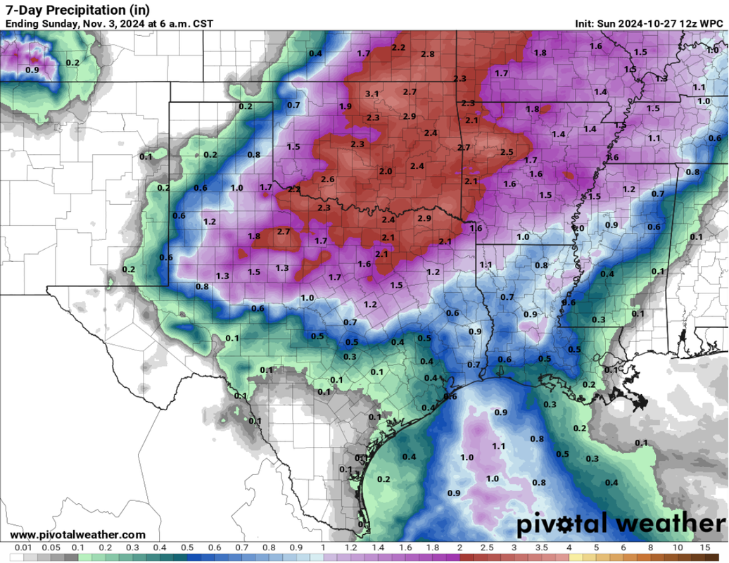
wxman22 wrote:WPC QPF amounts. At least at this time things are looking good for north Texas and points north. :wink:

https://i.postimg.cc/nLkvDM7C/Screenshot-2024-10-27-at-10-52-56-WPC-Forecasts-Pivotal-Weather.png


It's a sign the upper levels are cooling. Eventually with seasonal gradient it will traverse southward with each passing front. It's so late this year due to excessive warmth/stability above.
2 likes   
The above post and any post by Ntxw is NOT an official forecast and should not be used as such. It is just the opinion of the poster and may or may not be backed by sound meteorological data. It is NOT endorsed by any professional institution including Storm2k. For official information, please refer to NWS products.


  Help support Storm2K!

Help Support Storm2K


Brent
S2K Supporter
S2K Supporter
Posts: 38088
Age: 36
Joined: Sun May 16, 2004 10:30 pm
Location: Tulsa Oklahoma
Contact:

Re: Texas Fall 2024

#455 Postby Brent » Sun Oct 27, 2024 2:41 pm

Wouldn't be 2024 without one last run at a record high tomorrow :spam: :roll:

That high of 65 on Halloween is gonna feel amazing
0 likes   
#neversummer

User avatar
Ntxw
Storm2k Moderator
Storm2k Moderator
Posts: 22784
Joined: Wed Oct 21, 2009 6:34 pm
Location: DFW, Texas

Re: Texas Fall 2024

#456 Postby Ntxw » Sun Oct 27, 2024 4:32 pm

Brent wrote:Wouldn't be 2024 without one last run at a record high tomorrow :spam: :roll:

That high of 65 on Halloween is gonna feel amazing


Even average right now feels amazing, we're that desperate.

Ensembles shows some better PNA heading towards mid November, that alongside the MJO moving through more favorable phases. Still ??? on air quality but at least there's that../
2 likes   
The above post and any post by Ntxw is NOT an official forecast and should not be used as such. It is just the opinion of the poster and may or may not be backed by sound meteorological data. It is NOT endorsed by any professional institution including Storm2k. For official information, please refer to NWS products.


  Help support Storm2K!

Help Support Storm2K


Stratton23
Category 5
Category 5
Posts: 2519
Joined: Fri Jul 21, 2023 10:59 pm
Location: Katy, Tx

Re: Texas Fall 2024

#457 Postby Stratton23 » Sun Oct 27, 2024 5:53 pm

GFS 18z has an extended stretch of 50’s and 60’s for highs all across texas with another front in about 10 days , man that would be amazing
0 likes   

User avatar
CaptinCrunch
S2K Supporter
S2K Supporter
Posts: 8728
Age: 57
Joined: Mon Nov 03, 2003 4:33 pm
Location: Kennedale, TX (Tarrant Co.)

Re: Texas Fall 2024

#458 Postby CaptinCrunch » Mon Oct 28, 2024 7:33 am

NWS FTW LONG TERM... /Issued 357 AM CDT Mon Oct 28 2024/
/Wednesday through Sunday/


An amplified longwave trough will be well established across the
Rockies and Intermountain West by Wednesday morning, with a fast
southwesterly upper level flow regime in place across North
Central Texas. Concurrently, pronounced surface to 850 mb
troughing in the lee of the Rockies will be facilitating strong
southerly flow and robust moisture advection from the Gulf. In
response, precipitable values will climb toward the 90th
climatological percentile through the morning hours. The
combination of this favorable moisture environment with the
arrival of strong upward vertical motion ahead of the mean trough
will lead to the development of scattered shower and thunderstorm
activity across the entire area from midday onward. Instability
and forcing for ascent will be favored generally north of I-20
through the afternoon, and the highest PoPs are reflected in these
zones, trending to lower values southward into Central Texas.

As the mean trough ejects from the Rockies late Wednesday and
early Thursday, a cold front will drop southward across the Red
River into North Texas. Convergence ahead of this boundary, aided
by the favorable placement of the right entrance region of the
upper jet, should lead to a focused axis of convection across the
northernmost counties from around dusk Wednesday to midnight.
Instability and shear as advertised by the GFS and NAM solutions
appear sufficient to support the development of some strong to
marginally severe thunderstorms across this general area in the
evening, with some discrete supercells even briefly possible. At
this time, large hail and strong wind gusts would be the primary
threat. The last convective warnings in the Fort Worth forecast
area occurred on September 25th, so it`s prudent for partners and
the public to refresh themselves on their severe weather action
plans as we transition to a more active weather pattern.

Widespread showers and isolated thunderstorms will continue across
most of the forecast area through the pre dawn hours Thursday,
with precipitation ending from west to east as the day
progresses. As the lead upper trough lifts into the Midwest, subsidence
and drying will lead to a brief cessation of rain across most of the
region late Thursday into Thursday night. However, synoptic scale
conditions will again become favorable for scattered shower
activity by Friday, as a new upper trough evolves over the
Southwest U.S. A plentiful moisture regime, coupled with
persistent isentropic ascent, will promote recurrent periods of
light to moderate rainfall from late Friday on through Sunday. The
net effect of this wet pattern from Wednesday onward should lead
to the accumulation of at least 1 to 2 inches of rain across most
of North Central Texas. Some isolated spots will likely approach 3
inch totals by Sunday, though the combination of dry soils and
(mostly) slow rainfall rates should minimize the potential for any
flooding issues.


In addition to the promising news about the rainfall, our
daytime temperatures will also take a pleasant turn toward levels
that are at least a bit closer to those we should be witnessing at
this point in the fall. Widespread highs in the 70s will be the
rule from Thursday into Sunday, though a few lower 80s will creep
back into the picture by the end of the weekend. The combination
of cloud cover, south winds, and an absence of renewed cold air
intrusions will limit our overnight lows to the 60s predominately.
0 likes   

Golfisnteasy7575
Tropical Storm
Tropical Storm
Posts: 152
Joined: Sun Oct 13, 2024 7:25 pm

Re: Texas Fall 2024

#459 Postby Golfisnteasy7575 » Mon Oct 28, 2024 9:39 am

Ntxw wrote:
Brent wrote:Wouldn't be 2024 without one last run at a record high tomorrow :spam: :roll:

That high of 65 on Halloween is gonna feel amazing


Even average right now feels amazing, we're that desperate.

Ensembles shows some better PNA heading towards mid November, that alongside the MJO moving through more favorable phases. Still ??? on air quality but at least there's that../


I think if we can get periods of -epo/wpo this winter, we will have opportunities at winter events. A -ao/nao on its own isn't enough with a unfavorable pacific. A +pna is better east of us than here correct?
0 likes   

Stratton23
Category 5
Category 5
Posts: 2519
Joined: Fri Jul 21, 2023 10:59 pm
Location: Katy, Tx

Re: Texas Fall 2024

#460 Postby Stratton23 » Mon Oct 28, 2024 10:30 am

We would want the PNA to go more negative ( not overly negative though) a +PNA would shove alot of the cold air east of texas
0 likes   


Return to “USA & Caribbean Weather”

Who is online

Users browsing this forum: No registered users and 7 guests