2024 Global Model Runs Discussion (Out thru day 16)

This is the general tropical discussion area. Anyone can take their shot at predicting a storms path.

Moderator: S2k Moderators

Forum rules

The posts in this forum are NOT official forecasts and should not be used as such. They are just the opinion of the poster and may or may not be backed by sound meteorological data. They are NOT endorsed by any professional institution or STORM2K. For official information, please refer to products from the National Hurricane Center and National Weather Service.

Help Support Storm2K
Message
Author
User avatar
blp
Category 5
Category 5
Posts: 2840
Age: 46
Joined: Thu Sep 09, 2004 7:51 pm
Location: Miami, FL
Contact:

Re: 2024 Global Model Runs Discussion (Out thru day 16)

#2441 Postby blp » Thu Oct 24, 2024 5:20 pm

12z Euro Ens.

Image

Image
1 likes   
The following post is NOT an official forecast and should not be used as such. It is just the opinion of the poster and may or may not be backed by sound meteorological data. It is NOT endorsed by any professional institution including storm2k.org For Official Information please refer to the NHC and NWS products.

User avatar
chris_fit
Category 5
Category 5
Posts: 3222
Age: 42
Joined: Wed Sep 10, 2003 11:58 pm
Location: Tampa Bay Area, FL

Re: 2024 Global Model Runs Discussion (Out thru day 16)

#2442 Postby chris_fit » Thu Oct 24, 2024 5:24 pm

Still there on the 18z GFS... Same time of genesis so time frame moving up. Let's see if how much this run ends.
0 likes   

floridasun
Tropical Storm
Tropical Storm
Posts: 196
Joined: Tue Sep 14, 2021 3:59 pm

Re: 2024 Global Model Runs Discussion (Out thru day 16)

#2443 Postby floridasun » Thu Oct 24, 2024 5:42 pm

this nut i leaving south sfl on nov 1dont need mom be her self with bf in her house me worry in LA BAD timing for this be close south fl if get in cone by nov 1 or after i been looking mofels runs their been all over place
0 likes   

User avatar
HurricaneBelle
S2K Supporter
S2K Supporter
Posts: 1169
Joined: Sun Aug 27, 2006 6:12 pm
Location: Clearwater, FL

Re: 2024 Global Model Runs Discussion (Out thru day 16)

#2444 Postby HurricaneBelle » Thu Oct 24, 2024 6:55 pm

chris_fit wrote:Still there on the 18z GFS... Same time of genesis so time frame moving up. Let's see if how much this run ends.


This one hits Haiti going through the Windward Passage, the Bahamas, heads back west and south to hit central Cuba, moves back NE through the Bahamas again and then OTS, nearly clipping Berumuda before being absorbed by a front.
0 likes   

mantis83
Tropical Storm
Tropical Storm
Posts: 198
Joined: Fri Dec 05, 2003 4:47 pm

Re: 2024 Global Model Runs Discussion (Out thru day 16)

#2445 Postby mantis83 » Thu Oct 24, 2024 9:40 pm

HurricaneBelle wrote:
chris_fit wrote:Still there on the 18z GFS... Same time of genesis so time frame moving up. Let's see if how much this run ends.


This one hits Haiti going through the Windward Passage, the Bahamas, heads back west and south to hit central Cuba, moves back NE through the Bahamas again and then OTS, nearly clipping Berumuda before being absorbed by a front.

Misses florida also with the ensembles trending east!
2 likes   

USTropics
Category 5
Category 5
Posts: 2635
Joined: Sun Aug 12, 2007 3:45 am
Location: Florida State University

Re: 2024 Global Model Runs Discussion (Out thru day 16)

#2446 Postby USTropics » Fri Oct 25, 2024 2:45 am

A quick roundup of the 00z models and some thoughts. Genesis increasingly likely, with all of the models showing various levels of development. The CMC and ICON have a dipole setup—typical CAG style development associated with the positive MJO pulse phase (i.e., where we have two areas of low pressure that form, but in this instance the axis is displaced more northeastward):

00z CMC
Image

00z Icon (only goes out to hour 180)
Image

Track still remains largely uncertain, as we can see drastic differences in the upper-level pattern at 240 hours in this animation of the GFS, ECMWF, and CMC:
Image
5 likes   

xironman
S2K Supporter
S2K Supporter
Posts: 2521
Joined: Sun Jun 10, 2007 4:53 pm
Location: NoVA

Re: 2024 Global Model Runs Discussion (Out thru day 16)

#2447 Postby xironman » Fri Oct 25, 2024 5:26 am

I like how the GFS keeps hinting at a Fujiwhara solution, reminds me of the Canadian 10 years ago

Image
1 likes   

User avatar
AJC3
Admin
Admin
Posts: 3998
Age: 61
Joined: Tue Aug 31, 2004 7:04 pm
Location: West Melbourne, Florida
Contact:

Re: 2024 Global Model Runs Discussion (Out thru day 16)

#2448 Postby AJC3 » Fri Oct 25, 2024 9:21 am

Subsequent posts about the system forecast to develop in the SW Caribbean Sea can be posted in the thread started by Luis (cycloneye). Thanks.
3 likes   

User avatar
Steve
S2K Supporter
S2K Supporter
Posts: 9591
Joined: Sat Apr 05, 2003 11:41 pm
Location: Not a state-caster

Re: 2024 Global Model Runs Discussion (Out thru day 16)

#2449 Postby Steve » Sat Oct 26, 2024 8:10 pm

You already know I been talking about the MJO since before Oscar. Climate Forecast System model has us in Phases 2 and 3 from the 9th to the 23rd and 1 and 8 beginning on the 3rd. If so expect at least 2 named systems to probably finish off the western basin 2024.

https://www.cpc.ncep.noaa.gov/products/ ... ncfs.shtml

Euro is not quite as aggressive.

https://www.cpc.ncep.noaa.gov/products/ ... emon.shtml

Bias corrected Australian is similar to CFS but more in the bottom of the circle rather than phases 2-3

https://www.cpc.ncep.noaa.gov/products/ ... bomm.shtml

CFS has occasionally been predictive this season. Keep an eye on the 200 velocity potential forecasts after you run surface models in the coming days and you’ll see if it got it right or was an outlier. Regardless, we are getting at least 1 named system after Halloween which I think you can take to the bank.
2 likes   

User avatar
Teban54
Category 5
Category 5
Posts: 3168
Joined: Sat May 19, 2018 1:19 pm

Re: 2024 Global Model Runs Discussion (Out thru day 16)

#2450 Postby Teban54 » Sat Oct 26, 2024 11:56 pm

Drunk Hour GFS :lol:

Image
3 likes   

MarioProtVI
Category 4
Category 4
Posts: 932
Age: 23
Joined: Sun Sep 29, 2019 7:33 pm
Location: New Jersey

Re: 2024 Global Model Runs Discussion (Out thru day 16)

#2451 Postby MarioProtVI » Sun Oct 27, 2024 1:11 am

Teban54 wrote:Drunk Hour GFS :lol:

https://i.postimg.cc/SRYPcMzj/image.png

That run is probably the only way 2024 would brute force itself to 200 ACE, given the 0/30 probably produces 20-30 here, the cutoff system becoming a TC (and regenerating actually!) and then meandering around the subtropics while eventually becoming another major probably another 20 and the third system (a hurricane but probably not long lived), another 5 or so, which would be a total of 45-55 additional ACE on top of the 145 right now. That run would put us at 18-13-6 and around 185-200 ACE, which would miraculously be in range of the original predicted forecasts. I don’t think we’ll get 3 hurricanes, but with the 2020-like MJO pulse coming (and what 2020 did there) and what this season has done since late September, I’m not ruling anything out.
5 likes   

User avatar
WaveBreaking
Category 2
Category 2
Posts: 561
Joined: Sun Jun 30, 2024 11:33 am
Location: US

Re: 2024 Global Model Runs Discussion (Out thru day 16)

#2452 Postby WaveBreaking » Sun Oct 27, 2024 11:47 am

Main models showing some subtropical/tropical development due to instant-occlusion cyclogenesis over adequate (~21°C) SSTs.

Image
Image
Image
Image


Image
Image
Source: Bader, et al.
Last edited by WaveBreaking on Sun Oct 27, 2024 12:33 pm, edited 1 time in total.
2 likes   
I am NOT a professional meteorologist, so take all of my posts with a grain of salt. My opinions are mine and mine alone.

User avatar
Hurricane2022
Category 5
Category 5
Posts: 1496
Joined: Tue Aug 23, 2022 11:38 pm
Location: Araçatuba, Brazil

Re: 2024 Global Model Runs Discussion (Out thru day 16)

#2453 Postby Hurricane2022 » Sun Oct 27, 2024 12:05 pm

Looks like this guy will steal the name "Patsy" from that future Carib big one.
3 likes   
Sorry for the bad English sometimes...!
For reliable and detailed information for any meteorological phenomenon, please consult the National Hurricane Center, Joint Typhoon Warning Center , or your local Meteo Center.

--------

Una cvm Christo, pro Christo, et in Christo. Sit nomen Domini benedictvm.

User avatar
ConvergenceZone
Category 5
Category 5
Posts: 5194
Joined: Fri Jul 29, 2005 1:40 am
Location: Northern California

Re: 2024 Global Model Runs Discussion (Out thru day 16)

#2454 Postby ConvergenceZone » Mon Oct 28, 2024 1:12 am

Lots of folks were saying that this would be a back loaded season compared to a normal season. I guess we will have to wait and see if that's true. I mean October is normally fairly active anyway, since it's not that far from the September Peak. So I guess when they say backloaded they mean late October and November. I guess we will see if that's true.
0 likes   

User avatar
sasha_B
Tropical Depression
Tropical Depression
Posts: 59
Age: 24
Joined: Sun Jun 30, 2024 4:32 pm
Location: Charleston, SC

Re: 2024 Global Model Runs Discussion (Out thru day 16)

#2455 Postby sasha_B » Mon Oct 28, 2024 1:47 am

ConvergenceZone wrote:Lots of folks were saying that this would be a back loaded season compared to a normal season. I guess we will have to wait and see if that's true. I mean October is normally fairly active anyway, since it's not that far from the September Peak. So I guess when they say backloaded they mean late October and November. I guess we will see if that's true.


I mean, it's already fair to call it backloaded just on the basis of how much more active October has been this year relative to the typical peak months of August and September, even if Beryl is a pretty substantial 'counterweight' on the front end. In terms of ACE (not the best metric, but i think it works here), October 2024 was as active as August 2024 and September 2024 combined, and generated more than 3x the 1991-2020 climatological norm for the month; anything we see from here on out will just be pushing the load further back.
9 likes   

User avatar
ConvergenceZone
Category 5
Category 5
Posts: 5194
Joined: Fri Jul 29, 2005 1:40 am
Location: Northern California

Re: 2024 Global Model Runs Discussion (Out thru day 16)

#2456 Postby ConvergenceZone » Mon Oct 28, 2024 11:38 am

sasha_B wrote:
ConvergenceZone wrote:Lots of folks were saying that this would be a back loaded season compared to a normal season. I guess we will have to wait and see if that's true. I mean October is normally fairly active anyway, since it's not that far from the September Peak. So I guess when they say backloaded they mean late October and November. I guess we will see if that's true.


I mean, it's already fair to call it backloaded just on the basis of how much more active October has been this year relative to the typical peak months of August and September, even if Beryl is a pretty substantial 'counterweight' on the front end. In terms of ACE (not the best metric, but i think it works here), October 2024 was as active as August 2024 and September 2024 combined, and generated more than 3x the 1991-2020 climatological norm for the month; anything we see from here on out will just be pushing the load further back.


Fair enough. Then I think it's fair to say that just the first half of October would be backloaded since it's been relatively quiet since then. We might be one or two more out to sea storms the rest of the season and that's pretty normal as we do often get a storm or two form in late October and November.
0 likes   

zzzh
Category 3
Category 3
Posts: 833
Joined: Thu Sep 02, 2021 1:13 pm

Re: 2024 Global Model Runs Discussion (Out thru day 16)

#2457 Postby zzzh » Tue Oct 29, 2024 1:22 pm

Image
Image
Image
In addition to the west Caribbean AOI, EC, GFS and CMC all have signals on a low latitude wave just east of the Caribbean at day 10 frame.
5 likes   

User avatar
Steve
S2K Supporter
S2K Supporter
Posts: 9591
Joined: Sat Apr 05, 2003 11:41 pm
Location: Not a state-caster

Re: 2024 Global Model Runs Discussion (Out thru day 16)

#2458 Postby Steve » Tue Oct 29, 2024 8:59 pm

GFS 18z is nuts. I’m not much following Caribbean thread yet because there is plenty of time. Caribbean system gets in the Gulf, stalls briefly, weakens and then gets picked up by a low latitude conus trough only to merge and fujiwara with the low crossing Cuba. It all looks too weak because that’s almost sandy to the south but a low eating two tropical systems? Some MJO models have us in 2/3 until mid November. While MJO in November isn’t the same thing as June-October, you still get low pressures and storms in 2/3.
4 likes   

User avatar
chaser1
S2K Supporter
S2K Supporter
Posts: 5406
Age: 64
Joined: Sat Oct 15, 2005 5:59 pm
Location: Longwood, Fl

Re: 2024 Global Model Runs Discussion (Out thru day 16)

#2459 Postby chaser1 » Wed Oct 30, 2024 2:59 am

Just as a reminder, exactly "which" particular models were forecasting the MJO to be enhancing 8 & 1 for the last few days of October and first week of November? Looking at Satellite, Caribbean basin conditions look rather volatile with nothing suggestive of impending development. Furthermore, model support for the SW Caribbean development has really dropped off. I wouldn't right-off November altogether but I'm beginning to think that the Atlantic's last "best shot" to produce an impactfull TC may have passed. My guess is that NHC may lower its TWO for the Southwest Caribbean to 0/20 at 8:00 am.

I just wish we had a Florida sweeping cold front to celebrate the season end.
1 likes   
Andy D

(For official information, please refer to the NHC and NWS products.)

User avatar
Steve
S2K Supporter
S2K Supporter
Posts: 9591
Joined: Sat Apr 05, 2003 11:41 pm
Location: Not a state-caster

Re: 2024 Global Model Runs Discussion (Out thru day 16)

#2460 Postby Steve » Wed Oct 30, 2024 8:26 am

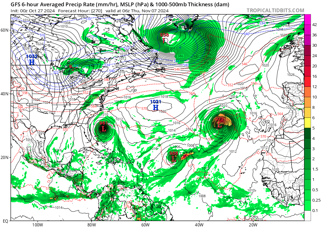
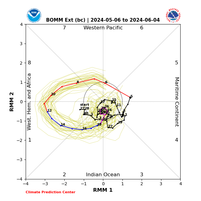
chaser1 wrote:Just as a reminder, exactly "which" particular models were forecasting the MJO to be enhancing 8 & 1 for the last few days of October and first week of November? Looking at Satellite, Caribbean basin conditions look rather volatile with nothing suggestive of impending development. Furthermore, model support for the SW Caribbean development has really dropped off. I wouldn't right-off November altogether but I'm beginning to think that the Atlantic's last "best shot" to produce an impactfull TC may have passed. My guess is that NHC may lower its TWO for the Southwest Caribbean to 0/20 at 8:00 am.

I just wish we had a Florida sweeping cold front to celebrate the season end.


Primarily the CFS and Australian, but almost all of them got to the edge of 7/8 today or tomorrow. This is what we have as of now:

GEFS Bias Corrected
Image

CFSv2
Image

EC Bias Corrected
Image

Australian Bias Corrected
Image
^^ 2 days ago
4 likes   


Return to “Talkin' Tropics”

Who is online

Users browsing this forum: Google Adsense [Bot], Kennethb and 72 guests