
https://x.com/ndgmetchef/status/1850570815986696377
Low Pressure developing in the Southwest Caribbean Sea (Is Invest 97L)
Moderator: S2k Moderators
Forum rules

The posts in this forum are NOT official forecasts and should not be used as such. They are just the opinion of the poster and may or may not be backed by sound meteorological data. They are NOT endorsed by any professional institution or STORM2K. For official information, please refer to products from the National Hurricane Center and National Weather Service.

Re: Low Pressure to develop in the Southwest Caribbean Sea (0/30)
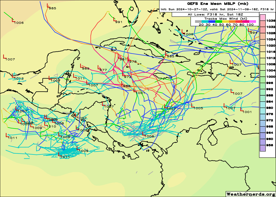
Today's 12z GFS shows a much weaker solution than the two preceding runs, so I think it's still too soon to say that model-forecast intensity is trending back up, but regardless, the EPS is coming closer to agreement with the GEFS re:number of ensemble members that take this somewhere, and the 10/31~11/01 timeframe that the GFS has been set on is getting closer, so I wouldn't be surprised to see the development chances on the TWO hold steady or even go up this evening. Notably, the CMC now seems to be on board with the GFS's insistence on the disturbance eventually becoming a strong TC, although it does show the initial low-pressure area taking longer to get organised.
0 likes
-
Emmett_Brown

- Category 5

- Posts: 1433
- Joined: Wed Aug 24, 2005 9:10 pm
- Location: Sarasota FL
Re: Low Pressure to develop in the Southwest Caribbean Sea (0/30)
12Z Canadian still bullish
1 likes
-
WeatherBoy2000
- Category 1

- Posts: 463
- Joined: Mon Apr 10, 2023 9:29 am
Re: Low Pressure to develop in the Southwest Caribbean Sea (0/30)
sasha_B wrote:Today's 12z GFS shows a much weaker solution than the two preceding runs, so I think it's still too soon to say that model-forecast intensity is trending back up, but regardless, the EPS is coming closer to agreement with the GEFS re:number of ensemble members that take this somewhere, and the 10/31~11/01 timeframe that the GFS has been set on is getting closer, so I wouldn't be surprised to see the development chances on the TWO hold steady or even go up this evening. Notably, the CMC now seems to be on board with the GFS's insistence on the disturbance eventually becoming a strong TC, although it does show the initial low-pressure area taking longer to get organised.
I don't think the gfs is trending in any direction outside development occurring, it's been and still remains all over the place in regard to track and intensity.
2 likes
-
cycloneye

- Admin

- Posts: 149686
- Age: 69
- Joined: Thu Oct 10, 2002 10:54 am
- Location: San Juan, Puerto Rico
Re: Low Pressure to develop in the Southwest Caribbean Sea (0/40)
Up to 40%.

Tropical Weather Outlook
NWS National Hurricane Center Miami FL
200 PM EDT Sun Oct 27 2024
For the North Atlantic...Caribbean Sea and the Gulf of Mexico:
1. Southwestern Caribbean Sea:
A broad area of low pressure is likely to develop over the
southwestern Caribbean Sea in a few days. Gradual development is
possible thereafter, and a tropical depression could form late this
week or over the weekend when the system begins to drift northward
or northeastward over the southwestern and south-central Caribbean
Sea.
* Formation chance through 48 hours...low...near 0 percent.
* Formation chance through 7 days...medium...40 percent.
Forecaster Cangialosi
5 likes
Visit the Caribbean-Central America Weather Thread where you can find at first post web cams,radars
and observations from Caribbean basin members Click Here
and observations from Caribbean basin members Click Here

Re: Low Pressure to develop in the Southwest Caribbean Sea (0/40)
WeatherBoy2000 wrote:sasha_B wrote:Today's 12z GFS shows a much weaker solution than the two preceding runs, so I think it's still too soon to say that model-forecast intensity is trending back up, but regardless, the EPS is coming closer to agreement with the GEFS re:number of ensemble members that take this somewhere, and the 10/31~11/01 timeframe that the GFS has been set on is getting closer, so I wouldn't be surprised to see the development chances on the TWO hold steady or even go up this evening. Notably, the CMC now seems to be on board with the GFS's insistence on the disturbance eventually becoming a strong TC, although it does show the initial low-pressure area taking longer to get organised.
I don't think the gfs is trending in any direction outside development occurring, it's been and still remains all over the place in regard to track and intensity.
The GFS’ intensity is very dependent on how much this disturbance interacts with another disturbance just north of the Greater Antilles. It could be overdoing the interaction, like it did with pre-Milton and the eastern Gulf low.
5 likes
Irene '11 Sandy '12 Hermine '16 5/15/2018 Derecho Fay '20 Isaias '20 Elsa '21 Henri '21 Ida '21
I am only a meteorology enthusiast who knows a decent amount about tropical cyclones. Look to the professional mets, the NHC, or your local weather office for the best information.
I am only a meteorology enthusiast who knows a decent amount about tropical cyclones. Look to the professional mets, the NHC, or your local weather office for the best information.
-
gatorcane

- S2K Supporter

- Posts: 23708
- Age: 48
- Joined: Sun Mar 13, 2005 3:54 pm
- Location: Boca Raton, FL
Re: Low Pressure to develop in the Southwest Caribbean Sea (0/40)
Emmett_Brown wrote:12Z Canadian still bullish
2 likes
-
WaveBreaking

- Category 2

- Posts: 727
- Joined: Sun Jun 30, 2024 11:33 am
- Location: US
Re: Low Pressure to develop in the Southwest Caribbean Sea (0/40)
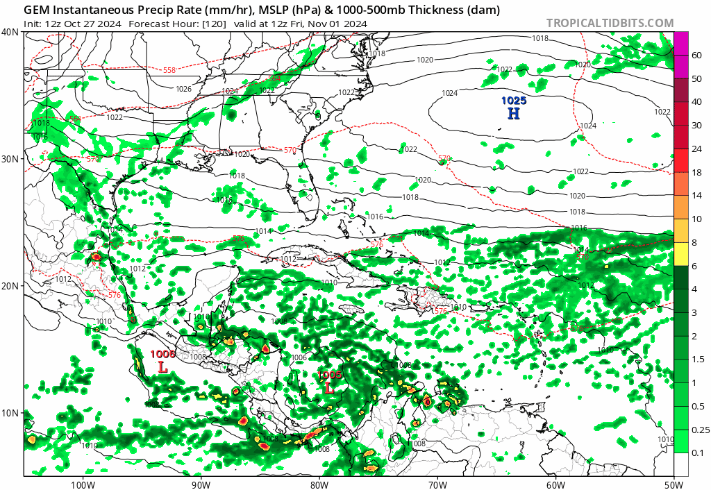
gatorcane wrote:Emmett_Brown wrote:12Z Canadian still bullish
https://i.postimg.cc/WbCkfCQ8/gem-mslp-pcpn-watl-fh120-240.gif
Never seen the Canadian get that low before in terms of pressure
2 likes
I am NOT a professional meteorologist, so take all of my posts with a grain of salt. My opinions are mine and mine alone.
-
WeatherBoy2000
- Category 1
- Posts: 463
- Joined: Mon Apr 10, 2023 9:29 am
Re: Low Pressure to develop in the Southwest Caribbean Sea (0/40)
aspen wrote:WeatherBoy2000 wrote:sasha_B wrote:Today's 12z GFS shows a much weaker solution than the two preceding runs, so I think it's still too soon to say that model-forecast intensity is trending back up, but regardless, the EPS is coming closer to agreement with the GEFS re:number of ensemble members that take this somewhere, and the 10/31~11/01 timeframe that the GFS has been set on is getting closer, so I wouldn't be surprised to see the development chances on the TWO hold steady or even go up this evening. Notably, the CMC now seems to be on board with the GFS's insistence on the disturbance eventually becoming a strong TC, although it does show the initial low-pressure area taking longer to get organised.
I don't think the gfs is trending in any direction outside development occurring, it's been and still remains all over the place in regard to track and intensity.
The GFS’ intensity is very dependent on how much this disturbance interacts with another disturbance just north of the Greater Antilles. It could be overdoing the interaction, like it did with pre-Milton and the eastern Gulf low.
Yeah I've noticed on the weaker runs it interacts more with this secondary system. There's also the question if this secondary system will even be notable, the nhc doesn't have anything marked there. The cmc shows a straightforward solution where it's a non-factor and we end up with a typical late season Caribbean monster.
5 likes
Re: Low Pressure to develop in the Southwest Caribbean Sea (0/40)
Hypercane_Kyle wrote:Seems likely the season has one more punch to it. Let's just hope it doesn't target Florida again.
I agree....I hope our friends in Florida do not have to suffer thru another cyclone....I do not trust systems this season that have repeatedly formed in the NW Caribbean...the NHC outlook states this system will track northward or northeastward...I realize it's early in the evolution of this system...to say one way or another if Florida will be impacted or not...I have no idea what players are in action that control the steering of what eventually may become a cyclone....but if I live in Florida...I am watching the progress of this system....again....I hope this stays only a rainmaker....wherever it goes...
2 likes
-
gatorcane
- S2K Supporter
- Posts: 23708
- Age: 48
- Joined: Sun Mar 13, 2005 3:54 pm
- Location: Boca Raton, FL
Re: Low Pressure to develop in the Southwest Caribbean Sea (0/40)
12Z Euro doesn't really consolidate it but brings in NE then turns it NW towards the NW Caribbean, similar to the CMC, with the CMC being much stronger. I think the 12Z GFS is way too far east since the Euro and CMC show a similar upper air pattern.
2 likes

Re: Low Pressure to develop in the Southwest Caribbean Sea (0/40)
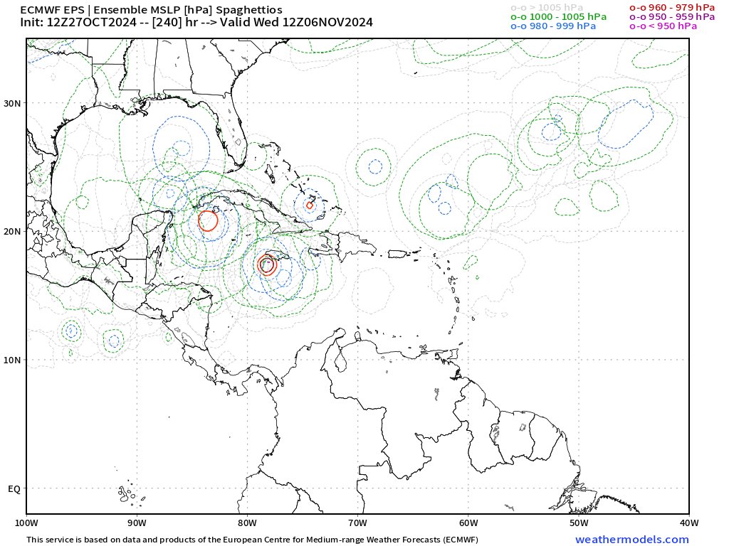
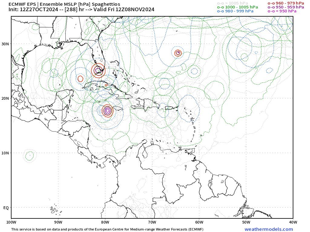
SFLcane wrote:Oh oh...
https://i.postimg.cc/L8L8Q7pj/bbbb.jpg
https://i.postimg.cc/L8L8Q7pj/bbbb.jpg
Can you please describe this illustration?.....what does this show?....thanks!...
0 likes
-
SFLcane

- S2K Supporter
- Posts: 10281
- Age: 48
- Joined: Sat Jun 05, 2010 1:44 pm
- Location: Lake Worth Florida
Re: Low Pressure to develop in the Southwest Caribbean Sea (0/40)
underthwx wrote:SFLcane wrote:Oh oh...
https://i.postimg.cc/L8L8Q7pj/bbbb.jpg
https://i.postimg.cc/L8L8Q7pj/bbbb.jpg
Can you please describe this illustration?.....what does this show?....thanks!...
Its the 12z EPS ensembles showing a bend back westward similar to the CMC and GEFS which would certainly makes things rather interesting and the intensity ceiling could also be very high potentially.
0 likes
Re: Low Pressure to develop in the Southwest Caribbean Sea (0/40)
SFLcane wrote:underthwx wrote:SFLcane wrote:Oh oh...
https://i.postimg.cc/L8L8Q7pj/bbbb.jpg
https://i.postimg.cc/L8L8Q7pj/bbbb.jpg
Can you please describe this illustration?.....what does this show?....thanks!...
Its the 12z EPS ensembles showing a bend back westward similar to the CMC and GEFS which would certainly makes things rather interesting and the intensity ceiling could also be very high potentially.
That is troubling to say the least....Floridians need to remain updated and vigilant with this system....and I am trying not to be an alarmist....but as you indicate with your illustration....this may potentially impact the region in the coming days....the NHC updates will be important....and need to be paid attention to....this particular area of the Carribean has been the origin of weather woes for many this season....I am interested in what the environment will be like....as far as steering patterns....shear....etc....will there be inhibiting conditions aloft...thar will either aid....or limit any potential development?.....alot to consider here.....and I know yall will provide clarity and answers to the many questions on everyone's minds.....thankyou for your reply!....
2 likes
Re: Low Pressure to develop in the Southwest Caribbean Sea (0/40)
If this has already been asked....my apologies....but is this broad low...that is forecast to form in the NW Caribbean....a result of the Central America Gyre?.....this seems to be some sort of a pattern this particular season?....
0 likes
-
WaveBreaking
- Category 2
- Posts: 727
- Joined: Sun Jun 30, 2024 11:33 am
- Location: US
Re: Low Pressure to develop in the Southwest Caribbean Sea (0/40)
underthwx wrote:If this has already been asked....my apologies....but is this broad low...that is forecast to form in the NW Caribbean....a result of the Central America Gyre?.....this seems to be some sort of a pattern this particular season?....
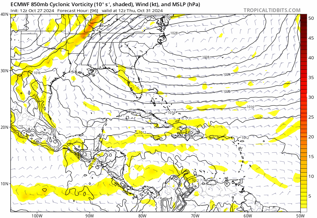
Yeah, the Caribbean disturbance’s vorticity comes from a CAG that’ll spin up in a few days, but the other system that some models show forming near the Greater Antilles comes from a trough dipping down and interacting with the monsoon trough.
3 likes
I am NOT a professional meteorologist, so take all of my posts with a grain of salt. My opinions are mine and mine alone.
Re: Low Pressure to develop in the Southwest Caribbean Sea (0/40)
WaveBreaking wrote:underthwx wrote:If this has already been asked....my apologies....but is this broad low...that is forecast to form in the NW Caribbean....a result of the Central America Gyre?.....this seems to be some sort of a pattern this particular season?....
Yeah, the Caribbean disturbance’s vorticity comes from a CAG that’ll spin up in a few days, but the other system that some models show forming near the Greater Antilles comes from a trough dipping down and interacting with the monsoon trough.
Thanks for your reply....also....I am mistaken when I said the Northwest Carribean....the area of interest is the Southwest Carribean?...my apologies....
0 likes
Who is online
Users browsing this forum: No registered users and 205 guests