Low Pressure developing in the Southwest Caribbean Sea (Is Invest 97L)

This is the general tropical discussion area. Anyone can take their shot at predicting a storms path.

Moderator: S2k Moderators

Forum rules

The posts in this forum are NOT official forecasts and should not be used as such. They are just the opinion of the poster and may or may not be backed by sound meteorological data. They are NOT endorsed by any professional institution or STORM2K. For official information, please refer to products from the National Hurricane Center and National Weather Service.

Help Support Storm2K
Message
Author
User avatar
cycloneye
Admin
Admin
Posts: 143867
Age: 68
Joined: Thu Oct 10, 2002 10:54 am
Location: San Juan, Puerto Rico

Re: Low Pressure to develop in the Southwest Caribbean Sea (0/40)

#121 Postby cycloneye » Mon Oct 28, 2024 7:00 pm

Tropical Weather Outlook
NWS National Hurricane Center Miami FL
800 PM EDT Mon Oct 28 2024

For the North Atlantic...Caribbean Sea and the Gulf of Mexico:

1. Southwestern Caribbean Sea:
A broad area of low pressure is likely to develop over the
southwestern Caribbean Sea in a few days. Gradual development is
possible thereafter, and a tropical depression could form late this
week or over the weekend while the system begins to drift northward
or northeastward toward the central Caribbean Sea.
* Formation chance through 48 hours...low...near 0 percent.
* Formation chance through 7 days...medium...40 percent.


Forecaster Pasch
0 likes   
Visit the Caribbean-Central America Weather Thread where you can find at first post web cams,radars
and observations from Caribbean basin members Click Here

floridasun
Tropical Storm
Tropical Storm
Posts: 196
Joined: Tue Sep 14, 2021 3:59 pm

Re: Low Pressure to develop in the Southwest Caribbean Sea (0/40)

#122 Postby floridasun » Mon Oct 28, 2024 8:27 pm

hope dont come toward south fl i going out town and mom will be here south fl dont need tropical weather hit south fl i hope best to all islands in paths if this form
1 likes   

WeatherBoy2000
Category 1
Category 1
Posts: 280
Joined: Mon Apr 10, 2023 9:29 am

Re: Low Pressure to develop in the Southwest Caribbean Sea (0/40)

#123 Postby WeatherBoy2000 » Mon Oct 28, 2024 8:49 pm

Important to keep in mind about the recent weaker gfs runs:

 https://x.com/WxPatel/status/1851052390138724538


 https://x.com/WxPatel/status/1851052393120584073


3 likes   

User avatar
chaser1
S2K Supporter
S2K Supporter
Posts: 5407
Age: 64
Joined: Sat Oct 15, 2005 5:59 pm
Location: Longwood, Fl

Re: Low Pressure to develop in the Southwest Caribbean Sea (0/40)

#124 Postby chaser1 » Mon Oct 28, 2024 10:01 pm

wxman57 wrote:I've been away from here for the past week as I vacationed in Florida. However, I was monitoring models from there. It does seem that this potential system will not be impacting Florida. It may not even develop. Predicted flow pattern next week would favor either a track west into Central America or northeast, passing well south of Florida. Personally, I'm all for no developing, as I'm in the lead in the office hurricane contest and any development after October 30th, breaks the tie and causes me to lose to a tiebreaker for the second year in a row. I need to pick a later date for the last named storm formation. I have the 28th, my tied coworker has Nov. 2.


Even better than picking a later date might be to wait out everyone else's entry/selection, and pounce on a date immediately after all other chosen "last named storm entries" have been submitted :cheesy:
0 likes   
Andy D

(For official information, please refer to the NHC and NWS products.)

User avatar
cycloneye
Admin
Admin
Posts: 143867
Age: 68
Joined: Thu Oct 10, 2002 10:54 am
Location: San Juan, Puerto Rico

Re: Low Pressure to develop in the Southwest Caribbean Sea (0/40)

#125 Postby cycloneye » Tue Oct 29, 2024 4:47 am

We expect a lot of rain in PR in the next few days with a combination of remnant fronts, a trough and the caribbean low pressure. This from the NWS San Juan:

A broad surface high-pressure building over the western Atlantic is
promoting moderate to fresh east-to-northeast winds across the
northeastern Caribbean. Under these northeasterly steering winds, a
meandering frontal boundary to our north will move over the islands
today through early Wednesday. As shower and cloud coverage
increases over the islands, daytime temperatures will decrease by a
few degrees across Puerto Rico and the U.S. Virgin Islands.
Furthermore, another front will arrive across the area on Thursday
as the surface high centers near Bermuda. Therefore, a wetter
pattern is expected to unfold across the area, with showers and
thunderstorms increasing in areal coverage. In addition, a polar
trough is forecast to move over the region by Thursday, providing
more instability and favorable conditions for thunderstorm
development. Meanwhile, over the southwestern Caribbean Sea, a broad
area of low pressure is forecast to develop, and this will continue
to promote the pooling of tropical moisture under southerly winds
across the Caribbean. Urban and small stream flooding is expected
each day across the islands, with localized flash flooding and
mudslides in areas of steep terrain.


&&

.LONG TERM...Friday through Tuesday...

The most recent guidance continues to suggest a deep mid-to
upper-level trough across the forecast area by the end of the
workweek. This weather feature will create favorable conditions
for thunderstorm development. A broad area of low pressure at the
surface is expected to develop under the influence of the trough,
and a southerly wind flow is expected to prevail from Friday
onwards. This pattern usually favors the pooling of tropical
moisture over the islands.

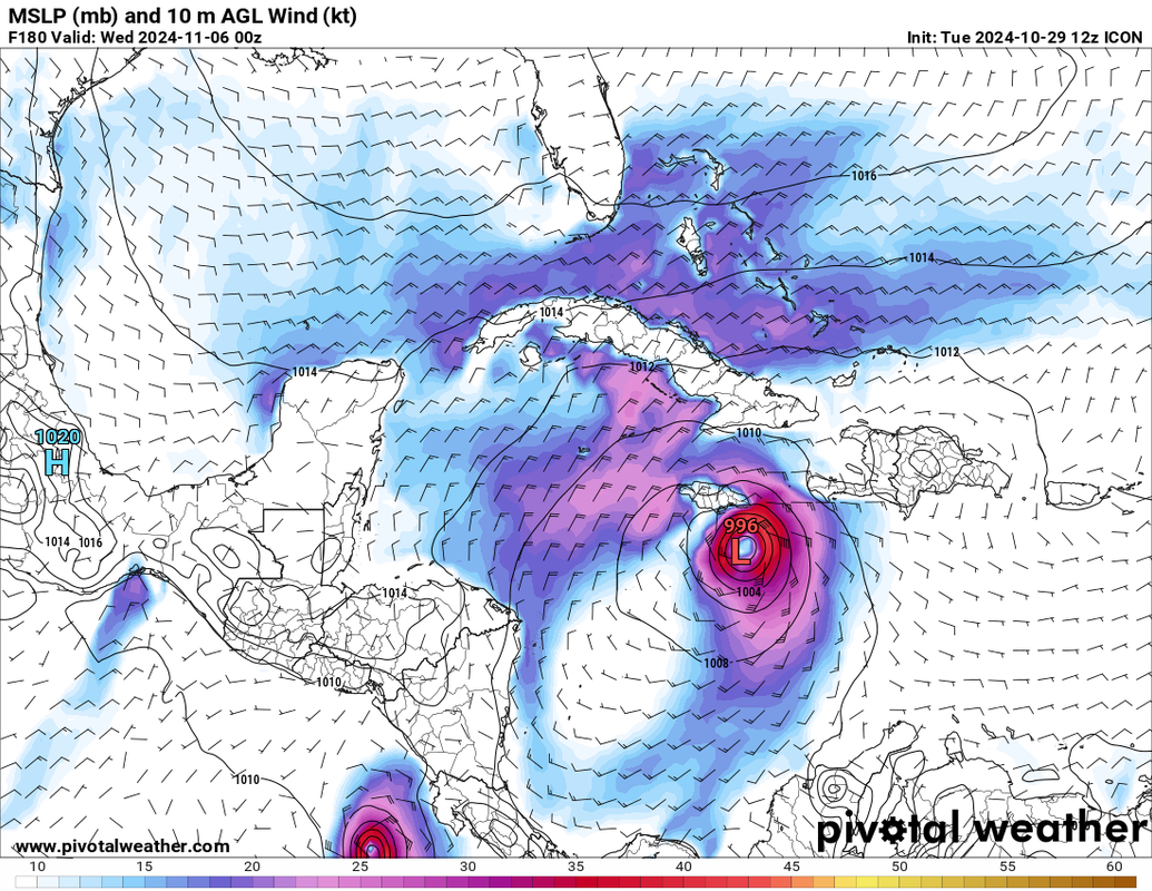
A wet and unstable period could unfold during the end of the
month/beginning of November as the National Hurricane Center is
monitoring an area of low pressure that is likely to develop over
the southwestern Caribbean Sea. They anticipate a gradual
development late this week or over the weekend as the system
begins to drift northward or northeastward and potentially
approach the forecast area. This area of low pressure continues to
have a 40 percent chance of development in the next 7 days.
0 likes   
Visit the Caribbean-Central America Weather Thread where you can find at first post web cams,radars
and observations from Caribbean basin members Click Here

User avatar
wxman57
Moderator-Pro Met
Moderator-Pro Met
Posts: 22951
Age: 67
Joined: Sat Jun 21, 2003 8:06 pm
Location: Houston, TX (southwest)

Re: Low Pressure to develop in the Southwest Caribbean Sea (0/40)

#126 Postby wxman57 » Tue Oct 29, 2024 5:14 am

chaser1 wrote:
wxman57 wrote:I've been away from here for the past week as I vacationed in Florida. However, I was monitoring models from there. It does seem that this potential system will not be impacting Florida. It may not even develop. Predicted flow pattern next week would favor either a track west into Central America or northeast, passing well south of Florida. Personally, I'm all for no developing, as I'm in the lead in the office hurricane contest and any development after October 30th, breaks the tie and causes me to lose to a tiebreaker for the second year in a row. I need to pick a later date for the last named storm formation. I have the 28th, my tied coworker has Nov. 2.


Even better than picking a later date might be to wait out everyone else's entry/selection, and pounce on a date immediately after all other chosen "last named storm entries" have been submitted :cheesy:


Entries are sent in blind - you don't know what anyone else has selected for numbers and last named date.
0 likes   

xironman
S2K Supporter
S2K Supporter
Posts: 2521
Joined: Sun Jun 10, 2007 4:53 pm
Location: NoVA

Re: Low Pressure to develop in the Southwest Caribbean Sea (0/40)

#127 Postby xironman » Tue Oct 29, 2024 5:32 am

Its pretty bad when the CMC seems like the most sane model running
2 likes   

User avatar
cycloneye
Admin
Admin
Posts: 143867
Age: 68
Joined: Thu Oct 10, 2002 10:54 am
Location: San Juan, Puerto Rico

Re: Low Pressure to develop in the Southwest Caribbean Sea (0/40)

#128 Postby cycloneye » Tue Oct 29, 2024 6:26 am

Tropical Weather Outlook
NWS National Hurricane Center Miami FL
800 AM EDT Tue Oct 29 2024

For the North Atlantic...Caribbean Sea and the Gulf of Mexico:

Southwestern Caribbean Sea:
A broad area of low pressure is likely to develop over the
southwestern Caribbean Sea in a couple of days. Gradual development
is possible thereafter, and a tropical depression could form late
this week or over the weekend while the system begins to drift
northward or northeastward toward the central Caribbean Sea.
* Formation chance through 48 hours...low...near 0 percent.
* Formation chance through 7 days...medium...40 percent.

$$
Forecaster Hagen
0 likes   
Visit the Caribbean-Central America Weather Thread where you can find at first post web cams,radars
and observations from Caribbean basin members Click Here

User avatar
ronjon
Category 5
Category 5
Posts: 4811
Joined: Fri Aug 19, 2005 5:17 pm
Location: Hernando Beach, FL

Re: Low Pressure to develop in the Southwest Caribbean Sea (0/40)

#129 Postby ronjon » Tue Oct 29, 2024 7:39 am

Global models both operational and ensembles are converging on low pressure developing in the SW Caribbean in 5 to 7 days. 00z Euro has a broad 1005 mb low in NW Caribbean, 00z ICON has 999 mb low south of JAM, CMC has 998 mb low in NW Caribbean with the GFS, EPS, and Canadian emsembles all on board too. It's still a long way out but the signal is getting stronger for development in the NW Caribbean with the system moving slowly NW or N into the GOM.
0 likes   

canes92
Tropical Storm
Tropical Storm
Posts: 126
Age: 32
Joined: Tue Mar 06, 2018 1:51 pm

Re: Low Pressure to develop in the Southwest Caribbean Sea (0/40)

#130 Postby canes92 » Tue Oct 29, 2024 7:57 am

Seems like the deadline for this storm keeps getting pushed off.
0 likes   

User avatar
CourierPR
Category 5
Category 5
Posts: 1335
Age: 71
Joined: Tue Aug 31, 2004 7:53 pm
Location: Pompano Beach, Florida

Re: Low Pressure to develop in the Southwest Caribbean Sea (0/40)

#131 Postby CourierPR » Tue Oct 29, 2024 8:40 am

ronjon wrote:Global models both operational and ensembles are converging on low pressure developing in the SW Caribbean in 5 to 7 days. 00z Euro has a broad 1005 mb low in NW Caribbean, 00z ICON has 999 mb low south of JAM, CMC has 998 mb low in NW Caribbean with the GFS, EPS, and Canadian emsembles all on board too. It's still a long way out but the signal is getting stronger for development in the NW Caribbean with the system moving slowly NW or N into the GOM.


The NHC says it will move NE or N into the Central Carribbean.
0 likes   

User avatar
AnnularCane
S2K Supporter
S2K Supporter
Posts: 2836
Joined: Thu Jun 08, 2006 9:18 am
Location: Wytheville, VA

Re: Low Pressure to develop in the Southwest Caribbean Sea (0/40)

#132 Postby AnnularCane » Tue Oct 29, 2024 8:46 am

ronjon wrote:Global models both operational and ensembles are converging on low pressure developing in the SW Caribbean in 5 to 7 days. 00z Euro has a broad 1005 mb low in NW Caribbean, 00z ICON has 999 mb low south of JAM, CMC has 998 mb low in NW Caribbean with the GFS, EPS, and Canadian emsembles all on board too. It's still a long way out but the signal is getting stronger for development in the NW Caribbean with the system moving slowly NW or N into the GOM.


Wasn't it supposed to develop this week?
0 likes   
"But it never rained rain. It never snowed snow. And it never blew just wind. It rained things like soup and juice. It snowed mashed potatoes and green peas. And sometimes the wind blew in storms of hamburgers." -- Judi Barrett, Cloudy with a Chance of Meatballs

User avatar
SFLcane
S2K Supporter
S2K Supporter
Posts: 10162
Age: 47
Joined: Sat Jun 05, 2010 1:44 pm
Location: Lake Worth Florida

Re: Low Pressure to develop in the Southwest Caribbean Sea (0/40)

#133 Postby SFLcane » Tue Oct 29, 2024 9:05 am

CourierPR wrote:
ronjon wrote:Global models both operational and ensembles are converging on low pressure developing in the SW Caribbean in 5 to 7 days. 00z Euro has a broad 1005 mb low in NW Caribbean, 00z ICON has 999 mb low south of JAM, CMC has 998 mb low in NW Caribbean with the GFS, EPS, and Canadian emsembles all on board too. It's still a long way out but the signal is getting stronger for development in the NW Caribbean with the system moving slowly NW or N into the GOM.


The NHC says it will move NE or N into the Central Carribbean.


Majority if not all the EPS, GEFS and GEPS ensembles are in the NW caribbean.
0 likes   

User avatar
wzrgirl1
S2K Supporter
S2K Supporter
Posts: 1323
Joined: Sat Sep 04, 2004 6:44 am
Location: Pembroke Pines, Florida

Re: Low Pressure to develop in the Southwest Caribbean Sea (0/40)

#134 Postby wzrgirl1 » Tue Oct 29, 2024 9:09 am

SFLcane wrote:
CourierPR wrote:
ronjon wrote:Global models both operational and ensembles are converging on low pressure developing in the SW Caribbean in 5 to 7 days. 00z Euro has a broad 1005 mb low in NW Caribbean, 00z ICON has 999 mb low south of JAM, CMC has 998 mb low in NW Caribbean with the GFS, EPS, and Canadian emsembles all on board too. It's still a long way out but the signal is getting stronger for development in the NW Caribbean with the system moving slowly NW or N into the GOM.


The NHC says it will move NE or N into the Central Carribbean.


Majority if not all the EPS, GEFS and GEPS ensembles are in the NW caribbean.


That is not good for south florida right? Isn't a cold front supposed to swing down in the middle to end of next week?
0 likes   

User avatar
toad strangler
S2K Supporter
S2K Supporter
Posts: 4543
Joined: Sun Jul 28, 2013 3:09 pm
Location: Earth
Contact:

Re: Low Pressure to develop in the Southwest Caribbean Sea (0/40)

#135 Postby toad strangler » Tue Oct 29, 2024 9:26 am

A snippet from Michael Lowry's most recent update. Regarding the long term...

Since the system could still fester for the next 7 to 10 days, we’ll check back on the trends, but for now this isn’t a worry for us stateside. Even if the system outlasts the high pressure steering to its north, reinforcing wind shear along the shorelines of the continental U.S. will be a stiff impediment to overcome once November rolls in.
0 likes   

User avatar
SFLcane
S2K Supporter
S2K Supporter
Posts: 10162
Age: 47
Joined: Sat Jun 05, 2010 1:44 pm
Location: Lake Worth Florida

Re: Low Pressure to develop in the Southwest Caribbean Sea (0/40)

#136 Postby SFLcane » Tue Oct 29, 2024 9:47 am

wzrgirl1 wrote:
SFLcane wrote:
CourierPR wrote:
The NHC says it will move NE or N into the Central Carribbean.


Majority if not all the EPS, GEFS and GEPS ensembles are in the NW caribbean.


That is not good for south florida right? Isn't a cold front supposed to swing down in the middle to end of next week?


Florida hurricane strikes are quite rare as we get into Nov not impossible. If your looking for any cool down in SFL or FL for that matter you will not enjoy the next 3-4 months. Expecting above normal temps with desert like conditions developing.
0 likes   

User avatar
SFLcane
S2K Supporter
S2K Supporter
Posts: 10162
Age: 47
Joined: Sat Jun 05, 2010 1:44 pm
Location: Lake Worth Florida

Re: Low Pressure to develop in the Southwest Caribbean Sea (0/40)

#137 Postby SFLcane » Tue Oct 29, 2024 10:35 am

Image
1 likes   

WeatherBoy2000
Category 1
Category 1
Posts: 280
Joined: Mon Apr 10, 2023 9:29 am

Re: Low Pressure to develop in the Southwest Caribbean Sea (0/40)

#138 Postby WeatherBoy2000 » Tue Oct 29, 2024 10:41 am

AnnularCane wrote:
ronjon wrote:Global models both operational and ensembles are converging on low pressure developing in the SW Caribbean in 5 to 7 days. 00z Euro has a broad 1005 mb low in NW Caribbean, 00z ICON has 999 mb low south of JAM, CMC has 998 mb low in NW Caribbean with the GFS, EPS, and Canadian emsembles all on board too. It's still a long way out but the signal is getting stronger for development in the NW Caribbean with the system moving slowly NW or N into the GOM.


Wasn't it supposed to develop this week?


It was really only the gfs/gefs that was showing development occurring this week, all the rest of the models were a few days into November. The gfs is known to being too trigger happy with this kind of development.
2 likes   

hipshot
Category 2
Category 2
Posts: 591
Joined: Tue Jul 06, 2010 9:18 pm
Location: Dallas, Texas

Re: Low Pressure to develop in the Southwest Caribbean Sea (0/40)

#139 Postby hipshot » Tue Oct 29, 2024 10:51 am

wzrgirl1 wrote:
SFLcane wrote:
CourierPR wrote:
The NHC says it will move NE or N into the Central Carribbean.


Majority if not all the EPS, GEFS and GEPS ensembles are in the NW caribbean.


That is not good for south florida right? Isn't a cold front supposed to swing down in the middle to end of next week?


I know there is a cold front moving through north Texas Wednesday/Thursday but I don't know how far south it gets.
0 likes   

User avatar
chaser1
S2K Supporter
S2K Supporter
Posts: 5407
Age: 64
Joined: Sat Oct 15, 2005 5:59 pm
Location: Longwood, Fl

Re: Low Pressure to develop in the Southwest Caribbean Sea (0/40)

#140 Postby chaser1 » Tue Oct 29, 2024 10:59 am

AnnularCane wrote:
ronjon wrote:Global models both operational and ensembles are converging on low pressure developing in the SW Caribbean in 5 to 7 days. 00z Euro has a broad 1005 mb low in NW Caribbean, 00z ICON has 999 mb low south of JAM, CMC has 998 mb low in NW Caribbean with the GFS, EPS, and Canadian emsembles all on board too. It's still a long way out but the signal is getting stronger for development in the NW Caribbean with the system moving slowly NW or N into the GOM.


Wasn't it supposed to develop this week?


The GFS recently had gone on a pretty steady roll of consecutive forecasts depicting development of a TS on November 1st. I was subjectively basing that off the forecast time at the point when the model first depicted a 1000 mb low for this disturbance. The 0Z from last night went all the way out to Nov 5 however and then the 6Z this a.m. came back with development on Nov 2, so there is some variability here. Naturally, this is simply "one tool" and no individual model should ever be viewed literally. We'll see if the 12Z run rolling out now more or less reverts to forecasting a 1000 mb low in the Caribbean around the Nov 1/2 time frame, or whether the GFS and other Globals push back development a few days further out. The various ensembles are probably the best tool to determine whether the time frame seems to move closer or if the goal posts are indeed getting further pushed back. One thing I am beginning to see though is that both the GFS and EURO seem to be backing off on any near-term progression of any strong cold front/sharp trough down toward the N. GOM. Seems like the tropics are still trying to enforce its Easterlies pattern just a little bit longer. Whether this verifies will have a lot to do with near to mid-term storm track in the event something does form in the next 4-8 days. Beyond that, steering is just too hard to forecast during this seasonal transition.
0 likes   
Andy D

(For official information, please refer to the NHC and NWS products.)


Return to “Talkin' Tropics”

Who is online

Users browsing this forum: hcane27, Ulf and 97 guests