WPAC: KONG-REY - Post-Tropical
Moderator: S2k Moderators
-
Hurricane2022

- Category 5

- Posts: 2090
- Joined: Tue Aug 23, 2022 11:38 pm
- Location: Araçatuba, Brazil
Re: WPAC: KONG-REY - Typhoon
Gosh.....


2 likes
Sorry for the bad English sometimes...!
For reliable and detailed information for any meteorological phenomenon, please consult the National Hurricane Center, Joint Typhoon Warning Center , or your local Meteo Center.
--------
ECCE OMNIA NOVA FACIAM (Ap 21,5).
For reliable and detailed information for any meteorological phenomenon, please consult the National Hurricane Center, Joint Typhoon Warning Center , or your local Meteo Center.
--------
ECCE OMNIA NOVA FACIAM (Ap 21,5).

Re: WPAC: KONG-REY - Typhoon
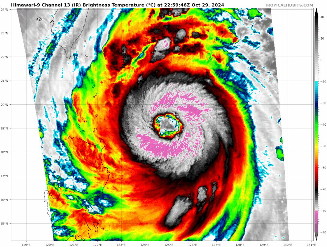
This is one of the most incredible IR presentations I've ever seen. ADT is now at T6.5 and the CI of 6.6 supports 130 kt. ADT was consistent with SAR which showed 109 kt at 09:44 UTC, ADT had 110 kt at that timestamp. As such I think Kong-Rey's current intensity is indeed 120 - 130 kt (DPRINT and AiDT support 116 kt and 124 kt, respectively, but slightly underestimated the system earlier today by 5 kt).


4 likes
-
WaveBreaking

- Category 2

- Posts: 727
- Joined: Sun Jun 30, 2024 11:33 am
- Location: US
Re: WPAC: KONG-REY - Typhoon
And I was just about to accuse this system of being a Bebinca repeat yesterday
0 likes
I am NOT a professional meteorologist, so take all of my posts with a grain of salt. My opinions are mine and mine alone.
-
SconnieCane
- Category 5
- Posts: 1013
- Joined: Thu Aug 02, 2018 5:29 pm
- Location: Madison, WI
Re: WPAC: KONG-REY - Typhoon
Interesting that although the WPAC naming does not operate on six-year cycles like the other main Northern Hemisphere basins, seems we are seeing all the big names from 2018 crop up again this year. Even Krathon, the replacement for Mangkhut, showed up.
1 likes
Re: WPAC: KONG-REY - Typhoon
kevin wrote:This is one of the most incredible IR presentations I've ever seen. ADT is now at T6.5 and the CI of 6.6 supports 130 kt. ADT was consistent with SAR which showed 109 kt at 09:44 UTC, ADT had 110 kt at that timestamp. As such I think Kong-Rey's current intensity is indeed 120 - 130 kt (DPRINT and AiDT support 116 kt and 124 kt, respectively, but slightly underestimated the system earlier today by 5 kt).
https://i.imgur.com/xgvcsBW.jpeg
https://i.imgur.com/mhwu9tL.jpeg
Absolutely a monster cyclone....
0 likes
-
Ed_2001

- Tropical Storm

- Posts: 246
- Age: 24
- Joined: Wed Jun 21, 2017 11:39 pm
- Location: Santa Barbara, CA>>Tampa, FL
Re: WPAC: KONG-REY - Typhoon
After a 7 year storm drought, Taiwan is about to have its 4th MH landfall in the span of 14 months. (plus Krathon’s very unusual west coast strike)
3 likes
The answer my friend, is blowing in the wind...
-
Hurricane2022
- Category 5
- Posts: 2090
- Joined: Tue Aug 23, 2022 11:38 pm
- Location: Araçatuba, Brazil
Re: WPAC: KONG-REY - Typhoon
This is AURA.


So it looks like that we're going to see our 3rd C5 TC in Oct 2024 in the next few hours. Expect this to intensify to atleast 155 kt tomorrow. Pray for Taiwan!
So it looks like that we're going to see our 3rd C5 TC in Oct 2024 in the next few hours. Expect this to intensify to atleast 155 kt tomorrow. Pray for Taiwan!
1 likes
Sorry for the bad English sometimes...!
For reliable and detailed information for any meteorological phenomenon, please consult the National Hurricane Center, Joint Typhoon Warning Center , or your local Meteo Center.
--------
ECCE OMNIA NOVA FACIAM (Ap 21,5).
For reliable and detailed information for any meteorological phenomenon, please consult the National Hurricane Center, Joint Typhoon Warning Center , or your local Meteo Center.
--------
ECCE OMNIA NOVA FACIAM (Ap 21,5).
-
Hurricane2022
- Category 5
- Posts: 2090
- Joined: Tue Aug 23, 2022 11:38 pm
- Location: Araçatuba, Brazil
Re: WPAC: KONG-REY - Typhoon
Holy mesovortices!  https://x.com/cyclonicwx/status/1851373977958052290
https://x.com/xoriwx/status/1851366467582701764
https://x.com/cyclonicwx/status/1851373977958052290
https://x.com/xoriwx/status/1851366467582701764
1 likes
Sorry for the bad English sometimes...!
For reliable and detailed information for any meteorological phenomenon, please consult the National Hurricane Center, Joint Typhoon Warning Center , or your local Meteo Center.
--------
ECCE OMNIA NOVA FACIAM (Ap 21,5).
For reliable and detailed information for any meteorological phenomenon, please consult the National Hurricane Center, Joint Typhoon Warning Center , or your local Meteo Center.
--------
ECCE OMNIA NOVA FACIAM (Ap 21,5).

Re: WPAC: KONG-REY - Typhoon
Hurricane2022 wrote:This is AURA.
https://imageshack.com/i/pocZX8bfp https://imageshack.com/i/pnfGRHArp
So it looks like that we're going to see our 3rd C5 TC in Oct 2024 in the next few hours. Expect this to intensify to atleast 155 kt tomorrow. Pray for Taiwan!
155 kt is likely impossible with this structure. The pressure gradient and wind field are both far too broad to get to upper echelon intensifies. However, it’s gonna make this a very rough storm for Taiwan.
1 likes
Irene '11 Sandy '12 Hermine '16 5/15/2018 Derecho Fay '20 Isaias '20 Elsa '21 Henri '21 Ida '21
I am only a meteorology enthusiast who knows a decent amount about tropical cyclones. Look to the professional mets, the NHC, or your local weather office for the best information.
I am only a meteorology enthusiast who knows a decent amount about tropical cyclones. Look to the professional mets, the NHC, or your local weather office for the best information.
-
Hurricane2022
- Category 5
- Posts: 2090
- Joined: Tue Aug 23, 2022 11:38 pm
- Location: Araçatuba, Brazil
Re: WPAC: KONG-REY - Typhoon
1 likes
Sorry for the bad English sometimes...!
For reliable and detailed information for any meteorological phenomenon, please consult the National Hurricane Center, Joint Typhoon Warning Center , or your local Meteo Center.
--------
ECCE OMNIA NOVA FACIAM (Ap 21,5).
For reliable and detailed information for any meteorological phenomenon, please consult the National Hurricane Center, Joint Typhoon Warning Center , or your local Meteo Center.
--------
ECCE OMNIA NOVA FACIAM (Ap 21,5).
-
WaveBreaking
- Category 2
- Posts: 727
- Joined: Sun Jun 30, 2024 11:33 am
- Location: US
Re: WPAC: KONG-REY - Typhoon
aspen wrote:Hurricane2022 wrote:This is AURA.
https://imageshack.com/i/pocZX8bfp https://imageshack.com/i/pnfGRHArp
So it looks like that we're going to see our 3rd C5 TC in Oct 2024 in the next few hours. Expect this to intensify to atleast 155 kt tomorrow. Pray for Taiwan!
155 kt is likely impossible with this structure. The pressure gradient and wind field are both far too broad to get to upper echelon intensifies. However, it’s gonna make this a very rough storm for Taiwan.
I could see a scenario like Typhoon Nabi from 2005 (140kt/898mbar) where the pressure gets very low, but due to the large eye (Nabi’s was 59mi wide), the winds don’t match up.

0 likes
I am NOT a professional meteorologist, so take all of my posts with a grain of salt. My opinions are mine and mine alone.
-
WaveBreaking
- Category 2
- Posts: 727
- Joined: Sun Jun 30, 2024 11:33 am
- Location: US
Re: WPAC: KONG-REY - Typhoon

1 likes
I am NOT a professional meteorologist, so take all of my posts with a grain of salt. My opinions are mine and mine alone.
-
StormChaser75

- Tropical Storm
- Posts: 101
- Age: 24
- Joined: Sat Feb 06, 2016 4:23 pm
- Location: Corpus Christi TX
- Contact:

-
Hurricane2022
- Category 5
- Posts: 2090
- Joined: Tue Aug 23, 2022 11:38 pm
- Location: Araçatuba, Brazil
Re: WPAC: KONG-REY - Typhoon
----- Current Analysis -----
Date : 29 OCT 2024 Time : 230000 UTC
Lat : 19:02:24 N Lon : 125:03:00 E
CI# /Pressure/ Vmax
6.5 / 926.6mb/127.0kt
Final T# Adj T# Raw T#
6.4 6.5 6.5
Date : 29 OCT 2024 Time : 230000 UTC
Lat : 19:02:24 N Lon : 125:03:00 E
CI# /Pressure/ Vmax
6.5 / 926.6mb/127.0kt
Final T# Adj T# Raw T#
6.4 6.5 6.5
Looks like we're not going to see Kong-Rey becoming a C5 very soon

1 likes
Sorry for the bad English sometimes...!
For reliable and detailed information for any meteorological phenomenon, please consult the National Hurricane Center, Joint Typhoon Warning Center , or your local Meteo Center.
--------
ECCE OMNIA NOVA FACIAM (Ap 21,5).
For reliable and detailed information for any meteorological phenomenon, please consult the National Hurricane Center, Joint Typhoon Warning Center , or your local Meteo Center.
--------
ECCE OMNIA NOVA FACIAM (Ap 21,5).
Re: WPAC: KONG-REY - Typhoon
A blend of the recent intensity estimates (within the last 6 hours) gives a current intensity estimate of 130 - 135 kt.
ADT = 927 mb / 127 kt (CI 6.5)
AiDT = 136 kt
DPRINT = 139 kt
SATCON = 924 mb / 129 kt
Blend = 926 mb / 133 kt
ADT = 927 mb / 127 kt (CI 6.5)
AiDT = 136 kt
DPRINT = 139 kt
SATCON = 924 mb / 129 kt
Blend = 926 mb / 133 kt
1 likes
-
Hypercane_Kyle

- Category 5
- Posts: 3465
- Joined: Sat Mar 07, 2015 7:58 pm
- Location: Cape Canaveral, FL
Re: WPAC: KONG-REY - Typhoon
Wow. Actual donut looking typhoon.

2 likes
My posts are my own personal opinion, defer to the National Hurricane Center (NHC) and other NOAA products for decision making during hurricane season.

Re: WPAC: KONG-REY - Typhoon

3 likes
TC naming lists: retirements and intensity
Most aggressive Advisory #1's in North Atlantic (cr. kevin for starting the list)
Most aggressive Advisory #1's in North Atlantic (cr. kevin for starting the list)
-
Sciencerocks
- Category 5
- Posts: 10193
- Age: 40
- Joined: Thu Jul 06, 2017 1:51 am
-
Sciencerocks
- Category 5
- Posts: 10193
- Age: 40
- Joined: Thu Jul 06, 2017 1:51 am

-
Hurricane2022
- Category 5
- Posts: 2090
- Joined: Tue Aug 23, 2022 11:38 pm
- Location: Araçatuba, Brazil
Re: WPAC: KONG-REY - Typhoon
0 likes
Sorry for the bad English sometimes...!
For reliable and detailed information for any meteorological phenomenon, please consult the National Hurricane Center, Joint Typhoon Warning Center , or your local Meteo Center.
--------
ECCE OMNIA NOVA FACIAM (Ap 21,5).
For reliable and detailed information for any meteorological phenomenon, please consult the National Hurricane Center, Joint Typhoon Warning Center , or your local Meteo Center.
--------
ECCE OMNIA NOVA FACIAM (Ap 21,5).
Who is online
Users browsing this forum: No registered users and 65 guests