
Development is unlikely until Sunday may be later, hence the 0 in the 48 hour out look.
I think NHC will wait for some consistent runs, not just 2 model cycles before going more than 40%.
Low Pressure developing in the Southwest Caribbean Sea (Is Invest 97L)
Moderator: S2k Moderators
Forum rules

The posts in this forum are NOT official forecasts and should not be used as such. They are just the opinion of the poster and may or may not be backed by sound meteorological data. They are NOT endorsed by any professional institution or STORM2K. For official information, please refer to products from the National Hurricane Center and National Weather Service.


Re: Low Pressure to develop in the Southwest Caribbean Sea (0/40)
The models have essentially pushed back development by ~48 hours or so, from Oct. 30-Nov. 1 to Nov. 2-4, which I think justifies maintaining the 7-day TCG probability, but given the way that the CMC and the ICON did eventually come around to this system, and the fact that the EPS and GEFS are both on board (and have stayed that way for a while now), I think that the chances of eventual development are going up even if the time-frame has shifted a little. It doesn't seem to be the same phenomenon as the GFS's habit of continually pushing back development on a phantom system before eventually dropping it - if I recall correctly, it was around the same time the GFS started delaying development that the other models started coming into agreement (re: both the system and the new timeframe). In any case it's now well within the 120-168hr range that every deterministic model except the Euro forecasts a TD/TS; I would not be surprised if the precursor disturbance to this storm (& accompanying Invest designation) were to arrive this weekend.
2 likes
-
tolakram
- Admin

- Posts: 20178
- Age: 62
- Joined: Sun Aug 27, 2006 8:23 pm
- Location: Florence, KY (name is Mark)
Re: Low Pressure to develop in the Southwest Caribbean Sea (0/40)
Models have been all over the place. If they start to show some consistent 7 day development then maybe the second number moves.
7 likes
M a r k
- - - - -
Join us in chat: Storm2K Chatroom Invite. Android and IOS apps also available.
The posts in this forum are NOT official forecasts and should not be used as such. Posts are NOT endorsed by any professional institution or STORM2K.org. For official information and forecasts, please refer to NHC and NWS products.
Re: Low Pressure to develop in the Southwest Caribbean Sea (0/40)
tolakram wrote:Models have been all over the place. If they start to show some consistent 7 day development then maybe the second number moves.
I don't know, the GFS has constantly shown we would start to see lower level vorticity off the coast of Costa Rica on Wednesday afternoon, it does not seem that far off

0 likes
-
Spacecoast

- Category 2

- Posts: 773
- Joined: Thu Aug 31, 2017 2:03 pm
Re: Low Pressure to develop in the Southwest Caribbean Sea (0/40)
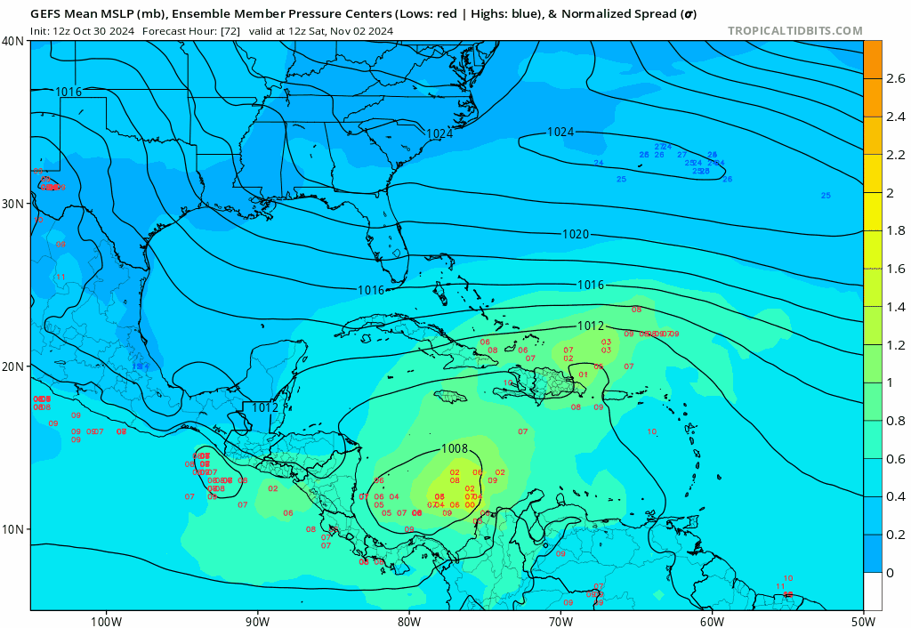
CMC, GFS, & UK:

Shows ~46% genesis probability in ~4 days. The 'probability that each model predicted genesis' is not automatically 100%.
Several ingredients need to be in place for genesis (i.e., MSLP minimum, 850mb relative vorticity, 250-850mb thickness, and 925mb wind speed maxima).
This is in line w/ NHC's 40% probability of formation within "7 days" (really between 49-168 hours).
The 2 day / 7 day formation interval may be fine for Cape Verde longer track cyclones...For CAG's, it would be more helpful to have 2 day / 4 day / 7 day intervals.
A lot can happen between hours 49 and 168.
Last edited by Spacecoast on Wed Oct 30, 2024 7:20 pm, edited 3 times in total.
6 likes

Re: Low Pressure to develop in the Southwest Caribbean Sea (0/40)
Add 12z NAVGEM to CMC, GFS, and ICON showing low pressure in the Yuc straits in about 6 to 7 days.
0 likes

Re: Low Pressure to develop in the Southwest Caribbean Sea (0/40)
cycloneye wrote:No change.Tropical Weather Outlook
NWS National Hurricane Center Miami FL
200 PM EDT Wed Oct 30 2024
For the North Atlantic...Caribbean Sea and the Gulf of Mexico:
Southwestern Caribbean Sea:
A broad area of low pressure is likely to develop over the
southwestern Caribbean Sea by the end of the week. Gradual
development is possible thereafter, and a tropical depression could
form over the weekend or early next week while the system drifts
generally northward over the central or western Caribbean Sea.
* Formation chance through 48 hours...low...near 0 percent.
* Formation chance through 7 days...medium...40 percent.
$$
Forecaster Beven
Hmmm, one subtle change perhaps? Maybe this occured 1 or 2 TWO's ago but there no longer is any reference to an eventual "north or northeast motion".... but now only mentioning a slow northward motion
3 likes
Andy D
(For official information, please refer to the NHC and NWS products.)
(For official information, please refer to the NHC and NWS products.)
-
cycloneye

- Admin
- Posts: 149261
- Age: 69
- Joined: Thu Oct 10, 2002 10:54 am
- Location: San Juan, Puerto Rico
Re: Low Pressure to develop in the Southwest Caribbean Sea (0/40)
Tropical Weather Outlook
NWS National Hurricane Center Miami FL
800 PM EDT Wed Oct 30 2024
For the North Atlantic...Caribbean Sea and the Gulf of Mexico:
Southwestern Caribbean Sea:
A broad area of low pressure is likely to develop over the
southwestern Caribbean Sea by the end of the week. Gradual
development is possible thereafter, and a tropical depression could
form over the weekend or early next week while the system drifts
generally northward or northwestward over the central or western
Caribbean Sea.
* Formation chance through 48 hours...low...near 0 percent.
* Formation chance through 7 days...medium...40 percent.
$$
Forecaster Pasch
0 likes
Visit the Caribbean-Central America Weather Thread where you can find at first post web cams,radars
and observations from Caribbean basin members Click Here
and observations from Caribbean basin members Click Here
Re: Low Pressure to develop in the Southwest Caribbean Sea (0/40)
Pattern change. Latter period motion changed from north to northeast, to then northward, and now "north to northwest".
1 likes
Andy D
(For official information, please refer to the NHC and NWS products.)
(For official information, please refer to the NHC and NWS products.)
-
SouthFLTropics

- Category 5

- Posts: 4258
- Age: 50
- Joined: Thu Aug 14, 2003 8:04 am
- Location: Port St. Lucie, Florida
Re: Low Pressure to develop in the Southwest Caribbean Sea (0/40)
Come on ICON… don’t do this. We’ve had enough in Florida this year!!!
Sent from my iPhone using Tapatalk
Sent from my iPhone using Tapatalk
1 likes
Fourth Generation Florida Native
Personal Storm History: David 79, Andrew 92, Erin 95, Floyd 99, Irene 99, Frances 04, Jeanne 04, Wilma 05, Matthew 16, Irma 17, Ian 22, Nicole 22, Milton 24
Personal Storm History: David 79, Andrew 92, Erin 95, Floyd 99, Irene 99, Frances 04, Jeanne 04, Wilma 05, Matthew 16, Irma 17, Ian 22, Nicole 22, Milton 24
Re: Low Pressure to develop in the Southwest Caribbean Sea (0/40)
chaser1 wrote:cycloneye wrote:No change.Tropical Weather Outlook
NWS National Hurricane Center Miami FL
200 PM EDT Wed Oct 30 2024
For the North Atlantic...Caribbean Sea and the Gulf of Mexico:
Southwestern Caribbean Sea:
A broad area of low pressure is likely to develop over the
southwestern Caribbean Sea by the end of the week. Gradual
development is possible thereafter, and a tropical depression could
form over the weekend or early next week while the system drifts
generally northward over the central or western Caribbean Sea.
* Formation chance through 48 hours...low...near 0 percent.
* Formation chance through 7 days...medium...40 percent.
$$
Forecaster Beven
Hmmm, one subtle change perhaps? Maybe this occured 1 or 2 TWO's ago but there no longer is any reference to an eventual "north or northeast motion".... but now only mentioning a slow northward motion
And also a northwest movement possible?....no mention of a northeastward movement as per earlier outlooks....I noticed that this morning...but its academic at this point...and the implications of a change of wording in the NHC outlook are to me pure speculation to me personally...until they say otherwise.....we all want to know if a cyclone will develop....and of course....if one does form...where is it going to go?.....personally I have not a clue....but yall are the best at what you do.....with the tools yall have....I think the formation chances may nudge upwards over the weekend?....of one thing I am certain....whatever develops...if anything...will be turtle slow to occur....I wish I knew what the NHC knows...
2 likes
-
SouthFLTropics
- Category 5
- Posts: 4258
- Age: 50
- Joined: Thu Aug 14, 2003 8:04 am
- Location: Port St. Lucie, Florida
Re: Low Pressure to develop in the Southwest Caribbean Sea (0/40)
00z Roundup
ICON at 180 hours with a 962mb cyclone in the SE GOM after passing through the Yucatán Channel. Last frames appear to be turning NE towards the FL west coast.
GFS with a weakening cyclone approaching the Florida Panhandle at 186 hours.
CMC brings a developing cyclone into the Yucatán Channel at 162 hours. So far, weaker than 12z.
Sent from my iPhone using Tapatalk
3 likes
Fourth Generation Florida Native
Personal Storm History: David 79, Andrew 92, Erin 95, Floyd 99, Irene 99, Frances 04, Jeanne 04, Wilma 05, Matthew 16, Irma 17, Ian 22, Nicole 22, Milton 24
Personal Storm History: David 79, Andrew 92, Erin 95, Floyd 99, Irene 99, Frances 04, Jeanne 04, Wilma 05, Matthew 16, Irma 17, Ian 22, Nicole 22, Milton 24

Re: Low Pressure to develop in the Southwest Caribbean Sea (0/40)
Look at the size on the CMC. It's huge 

0 likes
The following post is NOT an official forecast and should not be used as such. It is just the opinion of the poster and may or may not be backed by sound meteorological data. It is NOT endorsed by any professional institution including storm2k.org For Official Information please refer to the NHC and NWS products.
-
SouthFLTropics
- Category 5
- Posts: 4258
- Age: 50
- Joined: Thu Aug 14, 2003 8:04 am
- Location: Port St. Lucie, Florida
Re: Low Pressure to develop in the Southwest Caribbean Sea (0/40)
CMC then dive bombs it down into the Yucatán Peninsula… we’ve got three separate global models all showing development with each having a different end game.
Sent from my iPhone using Tapatalk
Sent from my iPhone using Tapatalk
1 likes
Fourth Generation Florida Native
Personal Storm History: David 79, Andrew 92, Erin 95, Floyd 99, Irene 99, Frances 04, Jeanne 04, Wilma 05, Matthew 16, Irma 17, Ian 22, Nicole 22, Milton 24
Personal Storm History: David 79, Andrew 92, Erin 95, Floyd 99, Irene 99, Frances 04, Jeanne 04, Wilma 05, Matthew 16, Irma 17, Ian 22, Nicole 22, Milton 24

Re: Low Pressure to develop in the Southwest Caribbean Sea (0/40)
Tropical Weather Outlook
NWS National Hurricane Center Miami FL
200 AM EDT Thu Oct 31 2024
For the North Atlantic...Caribbean Sea and the Gulf of Mexico:
1. Southwestern Caribbean Sea:
A broad area of low pressure is likely to develop over the
southwestern Caribbean Sea by the end of the week. Gradual
development is possible thereafter, and a tropical depression could
form over the weekend or early next week while the system drifts
generally northward or northwestward over the central or western
Caribbean Sea.
* Formation chance through 48 hours...low...near 0 percent.
* Formation chance through 7 days...medium...50 percent.
Forecaster Blake
Well, whaddya know. It's been stuck at 40% for the longest time!
3 likes

Re: Low Pressure to develop in the Southwest Caribbean Sea (0/50)
06z ICON is quite aggressive, a TC within 3 - 4 days and a quickly strengthening TS at +120.

1 likes
Re: Low Pressure to develop in the Southwest Caribbean Sea (0/50)
Day 2 of persistence, I could see a low chance of development within 48 at 8

1 likes
-
gatorcane

- S2K Supporter

- Posts: 23708
- Age: 48
- Joined: Sun Mar 13, 2005 3:54 pm
- Location: Boca Raton, FL
Re: Low Pressure to develop in the Southwest Caribbean Sea (0/50)
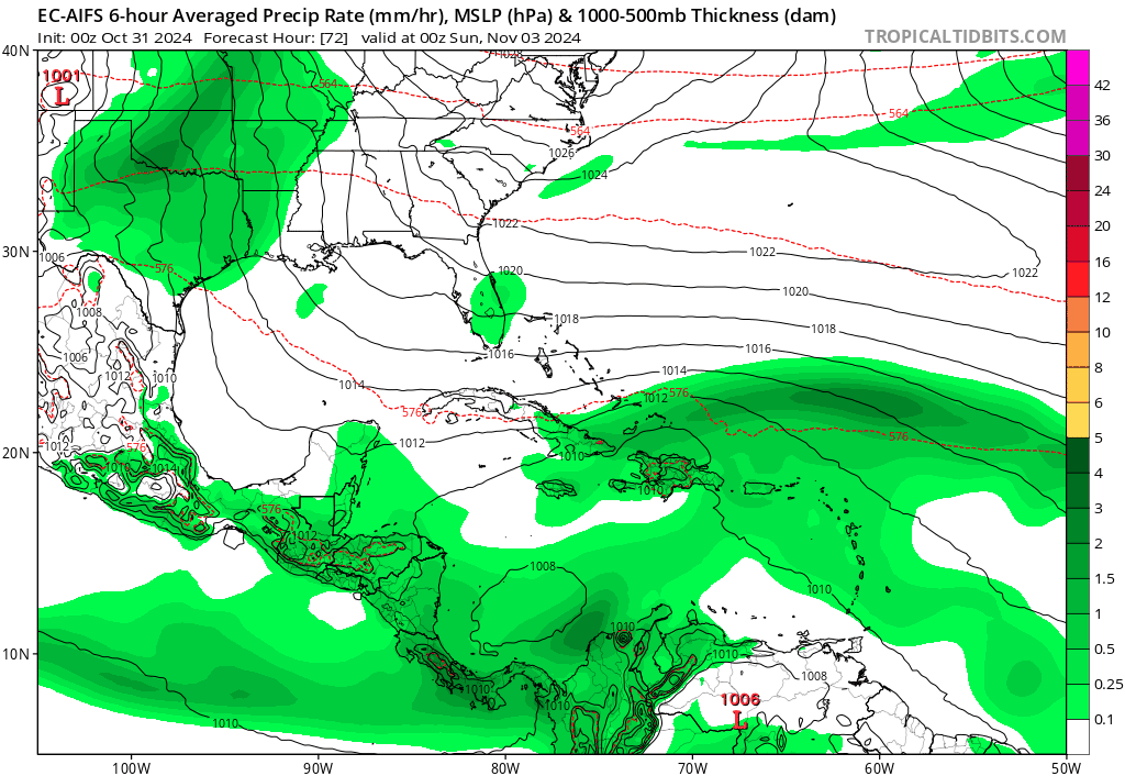
EC-AI with a similar track as ICON into SE GOM then a turn to the NNE into Florida:
3 likes
-
cycloneye
- Admin
- Posts: 149261
- Age: 69
- Joined: Thu Oct 10, 2002 10:54 am
- Location: San Juan, Puerto Rico
Re: Low Pressure to develop in the Southwest Caribbean Sea (0/50)
Tropical Weather Outlook
NWS National Hurricane Center Miami FL
800 AM EDT Thu Oct 31 2024
For the North Atlantic...Caribbean Sea and the Gulf of Mexico:
1. Southwestern Caribbean Sea:
A broad area of low pressure is likely to develop over the
southwestern Caribbean Sea during the next couple of days. Gradual
development is possible thereafter, and a tropical depression could
form over the weekend or early next week while the system drifts
generally northward or northwestward over the central or western
Caribbean Sea.
* Formation chance through 48 hours...low...near 0 percent.
* Formation chance through 7 days...medium...50 percent.
Forecaster Beven
0 likes
Visit the Caribbean-Central America Weather Thread where you can find at first post web cams,radars
and observations from Caribbean basin members Click Here
and observations from Caribbean basin members Click Here
Who is online
Users browsing this forum: No registered users and 86 guests