ATL: RAFAEL - Models
Moderator: S2k Moderators
ATL: RAFAEL - Models
This is a models comment, looking at current intensity models, it shows 97L as a higher end tropical storm? Please correct me if I am wrong.
0 likes

Re: ATL: INVEST 97L - Models
Let's see what the hurricane models do with 97L. Nearly all the global models keep the system as a tropical storm or CAT1.
1 likes

Re: ATL: INVEST 97L - Models
ronjon wrote:Let's see what the hurricane models do with 97L. Nearly all the global models keep the system as a tropical storm or CAT1.
I expect the first couple of hurricane model runs to struggle, especially with it being so disorganized currently, hopefully Inam wrong.
With a potential impact to the Florida Keys as little as 5 days away, we need all the data we can get as there is not much time to prepare.
It is a good sign that none of the operational models are showing a doom storm anymore, and the ensembles are not showing super low pressures any more... the lowest I think they show are around 990mb, with most not falling under 1000mb.
1 likes
-
Blown Away

- S2K Supporter

- Posts: 10253
- Joined: Wed May 26, 2004 6:17 am
Re: ATL: INVEST 97L - Models
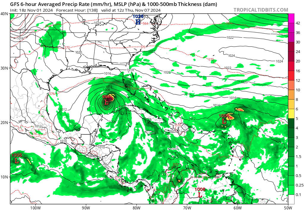
GFS Trend
2 likes
Hurricane Eye Experience: David 79, Irene 99, Frances 04, Jeanne 04, Wilma 05… Hurricane Brush Experience: Andrew 92, Erin 95, Floyd 99, Matthew 16, Irma 17, Ian 22, Nicole 22…
Re: ATL: INVEST 97L - Models
Jr0d wrote:ronjon wrote:Let's see what the hurricane models do with 97L. Nearly all the global models keep the system as a tropical storm or CAT1.
I expect the first couple of hurricane model runs to struggle, especially with it being so disorganized currently, hopefully Inam wrong.
With a potential impact to the Florida Keys as little as 5 days away, we need all the data we can get as there is not much time to prepare.
It is a good sign that none of the operational models are showing a doom storm anymore, and the ensembles are not showing super low pressures any more... the lowest I think they show are around 990mb, with most not falling under 1000mb.
Sounds about right, given the fact that 97L will encounter lower SSTs, and shear over the gulf, should it track into that area, and I think the models are responding to that.
0 likes
-
Stormlover70
- Tropical Storm

- Posts: 194
- Age: 56
- Joined: Fri Jun 21, 2024 5:31 am
- Location: New port richey
-
TallyTracker
- Category 2

- Posts: 787
- Joined: Thu Oct 11, 2018 2:46 pm
Re: ATL: INVEST 97L - Models
The GFS looks fairly consistent with the location of 97L in a few days. What looks very uncertain is the location of the system to the east that forms near Puerto Rico and the norther Leeward Islands. The progression of that system and it’s impact or lack thereof on 97L’s track will be interesting.
3 likes
Fran '96, Georges '98, Gordon '00, Gabrielle '01, Charley '04, Frances '04, Jeanne '04, Barry '07, Fay '08, Debby '12, Matthew '16, Emily '17, Irma '17, Michael ‘18, Elsa ‘21, Fred ‘21, Mindy ‘21, Nicole ‘22, Idalia ‘23, Debby ‘24, Helene ‘24
-
gatorcane

- S2K Supporter
- Posts: 23708
- Age: 48
- Joined: Sun Mar 13, 2005 3:54 pm
- Location: Boca Raton, FL
Re: ATL: INVEST 97L - Models
And there is the more east solution with NE turn in the EGOM showing up in the EC-AIFS as one would expect for this time of year. Huge shift east by the EC-AIFS:

3 likes

Re: ATL: INVEST 97L - Models
The first HAFS-A goes a bit overboard with this one. The other three hurricane models are more reasonable, with HMON showing a system that never reaches hurricane strength, and HWRF & HAFS-B showing a Category 1-2 hurricane.
0 likes
-
cycloneye

- Admin

- Posts: 149715
- Age: 69
- Joined: Thu Oct 10, 2002 10:54 am
- Location: San Juan, Puerto Rico
Re: ATL: INVEST 97L - Models


3 likes
Visit the Caribbean-Central America Weather Thread where you can find at first post web cams,radars
and observations from Caribbean basin members Click Here
and observations from Caribbean basin members Click Here
-
StormWeather

- Category 1

- Posts: 477
- Joined: Wed Jun 05, 2024 2:34 pm
Re: ATL: INVEST 97L - Models
I will be watching that one model that sends 97L to Cat 4. November has had infamous Majors before (Eta and Iota come to mind).
Not to say that Cat 4 is going to happen because it might not.
3 likes
Just an average cyclone tracker
The posts in this forum are NOT official forecasts and should not be used as such. They are just the opinion of the poster and may or may not be backed by sound meteorological data. They are NOT endorsed by any professional institution or storm2k.org. For official information, please refer to the NHC and NWS products
The posts in this forum are NOT official forecasts and should not be used as such. They are just the opinion of the poster and may or may not be backed by sound meteorological data. They are NOT endorsed by any professional institution or storm2k.org. For official information, please refer to the NHC and NWS products
Re: ATL: INVEST 97L - Models
The hurricane models came in much stronger than I expected. My thoughts they would show a struggling low that was battling shear, instead most are showing a hurricane.
Obviously we need more data for better model solutions, which wont happen until the get the HH data tomorrow...
Obviously we need more data for better model solutions, which wont happen until the get the HH data tomorrow...
5 likes
-
Stormlover70
- Tropical Storm
- Posts: 194
- Age: 56
- Joined: Fri Jun 21, 2024 5:31 am
- Location: New port richey
Re: ATL: INVEST 97L - Models
Unfortunately it's the year of surprises.......Jr0d wrote:The hurricane models came in much stronger than I expected. My thoughts they would show a struggling low that was battling shear, instead most are showing a hurricane.
Obviously we need more data for better model solutions, which wont happen until the get the HH data tomorrow...
1 likes
-
eastcoastFL

- Category 5

- Posts: 3996
- Age: 44
- Joined: Thu Apr 12, 2007 12:29 pm
- Location: Palm City, FL
ATL: INVEST 97L - Models
Hurricane models are running now. HWRF spins up a 974mb cane into the big bend.
0 likes
Personal Forecast Disclaimer:
The posts in this forum are NOT official forecast and should not be used as such. They are just the opinion of the poster and may or may not be backed by sound meteorological data. They are NOT endorsed by any professional institution or storm2k.org. For official information, please refer to the NHC and NWS products.
The posts in this forum are NOT official forecast and should not be used as such. They are just the opinion of the poster and may or may not be backed by sound meteorological data. They are NOT endorsed by any professional institution or storm2k.org. For official information, please refer to the NHC and NWS products.
-
eastcoastFL
- Category 5
- Posts: 3996
- Age: 44
- Joined: Thu Apr 12, 2007 12:29 pm
- Location: Palm City, FL
Re: ATL: INVEST 97L - Models
06z HWRF running now. Has 990mb hurricane at 84 hours at roughly 83.5w 24.7n
06z HMON is further west in the middle of the gulf 982mb and very right side heavy
06z HMON is further west in the middle of the gulf 982mb and very right side heavy
0 likes
Personal Forecast Disclaimer:
The posts in this forum are NOT official forecast and should not be used as such. They are just the opinion of the poster and may or may not be backed by sound meteorological data. They are NOT endorsed by any professional institution or storm2k.org. For official information, please refer to the NHC and NWS products.
The posts in this forum are NOT official forecast and should not be used as such. They are just the opinion of the poster and may or may not be backed by sound meteorological data. They are NOT endorsed by any professional institution or storm2k.org. For official information, please refer to the NHC and NWS products.

-
ThunderForce

- Tropical Storm
- Posts: 208
- Age: 26
- Joined: Tue Sep 27, 2022 6:20 pm
- Location: Calhoun County, Florida
Re: ATL: INVEST 97L - Models
Assuming it landfalls at the intensity that the HAFS-A is showing or stronger, that would be unprecedented for November. No major hurricane has hit the United States in November in recorded history to my knowledge.
1 likes
Please refer to the NWS, NHC, SPC or a professional meteorologist for information and decision making during storms.

Re: ATL: INVEST 97L - Models
Joes Saturday summary looked at the MJO which 8/1 doesn’t predict landfalls on the NE Gulf but the verifications do show those to be strong phases across NC/NE FL and S GA. I’m curious to see if it can stay together or if it’s just going to die out over the water midweek as it heads toward the west Gulf as many global models have been indicating. If it takes an eastern/landfall scenario, I think it would be east of Pensacola.
0 likes
-
eastcoastFL
- Category 5
- Posts: 3996
- Age: 44
- Joined: Thu Apr 12, 2007 12:29 pm
- Location: Palm City, FL
Re: ATL: INVEST 97L - Models
Steve wrote:Joes Saturday summary looked at the MJO which 8/1 doesn’t predict landfalls on the NE Gulf but the verifications do show those to be strong phases across NC/NE FL and S GA. I’m curious to see if it can stay together or if it’s just going to die out over the water midweek as it heads toward the west Gulf as many global models have been indicating. If it takes an eastern/landfall scenario, I think it would be east of Pensacola.
Looks like landfall will be heavily dependent on the timing of the next front moving across CONUS. Most of the models show it getting yanked NE eventually
0 likes
Personal Forecast Disclaimer:
The posts in this forum are NOT official forecast and should not be used as such. They are just the opinion of the poster and may or may not be backed by sound meteorological data. They are NOT endorsed by any professional institution or storm2k.org. For official information, please refer to the NHC and NWS products.
The posts in this forum are NOT official forecast and should not be used as such. They are just the opinion of the poster and may or may not be backed by sound meteorological data. They are NOT endorsed by any professional institution or storm2k.org. For official information, please refer to the NHC and NWS products.
-
Hypercane_Kyle

- Category 5
- Posts: 3465
- Joined: Sat Mar 07, 2015 7:58 pm
- Location: Cape Canaveral, FL
Re: ATL: INVEST 97L - Models
12z HAFS-A and HAFS-B goes absolutely nuclear in the Caribbean. Category 4 in 72 hours.
0 likes
My posts are my own personal opinion, defer to the National Hurricane Center (NHC) and other NOAA products for decision making during hurricane season.
Who is online
Users browsing this forum: No registered users and 67 guests