
I posted this on an FB group that is mostly for live-aboards, living on anchors or moorings off the Key West Bight, Wisteria Island and Flemming Key area, folks who are the most vulnerable for a potential impact in hopes they start preparing, securing their boats. With the power boat races there are no open slips at the Marinas currently so those capable of bringing their boat to safe harbor are currently unable.
Many are looking at the Spaghetti Models and believe it will be too far west to be a concern...I would bet they are going to have a rude awakening Wednesday.
If we get a severe impact in Key West, I am blaming whoever's idea it was to feature Robert the Doll in the Fantasy Fest parade a few weeks ago.
ATL: RAFAEL - Post-Tropical - Discussion
Moderator: S2k Moderators
Re: ATL: EIGHTEEN - Potential Tropical Cyclone - Discussion
wxman57 wrote:I'm not buying a 50kt TS offshore SE LA. Models that take it there have it as a remnant low, if that. Lots of SW-WSW shear across central to northern Gulf. I don't think it could survive up there. Also, there's a very good MLC and strong convection around 76W. I think any center will form farther east under that convection.
Hopefully the system will be only a weak rainmaker, And no threats to anyone, many areas in the Southeast are still in recovery mode, after the impacts of 2 cyclones, so I am all for this system to be weak, and exit in a speedy fashion.
Last edited by underthwx on Sun Nov 03, 2024 5:37 pm, edited 3 times in total.
1 likes
-
HurricaneAndre2008

- Category 1

- Posts: 356
- Age: 28
- Joined: Wed Jul 31, 2019 9:51 pm
- Contact:
Re: ATL: EIGHTEEN - Potential Tropical Cyclone - Discussion
Maximum sustained winds are near 35 mph (55 km/h) with higher gusts.
This system is expected to become a tropical depression tonight and
steady strengthening is forecast.
* Formation chance through 48 hours...high...near 100 percent.
* Formation chance through 7 days...high...near 100 percent.
This system is expected to become a tropical depression tonight and
steady strengthening is forecast.
* Formation chance through 48 hours...high...near 100 percent.
* Formation chance through 7 days...high...near 100 percent.
8 likes
Cindy(2005), Katrina(2005), Rita(2005), Erin(2007), Isaac(2012)
Re: ATL: EIGHTEEN - Potential Tropical Cyclone - Discussion
This is an excerpt from NWS Key West Forecast Discussion 5:11 pm:
The National Hurricane Center has begun issuing advisories on
Potential Tropical Cyclone Eighteen (Rafael) in the southwestern
Caribbean Sea to the south of Jamaica. The system is expected to
continue on a northeast motion this evening before taking a more
north motion overnight and then northwest motion thereafter. The
system is expected to become a hurricane as it nears and crosses
western Cuba into the southeastern Gulf of Mexico while slowly
weakening as it continues moving northwestward. The timing for
anticipated impacts to the Keys will be sometime through the
Tuesday night to Wednesday night time frame with the peak of the
event sometime early Wednesday to Wednesday morning. At the very
least, we expect increased rain chances as thundery squalls with
strong gusty winds move through the Keys. Outside of convection,
the Keys can expect very windy conditions.
Looking beyond the mid week period, the forecast once again gets
interesting. The Keys may get to enjoy a few days of calmer
conditions with lower rain chances, though, winds may still
remain elevated. The forecast during the extended remains quite
uncertain with the National Hurricane Center now monitoring a
second disturbance in the western North Atlantic to the north of
Hispaniola and Puerto Rico which may affect the Keys sometime next
weekend. Right now, it has a 20% chance of development over the
next 7 days. The Caribbean and the western North Atlantic
continue to remain a mess of vorticity with lower pressure the
name of the game across the area, and with tropical development
not out of the realm of possibility. Yes, we know it is November,
but the tropics apparently didn`t get the memo. Right now, it is
way too early to look at any specifics, especially with the mid
week threat looming. However, at the very least, we can expect
another period of elevated winds and rain chances. Stay tuned!
2 likes

Re: ATL: EIGHTEEN - Potential Tropical Cyclone - Discussion
GFS is trending for a solid Anti-Cyclone in the N GoM
Chances increasing for a Cat 1 or higher before landfall
Chances increasing for a Cat 1 or higher before landfall
4 likes
-
REDHurricane

- Category 1
- Posts: 438
- Age: 28
- Joined: Sun Jul 03, 2022 2:36 pm
- Location: Northeast Pacific Ocean
Re: ATL: EIGHTEEN - Potential Tropical Cyclone - Discussion
I present another yet poorly made gif of PTC18's evolution:
12 likes

Re: ATL: EIGHTEEN - Potential Tropical Cyclone - Discussion
REDHurricane wrote:I present another yet poorly made gif of PTC18's evolution:
https://media4.giphy.com/media/v1.Y2lkPTc5MGI3NjExMnd2aHlidzlwNTh6czk1b3FvNG91ZWs0eTUxcWRxeDlsampyNzlwYSZlcD12MV9pbnRlcm5hbF9naWZfYnlfaWQmY3Q9Zw/BaLtkx1qAWvDkbTZpq/giphy.gif
If the center is relocated at 75 west wouldn’t that affect the model outcomes?
1 likes
-
AnnularCane

- S2K Supporter

- Posts: 2957
- Joined: Thu Jun 08, 2006 9:18 am
- Location: Wytheville, VA
Re: ATL: EIGHTEEN - Potential Tropical Cyclone - Discussion
REDHurricane wrote:I present another yet poorly made gif of PTC18's evolution:
https://media4.giphy.com/media/v1.Y2lkPTc5MGI3NjExMnd2aHlidzlwNTh6czk1b3FvNG91ZWs0eTUxcWRxeDlsampyNzlwYSZlcD12MV9pbnRlcm5hbF9naWZfYnlfaWQmY3Q9Zw/BaLtkx1qAWvDkbTZpq/giphy.gif
Little fetus curling up.
1 likes
"But it never rained rain. It never snowed snow. And it never blew just wind. It rained things like soup and juice. It snowed mashed potatoes and green peas. And sometimes the wind blew in storms of hamburgers." -- Judi Barrett, Cloudy with a Chance of Meatballs
-
REDHurricane
- Category 1
- Posts: 438
- Age: 28
- Joined: Sun Jul 03, 2022 2:36 pm
- Location: Northeast Pacific Ocean
Re: ATL: EIGHTEEN - Potential Tropical Cyclone - Discussion
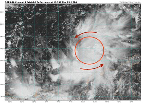
boca wrote:REDHurricane wrote:I present another yet poorly made gif of PTC18's evolution:
https://media4.giphy.com/media/v1.Y2lkPTc5MGI3NjExMnd2aHlidzlwNTh6czk1b3FvNG91ZWs0eTUxcWRxeDlsampyNzlwYSZlcD12MV9pbnRlcm5hbF9naWZfYnlfaWQmY3Q9Zw/BaLtkx1qAWvDkbTZpq/giphy.gif
If the center is relocated at 75 west wouldn’t that affect the model outcomes?
Looking at it again, my circle is likely a degree or so too far to the east, so the actual center is probably closer to 76ºW -- but yeah to my amateur eye it appears to be running east of the current NHC best track position (77.1ºW) for sure
1 likes
-
wxman57

- Moderator-Pro Met

- Posts: 23171
- Age: 68
- Joined: Sat Jun 21, 2003 8:06 pm
- Location: Houston, TX (southwest)
Re: ATL: EIGHTEEN - Potential Tropical Cyclone - Discussion
GCANE wrote:GFS is trending for a solid Anti-Cyclone in the N GoM
Chances increasing for a Cat 1 or higher before landfall
I'm not seeing any upper high over the Gulf in the GFS after tomorrow. Just a digging trof and increasing SW shear.
1 likes
Re: ATL: EIGHTEEN - Potential Tropical Cyclone - Discussion
wxman57 wrote:GCANE wrote:GFS is trending for a solid Anti-Cyclone in the N GoM
Chances increasing for a Cat 1 or higher before landfall
I'm not seeing any upper high over the Gulf in the GFS after tomorrow. Just a digging trof and increasing SW shear.
Is this a bit of bitterness on losing the pool?
8 likes
-
TallyTracker
- Category 2

- Posts: 787
- Joined: Thu Oct 11, 2018 2:46 pm
Re: ATL: EIGHTEEN - Potential Tropical Cyclone - Discussion
This is a classic example of where the track is extremely uncertain after a couple of days. Models are still all over the place. The NHC’s track is just an average currently until the center gets established and models get a better handle of everything. The cone is only statistically where the center tracks 67% of the time. 33% of the time the center is left or right of the cone completely. This is a case where that is way more likely than with many systems. Even though the west coast of FL is outside the cone, the center could head that way if the trough erodes the high faster. Even if the track goes straight north, most rain and moisture is likely to be pulled over the Peninsula and north FL over the coming days.
Another thing I’ve noticed for late-season storms moving north out of the Caribbean, the stronger they are, the more they trend eastward as they feel the tug of the upper-level troughs. Typically storms that buck the trend and try to head west get decapitated and become remnant lows (see Ida 2009). Kate 1985 was a major exception to that though I’d be surprised to get that type of system.
Another thing I’ve noticed for late-season storms moving north out of the Caribbean, the stronger they are, the more they trend eastward as they feel the tug of the upper-level troughs. Typically storms that buck the trend and try to head west get decapitated and become remnant lows (see Ida 2009). Kate 1985 was a major exception to that though I’d be surprised to get that type of system.
11 likes
Fran '96, Georges '98, Gordon '00, Gabrielle '01, Charley '04, Frances '04, Jeanne '04, Barry '07, Fay '08, Debby '12, Matthew '16, Emily '17, Irma '17, Michael ‘18, Elsa ‘21, Fred ‘21, Mindy ‘21, Nicole ‘22, Idalia ‘23, Debby ‘24, Helene ‘24
Re: ATL: EIGHTEEN - Potential Tropical Cyclone - Discussion
Given the long range uncertainties with this system, I expect both the NHC, and yall will be at your finest with this complex system!
1 likes
-
Sciencerocks
- Category 5

- Posts: 10181
- Age: 40
- Joined: Thu Jul 06, 2017 1:51 am

Re: ATL: EIGHTEEN - Potential Tropical Cyclone - Discussion
TallyTracker wrote:This is a classic example of where the track is extremely uncertain after a couple of days. Models are still all over the place. The NHC’s track is just an average currently until the center gets established and models get a better handle of everything. The cone is only statistically where the center tracks 67% of the time. 33% of the time the center is left or right of the cone completely. This is a case where that is way more likely than with many systems. Even though the west coast of FL is outside the cone, the center could head that way if the trough erodes the high faster. Even if the track goes straight north, most rain and moisture is likely to be pulled over the Peninsula and north FL over the coming days.
Another thing I’ve noticed for late-season storms moving north out of the Caribbean, the stronger they are, the more they trend eastward as they feel the tug of the upper-level troughs. Typically storms that buck the trend and try to head west get decapitated and become remnant lows (see Ida 2009). Kate 1985 was a major exception to that though I’d be surprised to get that type of system.
I have to agree with you, it seems to make sense. I won't be surprised to see some eastward nudges in the NHC track, when a true center becomes established, and as the latest NHC update mentions, the environment where PTC 18 is evolving, lends itself to the system for possibly significant intensification, with that said, if I live in Florida, from the Keys, up to the panhandle, perhaps a bit west, I have to watch this carefully.
1 likes

Re: ATL: EIGHTEEN - Potential Tropical Cyclone - Discussion
18 looks pretty disheveled atm. Regardless, this has been a weird year that has highlighted small and fast organizing development. On this limb that I gingerly go out on, I'll predict the following:
-Rafael will have a very small inner core and reach Cat 2 intensity.
- A few deaths will sadly occur in Cuba
-"Rafael" will be retired
- Rafael will make 2nd landfall in Wakulla, Jefferson, or Taylor County Fl as a moderate to strong T.S.
-Tropical Storm Sara will hit Miami-Dade or Monroe County within 48 hr's of Rafael's Florida Landfall
2 likes
Andy D
(For official information, please refer to the NHC and NWS products.)
(For official information, please refer to the NHC and NWS products.)
Re: ATL: EIGHTEEN - Potential Tropical Cyclone - Discussion
Still no defined center so still a PTC, the hurricane hunters mission is over for the night. The models seem to agree that this will consolidate quickly by tomorrow night.
Its looking really ragged right now. Hard to believe this has the potential to be a hurricane in 48 hours..but the low pressure is there and we have seen many storms go from nothing to a beast quickly.
Its looking really ragged right now. Hard to believe this has the potential to be a hurricane in 48 hours..but the low pressure is there and we have seen many storms go from nothing to a beast quickly.
0 likes
Re: ATL: EIGHTEEN - Potential Tropical Cyclone - Discussion
wxman57 wrote:GCANE wrote:GFS is trending for a solid Anti-Cyclone in the N GoM
Chances increasing for a Cat 1 or higher before landfall
I'm not seeing any upper high over the Gulf in the GFS after tomorrow. Just a digging trof and increasing SW shear.
Typically, the SE side of the tail end of a front creates an UL High or more specifically called an Anti-Cyclonic Rossby Wave Break.
The last couple models runs are showing a trend of developing this.
Its all about timing how TD18 and the ARWB interact.
2 likes
-
wxman57
- Moderator-Pro Met
- Posts: 23171
- Age: 68
- Joined: Sat Jun 21, 2003 8:06 pm
- Location: Houston, TX (southwest)
Re: ATL: EIGHTEEN - Potential Tropical Cyclone - Discussion
I think it'll be steadily weakening as it crosses the southern Gulf Thursday, becoming a remnant low late Friday or early Saturday offshore. Remnants moving up the front into SE LA on Saturday. Not much rain with it. More rain with the front than with its remnants. NHC will be reducing that 55kt wind they have at day 5. I have it at 30 kts then.
7 likes
Re: ATL: EIGHTEEN - Potential Tropical Cyclone - Discussion
wxman57 wrote:I think it'll be steadily weakening as it crosses the southern Gulf Thursday, becoming a remnant low late Friday or early Saturday offshore. Remnants moving up the front into SE LA on Saturday. Not much rain with it. More rain with the front than with its remnants. NHC will be reducing that 55kt wind they have at day 5. I have it at 30 kts then.
That sounds good. I hope our friends in the Carribean will be okay. Hopefully PTC 18 will be weaker than forecast, and move on out of there quickly!
1 likes
Who is online
Users browsing this forum: No registered users and 8 guests