2024 Global Model Runs Discussion (Out thru day 16)

This is the general tropical discussion area. Anyone can take their shot at predicting a storms path.

Moderator: S2k Moderators

Forum rules

The posts in this forum are NOT official forecasts and should not be used as such. They are just the opinion of the poster and may or may not be backed by sound meteorological data. They are NOT endorsed by any professional institution or STORM2K. For official information, please refer to products from the National Hurricane Center and National Weather Service.

Help Support Storm2K
Message
Author
WeatherBoy2000
Category 1
Category 1
Posts: 279
Joined: Mon Apr 10, 2023 9:29 am

Re: 2024 Global Model Runs Discussion (Out thru day 16)

#2461 Postby WeatherBoy2000 » Wed Oct 30, 2024 9:09 am

chaser1 wrote:Just as a reminder, exactly "which" particular models were forecasting the MJO to be enhancing 8 & 1 for the last few days of October and first week of November? Looking at Satellite, Caribbean basin conditions look rather volatile with nothing suggestive of impending development. Furthermore, model support for the SW Caribbean development has really dropped off. I wouldn't right-off November altogether but I'm beginning to think that the Atlantic's last "best shot" to produce an impactfull TC may have passed. My guess is that NHC may lower its TWO for the Southwest Caribbean to 0/20 at 8:00 am.

I just wish we had a Florida sweeping cold front to celebrate the season end.


They still have it at 40% which makes sense to me because there's still enough model support to warrant keeping it the same. However, development seems to keep getting push back and is not focused in any way. The best case scenario for impacts is that this just goes away or whatever forms is weak and poorly organized. In the worst case, it's another Milton situation where there's an unclear and mediocre signal for a very longtime until suddenly everything comes together.
7 likes   

User avatar
Steve
S2K Supporter
S2K Supporter
Posts: 9591
Joined: Sat Apr 05, 2003 11:41 pm
Location: Not a state-caster

Re: 2024 Global Model Runs Discussion (Out thru day 16)

#2462 Postby Steve » Fri Nov 01, 2024 8:40 pm

WeatherBoy2000 wrote:
chaser1 wrote:Just as a reminder, exactly "which" particular models were forecasting the MJO to be enhancing 8 & 1 for the last few days of October and first week of November? Looking at Satellite, Caribbean basin conditions look rather volatile with nothing suggestive of impending development. Furthermore, model support for the SW Caribbean development has really dropped off. I wouldn't right-off November altogether but I'm beginning to think that the Atlantic's last "best shot" to produce an impactfull TC may have passed. My guess is that NHC may lower its TWO for the Southwest Caribbean to 0/20 at 8:00 am.

I just wish we had a Florida sweeping cold front to celebrate the season end.


They still have it at 40% which makes sense to me because there's still enough model support to warrant keeping it the same. However, development seems to keep getting push back and is not focused in any way. The best case scenario for impacts is that this just goes away or whatever forms is weak and poorly organized. In the worst case, it's another Milton situation where there's an unclear and mediocre signal for a very longtime until suddenly everything comes together.


Gotta be patient. Mouse over each and any model and we're getting amplification in 8/1 if not more later. Named storms are coming.

https://www.cpc.ncep.noaa.gov/products/ ... r_wh.shtml
0 likes   

Pasmorade
Tropical Storm
Tropical Storm
Posts: 137
Joined: Mon Jul 01, 2024 7:44 am
Location: Florida

Re: 2024 Global Model Runs Discussion (Out thru day 16)

#2463 Postby Pasmorade » Sat Nov 02, 2024 7:37 am

Steve wrote:
WeatherBoy2000 wrote:
chaser1 wrote:Just as a reminder, exactly "which" particular models were forecasting the MJO to be enhancing 8 & 1 for the last few days of October and first week of November? Looking at Satellite, Caribbean basin conditions look rather volatile with nothing suggestive of impending development. Furthermore, model support for the SW Caribbean development has really dropped off. I wouldn't right-off November altogether but I'm beginning to think that the Atlantic's last "best shot" to produce an impactfull TC may have passed. My guess is that NHC may lower its TWO for the Southwest Caribbean to 0/20 at 8:00 am.

I just wish we had a Florida sweeping cold front to celebrate the season end.


They still have it at 40% which makes sense to me because there's still enough model support to warrant keeping it the same. However, development seems to keep getting push back and is not focused in any way. The best case scenario for impacts is that this just goes away or whatever forms is weak and poorly organized. In the worst case, it's another Milton situation where there's an unclear and mediocre signal for a very longtime until suddenly everything comes together.


Gotta be patient. Mouse over each and any model and we're getting amplification in 8/1 if not more later. Named storms are coming.

https://www.cpc.ncep.noaa.gov/products/ ... r_wh.shtml

Haven't they already came. Despite comically unfavorable conditions for development, three named storms (Nadine, Oscar, and Patty) still formed, albeit in unusual ways
1 likes   

WeatherBoy2000
Category 1
Category 1
Posts: 279
Joined: Mon Apr 10, 2023 9:29 am

Re: 2024 Global Model Runs Discussion (Out thru day 16)

#2464 Postby WeatherBoy2000 » Sat Nov 02, 2024 7:49 am

Pasmorade wrote:
Steve wrote:
WeatherBoy2000 wrote:
They still have it at 40% which makes sense to me because there's still enough model support to warrant keeping it the same. However, development seems to keep getting push back and is not focused in any way. The best case scenario for impacts is that this just goes away or whatever forms is weak and poorly organized. In the worst case, it's another Milton situation where there's an unclear and mediocre signal for a very longtime until suddenly everything comes together.


Gotta be patient. Mouse over each and any model and we're getting amplification in 8/1 if not more later. Named storms are coming.

https://www.cpc.ncep.noaa.gov/products/ ... r_wh.shtml

Haven't they already came. Despite comically unfavorable conditions for development, three named storms (Nadine, Oscar, and Patty) still formed, albeit in unusual ways


Nadine/Oscar formed before this favorable mjo phase and Patty is a subtropical spin up which are generally pretty random. This AOI and the 10% one are of this favorable mjo phase.
0 likes   

User avatar
StormWeather
Tropical Depression
Tropical Depression
Posts: 65
Joined: Wed Jun 05, 2024 2:34 pm

Re: 2024 Global Model Runs Discussion (Out thru day 16)

#2465 Postby StormWeather » Sat Nov 02, 2024 6:07 pm

The GFS 18Z run has another storm where the 10/10 is right now by Nov 8th.

Should 97L pan out as well as this 11/8 possible system, we could use the “R” and “S” names.
1 likes   
Just your average cyclone tracker

Cyclones experienced;

Debby 24’

canes92
Tropical Storm
Tropical Storm
Posts: 126
Age: 32
Joined: Tue Mar 06, 2018 1:51 pm

Re: 2024 Global Model Runs Discussion (Out thru day 16)

#2466 Postby canes92 » Sun Nov 03, 2024 2:25 pm

Please tell us we're done for the year. lol :wink:
0 likes   

User avatar
REDHurricane
Category 1
Category 1
Posts: 394
Age: 27
Joined: Sun Jul 03, 2022 2:36 pm
Location: Northeast Pacific Ocean

Re: 2024 Global Model Runs Discussion (Out thru day 16)

#2467 Postby REDHurricane » Sun Nov 03, 2024 4:24 pm

canes92 wrote:Please tell us we're done for the year. lol :wink:


12z GFS gives us 5 (maybe 6!) more named storms over the next two weeks:

Image

The Atlantic is apparently nowhere near done yet...
3 likes   

User avatar
AnnularCane
S2K Supporter
S2K Supporter
Posts: 2835
Joined: Thu Jun 08, 2006 9:18 am
Location: Wytheville, VA

Re: 2024 Global Model Runs Discussion (Out thru day 16)

#2468 Postby AnnularCane » Sun Nov 03, 2024 4:37 pm

REDHurricane wrote:
canes92 wrote:Please tell us we're done for the year. lol :wink:


12z GFS gives us 5 (maybe 6!) more named storms over the next two weeks:

https://media2.giphy.com/media/v1.Y2lkPTc5MGI3NjExaWg0enJ5Nzc2eDgzZzd1c3FxOWw1aW5idTk3b3FvZm4xajJ1d2tuMiZlcD12MV9pbnRlcm5hbF9naWZfYnlfaWQmY3Q9Zw/EoTMXSDL0rp00cOwyf/giphy.gif

The Atlantic is apparently nowhere near done yet...


Is it happy hour yet? :craz:
0 likes   
"But it never rained rain. It never snowed snow. And it never blew just wind. It rained things like soup and juice. It snowed mashed potatoes and green peas. And sometimes the wind blew in storms of hamburgers." -- Judi Barrett, Cloudy with a Chance of Meatballs

User avatar
kevin
Category 5
Category 5
Posts: 2554
Age: 26
Joined: Wed Aug 28, 2019 4:35 am

Re: 2024 Global Model Runs Discussion (Out thru day 16)

#2469 Postby kevin » Mon Nov 04, 2024 3:12 am

The latest GEFS ensemble is more reminiscent of September than November.

Image
1 likes   

User avatar
kevin
Category 5
Category 5
Posts: 2554
Age: 26
Joined: Wed Aug 28, 2019 4:35 am

Re: 2024 Global Model Runs Discussion (Out thru day 16)

#2470 Postby kevin » Mon Nov 04, 2024 3:49 am

Long-term 00z GFS lives up to its name, cat 5 in the Caribbean. At least it's still at +384 hrs.

Image
3 likes   

User avatar
Hypercane_Kyle
Category 5
Category 5
Posts: 3344
Joined: Sat Mar 07, 2015 7:58 pm
Location: Cape Canaveral, FL

Re: 2024 Global Model Runs Discussion (Out thru day 16)

#2471 Postby Hypercane_Kyle » Mon Nov 04, 2024 6:54 am

kevin wrote:Long-term 00z GFS lives up to its name, cat 5 in the Caribbean. At least it's still at +384 hrs.

https://i.imgur.com/tfBuPH7.png


Long-range GFS has been screaming that signal for a little bit now.
1 likes   
My posts are my own personal opinion, defer to the National Hurricane Center (NHC) and other NOAA products for decision making during hurricane season.

User avatar
WaveBreaking
Category 2
Category 2
Posts: 561
Joined: Sun Jun 30, 2024 11:33 am
Location: US

Re: 2024 Global Model Runs Discussion (Out thru day 16)

#2472 Postby WaveBreaking » Mon Nov 04, 2024 8:46 am

Hypercane_Kyle wrote:
kevin wrote:Long-term 00z GFS lives up to its name, cat 5 in the Caribbean. At least it's still at +384 hrs.

https://i.imgur.com/tfBuPH7.png


Long-range GFS has been screaming that signal for a little bit now.


Yeah there’s a very weak signal for even more Caribbean development after 10 days

Image

Image
0 likes   
I am NOT a professional meteorologist, so take all of my posts with a grain of salt. My opinions are mine and mine alone.

Pasmorade
Tropical Storm
Tropical Storm
Posts: 137
Joined: Mon Jul 01, 2024 7:44 am
Location: Florida

Re: 2024 Global Model Runs Discussion (Out thru day 16)

#2473 Postby Pasmorade » Mon Nov 04, 2024 9:51 am

kevin wrote:Long-term 00z GFS lives up to its name, cat 5 in the Caribbean. At least it's still at +384 hrs.

https://i.imgur.com/tfBuPH7.png

How is that phantom so massive?
0 likes   

User avatar
Travorum
Category 1
Category 1
Posts: 406
Joined: Tue Sep 05, 2023 9:36 am
Location: Dunedin, FL

Re: 2024 Global Model Runs Discussion (Out thru day 16)

#2474 Postby Travorum » Mon Nov 04, 2024 11:41 am

kevin wrote:Long-term 00z GFS lives up to its name, cat 5 in the Caribbean. At least it's still at +384 hrs.

https://i.imgur.com/tfBuPH7.png


GFS wants to party like its 1932.
2 likes   

User avatar
WaveBreaking
Category 2
Category 2
Posts: 561
Joined: Sun Jun 30, 2024 11:33 am
Location: US

Re: 2024 Global Model Runs Discussion (Out thru day 16)

#2475 Postby WaveBreaking » Tue Nov 05, 2024 8:55 am

Both the GFS and Canadian show a tropical wave interacting with the CAG to produce some sort of cyclogenesis within the next 12 days.

Image
Image


The Euro, however, shows the wave tracking north and getting shredded by Hispaniola.

Image
1 likes   

I am NOT a professional meteorologist, so take all of my posts with a grain of salt. My opinions are mine and mine alone.

User avatar
mitchell
Category 1
Category 1
Posts: 404
Joined: Wed Mar 19, 2003 8:22 am
Location: Delaware
Contact:

Re: 2024 Global Model Runs Discussion (Out thru day 16)

#2476 Postby mitchell » Thu Nov 07, 2024 6:20 pm

18 Z GFS insanity. 942 mb bomb off New England.
Image
6 likes   

User avatar
Travorum
Category 1
Category 1
Posts: 406
Joined: Tue Sep 05, 2023 9:36 am
Location: Dunedin, FL

Re: 2024 Global Model Runs Discussion (Out thru day 16)

#2477 Postby Travorum » Thu Nov 07, 2024 7:30 pm


A serious happy hour run, there's another 975mb hurricane out in the open atlantic. If you showed me this frame of the model run I would not guess it was for November 20th :lol:

Image
3 likes   

User avatar
SFLcane
S2K Supporter
S2K Supporter
Posts: 10162
Age: 47
Joined: Sat Jun 05, 2010 1:44 pm
Location: Lake Worth Florida

Re: 2024 Global Model Runs Discussion (Out thru day 16)

#2478 Postby SFLcane » Fri Nov 08, 2024 12:07 am

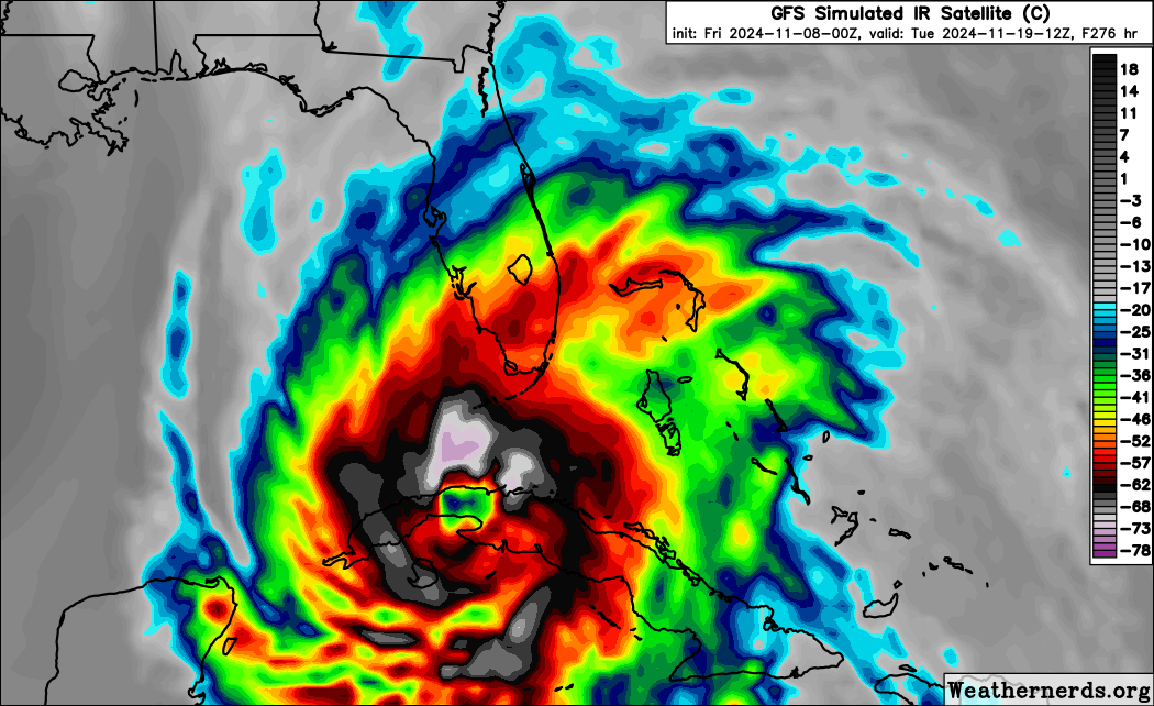
Happy thanksgiving from the gfs..

Image

Image
1 likes   

User avatar
chaser1
S2K Supporter
S2K Supporter
Posts: 5406
Age: 64
Joined: Sat Oct 15, 2005 5:59 pm
Location: Longwood, Fl

Re: 2024 Global Model Runs Discussion (Out thru day 16)

#2479 Postby chaser1 » Fri Nov 08, 2024 2:30 am

Welcome to a SPECIAL EDITION of the GFS Happy Hour extravaganza :ggreen:
One guess for the absolute safest place to be on November 20, 2024 :wink:
0 likes   
Andy D

(For official information, please refer to the NHC and NWS products.)

User avatar
SFLcane
S2K Supporter
S2K Supporter
Posts: 10162
Age: 47
Joined: Sat Jun 05, 2010 1:44 pm
Location: Lake Worth Florida

Re: 2024 Global Model Runs Discussion (Out thru day 16)

#2480 Postby SFLcane » Fri Nov 08, 2024 6:07 am

chaser1 wrote:Welcome to a SPECIAL EDITION of the GFS Happy Hour extravaganza :ggreen:
One guess for the absolute safest place to be on November 20, 2024 :wink:


06z gfs again but stronger into SFL with a major into Cuba before that.
0 likes   


Return to “Talkin' Tropics”

Who is online

Users browsing this forum: Blown Away and 101 guests