

WPAC: TORAJI - Post-Tropical
Moderator: S2k Moderators
Re: WPAC: TORAJI - Tropical Storm
0 likes
ヤンデレ女が寝取られるているのを見たい!!!
ECMWF ensemble NWPAC plots: https://ecmwfensnwpac.imgbb.com/
Multimodel NWPAC plots: https://multimodelnwpac.imgbb.com/
GFS Ensemble NWPAC plots (16 & 35 day forecast): https://gefsnwpac.imgbb.com/
Plots updated automatically
ECMWF ensemble NWPAC plots: https://ecmwfensnwpac.imgbb.com/
Multimodel NWPAC plots: https://multimodelnwpac.imgbb.com/
GFS Ensemble NWPAC plots (16 & 35 day forecast): https://gefsnwpac.imgbb.com/
Plots updated automatically

Re: WPAC: TORAJI - Tropical Storm
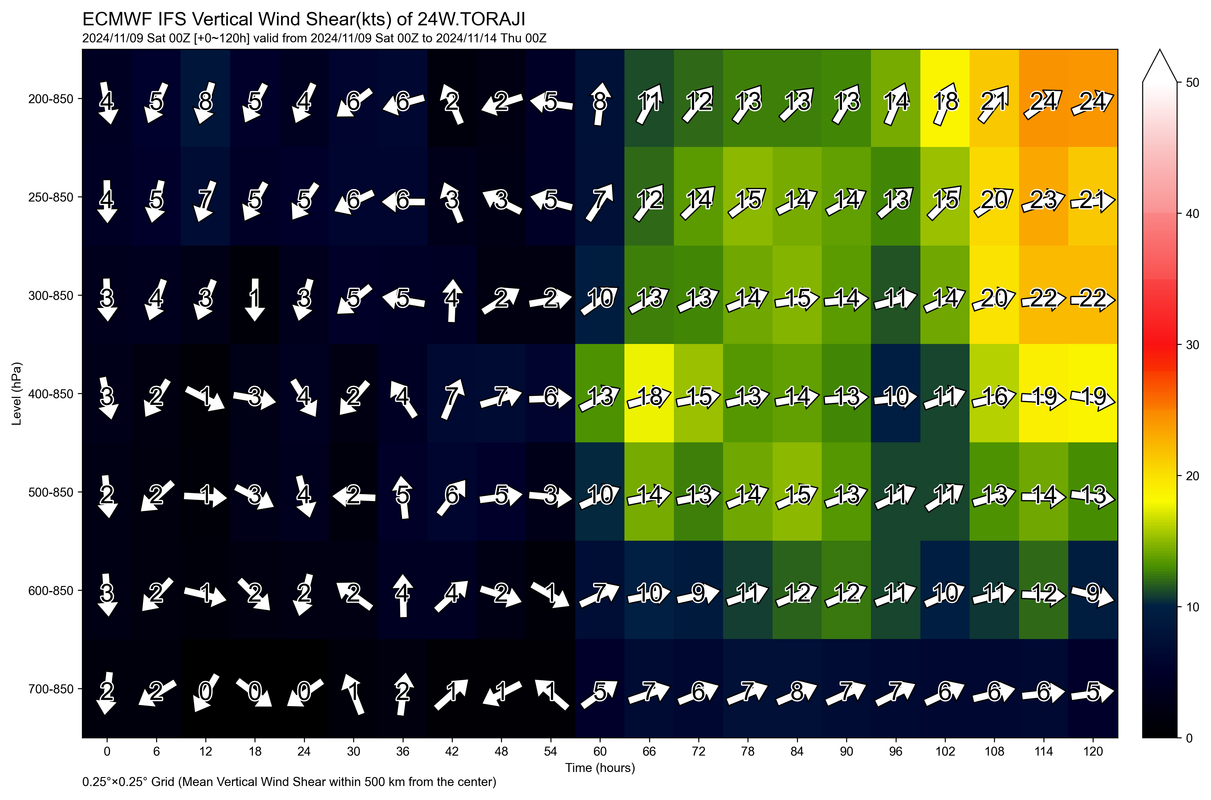
The Vertical Wind Shear will stay low before the landful, maybe a new cat-5 Typhoon is coming.
0 likes
Re: WPAC: TORAJI - Tropical Storm
EPS 00Z

0 likes
ヤンデレ女が寝取られるているのを見たい!!!
ECMWF ensemble NWPAC plots: https://ecmwfensnwpac.imgbb.com/
Multimodel NWPAC plots: https://multimodelnwpac.imgbb.com/
GFS Ensemble NWPAC plots (16 & 35 day forecast): https://gefsnwpac.imgbb.com/
Plots updated automatically
ECMWF ensemble NWPAC plots: https://ecmwfensnwpac.imgbb.com/
Multimodel NWPAC plots: https://multimodelnwpac.imgbb.com/
GFS Ensemble NWPAC plots (16 & 35 day forecast): https://gefsnwpac.imgbb.com/
Plots updated automatically
-
mrbagyo

- Category 5

- Posts: 3985
- Age: 33
- Joined: Thu Apr 12, 2012 9:18 am
- Location: 14.13N 120.98E
- Contact:
Re: WPAC: TORAJI - Tropical Storm
Models are still modest on intensity but I think this has the potential to really bomb into Super typhoon status,
0 likes
The posts in this forum are NOT official forecast and should not be used as such. They are just the opinion of the poster and may or may not be backed by sound meteorological data. They are NOT endorsed by any professional institution or storm2k.org. For official information, please refer to RSMC, NHC and NWS products.
-
dexterlabio
- Category 5
- Posts: 3517
- Joined: Sat Oct 24, 2009 11:50 pm
Re: WPAC: TORAJI - Tropical Storm
Time for the models and agencies that use them to wake up
0 likes
Personal Forecast Disclaimer:
The posts in this forum are NOT official forecast and should not be used as such. They are just the opinion of the poster and may or may not be backed by sound meteorological data. They are NOT endorsed by any professional institution or storm2k.org. For official information, please refer to the NHC and NWS products.
The posts in this forum are NOT official forecast and should not be used as such. They are just the opinion of the poster and may or may not be backed by sound meteorological data. They are NOT endorsed by any professional institution or storm2k.org. For official information, please refer to the NHC and NWS products.
-
doomhaMwx

- Category 5
- Posts: 2492
- Age: 27
- Joined: Tue Apr 18, 2017 4:01 am
- Location: Baguio/Benguet, Philippines
- Contact:
Re: WPAC: TORAJI - Tropical Storm
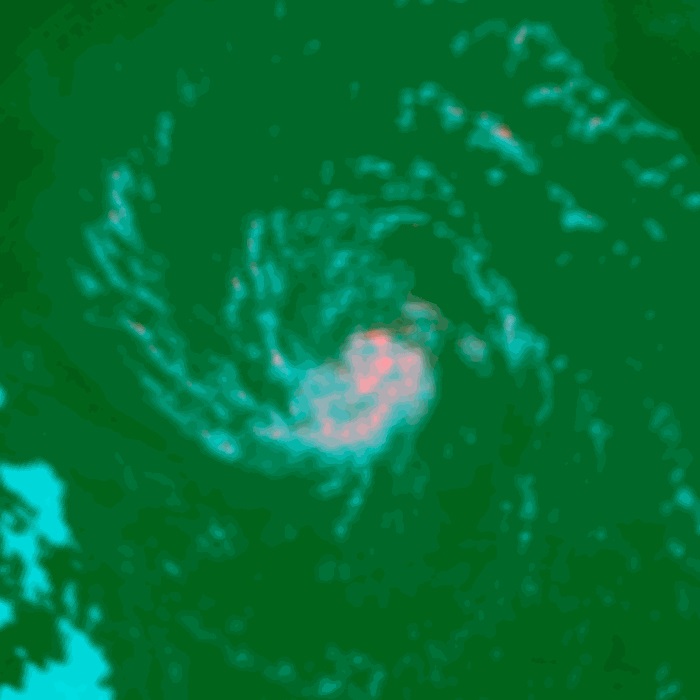
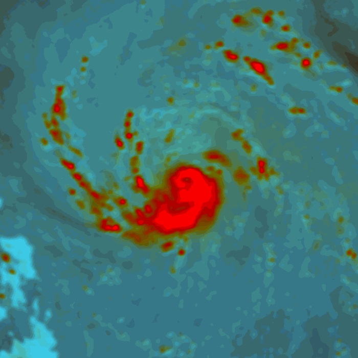
The rate at this is organizing/intensifying right now is crazy. SSMIS microwave scans taken just ~2 hours apart:

0 likes
-
dexterlabio
- Category 5
- Posts: 3517
- Joined: Sat Oct 24, 2009 11:50 pm
Re: WPAC: TORAJI - Tropical Storm
Medium range forecasts kinda dropped the ball two times in a row, first with Yinxing and now this.
0 likes
Personal Forecast Disclaimer:
The posts in this forum are NOT official forecast and should not be used as such. They are just the opinion of the poster and may or may not be backed by sound meteorological data. They are NOT endorsed by any professional institution or storm2k.org. For official information, please refer to the NHC and NWS products.
The posts in this forum are NOT official forecast and should not be used as such. They are just the opinion of the poster and may or may not be backed by sound meteorological data. They are NOT endorsed by any professional institution or storm2k.org. For official information, please refer to the NHC and NWS products.
Re: WPAC: TORAJI - Tropical Storm
Up to 50 kts
Rev to 55
26W TORAJI 241109 1200 14.6N 130.1E WPAC 50 992
Rev to 55
26W TORAJI 241109 1200 14.7N 130.3E WPAC 55 990
Last edited by Hayabusa on Sat Nov 09, 2024 9:30 am, edited 1 time in total.
0 likes
ヤンデレ女が寝取られるているのを見たい!!!
ECMWF ensemble NWPAC plots: https://ecmwfensnwpac.imgbb.com/
Multimodel NWPAC plots: https://multimodelnwpac.imgbb.com/
GFS Ensemble NWPAC plots (16 & 35 day forecast): https://gefsnwpac.imgbb.com/
Plots updated automatically
ECMWF ensemble NWPAC plots: https://ecmwfensnwpac.imgbb.com/
Multimodel NWPAC plots: https://multimodelnwpac.imgbb.com/
GFS Ensemble NWPAC plots (16 & 35 day forecast): https://gefsnwpac.imgbb.com/
Plots updated automatically
-
mrbagyo
- Category 5
- Posts: 3985
- Age: 33
- Joined: Thu Apr 12, 2012 9:18 am
- Location: 14.13N 120.98E
- Contact:
Re: WPAC: TORAJI - Tropical Storm

0 likes
The posts in this forum are NOT official forecast and should not be used as such. They are just the opinion of the poster and may or may not be backed by sound meteorological data. They are NOT endorsed by any professional institution or storm2k.org. For official information, please refer to RSMC, NHC and NWS products.
-
xtyphooncyclonex

- Category 5
- Posts: 3898
- Age: 24
- Joined: Sat Dec 08, 2012 9:07 am
- Location: Cebu City
- Contact:
Re: WPAC: TORAJI - Tropical Storm
From 30 to 55 kts in one advisory. The ceiling could be rather high, especially with such a structure.
The country should now take Toraji seriously.
Definitely think all agencies should significantly revise their intensity forecasts upwards as it's only got 48 hours or so till landfall and folks might get caught off guard.
The country should now take Toraji seriously.
Definitely think all agencies should significantly revise their intensity forecasts upwards as it's only got 48 hours or so till landfall and folks might get caught off guard.
0 likes
REMINDER: My opinions that I, or any other NON Pro-Met in this forum, are unofficial. Please do not take my opinions as an official forecast and warning. I am NOT a meteorologist. Following my forecasts blindly may lead to false alarm, danger and risk if official forecasts from agencies are ignored.
Re: WPAC: TORAJI - Tropical Storm
Landfall intensity has been upped

0 likes
ヤンデレ女が寝取られるているのを見たい!!!
ECMWF ensemble NWPAC plots: https://ecmwfensnwpac.imgbb.com/
Multimodel NWPAC plots: https://multimodelnwpac.imgbb.com/
GFS Ensemble NWPAC plots (16 & 35 day forecast): https://gefsnwpac.imgbb.com/
Plots updated automatically
ECMWF ensemble NWPAC plots: https://ecmwfensnwpac.imgbb.com/
Multimodel NWPAC plots: https://multimodelnwpac.imgbb.com/
GFS Ensemble NWPAC plots (16 & 35 day forecast): https://gefsnwpac.imgbb.com/
Plots updated automatically
-
ElectricStorm

- Category 5
- Posts: 5150
- Age: 25
- Joined: Tue Aug 13, 2019 11:23 pm
- Location: Norman, OK
Re: WPAC: TORAJI - Tropical Storm
This one concerns me quite a bit. Think this will become the next super typhoon before landfall. Unfortunately looks like it could be the same areas affected by Yinxing. And on top of that 94W and/or Man-yi behind it could be dangerous as well
0 likes
B.S Meteorology, University of Oklahoma '25
Please refer to the NHC, NWS, or SPC for official information.
Please refer to the NHC, NWS, or SPC for official information.
-
Hurricane2022

- Category 5
- Posts: 2088
- Joined: Tue Aug 23, 2022 11:38 pm
- Location: Araçatuba, Brazil
Re: WPAC: TORAJI - Tropical Storm
26W TORAJI 241110 0000 15.1N 126.9E WPAC 60 980
HELLLLL


0 likes
Sorry for the bad English sometimes...!
For reliable and detailed information for any meteorological phenomenon, please consult the National Hurricane Center, Joint Typhoon Warning Center , or your local Meteo Center.
--------
ECCE OMNIA NOVA FACIAM (Ap 21,5).
For reliable and detailed information for any meteorological phenomenon, please consult the National Hurricane Center, Joint Typhoon Warning Center , or your local Meteo Center.
--------
ECCE OMNIA NOVA FACIAM (Ap 21,5).
Re: WPAC: TORAJI - Severe Tropical Storm
HFSA 18Z makes this a cat 4 before landfall

0 likes
ヤンデレ女が寝取られるているのを見たい!!!
ECMWF ensemble NWPAC plots: https://ecmwfensnwpac.imgbb.com/
Multimodel NWPAC plots: https://multimodelnwpac.imgbb.com/
GFS Ensemble NWPAC plots (16 & 35 day forecast): https://gefsnwpac.imgbb.com/
Plots updated automatically
ECMWF ensemble NWPAC plots: https://ecmwfensnwpac.imgbb.com/
Multimodel NWPAC plots: https://multimodelnwpac.imgbb.com/
GFS Ensemble NWPAC plots (16 & 35 day forecast): https://gefsnwpac.imgbb.com/
Plots updated automatically
-
mrbagyo
- Category 5
- Posts: 3985
- Age: 33
- Joined: Thu Apr 12, 2012 9:18 am
- Location: 14.13N 120.98E
- Contact:
Re: WPAC: TORAJI - Severe Tropical Storm
26W TORAJI 241110 0600 15.2N 125.3E WPAC 65 980
0 likes
The posts in this forum are NOT official forecast and should not be used as such. They are just the opinion of the poster and may or may not be backed by sound meteorological data. They are NOT endorsed by any professional institution or storm2k.org. For official information, please refer to RSMC, NHC and NWS products.
-
mrbagyo
- Category 5
- Posts: 3985
- Age: 33
- Joined: Thu Apr 12, 2012 9:18 am
- Location: 14.13N 120.98E
- Contact:
Re: WPAC: TORAJI - Severe Tropical Storm
26W TORAJI 241110 1200 15.6N 124.4E WPAC 75 979
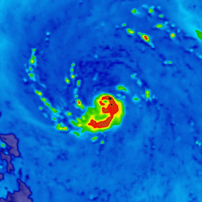
CDO is rotating more vigorously now as seen on IR loop.
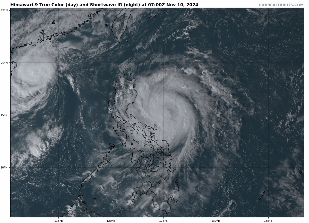
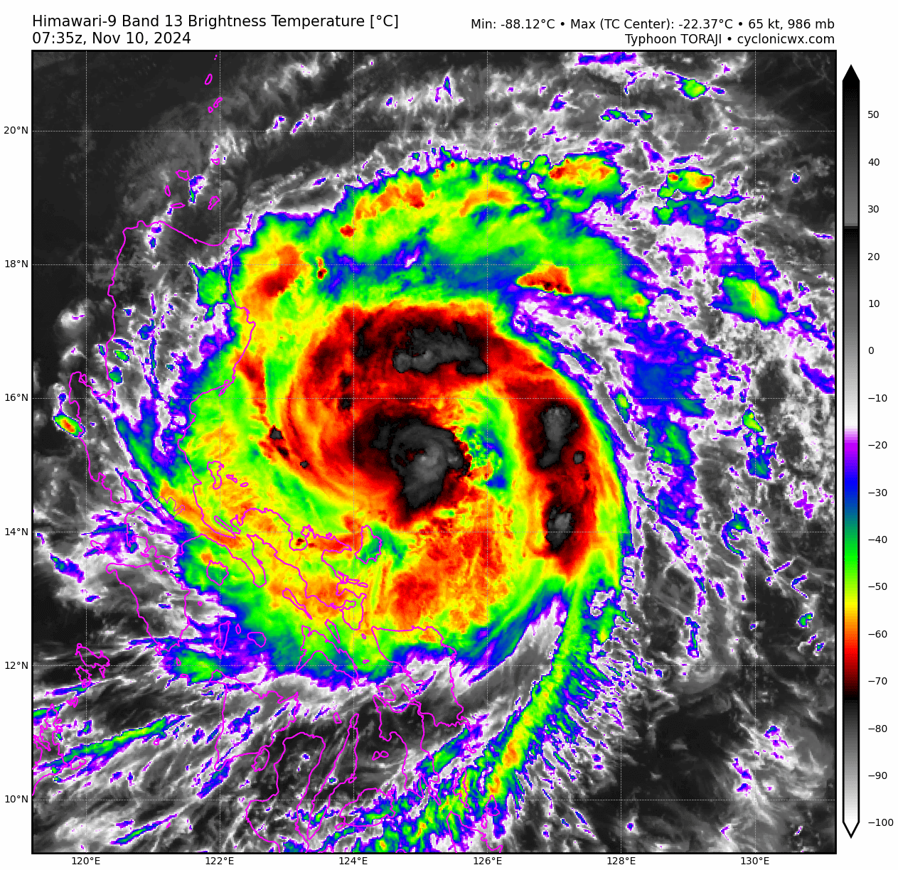
CDO is rotating more vigorously now as seen on IR loop.
1 likes
The posts in this forum are NOT official forecast and should not be used as such. They are just the opinion of the poster and may or may not be backed by sound meteorological data. They are NOT endorsed by any professional institution or storm2k.org. For official information, please refer to RSMC, NHC and NWS products.
Re: WPAC: TORAJI - Typhoon
JMA upgraded to Typhoon at 15Z
T2423(Toraji)
Issued at 2024/11/10 15:50 UTC
Analysis at 11/10 15 UTC
Grade TY
Scale -
Intensity -
Center position N15°35′ (15.6°)
E123°40′ (123.7°)
Direction and speed of movement WNW 20 km/h (11 kt)
Central pressure 980 hPa
Maximum sustained wind speed near center 35 m/s (65 kt)
Maximum wind gust speed 50 m/s (95 kt)
Radius of 50-kt wind area 110 km (60 NM)
Radius of 30-kt wind area 280 km (150 NM)
0 likes
ヤンデレ女が寝取られるているのを見たい!!!
ECMWF ensemble NWPAC plots: https://ecmwfensnwpac.imgbb.com/
Multimodel NWPAC plots: https://multimodelnwpac.imgbb.com/
GFS Ensemble NWPAC plots (16 & 35 day forecast): https://gefsnwpac.imgbb.com/
Plots updated automatically
ECMWF ensemble NWPAC plots: https://ecmwfensnwpac.imgbb.com/
Multimodel NWPAC plots: https://multimodelnwpac.imgbb.com/
GFS Ensemble NWPAC plots (16 & 35 day forecast): https://gefsnwpac.imgbb.com/
Plots updated automatically
-
doomhaMwx
- Category 5
- Posts: 2492
- Age: 27
- Joined: Tue Apr 18, 2017 4:01 am
- Location: Baguio/Benguet, Philippines
- Contact:
Re: WPAC: TORAJI - Typhoon
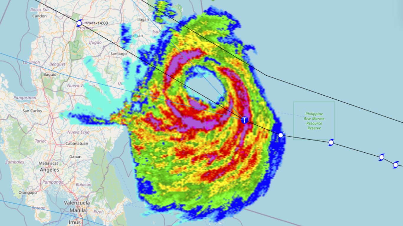
Appears to have undergone some sort of EWRC and is now sporting quite a huge (~50km) eye on radar! Fortunately, the system is quickly running out of time over water.
1 likes
-
doomhaMwx
- Category 5
- Posts: 2492
- Age: 27
- Joined: Tue Apr 18, 2017 4:01 am
- Location: Baguio/Benguet, Philippines
- Contact:
Re: WPAC: TORAJI - Tropical Storm
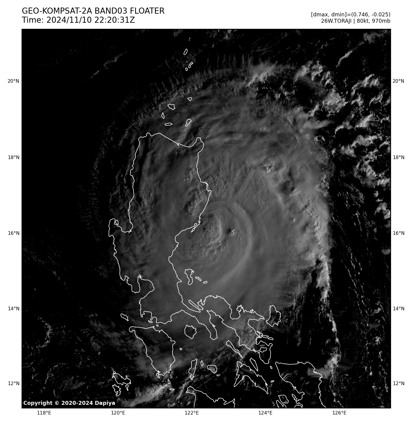
https://x.com/arielrojasPH/status/1855783010211352816
PAGASA's AWS in Dilasag, Aurora recorded a min SLP of 978.76 mb at 00:10Z in the edge of the eye/eyewall. Central pressure is likely between JTWC and JMA's estimates (970 and 980 mb, respectively).
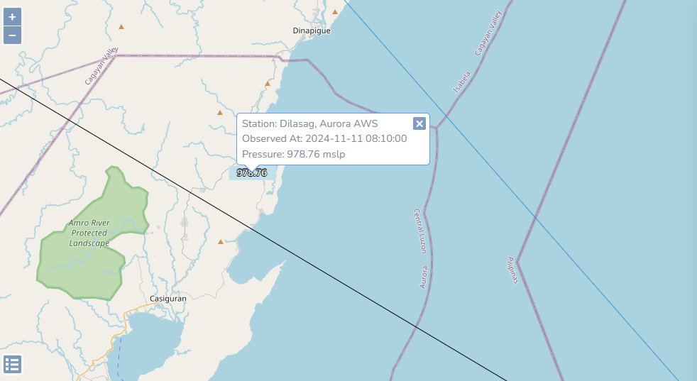
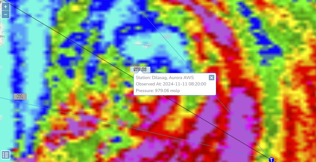
PAGASA's AWS in Dilasag, Aurora recorded a min SLP of 978.76 mb at 00:10Z in the edge of the eye/eyewall. Central pressure is likely between JTWC and JMA's estimates (970 and 980 mb, respectively).
0 likes
Who is online
Users browsing this forum: No registered users and 75 guests