Potential development over the Western Caribbean Sea (Is Invest 99L)

This is the general tropical discussion area. Anyone can take their shot at predicting a storms path.

Moderator: S2k Moderators

Forum rules

The posts in this forum are NOT official forecasts and should not be used as such. They are just the opinion of the poster and may or may not be backed by sound meteorological data. They are NOT endorsed by any professional institution or STORM2K. For official information, please refer to products from the National Hurricane Center and National Weather Service.

Help Support Storm2K
Message
Author
User avatar
Steve
S2K Supporter
S2K Supporter
Posts: 9620
Joined: Sat Apr 05, 2003 11:41 pm
Location: Not a state-caster

Re: Potential development over the Western Caribbean Sea (20/60)

#81 Postby Steve » Tue Nov 12, 2024 12:41 am

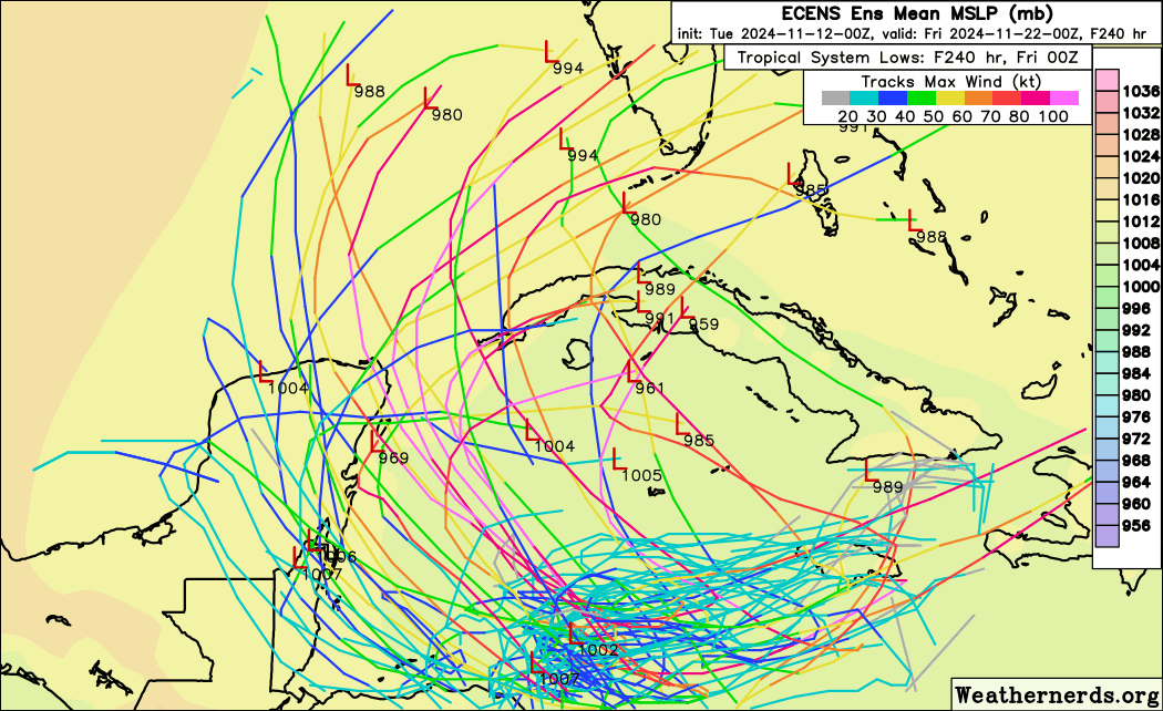
SouthFLTropics wrote:This is so surreal... If it wasn't for other model support I'd think the GFS is just trolling us at this point. But ICON, CMC, and Euro are all onboard as well. If it's going to form and be bad girl, at least Jefferson Starship wrote the perfect song for it many years ago... Sara, Sara, storms are brewin in your eyes.


They’re taking the MJO into account. Bias corrected EC and Australian and then the Climate model (CFS) have Phase 3 around the 20th/21st. CFS has been most bullish for weeks but I don’t much follow it. Hammy is the one who does. However, if these are correct 10 days out, look out SW FL.
1 likes   

caneseddy
Category 5
Category 5
Posts: 1172
Joined: Fri Sep 03, 2004 9:31 pm
Location: Plantation, FL

Re: Potential development over the Western Caribbean Sea (20/60)

#82 Postby caneseddy » Tue Nov 12, 2024 12:52 am

Canadian into Tampa Bay as a high end TS
1 likes   

caneseddy
Category 5
Category 5
Posts: 1172
Joined: Fri Sep 03, 2004 9:31 pm
Location: Plantation, FL

Re: Potential development over the Western Caribbean Sea (20/60)

#83 Postby caneseddy » Tue Nov 12, 2024 1:18 am

00z Euro bombs out at 928 in the Yucatán Channel and then swings ENE into Cuba and then heads east over Cuba
Last edited by caneseddy on Tue Nov 12, 2024 1:59 am, edited 1 time in total.
1 likes   

MarioProtVI
Category 4
Category 4
Posts: 935
Age: 24
Joined: Sun Sep 29, 2019 7:33 pm
Location: New Jersey

Re: Potential development over the Western Caribbean Sea (20/60)

#84 Postby MarioProtVI » Tue Nov 12, 2024 1:37 am

When the GFS and Euro both have sub-935, the ceiling is very high, and this could end up doing what Iota tried to do but “officially” couldn’t. 00z EPS gonna be wild.
2 likes   

User avatar
chaser1
S2K Supporter
S2K Supporter
Posts: 5464
Age: 64
Joined: Sat Oct 15, 2005 5:59 pm
Location: Longwood, Fl

Re: Potential development over the Western Caribbean Sea (20/60)

#85 Postby chaser1 » Tue Nov 12, 2024 2:14 am

Sara could seriously be bad Juju for Florida or Cuba. After the region has seen hurricanes, tornadoes, and major earthquakes.....what's next, an asteroid?
2 likes   
Andy D

(For official information, please refer to the NHC and NWS products.)

User avatar
GCANE
S2K Supporter
S2K Supporter
Posts: 11496
Joined: Mon Oct 22, 2007 8:03 am

Re: Potential development over the Western Caribbean Sea (20/60)

#86 Postby GCANE » Tue Nov 12, 2024 2:34 am

A very warm Loop Current and a very cold upper troposphere.
A deadly combination.
1 likes   

User avatar
FireRat
Category 5
Category 5
Posts: 1246
Age: 38
Joined: Sun Sep 26, 2010 11:38 pm
Location: North Carolina

Re: Potential development over the Western Caribbean Sea (20/60)

#87 Postby FireRat » Tue Nov 12, 2024 3:58 am

Imagine that y'all, a legit hurricane threat for South Florida in Late November, just days before the season ends!!
Unreal, and quite fitting for 2024. :double:
0 likes   
Georges '98, Irene '99, Frances '04, Jeanne '04, Katrina '05, Wilma '05, Gustav '08, Isaac '12, Matthew '16, Florence '18, Michael '18, Ian '22

User avatar
kevin
Category 5
Category 5
Posts: 2586
Age: 26
Joined: Wed Aug 28, 2019 4:35 am

Re: Potential development over the Western Caribbean Sea (30/70)

#88 Postby kevin » Tue Nov 12, 2024 4:30 am

Ensembles are very aggressive with this system. 45 out of 51 (88%) 00z Euro members develop the system within 48 hours. 26 out of 31 (84%) 00z GEFS members do the same within 48 hours. As such I'd personally put development chances closer to 70/90 or 80/90 than the current 20/60. The most recent 06z ICON already has a 1006 mb system within 48 hours and 991 mb within 120 hours. If today's 06z and 12z GFS and Euro ensembles are similar I also expect NHC to start an invest and to up the chances to something around 50/80 or 60/80.

Euro

Also that one member landfalling north of TB as a MH would probably result in a bigger surge than they had with Milton. Extremely unlikely, but crazy that it's even a remote possibility in mid-November.
Image

GEFS

Image
1 likes   

User avatar
kevin
Category 5
Category 5
Posts: 2586
Age: 26
Joined: Wed Aug 28, 2019 4:35 am

Re: Potential development over the Western Caribbean Sea (30/70)

#89 Postby kevin » Tue Nov 12, 2024 5:08 am

06z GFS isn't backing down :eek:.
Edit: peaks at 929 mb later in the run and remains around the 929 - 932 mb pressure for at least 24 hours (run isn't finished yet).

Image
1 likes   

jlauderdal
S2K Supporter
S2K Supporter
Posts: 7182
Joined: Wed May 19, 2004 5:46 am
Location: NE Fort Lauderdale
Contact:

Re: Potential development over the Western Caribbean Sea (20/60)

#90 Postby jlauderdal » Tue Nov 12, 2024 5:26 am

GCANE wrote:A very warm Loop Current and a very cold upper troposphere.
A deadly combination.

Shear looking minimal, very far out but no help there knocking this thing back.
1 likes   

User avatar
kevin
Category 5
Category 5
Posts: 2586
Age: 26
Joined: Wed Aug 28, 2019 4:35 am

Re: Potential development over the Western Caribbean Sea (30/70)

#91 Postby kevin » Tue Nov 12, 2024 5:31 am

06z GFS, Bradenton/Sarasota landfall because why not...

Image
1 likes   

User avatar
cycloneye
Admin
Admin
Posts: 145277
Age: 68
Joined: Thu Oct 10, 2002 10:54 am
Location: San Juan, Puerto Rico

Re: Potential development over the Western Caribbean Sea (30/70)

#92 Postby cycloneye » Tue Nov 12, 2024 5:32 am

kevin wrote:06z GFS isn't backing down :eek:.
Edit: peaks at 929 mb later in the run and remains around the 929 - 932 mb pressure for at least 24 hours (run isn't finished yet).

https://i.imgur.com/rA8klhY.png


This run is to Tampa, Sarasota.

Image
1 likes   
Visit the Caribbean-Central America Weather Thread where you can find at first post web cams,radars
and observations from Caribbean basin members Click Here

User avatar
SFLcane
S2K Supporter
S2K Supporter
Posts: 10163
Age: 47
Joined: Sat Jun 05, 2010 1:44 pm
Location: Lake Worth Florida

Re: Potential development over the Western Caribbean Sea (30/70)

#93 Postby SFLcane » Tue Nov 12, 2024 5:43 am

cycloneye wrote:
kevin wrote:06z GFS isn't backing down :eek:.
Edit: peaks at 929 mb later in the run and remains around the 929 - 932 mb pressure for at least 24 hours (run isn't finished yet).

https://i.imgur.com/rA8klhY.png


This run is to Tampa, Sarasota.

https://i.imgur.com/cuZLMXl.png


Looks south of Tampa…
0 likes   

User avatar
SFLcane
S2K Supporter
S2K Supporter
Posts: 10163
Age: 47
Joined: Sat Jun 05, 2010 1:44 pm
Location: Lake Worth Florida

Re: Potential development over the Western Caribbean Sea (30/70)

#94 Postby SFLcane » Tue Nov 12, 2024 5:44 am

What is this madness?.. :double:

Image
1 likes   

xironman
S2K Supporter
S2K Supporter
Posts: 2522
Joined: Sun Jun 10, 2007 4:53 pm
Location: NoVA

Re: Potential development over the Western Caribbean Sea (30/70)

#95 Postby xironman » Tue Nov 12, 2024 5:48 am

Only caught half of it, but a legit spin going on.

Image
2 likes   

caneman
Category 5
Category 5
Posts: 1447
Joined: Fri Sep 05, 2014 5:44 am
Location: Clearwater Beach, Fl

Re: Potential development over the Western Caribbean Sea (30/70)

#96 Postby caneman » Tue Nov 12, 2024 6:00 am

SFLcane wrote:
cycloneye wrote:
kevin wrote:06z GFS isn't backing down :eek:.
Edit: peaks at 929 mb later in the run and remains around the 929 - 932 mb pressure for at least 24 hours (run isn't finished yet).

https://i.imgur.com/rA8klhY.png


This run is to Tampa, Sarasota.

https://i.imgur.com/cuZLMXl.png


Looks south of Tampa…


Wind wise, the effects would be nearly the same North of Sarasota in Tampa plus if it it's moving NORTHEAST. Milton proved that.
1 likes   

User avatar
SFLcane
S2K Supporter
S2K Supporter
Posts: 10163
Age: 47
Joined: Sat Jun 05, 2010 1:44 pm
Location: Lake Worth Florida

Re: Potential development over the Western Caribbean Sea (30/70)

#97 Postby SFLcane » Tue Nov 12, 2024 6:14 am

:eek:

Image
4 likes   

User avatar
aspen
Category 5
Category 5
Posts: 8818
Joined: Sat Oct 12, 2019 7:10 pm
Location: Connecticut, USA

Re: Potential development over the Western Caribbean Sea (30/70)

#98 Postby aspen » Tue Nov 12, 2024 6:49 am

The entire model suite now shows slightly early development and an eastward turn right before it runs into Central America. Things can still change, but if that holds, we’re probably getting yet another November major.

Starting to think Sara might be another one-and-done name this season…
2 likes   
Irene '11 Sandy '12 Hermine '16 5/15/2018 Derecho Fay '20 Isaias '20 Elsa '21 Henri '21 Ida '21

I am only a meteorology enthusiast who knows a decent amount about tropical cyclones. Look to the professional mets, the NHC, or your local weather office for the best information.

User avatar
Hypercane_Kyle
Category 5
Category 5
Posts: 3352
Joined: Sat Mar 07, 2015 7:58 pm
Location: Cape Canaveral, FL

Re: Potential development over the Western Caribbean Sea (30/70)

#99 Postby Hypercane_Kyle » Tue Nov 12, 2024 6:51 am

Bad sign when the Euro, CMC, GFS, ICON, and somehow even the Korean model all are in agreement here.
1 likes   
My posts are my own personal opinion, defer to the National Hurricane Center (NHC) and other NOAA products for decision making during hurricane season.

User avatar
kevin
Category 5
Category 5
Posts: 2586
Age: 26
Joined: Wed Aug 28, 2019 4:35 am

Re: Potential development over the Western Caribbean Sea (30/70)

#100 Postby kevin » Tue Nov 12, 2024 6:52 am

06z is the most aggressive GFS ensemble yet with many US impacts. 10 out of the 31 members (32%) either landfall in the US or are about to do so in this image.

Image
1 likes   


Return to “Talkin' Tropics”

Who is online

Users browsing this forum: AnnularCane, Hurricaneman and 37 guests