ATL: SARA - Models
Moderator: S2k Moderators
-
CFLHurricane

- Category 1

- Posts: 350
- Joined: Thu Mar 27, 2014 5:56 pm
- Location: Floriduh
Re: ATL: INVEST 99L - Models
[imgur]https://imgur.com/a/Jvdvc0A[/imgur]
Yeah, sure, why not
(12z GFS bisects Florida peninsula with a major hurricane from Sarasota to Vero Beach)
Yeah, sure, why not
(12z GFS bisects Florida peninsula with a major hurricane from Sarasota to Vero Beach)
Last edited by CFLHurricane on Tue Nov 12, 2024 2:02 pm, edited 3 times in total.
1 likes
I'm not a meteorologist, but I did stay at a motel 8.

Re: ATL: INVEST 99L - Models
Now that we have an invest, hopefully the hurricane models will come to an agreement.
If it does end up in the Gulf, I doubt it will make as far north as some of the models have shown but who knows. This season climatology has been thrown out.
If it does end up in the Gulf, I doubt it will make as far north as some of the models have shown but who knows. This season climatology has been thrown out.
1 likes

Re: ATL: INVEST 99L - Models
First SHIPS forecast is bullish and could have significant effects for Honduras/Nicaragua in the shorter term. The MPI for this thing is crazy for November.

2 likes

Re: ATL: INVEST 99L - Models
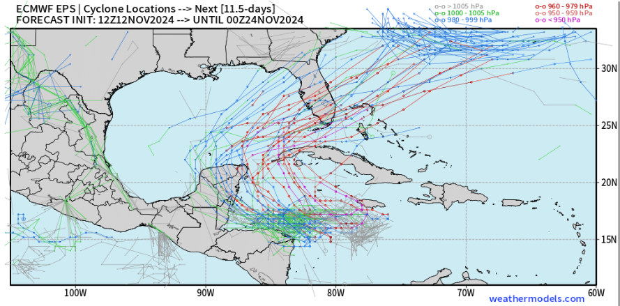
12z GFS intensity if you use Dvorak to convert from pressure to wind speed.
Total ACE from 99L = 32.7
Timestamp (hr) / Pressure (mb) / Wind speed (kt)
36 / 1005 / 35 - TS
42 / 1003 / 40
48 / 1002 / 40
54 / 998 / 45
60 / 993 / 55
66 / 990 / 60
72 / 984 / 65 - C1
78 / 972 / 85 - C2
84 / 968 / 90
90 / 962 / 100 - C3
96 / 957 / 105
102 / 952 / 110
108 / 950 / 115
114 / 946 / 115 - C4
120 / 942 / 120
126 / 938 / 125
132 / 937 / 125
138 / 943 / 120
144 / 944 / 120
150 / 942 / 120
156 / 943 / 120
162 / 943 / 120
168 / 942 / 120
174 / 946 / 115
180 / 948 / 115
186 / 952 / 110
192 / 956 / 105
198 / 959 / 105 - Florida landfall
204 / 965 / 95
210 / 966 / 95
216 / 974 / 85
222 / 977 / 80
228 / 985 / 65
234 / 990 / 60
240 / 995 / 55 - post-tropical
2 likes
Re: ATL: INVEST 99L - Models
18z should, if I understand correctly, also contain the hurricane models for 99L. Very curious what they will show.
1 likes


-
CrazyC83
- Professional-Met

- Posts: 34316
- Joined: Tue Mar 07, 2006 11:57 pm
- Location: Deep South, for the first time!
Re: ATL: INVEST 99L - Models
As we have learned over the years, you can't trust climatology.
One other thing: if the trough is faster and Sara a little stronger, it could easily result in a Sandy-like epic phasing of the two systems and Sara could be drawn up the east coast. It's plausible at this point.
One other thing: if the trough is faster and Sara a little stronger, it could easily result in a Sandy-like epic phasing of the two systems and Sara could be drawn up the east coast. It's plausible at this point.
4 likes

-
CrazyC83
- Professional-Met
- Posts: 34316
- Joined: Tue Mar 07, 2006 11:57 pm
- Location: Deep South, for the first time!
Re: ATL: INVEST 99L - Models
Those northern lines are a separate extratropical low, which I've seen some models bring down to about 970 mb. (Could it get low enough to take on subtropical characteristics?)
1 likes
-
WaveBreaking

- Category 2

- Posts: 727
- Joined: Sun Jun 30, 2024 11:33 am
- Location: US
Re: ATL: INVEST 99L - Models
CrazyC83 wrote:As we have learned over the years, you can't trust climatology.
One other thing: if the trough is faster and Sara a little stronger, it could easily result in a Sandy-like epic phasing of the two systems and Sara could be drawn up the east coast. It's plausible at this point.
A powerful Mid-November hurricane that phases with a trough and becomes a hybrid/nor'easter-type storm while causing extensive damage to the East Coast would be a fitting end to this season.
2 likes
I am NOT a professional meteorologist, so take all of my posts with a grain of salt. My opinions are mine and mine alone.
-
gatorcane

- S2K Supporter

- Posts: 23708
- Age: 48
- Joined: Sun Mar 13, 2005 3:54 pm
- Location: Boca Raton, FL
Re: ATL: INVEST 99L - Models
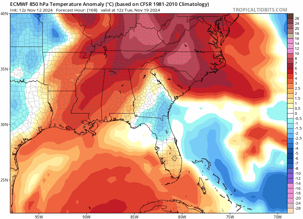
Wow the Euro brings a very cold airmass (much below normal for a change) down into the SE US and Florida in the wake of the storm. If there are power outages, at least it won't be hot, the cold would be the issue.
1 likes
-
jlauderdal
- S2K Supporter
- Posts: 7240
- Joined: Wed May 19, 2004 5:46 am
- Location: NE Fort Lauderdale
- Contact:
Re: ATL: INVEST 99L - Models
gatorcane wrote:Wow the Euro brings a very cold airmass (much below normal for a change) down into the SE US and Florida in the wake of the storm. If there are power outages, at least it won't be hot, the cold would be the issue.
https://i.postimg.cc/GhX0TzBv/ec-fast-T850a-seus-fh168-240.gif
Wilma redux with the chilly post hurricane weather. Total darkness with crisp weather was an oddity after its passage.
5 likes
-
SouthFLTropics

- Category 5

- Posts: 4258
- Age: 50
- Joined: Thu Aug 14, 2003 8:04 am
- Location: Port St. Lucie, Florida
Re: ATL: INVEST 99L - Models
That potential cold air spilling in behind it is almost identical to Wilma. I remember having to go out and do inspections on the roadways right after Wilma passed. The winds were still blowing between 30 and 40 miles per hour. When I walked out of the front door of my house I almost froze. I had to go back in and get a jacket. When this thing takes off to the Northeast it is going to be racing. Any possible weakening of the storm on approach to the SW Florida coast would probably be offset by the front enhancing the effects. Just like Wilma, 19 years later.
4 likes
Fourth Generation Florida Native
Personal Storm History: David 79, Andrew 92, Erin 95, Floyd 99, Irene 99, Frances 04, Jeanne 04, Wilma 05, Matthew 16, Irma 17, Ian 22, Nicole 22, Milton 24
Personal Storm History: David 79, Andrew 92, Erin 95, Floyd 99, Irene 99, Frances 04, Jeanne 04, Wilma 05, Matthew 16, Irma 17, Ian 22, Nicole 22, Milton 24
Re: ATL: INVEST 99L - Models
gatorcane wrote:Wow the Euro brings a very cold airmass (much below normal for a change) down into the SE US and Florida in the wake of the storm. If there are power outages, at least it won't be hot, the cold would be the issue.
https://i.postimg.cc/GhX0TzBv/ec-fast-T850a-seus-fh168-240.gif
How cold is that for SFL?
0 likes
Andrew (1992), Irene (1999), Frances (2004), Katrina (2005), Wilma (2005), Fay (2008), Irma (2017), Eta (2020), Ian (2022)
-
mcheer23

- Professional-Met
- Posts: 441
- Age: 32
- Joined: Sun Jun 24, 2012 8:24 pm
- Location: Sugar Land, Texas
Re: ATL: INVEST 99L - Models
Nuno wrote:gatorcane wrote:Wow the Euro brings a very cold airmass (much below normal for a change) down into the SE US and Florida in the wake of the storm. If there are power outages, at least it won't be hot, the cold would be the issue.
https://i.postimg.cc/GhX0TzBv/ec-fast-T850a-seus-fh168-240.gif
How cold is that for SFL?
Low 50's
2 likes

Re: ATL: INVEST 99L - Models
Nuno wrote:gatorcane wrote:Wow the Euro brings a very cold airmass (much below normal for a change) down into the SE US and Florida in the wake of the storm. If there are power outages, at least it won't be hot, the cold would be the issue.
https://i.postimg.cc/GhX0TzBv/ec-fast-T850a-seus-fh168-240.gif
How cold is that for SFL?
I'd guess mid 70's for highs, low 60's for lows for the Metro areas. Few degrees cooler a bit more inland. Keep in mind that the EURO is a bit faster with the front then the GFS
0 likes
Andy D
(For official information, please refer to the NHC and NWS products.)
(For official information, please refer to the NHC and NWS products.)
-
tolakram
- Admin

- Posts: 20186
- Age: 62
- Joined: Sun Aug 27, 2006 8:23 pm
- Location: Florence, KY (name is Mark)
Re: ATL: INVEST 99L - Models
CFLHurricane wrote:https://imgur.com/a/Jvdvc0A
Yeah, sure, why not
(12z GFS bisects Florida peninsula with a major hurricane from Sarasota to Vero Beach)
For animated GIFS you have to use the BBCODE links, otherwise it's a video and can't be embedded here. Only GIFS have this issue with IMGUR
1 likes
M a r k
- - - - -
Join us in chat: Storm2K Chatroom Invite. Android and IOS apps also available.
The posts in this forum are NOT official forecasts and should not be used as such. Posts are NOT endorsed by any professional institution or STORM2K.org. For official information and forecasts, please refer to NHC and NWS products.
Re: ATL: INVEST 99L - Models
18z Icon only goes out to Sunday but has a slowly intensifying hurricane just meandering off the north coast of Honduras a la Mitch
1 likes
Re: ATL: INVEST 99L - Models
18z slightly more north than 12z and narrowly avoids landfall. As such, it is stronger over the next 120 hours than 12z. Beyond the 120 hour runtime of 18z this scenario would probably still result in a Beliza/Mexico landfall.

0 likes
Who is online
Users browsing this forum: No registered users and 25 guests