Have a hard time believing this will get to the Tampa/Sarasota latitude where it would be sheared apart, seems like if were to hit FL it would be more of a SWFL impact a la Wilma.
I could be wrong of course but hope not (nor do I hope it hits SWFL).
ATL: SARA - Remnants - Discussion
Moderator: S2k Moderators
-
HurricaneBelle

- S2K Supporter

- Posts: 1209
- Joined: Sun Aug 27, 2006 6:12 pm
- Location: Clearwater, FL
Re: ATL: INVEST 99L - Discussion
3 likes
-
Miami Storm Tracker

- Category 4

- Posts: 916
- Age: 68
- Joined: Sun Jun 13, 2010 10:12 pm
- Location: Key Largo, Fla.
- Contact:
Re: ATL: INVEST 99L - Discussion
Unfortunately I feel the same way, thought I had gotten through this season good compared to the folks north and west of me.
0 likes
-
galaxy401

- Category 5

- Posts: 2446
- Age: 30
- Joined: Sat Aug 25, 2012 9:04 pm
- Location: Casa Grande, Arizona
Re: ATL: INVEST 99L - Discussion
I mean it is October 12th right now so these type of storms need to be watched.
(This season has been a month behind on everything since September. There will probably be a storm in December at this rate.)
(This season has been a month behind on everything since September. There will probably be a storm in December at this rate.)
2 likes
Got my eyes on moving right into Hurricane Alley: Florida.
-
AutoPenalti
- Category 5
- Posts: 4091
- Age: 29
- Joined: Mon Aug 17, 2015 4:16 pm
- Location: Ft. Lauderdale, Florida
Re: ATL: INVEST 99L - Discussion
galaxy401 wrote:I mean it is October 12th right now so these type of storms need to be watched.
(This season has been a month behind on everything since September. There will probably be a storm in December at this rate.)
You're a month behind.
4 likes
The posts in this forum are NOT official forecasts and should not be used as such. They are just the opinion of the poster and may or may not be backed by sound meteorological data. They are NOT endorsed by any professional institution or STORM2K. For official information, please refer to products from the NHC and NWS.
Model Runs Cheat Sheet:
GFS (5:30 AM/PM, 11:30 AM/PM)
HWRF, GFDL, UKMET, NAVGEM (6:30-8:00 AM/PM, 12:30-2:00 AM/PM)
ECMWF (1:45 AM/PM)
TCVN is a weighted averaged
-
Weathertracker96
- Tropical Storm

- Posts: 150
- Joined: Mon Oct 16, 2023 3:41 pm
Re: ATL: INVEST 99L - Discussion
What day does everyone think we will know for sure where this may go and what this will do?
0 likes

Re: ATL: INVEST 99L - Discussion
An excellently put together discussion on potential Sarah.
Certainly does not make us in South Florida feel very good about the possible Wilma 2.0
0 likes
Personal Forecast Disclaimer:
My posts are just my opinion and are most likely not backed by sound meteorological data. They are NOT endorsed by any professional institution or storm2k.org. For official information, please refer to the NHC and NWS products.
Bottom line is that I am just expressing my opinion!!!
My posts are just my opinion and are most likely not backed by sound meteorological data. They are NOT endorsed by any professional institution or storm2k.org. For official information, please refer to the NHC and NWS products.
Bottom line is that I am just expressing my opinion!!!
-
SFLcane

- S2K Supporter
- Posts: 10281
- Age: 48
- Joined: Sat Jun 05, 2010 1:44 pm
- Location: Lake Worth Florida
Re: ATL: INVEST 99L - Discussion
fci wrote:
An excellently put together discussion on potential Sarah.
Certainly does not make us in South Florida feel very good about the possible Wilma 2.0
Hey fci, just noticed your in Lake Worth! i am in lake worth also about 5 min from wellington
0 likes
-
galaxy401
- Category 5
- Posts: 2446
- Age: 30
- Joined: Sat Aug 25, 2012 9:04 pm
- Location: Casa Grande, Arizona
Re: ATL: INVEST 99L - Discussion
AutoPenalti wrote:galaxy401 wrote:I mean it is October 12th right now so these type of storms need to be watched.
(This season has been a month behind on everything since September. There will probably be a storm in December at this rate.)
You're a month behind.
Yeah that's the joke. Season is running a month behind throughout.
10 likes
Got my eyes on moving right into Hurricane Alley: Florida.


Re: ATL: INVEST 99L - Discussion
Matching fairly well with the 18z GFS simulated IR. The GFS may be onto something.
0 likes
Irene '11 Sandy '12 Hermine '16 5/15/2018 Derecho Fay '20 Isaias '20 Elsa '21 Henri '21 Ida '21
I am only a meteorology enthusiast who knows a decent amount about tropical cyclones. Look to the professional mets, the NHC, or your local weather office for the best information.
I am only a meteorology enthusiast who knows a decent amount about tropical cyclones. Look to the professional mets, the NHC, or your local weather office for the best information.

Re: ATL: INVEST 99L - Discussion
Im surprised there isnt a 5pm update from NHC regarding this system, but I suppose not much has changed.
0 likes
All posts by Dean_175 are NOT official forecasts and should not be used as such. They are just the opinion of the poster and may or may not be backed by sound meteorological data. They are NOT endorsed by any professional institution or storm2k.org. For official information, please refer to the NHC and NWS products.

Re: ATL: INVEST 99L - Discussion
Dean_175 wrote:Im surprised there isnt a 5pm update from NHC regarding this system, but I suppose not much has changed.
Advisory times are actually 4am/pm and 10am/pm Eastern now, since we've switched to standard time but NHC's advisory cycles remain the same in terms of UTC. Regardless, TWO updates for systems that are not TCs or PTCs only come at 1am/pm and 7am/pm EST (2am/pm and 8am/pm EDT), so still an hour to go.
1 likes
TC naming lists: retirements and intensity
Most aggressive Advisory #1's in North Atlantic (cr. kevin for starting the list)
Most aggressive Advisory #1's in North Atlantic (cr. kevin for starting the list)
-
Hypercane_Kyle

- Category 5
- Posts: 3465
- Joined: Sat Mar 07, 2015 7:58 pm
- Location: Cape Canaveral, FL
Re: ATL: INVEST 99L - Discussion
Dean_175 wrote:Im surprised there isnt a 5pm update from NHC regarding this system, but I suppose not much has changed.
It's not a PTC or TC so there wouldn't be a 5pm update; only 7am, 1pm, 7pm, and 1am.
0 likes
My posts are my own personal opinion, defer to the National Hurricane Center (NHC) and other NOAA products for decision making during hurricane season.
Re: ATL: INVEST 99L - Discussion
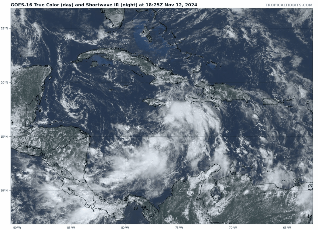
Central and Western Caribbean Sea (AL99):
Showers and thunderstorms over the central Caribbean Sea have become
more organized in associated with a broad area of low pressure.
Environmental conditions appear conducive for development, and a
tropical depression is likely to form within the next couple of days
while the system moves slowly westward into the western Caribbean
Sea. Afterward, further development is likely while the disturbance
meanders over the western Caribbean Sea through the weekend. The
system is forecast begin moving slowly northwestward by early next
week. Interests across the western and northwestern Caribbean Sea
should monitor the progress of this system. Regardless of
development, heavy rains are expected over Jamaica and portions of
Haiti during the next day or so.
* Formation chance through 48 hours...high...70 percent.
* Formation chance through 7 days...high...90 percent.
2 likes
Re: ATL: INVEST 99L - Discussion

2 likes
TC naming lists: retirements and intensity
Most aggressive Advisory #1's in North Atlantic (cr. kevin for starting the list)
Most aggressive Advisory #1's in North Atlantic (cr. kevin for starting the list)
-
SconnieCane
- Category 5
- Posts: 1013
- Joined: Thu Aug 02, 2018 5:29 pm
- Location: Madison, WI
Re: ATL: INVEST 99L - Discussion
Strong consensus this is going to be the system that pushes us into hyperactive territory, and quite solidly at that.
0 likes

Re: ATL: INVEST 99L - Discussion
Some nearby pressure measurements in the Caribbean are finding sea-level pressures of 1006 - 1008 mb. Difficult to say whether this is just the background pressure or whether it's influenced by 99L in any way. Either way, I think this is more similar to the situation GFS is coming with since the Euro and ICON still have this above or around 1010 mb for the next 24 hours. Furthermore, while no measurements seem to be present at or very close to 99L, nearby ships/buoys have measured gusts up to 46 kmh (25 kt) and 10-minute wind speeds of 35 kmh (20 kt) within the last 6 hours.
Last edited by kevin on Tue Nov 12, 2024 6:42 pm, edited 1 time in total.
1 likes
-
cycloneye

- Admin

- Posts: 149261
- Age: 69
- Joined: Thu Oct 10, 2002 10:54 am
- Location: San Juan, Puerto Rico
Re: ATL: INVEST 99L - Discussion
Any recent ASCAT to see how is the structure?
0 likes
Visit the Caribbean-Central America Weather Thread where you can find at first post web cams,radars
and observations from Caribbean basin members Click Here
and observations from Caribbean basin members Click Here
-
WaveBreaking

- Category 2

- Posts: 717
- Joined: Sun Jun 30, 2024 11:33 am
- Location: US
Re: ATL: INVEST 99L - Discussion
kevin wrote:Some nearby pressure measurements in the Caribbean are finding sea-level pressures of 1006 - 1008 mb. Difficult to say whether this is just the background pressure or whether it's influenced by 99L in any way.
It’s mainly background pressure per the Euro and GFS analyses.


0 likes
I am NOT a professional meteorologist, so take all of my posts with a grain of salt. My opinions are mine and mine alone.
Who is online
Users browsing this forum: No registered users and 24 guests