ATL: SARA - Models
Moderator: S2k Moderators


Re: ATL: INVEST 99L - Models
0z GFS has the system peaking at 922 hPa at 114 hours, with a fairly long & nearly stationary Category 4/5 peak, then weakening as it moves north-northwest into the Yucatan - but still making landfall there as a (likely) major hurricane, around 955 hPa. Not backing away from this pattern of stronger solutions, it seems.
2 likes


Re: ATL: INVEST 99L - Models
0Z gfs has it slamming into the yucatan which should weaken it pretty good. Could be the start of more westward adjustments similar to the euro imo. Btw cmc has massive land interaction with just leftovers entering the gulf
0 likes

Re: ATL: INVEST 99L - Models
Euro landfalls in Yucatán just south of Tulum as a major hurricane and exits north coast of Yucatán into the Gulf as a Cat 2…goes over the flat part of the Peninsula it looks like
Second landfall just north of Fort Myers as a Cat 2/borderline Cat 3 and exits near Vero Beach
Second landfall just north of Fort Myers as a Cat 2/borderline Cat 3 and exits near Vero Beach
3 likes

ATL: INVEST 99L - Discussion
2 likes


Re: ATL: INVEST 99L - Models
HWRF already makes this TS Sara within 6 - 12 hours. HMON takes 42 hours, HAFS-A 24 hours and HAFS-B 36 hours. HWRF also is the only of the 06z hurricane models to completely avoid a CA landfall in the short-term. As such, I'd say a stronger Sara in the upcoming 24 hours will also result in a stronger WCar peak due to it tracking more east.
5 likes
Re: ATL: INVEST 99L - Models
6z GFS goes thru Florida Straits barely missing the Keys as a Cat 2
0 likes
-
cycloneye

- Admin

- Posts: 149672
- Age: 69
- Joined: Thu Oct 10, 2002 10:54 am
- Location: San Juan, Puerto Rico
Re: ATL: INVEST 99L - Models
06z euro ensembles at 144 hours.

1 likes
Visit the Caribbean-Central America Weather Thread where you can find at first post web cams,radars
and observations from Caribbean basin members Click Here
and observations from Caribbean basin members Click Here
-
chris_fit

- Category 5

- Posts: 3261
- Age: 43
- Joined: Wed Sep 10, 2003 11:58 pm
- Location: Tampa Bay Area, FL
Re: ATL: INVEST 99L - Models
caneseddy wrote:6z GFS goes thru Florida Straits barely missing the Keys as a Cat 2
Indeed. Most 06z GFS Ens however are a bit north of the OP run.

1 likes
-
DESTRUCTION5

- Category 5
- Posts: 4430
- Age: 44
- Joined: Wed Sep 03, 2003 11:25 am
- Location: Stuart, FL
Re: ATL: INVEST 99L - Models
I also noticed most of the Ensembles both gfs and Euro avoid the Yuc vs the operationals. And nearly none go south of Fl like the 06 gfs advertises. Something to watch.
Last edited by DESTRUCTION5 on Wed Nov 13, 2024 7:57 am, edited 1 time in total.
1 likes
GATOR NATION IS E V E R Y W H E R E !
-
jlauderdal
- S2K Supporter

- Posts: 7240
- Joined: Wed May 19, 2004 5:46 am
- Location: NE Fort Lauderdale
- Contact:
Re: ATL: INVEST 99L - Models
DESTRUCTION5 wrote:I also noticed most of the Ensembles both gfs and Euro avoid the Yuc vs the operationals. And nearly non go south of Fl like the 06 gfs advertises. Something to watch.
Ensembles should get far more weight at this point.
0 likes
-
WaveBreaking

- Category 2

- Posts: 727
- Joined: Sun Jun 30, 2024 11:33 am
- Location: US
Re: ATL: INVEST 99L - Models
EPS members are further west than the GEFS ones, but they still mostly show future Sara missing Central America and heading N. Some pretty powerful members in both runs too.


1 likes
I am NOT a professional meteorologist, so take all of my posts with a grain of salt. My opinions are mine and mine alone.
-
Blown Away

- S2K Supporter
- Posts: 10253
- Joined: Wed May 26, 2004 6:17 am
Re: ATL: INVEST 99L - Models
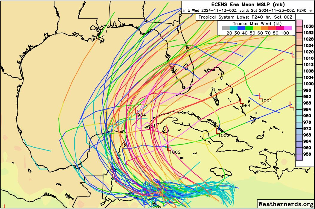
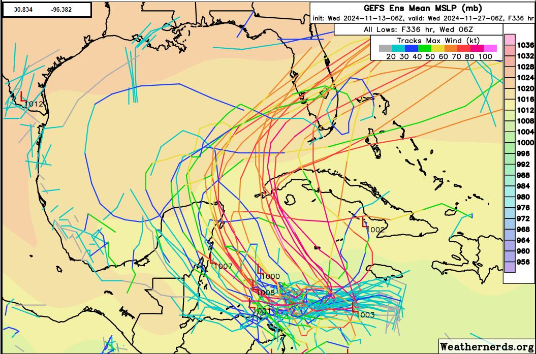
00z ECENS
06z GEFS
Last edited by Blown Away on Wed Nov 13, 2024 10:03 am, edited 1 time in total.
1 likes
Hurricane Eye Experience: David 79, Irene 99, Frances 04, Jeanne 04, Wilma 05… Hurricane Brush Experience: Andrew 92, Erin 95, Floyd 99, Matthew 16, Irma 17, Ian 22, Nicole 22…

-
SouthFLTropics

- Category 5
- Posts: 4258
- Age: 50
- Joined: Thu Aug 14, 2003 8:04 am
- Location: Port St. Lucie, Florida
Re: ATL: INVEST 99L - Models
Looking at the models I think the setup here is pretty clear. However, I'd say that there are still two options on the table that can best be described by the two analogs I can think of. It's either going to be Mitch (buried in Central America) or it's going to be Wilma (North and then Northeast). If I'm placing odds, I'd go with 70/30 in favor of the Wilma scenario. I'm going with brief landfall on the Yucatan followed by a Chokoloskee landfall as a Cat 2 and a rapid crossing across the Florida peninsula with an exit into the Atlantic at Delray Beach.
3 likes
Fourth Generation Florida Native
Personal Storm History: David 79, Andrew 92, Erin 95, Floyd 99, Irene 99, Frances 04, Jeanne 04, Wilma 05, Matthew 16, Irma 17, Ian 22, Nicole 22, Milton 24
Personal Storm History: David 79, Andrew 92, Erin 95, Floyd 99, Irene 99, Frances 04, Jeanne 04, Wilma 05, Matthew 16, Irma 17, Ian 22, Nicole 22, Milton 24

-
tolakram
- Admin
- Posts: 20186
- Age: 62
- Joined: Sun Aug 27, 2006 8:23 pm
- Location: Florence, KY (name is Mark)
Re: ATL: INVEST 99L - Models
ICON seems to have a third solution. Missing frames at the end but appears to be a low end tropical storm crossing Florida well north.

0 likes
M a r k
- - - - -
Join us in chat: Storm2K Chatroom Invite. Android and IOS apps also available.
The posts in this forum are NOT official forecasts and should not be used as such. Posts are NOT endorsed by any professional institution or STORM2K.org. For official information and forecasts, please refer to NHC and NWS products.
-
SconnieCane
- Category 5
- Posts: 1013
- Joined: Thu Aug 02, 2018 5:29 pm
- Location: Madison, WI
Re: ATL: INVEST 99L - Models
tolakram wrote:ICON seems to have a third solution. Missing frames at the end but appears to be a low end tropical storm crossing Florida well north.
https://i.imgur.com/4ir3sUQ.gif
Gets buried in Belize/Yucatan much longer and over rougher terrain than according to the other models.
0 likes
Who is online
Users browsing this forum: No registered users and 109 guests