WPAC: MAN-YI - Post-Tropical

Moderator: S2k Moderators

Message
Author
User avatar
mrbagyo
Category 5
Category 5
Posts: 3711
Age: 32
Joined: Thu Apr 12, 2012 9:18 am
Location: 14.13N 120.98E
Contact:

Re: WPAC: MAN-YI - Typhoon

#61 Postby mrbagyo » Thu Nov 14, 2024 6:57 pm

Every slight deviation in movement will affect location of the landfall.

Pepito looks like the real deal, no way this doesn't reach Cat 5 given the favourable environment it is in.

Image
0 likes   
The posts in this forum are NOT official forecast and should not be used as such. They are just the opinion of the poster and may or may not be backed by sound meteorological data. They are NOT endorsed by any professional institution or storm2k.org. For official information, please refer to RSMC, NHC and NWS products.

User avatar
xtyphooncyclonex
Category 5
Category 5
Posts: 3857
Age: 23
Joined: Sat Dec 08, 2012 9:07 am
Location: Cebu City
Contact:

Re: WPAC: MAN-YI - Typhoon

#62 Postby xtyphooncyclonex » Thu Nov 14, 2024 9:38 pm

Yea... he has that look

Image
4 likes   
REMINDER: My opinions that I, or any other NON Pro-Met in this forum, are unofficial. Please do not take my opinions as an official forecast and warning. I am NOT a meteorologist. Following my forecasts blindly may lead to false alarm, danger and risk if official forecasts from agencies are ignored.

underthwx
Category 5
Category 5
Posts: 2351
Joined: Sat Jul 30, 2011 2:14 pm
Location: Brazoria County Texas

Re: WPAC: MAN-YI - Severe Tropical Storm

#63 Postby underthwx » Thu Nov 14, 2024 11:35 pm

Hayabusa wrote:
underthwx wrote:
Hayabusa wrote:The EC-AIFS is tracking this close to or over the capital region.

Basically nearer to Metro Manila?

Yes, traditional models might be playing catch up on track...

Thanks Hayabusa.
0 likes   

User avatar
mrbagyo
Category 5
Category 5
Posts: 3711
Age: 32
Joined: Thu Apr 12, 2012 9:18 am
Location: 14.13N 120.98E
Contact:

Re: WPAC: MAN-YI - Typhoon

#64 Postby mrbagyo » Thu Nov 14, 2024 11:52 pm

I expect a full CDG cloud cover later this evening

Image

Image
2 likes   
The posts in this forum are NOT official forecast and should not be used as such. They are just the opinion of the poster and may or may not be backed by sound meteorological data. They are NOT endorsed by any professional institution or storm2k.org. For official information, please refer to RSMC, NHC and NWS products.

AnmlstcBhvr
Tropical Wave
Tropical Wave
Posts: 2
Joined: Fri Nov 08, 2024 11:12 am

Re: WPAC: MAN-YI - Typhoon

#65 Postby AnmlstcBhvr » Fri Nov 15, 2024 12:36 am

xtyphooncyclonex wrote:Yea... he has that look

https://i.ibb.co/SQrMrfg/f46021c3-4a5e-438c-a3a3-ecd99dafbdf3.jpg


I was wondering how wide is its coverage, sir?
0 likes   

User avatar
mrbagyo
Category 5
Category 5
Posts: 3711
Age: 32
Joined: Thu Apr 12, 2012 9:18 am
Location: 14.13N 120.98E
Contact:

Re: WPAC: MAN-YI - Typhoon

#66 Postby mrbagyo » Fri Nov 15, 2024 3:48 am

Image
1 likes   
The posts in this forum are NOT official forecast and should not be used as such. They are just the opinion of the poster and may or may not be backed by sound meteorological data. They are NOT endorsed by any professional institution or storm2k.org. For official information, please refer to RSMC, NHC and NWS products.

User avatar
xtyphooncyclonex
Category 5
Category 5
Posts: 3857
Age: 23
Joined: Sat Dec 08, 2012 9:07 am
Location: Cebu City
Contact:

Re: WPAC: MAN-YI - Typhoon

#67 Postby xtyphooncyclonex » Fri Nov 15, 2024 7:33 am

Man-yi still has over a day left before landfall, at least if it misses Catanduanes, and it's likely to hit 100 kt in the next advisory. That said, I'd say the ceiling may be higher than JTWC's 125 kt. It's now a matter of time before we see our season's sixth super typhoon, and third super typhoon landfall in a month --- unless an EWRC comes to its way or if Catanduanes puts a halt.

Hoping Luzon's eastern seaboard is taking serious measures at the moment.
0 likes   
REMINDER: My opinions that I, or any other NON Pro-Met in this forum, are unofficial. Please do not take my opinions as an official forecast and warning. I am NOT a meteorologist. Following my forecasts blindly may lead to false alarm, danger and risk if official forecasts from agencies are ignored.

User avatar
Hayabusa
Category 5
Category 5
Posts: 4243
Joined: Sun Sep 16, 2018 1:05 pm

Re: WPAC: MAN-YI - Typhoon

#68 Postby Hayabusa » Fri Nov 15, 2024 8:02 am

It's getting there just need to clear out that ragged eye
0 likes   
ヤンデレ女が寝取られるているのを見たい!!!
ECMWF ensemble NWPAC plots: https://ecmwfensnwpac.imgbb.com/
Multimodel NWPAC plots: https://multimodelnwpac.imgbb.com/
GFS Ensemble NWPAC plots (16 & 35 day forecast): https://gefsnwpac.imgbb.com/
Plots updated automatically

User avatar
Hayabusa
Category 5
Category 5
Posts: 4243
Joined: Sun Sep 16, 2018 1:05 pm

Re: WPAC: MAN-YI - Typhoon

#69 Postby Hayabusa » Fri Nov 15, 2024 8:52 am

ADT stopped updating since 1100z
2024NOV15 093000 5.3 964.3 97.2 4.5 4.4 4.4 NO LIMIT ON FLG OFF OFF -65.71 -70.08 UNIFRM N/A 57.8 11.18 -129.88 ARCHER HIM-9 18.2
2024NOV15 100000 5.3 964.3 97.2 4.5 4.4 4.4 NO LIMIT ON FLG OFF OFF -62.81 -69.95 UNIFRM N/A 71.5 11.21 -129.77 ARCHER HIM-9 18.3
2024NOV15 104000 5.3 964.2 97.2 4.5 4.4 4.4 NO LIMIT ON FLG OFF OFF -43.81 -67.86 UNIFRM N/A 71.5 11.37 -129.59 ARCHER HIM-9 18.6
2024NOV15 110000 5.3 964.2 97.2 4.5 5.0 5.5 0.5T/hour ON OFF OFF OFF -21.65 -66.54 EYE -99 IR 71.5 11.38 -129.50 ARCHER HIM-9 18.6
Utilizing history file /home/misc/ADTV9.1/scripts/history/25W.ODT
Successfully completed listing
0 likes   
ヤンデレ女が寝取られるているのを見たい!!!
ECMWF ensemble NWPAC plots: https://ecmwfensnwpac.imgbb.com/
Multimodel NWPAC plots: https://multimodelnwpac.imgbb.com/
GFS Ensemble NWPAC plots (16 & 35 day forecast): https://gefsnwpac.imgbb.com/
Plots updated automatically

User avatar
mrbagyo
Category 5
Category 5
Posts: 3711
Age: 32
Joined: Thu Apr 12, 2012 9:18 am
Location: 14.13N 120.98E
Contact:

Re: WPAC: MAN-YI - Typhoon

#70 Postby mrbagyo » Fri Nov 15, 2024 10:07 am

12z Legaspi Sounding
Image
0 likes   
The posts in this forum are NOT official forecast and should not be used as such. They are just the opinion of the poster and may or may not be backed by sound meteorological data. They are NOT endorsed by any professional institution or storm2k.org. For official information, please refer to RSMC, NHC and NWS products.

User avatar
aspen
Category 5
Category 5
Posts: 8812
Joined: Sat Oct 12, 2019 7:10 pm
Location: Connecticut, USA

Re: WPAC: MAN-YI - Typhoon

#71 Postby aspen » Fri Nov 15, 2024 1:33 pm

It’s had a great structure since yesterday afternoon (US Eastern time), but it hasn’t been intensifying as fast as I thought it would have been. Probably a high C3 or low C4 by now. Hurricane models show the potential for some weakening in the last bit before landfall, which is good, but unfortunately it’s yet another strong typhoon landfall for the northern Philippines.
1 likes   
Irene '11 Sandy '12 Hermine '16 5/15/2018 Derecho Fay '20 Isaias '20 Elsa '21 Henri '21 Ida '21

I am only a meteorology enthusiast who knows a decent amount about tropical cyclones. Look to the professional mets, the NHC, or your local weather office for the best information.

User avatar
Hayabusa
Category 5
Category 5
Posts: 4243
Joined: Sun Sep 16, 2018 1:05 pm

Re: WPAC: MAN-YI - Typhoon

#72 Postby Hayabusa » Fri Nov 15, 2024 1:49 pm

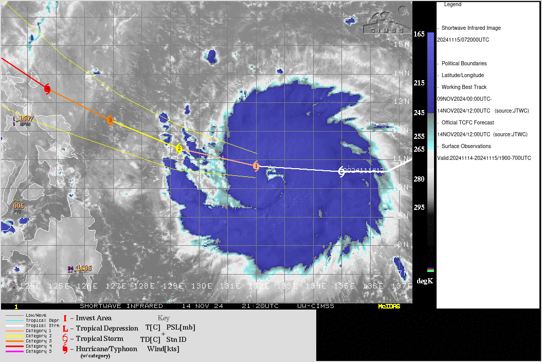
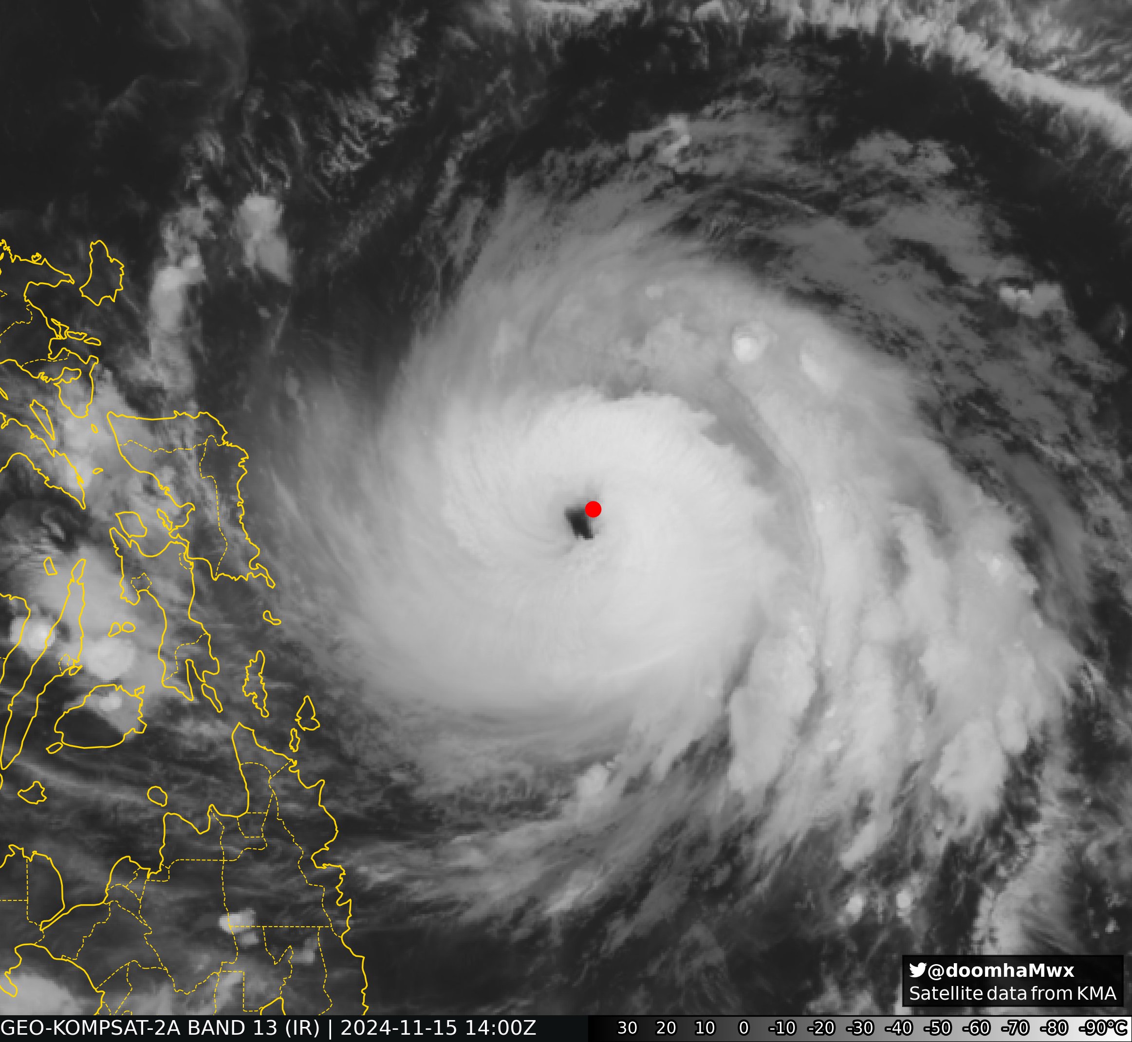
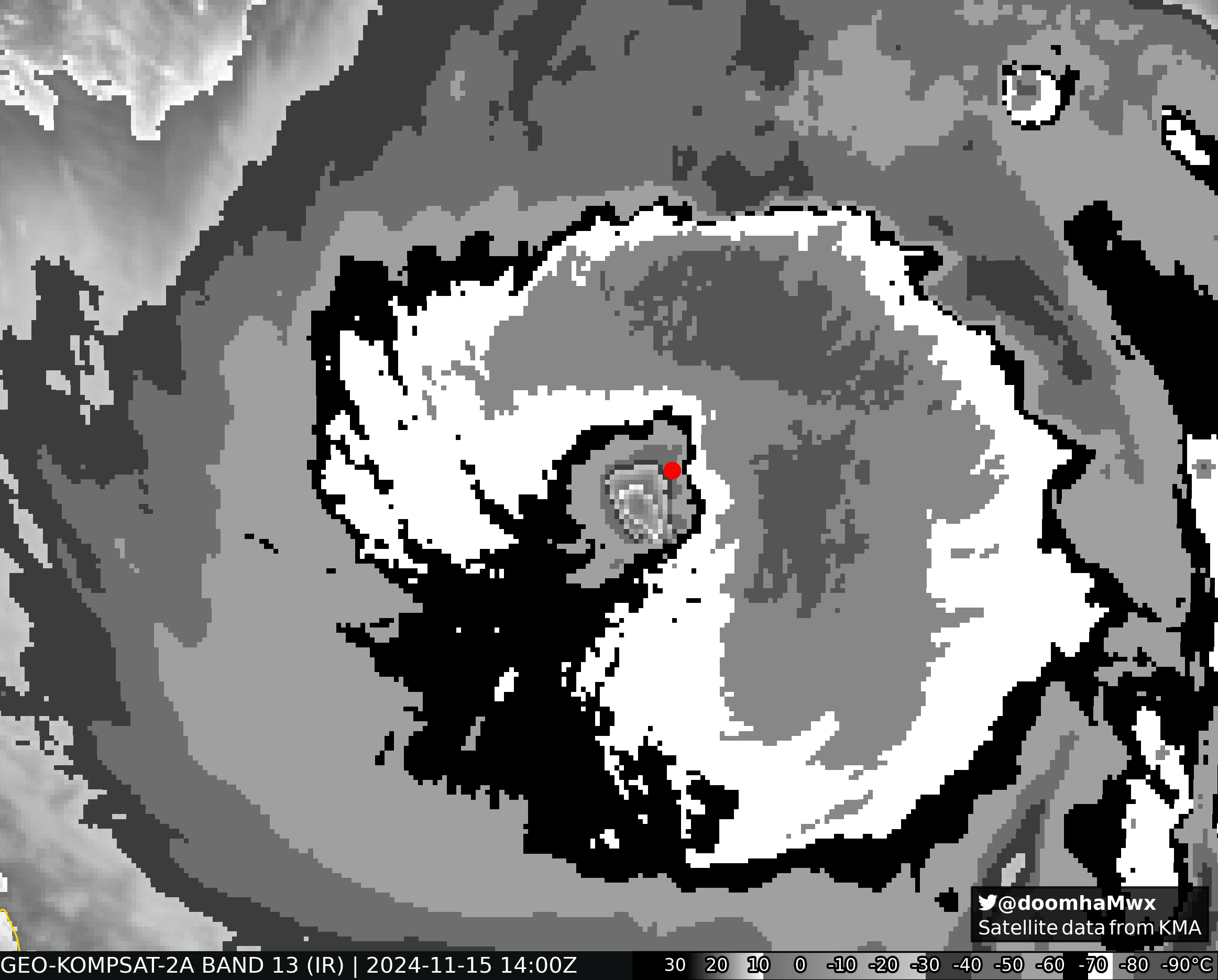
aspen wrote:It’s had a great structure since yesterday afternoon (US Eastern time), but it hasn’t been intensifying as fast as I thought it would have been. Probably a high C3 or low C4 by now. Hurricane models show the potential for some weakening in the last bit before landfall, which is good, but unfortunately it’s yet another strong typhoon landfall for the northern Philippines.

Though right now it looks like it might try again to really RI, still has 17-18 hours left if it makes landfall over Catanduanes first...
0 likes   
ヤンデレ女が寝取られるているのを見たい!!!
ECMWF ensemble NWPAC plots: https://ecmwfensnwpac.imgbb.com/
Multimodel NWPAC plots: https://multimodelnwpac.imgbb.com/
GFS Ensemble NWPAC plots (16 & 35 day forecast): https://gefsnwpac.imgbb.com/
Plots updated automatically

User avatar
Hayabusa
Category 5
Category 5
Posts: 4243
Joined: Sun Sep 16, 2018 1:05 pm

Re: WPAC: MAN-YI - Typhoon

#73 Postby Hayabusa » Fri Nov 15, 2024 2:12 pm

JTWC and JMA 18Z
25W MAN-YI 241115 1800 12.0N 127.8E WPAC 110 952

T2424(Man-yi)
Issued at 2024/11/15 19:05 UTC
Analysis at 11/15 18 UTC
Grade TY
Scale -
Intensity Very Strong
Center position N12°00′ (12.0°)
E127°50′ (127.8°)
Direction and speed of movement WNW 25 km/h (13 kt)
Central pressure 940 hPa
Maximum sustained wind speed near center 50 m/s (95 kt)
Maximum wind gust speed 70 m/s (135 kt)
Radius of 50-kt wind area 130 km (70 NM)
Radius of 30-kt wind area E390 km (210 NM)
W280 km (150 NM)
0 likes   
ヤンデレ女が寝取られるているのを見たい!!!
ECMWF ensemble NWPAC plots: https://ecmwfensnwpac.imgbb.com/
Multimodel NWPAC plots: https://multimodelnwpac.imgbb.com/
GFS Ensemble NWPAC plots (16 & 35 day forecast): https://gefsnwpac.imgbb.com/
Plots updated automatically

underthwx
Category 5
Category 5
Posts: 2351
Joined: Sat Jul 30, 2011 2:14 pm
Location: Brazoria County Texas

Re: WPAC: MAN-YI - Typhoon

#74 Postby underthwx » Fri Nov 15, 2024 3:33 pm

mrbagyo wrote:Every slight deviation in movement will affect location of the landfall.

Pepito looks like the real deal, no way this doesn't reach Cat 5 given the favourable environment it is in.

https://s11.gifyu.com/images/Sy552.gif
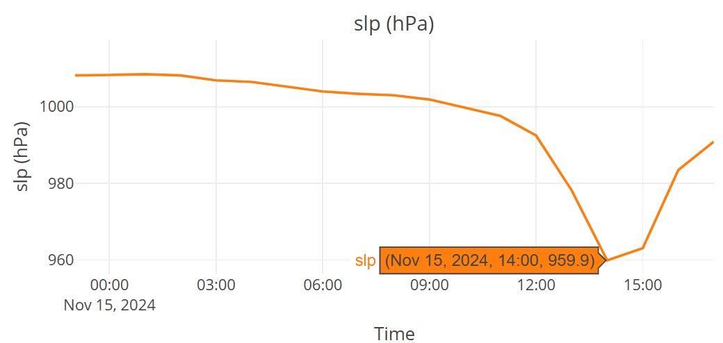
Ugh to that. I'm worried about my family big time. I have been thru the worst a cyclone can deliver, and take away, I should be there to help them manage thru this dang cyclone. Yall please forgive me if I seem biased about my concern for my people there, I'm very concerned about everyone in harms wayy. This cyclone means business, so I feel uneasy not being there to use my experience with events like Pepito. They are experienced as well with typhoons, it's a natural part of life there, living in the impact zones of the Phillipines, but I worry about everyone anyways
Thanks to Hayabusa and the crew there covering the WPAC, I am grateful to yall for information regarding this cyclone, and all the others that have threatened my people, and my many bros there. And I am aware that some of yall 2K members are in harms way as well, but yall are still on top of this emergency, for that, I respect yall, Storm 2K is fortunate to count you among its ranks. Peace yall.
Last edited by underthwx on Fri Nov 15, 2024 3:51 pm, edited 2 times in total.
0 likes   

User avatar
doomhaMwx
Category 5
Category 5
Posts: 2454
Age: 26
Joined: Tue Apr 18, 2017 4:01 am
Location: Baguio/Benguet, Philippines
Contact:

Re: WPAC: MAN-YI - Typhoon

#75 Postby doomhaMwx » Fri Nov 15, 2024 3:43 pm

Drifting buoy "5201831" in the Philippine Sea recorded an MSLP of 959.9 mb near (or inside?) the eye at 14Z.

Image
Image
Image
0 likes   

User avatar
aspen
Category 5
Category 5
Posts: 8812
Joined: Sat Oct 12, 2019 7:10 pm
Location: Connecticut, USA

Re: WPAC: MAN-YI - Typhoon

#76 Postby aspen » Fri Nov 15, 2024 3:43 pm

Hayabusa wrote:JTWC and JMA 18Z
25W MAN-YI 241115 1800 12.0N 127.8E WPAC 110 952

T2424(Man-yi)
Issued at 2024/11/15 19:05 UTC
Analysis at 11/15 18 UTC
Grade TY
Scale -
Intensity Very Strong
Center position N12°00′ (12.0°)
E127°50′ (127.8°)
Direction and speed of movement WNW 25 km/h (13 kt)
Central pressure 940 hPa
Maximum sustained wind speed near center 50 m/s (95 kt)
Maximum wind gust speed 70 m/s (135 kt)
Radius of 50-kt wind area 130 km (70 NM)
Radius of 30-kt wind area E390 km (210 NM)
W280 km (150 NM)

More JTWC lowballing. While the eye is still somewhat ragged and not fully cleared out yet, there’s no a full W ring with some CMG, so something like 120-125 kt seems more likely.
1 likes   
Irene '11 Sandy '12 Hermine '16 5/15/2018 Derecho Fay '20 Isaias '20 Elsa '21 Henri '21 Ida '21

I am only a meteorology enthusiast who knows a decent amount about tropical cyclones. Look to the professional mets, the NHC, or your local weather office for the best information.

User avatar
Hayabusa
Category 5
Category 5
Posts: 4243
Joined: Sun Sep 16, 2018 1:05 pm

Re: WPAC: MAN-YI - Typhoon

#77 Postby Hayabusa » Fri Nov 15, 2024 3:51 pm

Image
0 likes   
ヤンデレ女が寝取られるているのを見たい!!!
ECMWF ensemble NWPAC plots: https://ecmwfensnwpac.imgbb.com/
Multimodel NWPAC plots: https://multimodelnwpac.imgbb.com/
GFS Ensemble NWPAC plots (16 & 35 day forecast): https://gefsnwpac.imgbb.com/
Plots updated automatically

User avatar
Hayabusa
Category 5
Category 5
Posts: 4243
Joined: Sun Sep 16, 2018 1:05 pm

Re: WPAC: MAN-YI - Typhoon

#78 Postby Hayabusa » Fri Nov 15, 2024 4:01 pm

00z intensity will now be interesting
TPPN12 PGTW 152056

A. TYPHOON 25W (MAN-YI)

B. 15/2030Z

C. 12.27N

D. 127.32E

E. ONE/GK2A

F. T6.5/6.5/D2.5/24HRS STT: D0.5/03HRS

G. IR/EIR

H. REMARKS: 05A/PBO IRREG EYE/ANMTN. WMG EYE SURROUNDED BY W YIELDS
AN E# OF 6.0. ADDED 1.0 EYE ADJUSTMENT FOR W, TO YIELD A DT OF 7.0.
MET YIELDS A 5.5. PT YIELDS A 6.5. DBO PT.

I. ADDITIONAL POSITIONS:
15/1710Z 11.90N 128.00E AMS2


LINDGREN
0 likes   
ヤンデレ女が寝取られるているのを見たい!!!
ECMWF ensemble NWPAC plots: https://ecmwfensnwpac.imgbb.com/
Multimodel NWPAC plots: https://multimodelnwpac.imgbb.com/
GFS Ensemble NWPAC plots (16 & 35 day forecast): https://gefsnwpac.imgbb.com/
Plots updated automatically

User avatar
aspen
Category 5
Category 5
Posts: 8812
Joined: Sat Oct 12, 2019 7:10 pm
Location: Connecticut, USA

Re: WPAC: MAN-YI - Typhoon

#79 Postby aspen » Fri Nov 15, 2024 4:18 pm

Hayabusa wrote:00z intensity will now be interesting
TPPN12 PGTW 152056

A. TYPHOON 25W (MAN-YI)

B. 15/2030Z

C. 12.27N

D. 127.32E

E. ONE/GK2A

F. T6.5/6.5/D2.5/24HRS STT: D0.5/03HRS

G. IR/EIR

H. REMARKS: 05A/PBO IRREG EYE/ANMTN. WMG EYE SURROUNDED BY W YIELDS
AN E# OF 6.0. ADDED 1.0 EYE ADJUSTMENT FOR W, TO YIELD A DT OF 7.0.
MET YIELDS A 5.5. PT YIELDS A 6.5. DBO PT.

I. ADDITIONAL POSITIONS:
15/1710Z 11.90N 128.00E AMS2


LINDGREN

At the rate it’s improving, we may get T7.0 or even a T7.5 at 00z. Getting close to a thick CMG ring now. If that holds with a clear eye, it’s an easy T7.5.
0 likes   
Irene '11 Sandy '12 Hermine '16 5/15/2018 Derecho Fay '20 Isaias '20 Elsa '21 Henri '21 Ida '21

I am only a meteorology enthusiast who knows a decent amount about tropical cyclones. Look to the professional mets, the NHC, or your local weather office for the best information.

User avatar
aspen
Category 5
Category 5
Posts: 8812
Joined: Sat Oct 12, 2019 7:10 pm
Location: Connecticut, USA

Re: WPAC: MAN-YI - Typhoon

#80 Postby aspen » Fri Nov 15, 2024 5:11 pm

Positive eye temps with a full W ring. This is a Super Typhoon. May or may not be a Cat 5, winds may still be catching up with its rapid structural improvement.
1 likes   
Irene '11 Sandy '12 Hermine '16 5/15/2018 Derecho Fay '20 Isaias '20 Elsa '21 Henri '21 Ida '21

I am only a meteorology enthusiast who knows a decent amount about tropical cyclones. Look to the professional mets, the NHC, or your local weather office for the best information.


Return to “2024”

Who is online

Users browsing this forum: No registered users and 23 guests