https://weather-models.info/news/sentinel/2024Man-yi/
WPAC: MAN-YI - Post-Tropical
Moderator: S2k Moderators
- doomhaMwx
- Category 5
- Posts: 2454
- Age: 26
- Joined: Tue Apr 18, 2017 4:01 am
- Location: Baguio/Benguet, Philippines
- Contact:
Re: WPAC: MAN-YI - Typhoon
7 likes
- xtyphooncyclonex
- Category 5
- Posts: 3857
- Age: 23
- Joined: Sat Dec 08, 2012 9:07 am
- Location: Cebu City
- Contact:
Re: WPAC: MAN-YI - Typhoon
Based on recent trends, it appears that Man-yi may scrape the northern part of Catanduanes or miss it to its north because of an apparent northerly component. Impacts would be grave, nonetheless.
A miss *may* mean it could hold up stronger than forecasts, unless an EWRC takes place.
0 likes
REMINDER: My opinions that I, or any other NON Pro-Met in this forum, are unofficial. Please do not take my opinions as an official forecast and warning. I am NOT a meteorologist. Following my forecasts blindly may lead to false alarm, danger and risk if official forecasts from agencies are ignored.
- mrbagyo
- Category 5
- Posts: 3711
- Age: 32
- Joined: Thu Apr 12, 2012 9:18 am
- Location: 14.13N 120.98E
- Contact:
Re: WPAC: MAN-YI - Typhoon


1 likes
The posts in this forum are NOT official forecast and should not be used as such. They are just the opinion of the poster and may or may not be backed by sound meteorological data. They are NOT endorsed by any professional institution or storm2k.org. For official information, please refer to RSMC, NHC and NWS products.
-
- Category 5
- Posts: 3466
- Joined: Sat Oct 24, 2009 11:50 pm
Re: WPAC: MAN-YI - Typhoon
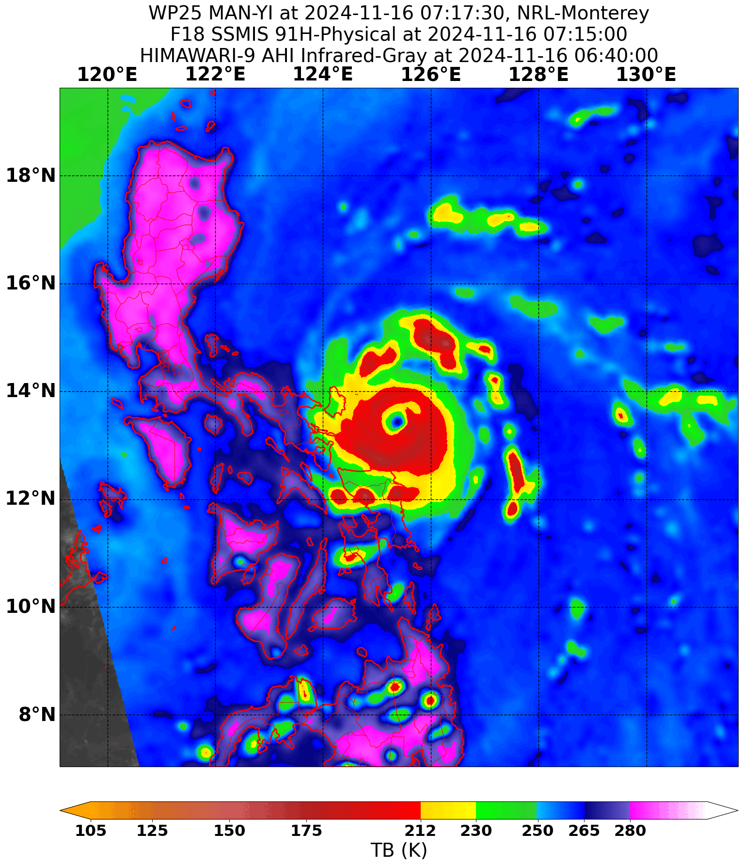
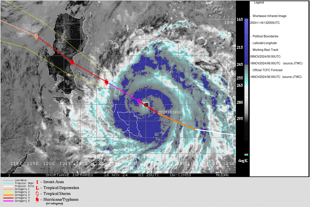
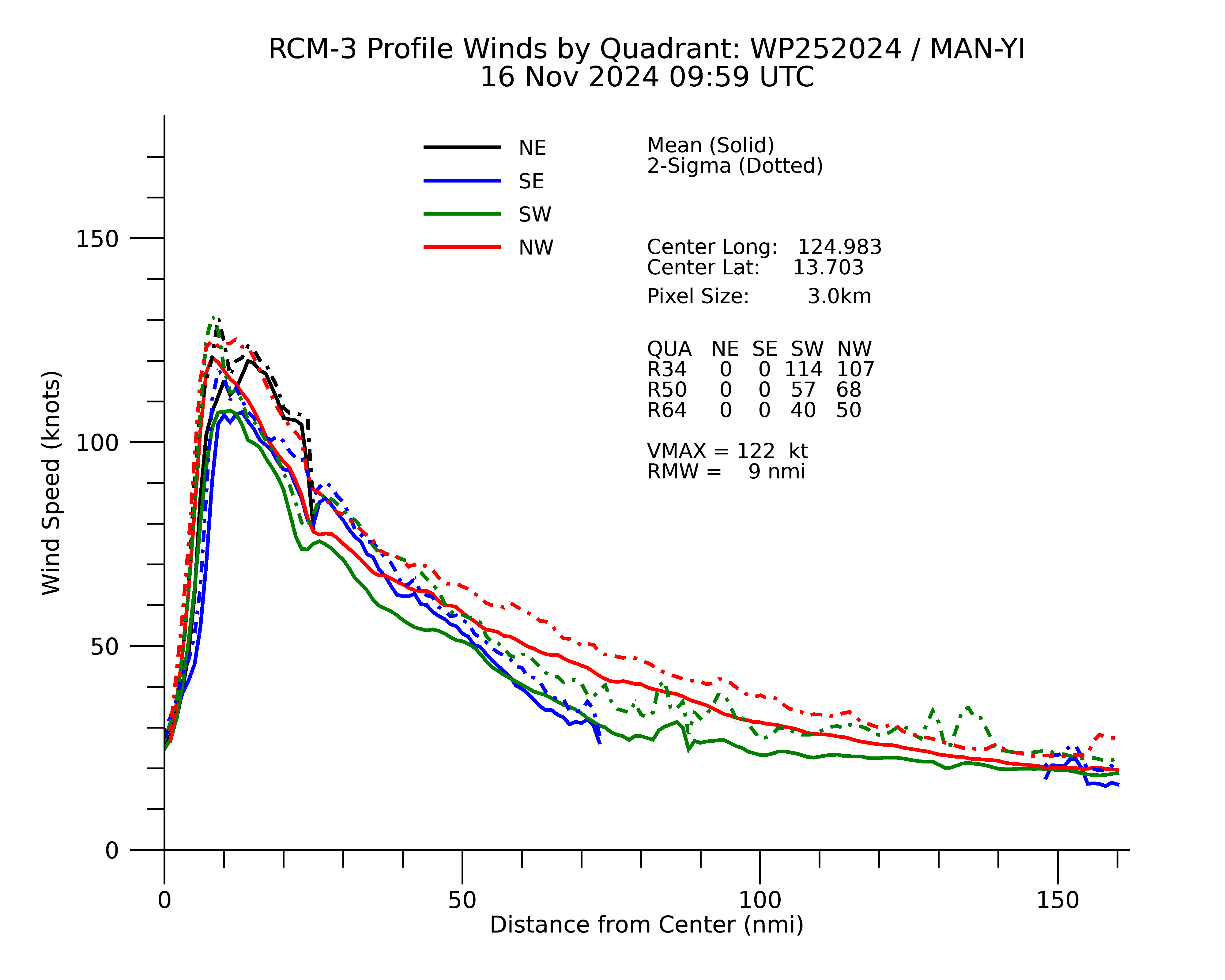
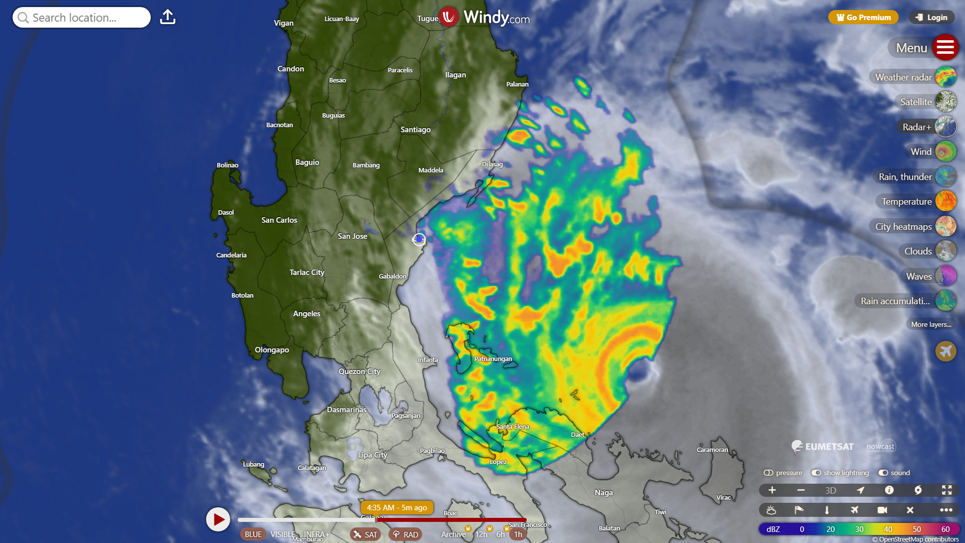
xtyphooncyclonex wrote:Based on recent trends, it appears that Man-yi may scrape the northern part of Catanduanes or miss it to its north because of an apparent northerly component. Impacts would be grave, nonetheless.
A miss *may* mean it could hold up stronger than forecasts, unless an EWRC takes place.
It seems in the last frame the eye made a straight left hook right into northern part of Catanduanes.
0 likes
Personal Forecast Disclaimer:
The posts in this forum are NOT official forecast and should not be used as such. They are just the opinion of the poster and may or may not be backed by sound meteorological data. They are NOT endorsed by any professional institution or storm2k.org. For official information, please refer to the NHC and NWS products.
- mrbagyo
- Category 5
- Posts: 3711
- Age: 32
- Joined: Thu Apr 12, 2012 9:18 am
- Location: 14.13N 120.98E
- Contact:
Re: WPAC: MAN-YI - Typhoon
im also seeing a west jog
0 likes
The posts in this forum are NOT official forecast and should not be used as such. They are just the opinion of the poster and may or may not be backed by sound meteorological data. They are NOT endorsed by any professional institution or storm2k.org. For official information, please refer to RSMC, NHC and NWS products.
- xtyphooncyclonex
- Category 5
- Posts: 3857
- Age: 23
- Joined: Sat Dec 08, 2012 9:07 am
- Location: Cebu City
- Contact:
Re: WPAC: MAN-YI - Typhoon
0 likes
REMINDER: My opinions that I, or any other NON Pro-Met in this forum, are unofficial. Please do not take my opinions as an official forecast and warning. I am NOT a meteorologist. Following my forecasts blindly may lead to false alarm, danger and risk if official forecasts from agencies are ignored.
Re: WPAC: MAN-YI - Typhoon
Looks like we have landfall around the NE side of Catanduanes Island.
0 likes
Irene '11 Sandy '12 Hermine '16 5/15/2018 Derecho Fay '20 Isaias '20 Elsa '21 Henri '21 Ida '21
I am only a meteorology enthusiast who knows a decent amount about tropical cyclones. Look to the professional mets, the NHC, or your local weather office for the best information.
- mrbagyo
- Category 5
- Posts: 3711
- Age: 32
- Joined: Thu Apr 12, 2012 9:18 am
- Location: 14.13N 120.98E
- Contact:
Re: WPAC: MAN-YI - Typhoon

0 likes
The posts in this forum are NOT official forecast and should not be used as such. They are just the opinion of the poster and may or may not be backed by sound meteorological data. They are NOT endorsed by any professional institution or storm2k.org. For official information, please refer to RSMC, NHC and NWS products.
-
- Tropical Wave
- Posts: 2
- Joined: Fri Nov 08, 2024 11:12 am
Re: WPAC: MAN-YI - Typhoon
LANDFALL: The meteorologically unthinkable has happened today in the Philippines. For the 4TH time in only 10 DAYS, the nation has been hit directly by a Typhoon—and this was the strongest of them all. Category 5 Super Typhoon #ManYi (#PepitoPH) has just made a devastating landfall over the island of Catanduanes, with violent sustained winds of ~160 mph (260 kph) and a core pressure likely in the mid/upper 920s mbar, becoming the first Category 5 Typhoon to strike the Philippines since Super Typhoon Goni (Rolly) tore through this very same region in 2020. Potentially catastrophic destruction may be ongoing on the island right now. This is a truly terrifying sight.
https://x.com/BackpirchCrew/status/1857802568363057207
0 likes
- xtyphooncyclonex
- Category 5
- Posts: 3857
- Age: 23
- Joined: Sat Dec 08, 2012 9:07 am
- Location: Cebu City
- Contact:
Re: WPAC: MAN-YI - Typhoon
Eye definitely took a hit, but remains nevertheless powerful. It's back to a relatively WNW trajectory after a W wobble towards Catanduanes. Seems to be a second eyewall present/emerging too.
0 likes
REMINDER: My opinions that I, or any other NON Pro-Met in this forum, are unofficial. Please do not take my opinions as an official forecast and warning. I am NOT a meteorologist. Following my forecasts blindly may lead to false alarm, danger and risk if official forecasts from agencies are ignored.
- mrbagyo
- Category 5
- Posts: 3711
- Age: 32
- Joined: Thu Apr 12, 2012 9:18 am
- Location: 14.13N 120.98E
- Contact:
Re: WPAC: MAN-YI - Typhoon
latest SAR pass


0 likes
The posts in this forum are NOT official forecast and should not be used as such. They are just the opinion of the poster and may or may not be backed by sound meteorological data. They are NOT endorsed by any professional institution or storm2k.org. For official information, please refer to RSMC, NHC and NWS products.
Re: WPAC: MAN-YI - Typhoon
Lowest msl pressure observed in Virac occurred at 1400z at 978.8mb and the windspeed at the time of observation was 31 m/s or 60 kts.


0 likes
ヤンデレ女が寝取られるているのを見たい!!!
ECMWF ensemble NWPAC plots: https://ecmwfensnwpac.imgbb.com/
Multimodel NWPAC plots: https://multimodelnwpac.imgbb.com/
GFS Ensemble NWPAC plots (16 & 35 day forecast): https://gefsnwpac.imgbb.com/
Plots updated automatically
ECMWF ensemble NWPAC plots: https://ecmwfensnwpac.imgbb.com/
Multimodel NWPAC plots: https://multimodelnwpac.imgbb.com/
GFS Ensemble NWPAC plots (16 & 35 day forecast): https://gefsnwpac.imgbb.com/
Plots updated automatically
- mrbagyo
- Category 5
- Posts: 3711
- Age: 32
- Joined: Thu Apr 12, 2012 9:18 am
- Location: 14.13N 120.98E
- Contact:
Re: WPAC: MAN-YI - Typhoon
Concentric eyewall


1 likes
The posts in this forum are NOT official forecast and should not be used as such. They are just the opinion of the poster and may or may not be backed by sound meteorological data. They are NOT endorsed by any professional institution or storm2k.org. For official information, please refer to RSMC, NHC and NWS products.
- xtyphooncyclonex
- Category 5
- Posts: 3857
- Age: 23
- Joined: Sat Dec 08, 2012 9:07 am
- Location: Cebu City
- Contact:
Re: WPAC: MAN-YI - Typhoon
Eye back warming again and some CDO cooling.
0 likes
REMINDER: My opinions that I, or any other NON Pro-Met in this forum, are unofficial. Please do not take my opinions as an official forecast and warning. I am NOT a meteorologist. Following my forecasts blindly may lead to false alarm, danger and risk if official forecasts from agencies are ignored.
- xtyphooncyclonex
- Category 5
- Posts: 3857
- Age: 23
- Joined: Sat Dec 08, 2012 9:07 am
- Location: Cebu City
- Contact:
Re: WPAC: MAN-YI - Typhoon
0 likes
REMINDER: My opinions that I, or any other NON Pro-Met in this forum, are unofficial. Please do not take my opinions as an official forecast and warning. I am NOT a meteorologist. Following my forecasts blindly may lead to false alarm, danger and risk if official forecasts from agencies are ignored.
-
- Category 5
- Posts: 3466
- Joined: Sat Oct 24, 2009 11:50 pm
Re: WPAC: MAN-YI - Typhoon
It looks fresh from an EWRC looking at visible sat imagery but we need MW image to confirm that.
1 likes
Personal Forecast Disclaimer:
The posts in this forum are NOT official forecast and should not be used as such. They are just the opinion of the poster and may or may not be backed by sound meteorological data. They are NOT endorsed by any professional institution or storm2k.org. For official information, please refer to the NHC and NWS products.
- Hurricane2022
- Category 5
- Posts: 1496
- Joined: Tue Aug 23, 2022 11:38 pm
- Location: Araçatuba, Brazil
Re: WPAC: MAN-YI - Typhoon
Where is Josh Morgerman right now? He will be inside the Eye of Man-yi?
0 likes
Sorry for the bad English sometimes...!
For reliable and detailed information for any meteorological phenomenon, please consult the National Hurricane Center, Joint Typhoon Warning Center , or your local Meteo Center.
--------
Una cvm Christo, pro Christo, et in Christo. Sit nomen Domini benedictvm.
For reliable and detailed information for any meteorological phenomenon, please consult the National Hurricane Center, Joint Typhoon Warning Center , or your local Meteo Center.
--------
Una cvm Christo, pro Christo, et in Christo. Sit nomen Domini benedictvm.
Who is online
Users browsing this forum: No registered users and 6 guests