Winter Weather Discussion
Moderator: S2k Moderators
Forum rules
The posts in this forum are NOT official forecast and should not be used as such. They are just the opinion of the poster and may or may not be backed by sound meteorological data. They are NOT endorsed by any professional institution or
STORM2K.
-
Golfisnteasy7575
- Tropical Storm

- Posts: 156
- Joined: Sun Oct 13, 2024 7:25 pm
#81 Postby Golfisnteasy7575 » Mon Dec 02, 2024 4:10 pm
Ntxw wrote:Brent wrote:Still not an impressive signal for the day 10 storm here but I bet it's more of a setup for a storm down the road
Anytime in winter where you have strong vorticity digging into the southwest is a start. As we get closer, either it has to find cold (not seen by the models until closer) or it's strong enough to bring down some underneath (the huge wet flakes type of marginal event.) We're running near to slightly below normal so -10F anomaly can do it especially areas to the north like I-40.
I know webber believes it will be a 13-14 type winter, I just have my doubts. Imo it don't resemble that. I think other analogs make more sense
0 likes
-
Iceresistance
- Category 5

- Posts: 9522
- Age: 22
- Joined: Sat Oct 10, 2020 9:45 am
- Location: Tecumseh, OK/Norman, OK
#82 Postby Iceresistance » Mon Dec 02, 2024 4:13 pm
0 likes
Bill 2015 & Beta 2020
Winter 2020-2021 
All observations are in Tecumseh, OK unless otherwise noted.
Winter posts are focused mainly for Oklahoma & Texas.
Take any of my forecasts with a grain of salt, refer to the NWS, SPC, and NHC for official information
Never say
Never with weather! Because
ANYTHING is possible!
-
Stratton23
- Category 5

- Posts: 3377
- Joined: Fri Jul 21, 2023 10:59 pm
- Location: Katy, Tx
#83 Postby Stratton23 » Mon Dec 02, 2024 4:22 pm
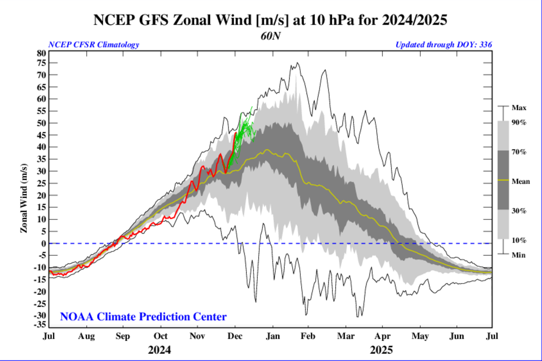
Iceresistance normally that would bottle up all the arctic air, however their does look to be several exceptions this season, Juda Cohen is an expert on polar vortex forecasting and he says that high latitude blocking in the arctic is helping to counteract the strong PV, because the tropospheric PV is likely going to become a mostly permanent feature on the NA side of the globe, I suspect we will have some big arctic cold fronta despite the strong PV, its a very interesting situation, not a typical pattern you would see when dealing with a strong PV
0 likes
-
Stratton23
- Category 5

- Posts: 3377
- Joined: Fri Jul 21, 2023 10:59 pm
- Location: Katy, Tx
#84 Postby Stratton23 » Mon Dec 02, 2024 4:23 pm
Notice on the 12z Euro which has the Tropospheric PV on our side of the globe in central canada, thats going to help to build up a really cold air pool in western canada which is eventually going to get dumped into the US
0 likes
-
Stratton23
- Category 5

- Posts: 3377
- Joined: Fri Jul 21, 2023 10:59 pm
- Location: Katy, Tx
#85 Postby Stratton23 » Mon Dec 02, 2024 5:37 pm
Ntxw looks like the 18z GFS did make a good shift south with the trough, digging more SW like the CMC, much colder too, precipitation moves out too fast though, still a good trend though
2 likes
-
Ntxw
- Storm2k Moderator

- Posts: 23335
- Joined: Wed Oct 21, 2009 6:34 pm
- Location: DFW, Texas
#86 Postby Ntxw » Mon Dec 02, 2024 11:17 pm
Not to be lost in it all, Friday, Sat, and some of Sunday will be rainy, and chilly for the I-35 to I-45 corridor in the eastern half to third of the state. 40s and chilly rain most of the time.
1 likes
The above post and any post by Ntxw is NOT an official forecast and should not be used as such. It is just the opinion of the poster and may or may not be backed by sound meteorological data. It is NOT endorsed by any professional institution including Storm2k. For official information, please refer to NWS products.
Help support Storm2K!
-
Brent
- S2K Supporter

- Posts: 38611
- Age: 37
- Joined: Sun May 16, 2004 10:30 pm
- Location: Tulsa Oklahoma
-
Contact:
#87 Postby Brent » Mon Dec 02, 2024 11:27 pm
The GFS says this might be the perfect weekend to go to Breckenridge

a foot in 12 hours near Denver

I'm really hoping that storm lays the groundwork for our pattern flip if nothing else happens down here
Last edited by
Brent on Mon Dec 02, 2024 11:33 pm, edited 1 time in total.
0 likes
#neversummer
-
Ntxw
- Storm2k Moderator

- Posts: 23335
- Joined: Wed Oct 21, 2009 6:34 pm
- Location: DFW, Texas
#88 Postby Ntxw » Mon Dec 02, 2024 11:31 pm
Brent wrote:The GFS says this might be the perfect weekend to go to Breckenridge

The models are all over place with vorticity, some hanging back, some have three or more pieces hundreds of miles apart, some rush the front end and so on...signal is growing for a major system though, just no idea where it will go or how it will play out.
0 likes
The above post and any post by Ntxw is NOT an official forecast and should not be used as such. It is just the opinion of the poster and may or may not be backed by sound meteorological data. It is NOT endorsed by any professional institution including Storm2k. For official information, please refer to NWS products.
Help support Storm2K!

-
Stratton23
- Category 5

- Posts: 3377
- Joined: Fri Jul 21, 2023 10:59 pm
- Location: Katy, Tx
#89 Postby Stratton23 » Mon Dec 02, 2024 11:46 pm
CMC with a classic coastal low setup for texas, minor winter storm, snow sleet and some ice for central and north texas, highs in the mid 30’s, GFS not there yet, but still highs in the mid 40’s
1 likes
-
Lagreeneyes03
- Category 2

- Posts: 597
- Joined: Mon Dec 09, 2013 10:53 am
- Location: Luxurious Lake Grapevine
#90 Postby Lagreeneyes03 » Tue Dec 03, 2024 4:10 am
Ntxw wrote:Not to be lost in it all, Friday, Sat, and some of Sunday will be rainy, and chilly for the I-35 to I-45 corridor in the eastern half to third of the state. 40s and chilly rain most of the time.
The absolute worst waste of precipitation. There is nothing worse than cold rain.
2 likes
I'm a Princess, not a forecaster.
-
wxman22
- Category 5

- Posts: 1790
- Joined: Mon Jan 30, 2006 12:39 am
- Location: Wichita Falls, TX
-
Contact:
#91 Postby wxman22 » Tue Dec 03, 2024 9:47 am
FWIW the overnight Euro and 6z GFS trended towards the Canadian model in regards to the potential storm around the 10th.
1 likes
-
Ntxw
- Storm2k Moderator

- Posts: 23335
- Joined: Wed Oct 21, 2009 6:34 pm
- Location: DFW, Texas
#92 Postby Ntxw » Tue Dec 03, 2024 11:21 am
The coming system is trending in the direction of digging very far to the south in the southwest. After days of showing no cold air in W-Can the GFS has somehow found some to spill into the trof. That ridge off the west coast 591+ dm heights at 500mb will make it easy to dig.
Also upper 30s and low 40s raining on Friday for parts of NTX.
1 likes
The above post and any post by Ntxw is NOT an official forecast and should not be used as such. It is just the opinion of the poster and may or may not be backed by sound meteorological data. It is NOT endorsed by any professional institution including Storm2k. For official information, please refer to NWS products.
Help support Storm2K!

-
Sambucol2024
- Tropical Storm

- Posts: 101
- Joined: Mon Feb 26, 2024 1:54 pm
#93 Postby Sambucol2024 » Tue Dec 03, 2024 11:30 am
Ntxw wrote:The coming system is trending in the direction of digging very far to the south in the southwest. After days of showing no cold air in W-Can the GFS has somehow found some to spill into the trof. That ridge off the west coast 591+ dm heights at 500mb will make it easy to dig.
Also upper 30s and low 40s raining on Friday for parts of NTX.
Does the Houston area get anything out of this system?
0 likes
-
Ntxw
- Storm2k Moderator

- Posts: 23335
- Joined: Wed Oct 21, 2009 6:34 pm
- Location: DFW, Texas
#94 Postby Ntxw » Tue Dec 03, 2024 11:33 am
Sambucol2024 wrote:Ntxw wrote:The coming system is trending in the direction of digging very far to the south in the southwest. After days of showing no cold air in W-Can the GFS has somehow found some to spill into the trof. That ridge off the west coast 591+ dm heights at 500mb will make it easy to dig.
Also upper 30s and low 40s raining on Friday for parts of NTX.
Does the Houston area get anything out of this system?
Lots of rain if it comes out with negative tilt, doesn't show much wintry precip for anyone yet except maybe out in Abilene and that region for now.
0 likes
The above post and any post by Ntxw is NOT an official forecast and should not be used as such. It is just the opinion of the poster and may or may not be backed by sound meteorological data. It is NOT endorsed by any professional institution including Storm2k. For official information, please refer to NWS products.
Help support Storm2K!

-
TeamPlayersBlue
- Category 5

- Posts: 3522
- Joined: Tue Feb 02, 2010 1:44 am
- Location: Denver/Applewood, CO
#95 Postby TeamPlayersBlue » Tue Dec 03, 2024 11:36 am
The path of that storm (looking at the Euro) would be perfect for Texas, if it dipped just a tad further south, but its a start. A storm where the vort max swings into the big bend region should do the trick.
0 likes
Personal Forecast Disclaimer:
The posts in this forum are NOT official forecast and should not be used as such. They are just the opinion of the poster and may or may not be backed by sound meteorological data. They are NOT endorsed by any professional institution or storm2k.org. For official information, please refer to the NHC and NWS products.
-
Ntxw
- Storm2k Moderator

- Posts: 23335
- Joined: Wed Oct 21, 2009 6:34 pm
- Location: DFW, Texas
#96 Postby Ntxw » Tue Dec 03, 2024 11:41 am
TeamPlayersBlue wrote:The path of that storm (looking at the Euro) would be perfect for Texas, if it dipped just a tad further south, but its a start. A storm where the vort max swings into the big bend region should do the trick.
Some of our bigger marginal events have come with the help of a huge ridge off the Cali coast. It really buckles the heights over the west and allow the energy to dig much further south than usual. It also helps push whatever cold is there into the system, due to increased surface high pressure over the Great Basin.


6 likes
The above post and any post by Ntxw is NOT an official forecast and should not be used as such. It is just the opinion of the poster and may or may not be backed by sound meteorological data. It is NOT endorsed by any professional institution including Storm2k. For official information, please refer to NWS products.
Help support Storm2K!

-
wxman22
- Category 5

- Posts: 1790
- Joined: Mon Jan 30, 2006 12:39 am
- Location: Wichita Falls, TX
-
Contact:
#97 Postby wxman22 » Tue Dec 03, 2024 11:57 am
The 500mb setup the models are showing late next week is a classic for winter storms in the southern plains. Not convinced we will see a storm yet but watching the trends. We’ll know more during the weekend.
2 likes
-
Ntxw
- Storm2k Moderator

- Posts: 23335
- Joined: Wed Oct 21, 2009 6:34 pm
- Location: DFW, Texas
#98 Postby Ntxw » Tue Dec 03, 2024 11:59 am
wxman22 wrote:The 500mb setup the models are showing is a classic for winter storms in the southern plains. Not convinced we will see a storm yet but watching the trends. We’ll know more during the weekend.
If there is an event, it may play out like Christmas period 2004 at the 500mb level. Doesn't mean it will be the same areas getting wintry precip due to different air mass, and other factors but still...this wasn't much in play last week was a blip passing piece of energy.
Even more exciting, so far this cold season energy has been able to dig and strengthen over the Southern Rockies and Plains one after another. Might be a sign this is where the winter storm track will be. Get this train going Jan and Feb you'll have winter storm after winter storm.
6 likes
The above post and any post by Ntxw is NOT an official forecast and should not be used as such. It is just the opinion of the poster and may or may not be backed by sound meteorological data. It is NOT endorsed by any professional institution including Storm2k. For official information, please refer to NWS products.
Help support Storm2K!

-
Stratton23
- Category 5

- Posts: 3377
- Joined: Fri Jul 21, 2023 10:59 pm
- Location: Katy, Tx
#99 Postby Stratton23 » Tue Dec 03, 2024 12:02 pm
the 12z CMC brings a lobe of the TPV down to the US/Canadian central border
1 likes
-
Fifty Rock
- Tropical Storm

- Posts: 120
- Joined: Mon Sep 11, 2023 10:08 am
- Location: Albany, Texas
#100 Postby Fifty Rock » Tue Dec 03, 2024 12:33 pm
Ntxw wrote:Sambucol2024 wrote:Ntxw wrote:The coming system is trending in the direction of digging very far to the south in the southwest. After days of showing no cold air in W-Can the GFS has somehow found some to spill into the trof. That ridge off the west coast 591+ dm heights at 500mb will make it easy to dig.
Also upper 30s and low 40s raining on Friday for parts of NTX.
Does the Houston area get anything out of this system?
Lots of rain if it comes out with negative tilt, doesn't show much wintry precip for anyone yet except maybe out in Abilene and that region for now.
Can you show what you’re talking about out around Abilene area?
0 likes
Return to “Winter Weather”
Who is online
Users browsing this forum: bevolon, Brandon8181, Brazoria979cnty, bubba hotep, CaptinCrunch, cheezyWXguy, chickypez, cmpcpa99, Cpv17, cstrunk, dfw_toadie, downsouthman1, gboudx, Gotwood, Greener, Iceresistance, iorange55, JayDT, Longhornmaniac8, orangeblood, Ralph's Weather, rendihess, rwfromkansas, rylo7956, South Texas Storms, Tammie, Texas Snow, texsn95, ThunderSleetDreams, TomballEd, TropicalTundra, utpmg, UTSARoadrunner4, WeatherNewbie, WeatherP1, Winter_Wisher, wxman22 and 390 guests