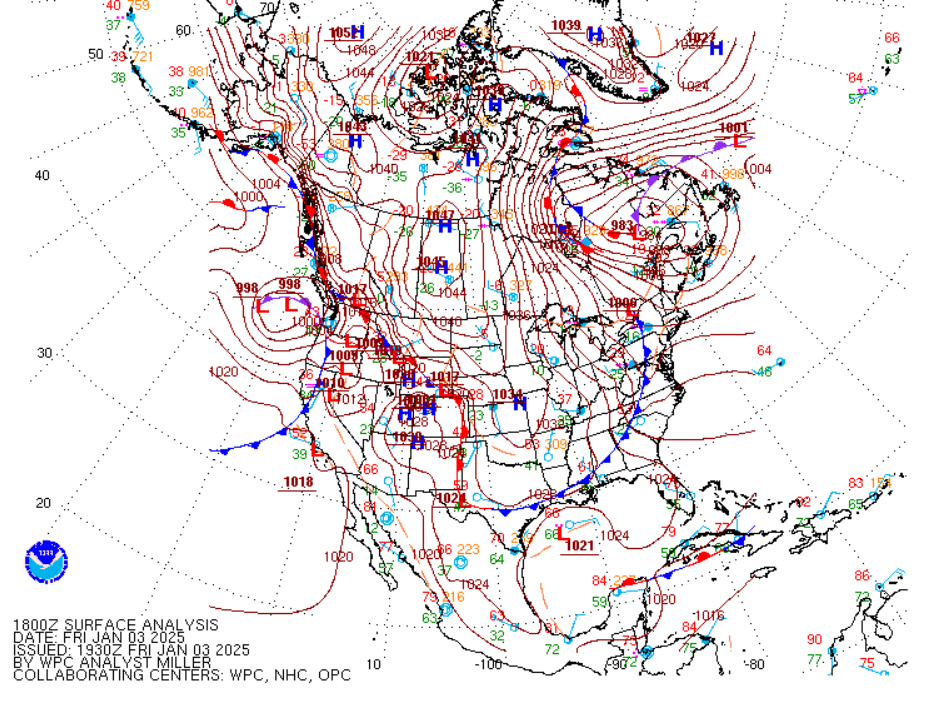
txtwister78 wrote:18z GFS looking a few degrees warmer and slower.
Yehh I’m not liking this run much. Gfs holding the system back and keeps it more separated from the trough. Not as bad as the 6z, but not much better.
Moderator: S2k Moderators
 The posts in this forum are NOT official forecast and should not be used as such. They are just the opinion of the poster and may or may not be backed by sound meteorological data. They are NOT endorsed by any professional institution or STORM2K.


txtwister78 wrote:18z GFS looking a few degrees warmer and slower.

cheezyWXguy wrote:txtwister78 wrote:18z GFS looking a few degrees warmer and slower.
Yehh I’m not liking this run much. Gfs holding the system back and keeps it more separated from the trough. Not as bad as the 6z, but not much better.


bubba hotep wrote:Kind of liking some of the trends on the 18z GFS, let's see if that makes any difference in the end.
Stratton23 wrote:The difference of where the energy is at day 3 on the GFS compared to the ICON is comical, im still leaning towards a more progressive solution though

bubba hotep wrote:bubba hotep wrote:Kind of liking some of the trends on the 18z GFS, let's see if that makes any difference in the end.
Why won't you move off the Baja!?!?!
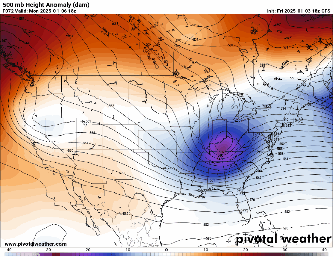
txtwister78 wrote:Stratton23 wrote:The difference of where the energy is at day 3 on the GFS compared to the ICON is comical, im still leaning towards a more progressive solution though
Really is a race against time as I felt it would be. Just was never that impressed with this pattern in general despite some of the earlier model runs that had us much colder going into next week. Even the cold that is headed our way early next week looks borderline but would probably be enough if we got the system a day earlier than what the GFS and Euro currently show.
Ensembles should really begin to hone in now. If we see those go more snow then I think we can begin to look at operationals changing their tune soon to a different scenario but that should become much clearer over the weekend.
orangeblood wrote:txtwister78 wrote:Stratton23 wrote:The difference of where the energy is at day 3 on the GFS compared to the ICON is comical, im still leaning towards a more progressive solution though
Really is a race against time as I felt it would be. Just was never that impressed with this pattern in general despite some of the earlier model runs that had us much colder going into next week. Even the cold that is headed our way early next week looks borderline but would probably be enough if we got the system a day earlier than what the GFS and Euro currently show.
Ensembles should really begin to hone in now. If we see those go more snow then I think we can begin to look at operationals changing their tune soon to a different scenario but that should become much clearer over the weekend.
If the energy stays far enough east, there’s plenty of cold to the north and northeast to tap into…as with most every winter weather setup in Texas, all about timing. If it were colder and polar jet stronger, the system would get swallowed up with little or no precip. This is a better scenario IMO - whether the ULL cuts off or not and Polar Jet a little weaker than we first thought. It’s always complicated but this seems to have added complexities that make this really difficult to pin down.
Stratton23 wrote:GEFS 18z really starting to back off on a snowfall signal, this is just laughable at this point

Harp.1 wrote:Bottom line is there is simply not enough cold air anymore. It seemed that the cold was a certainty and precip was a question. Now, it’s just the opposite. Sheesh!!!
Harp.1 wrote:Bottom line is there is simply not enough cold air anymore. It seemed that the cold was a certainty and precip was a question. Now, it’s just the opposite. Sheesh!!!
Users browsing this forum: wxman22 and 23 guests