Texas Winter 2024-2025
Moderator: S2k Moderators
Forum rules
 The posts in this forum are NOT official forecast and should not be used as such. They are just the opinion of the poster and may or may not be backed by sound meteorological data. They are NOT endorsed by any professional institution or STORM2K.

The posts in this forum are NOT official forecast and should not be used as such. They are just the opinion of the poster and may or may not be backed by sound meteorological data. They are NOT endorsed by any professional institution or STORM2K.

Re: Texas Winter 2024-2025
Tonight's 0z NAM runs will show up through Thursday 12z which is when the Euro starts the more expansive precip shield. Could be some wild convective showings from it.
4 likes
The above post and any post by Ntxw is NOT an official forecast and should not be used as such. It is just the opinion of the poster and may or may not be backed by sound meteorological data. It is NOT endorsed by any professional institution including Storm2k. For official information, please refer to NWS products.
Help support Storm2K!
-
TeamPlayersBlue

- Category 5

- Posts: 3524
- Joined: Tue Feb 02, 2010 1:44 am
- Location: Denver/Applewood, CO
Re: Texas Winter 2024-2025
Looks like a Dream storm coming for you guys in the DFW area. No more crying about missing the events up there! 
Any word on jets sampling the data in the pacific? I think once they gather data from that region, it should help the models even more.
Something to note, JB always says if you have thunderstorms roll through, one week later you can expect snow. Interesting that this wise tale is playing out for many.
2 likes
Personal Forecast Disclaimer:
The posts in this forum are NOT official forecast and should not be used as such. They are just the opinion of the poster and may or may not be backed by sound meteorological data. They are NOT endorsed by any professional institution or storm2k.org. For official information, please refer to the NHC and NWS products.
The posts in this forum are NOT official forecast and should not be used as such. They are just the opinion of the poster and may or may not be backed by sound meteorological data. They are NOT endorsed by any professional institution or storm2k.org. For official information, please refer to the NHC and NWS products.
-
Brandon8181
- S2K Supporter

- Posts: 431
- Age: 42
- Joined: Tue Jan 04, 2011 4:52 pm
- Location: Tyler, TX
- Contact:
Re: Texas Winter 2024-2025
TeamPlayersBlue wrote:Looks like a Dream storm coming for you guys in the DFW area. No more crying about missing the events up there!
Any word on jets sampling the data in the pacific? I think once they gather data from that region, it should help the models even more.
Something to note, JB always says if you have thunderstorms roll through, one week later you can expect snow. Interesting that this wise tale is playing out for many.
Is there any kind of science at all behind this (at all?) Or only a wise tale?
0 likes
I am not a meteorologist. Any post from me should be taken as hobby or fun educational information, but not an accurate source for weather information. Please, refer to your local weather station or National Weather Service for the most up to date information. 

Re: Texas Winter 2024-2025
Iceresistance wrote:It's snowing! With tiny flakes!
23°F with a WC of 7°F
It's really picked up here in Edmond. Had a 1% chance per TWC and have a little sticking to the roofs and the grass!
2 likes
-
ThunderSleetDreams

- S2K Supporter
- Posts: 1510
- Age: 43
- Joined: Tue Dec 20, 2011 4:42 pm
- Location: S of Weimar, TX
Re: Texas Winter 2024-2025
Brandon8181 wrote:TeamPlayersBlue wrote:Looks like a Dream storm coming for you guys in the DFW area. No more crying about missing the events up there!
Any word on jets sampling the data in the pacific? I think once they gather data from that region, it should help the models even more.
Something to note, JB always says if you have thunderstorms roll through, one week later you can expect snow. Interesting that this wise tale is playing out for many.
Is there any kind of science at all behind this (at all?) Or only a wise tale?
It’s folklore, but there is some legitimacy to it. Usually thunderstorms in Winter is a precursor to a major pattern shakeup.
2 likes
#NeverSummer
I hibernate when it gets above 75 degrees!
I hibernate when it gets above 75 degrees!
-
Iceresistance

- Category 5
- Posts: 9565
- Age: 22
- Joined: Sat Oct 10, 2020 9:45 am
- Location: Tecumseh, OK/Norman, OK
Re: Texas Winter 2024-2025
Snowflakes getting larger and more visible, also coming down heavier too!
23°F with a WC of 7°F
23°F with a WC of 7°F
5 likes
Bill 2015 & Beta 2020
Winter 2020-2021
All observations are in Tecumseh, OK unless otherwise noted.
Winter posts are focused mainly for Oklahoma & Texas.
Take any of my forecasts with a grain of salt, refer to the NWS, SPC, and NHC for official information
Never say Never with weather! Because ANYTHING is possible!
Winter 2020-2021
All observations are in Tecumseh, OK unless otherwise noted.
Winter posts are focused mainly for Oklahoma & Texas.
Take any of my forecasts with a grain of salt, refer to the NWS, SPC, and NHC for official information
Never say Never with weather! Because ANYTHING is possible!

Re: Texas Winter 2024-2025
Late Jan 1966 and 1978 analogs joining the group in the week 2 period (late Jan.) Though I would weigh them a bit lighter than 1985 due to El Nino. Nonetheless they are very snowy.
7 likes
The above post and any post by Ntxw is NOT an official forecast and should not be used as such. It is just the opinion of the poster and may or may not be backed by sound meteorological data. It is NOT endorsed by any professional institution including Storm2k. For official information, please refer to NWS products.
Help support Storm2K!
Help support Storm2K!
-
bubba hotep

- S2K Supporter
- Posts: 6012
- Joined: Wed Dec 28, 2016 1:00 am
- Location: Collin County Texas
Re: Texas Winter 2024-2025
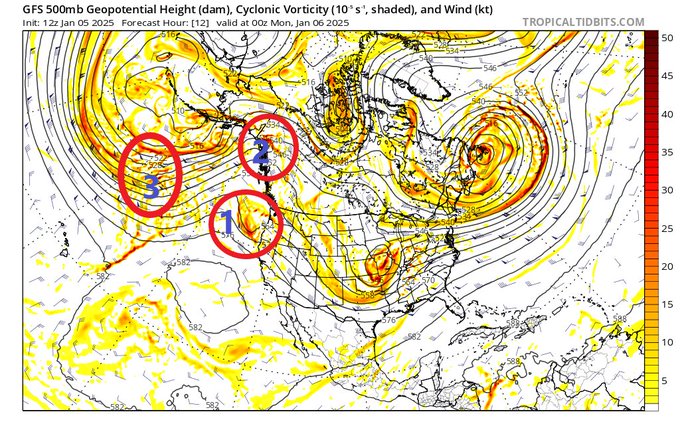
The Euro EPS seems locked in, but we still have a long way to go. We are still about 12 hrs from 1 & 2 moving onshore and getting sampled better (I wish they would have flown an upper-level mission over the North Pacific). Then 3 is still way out in the North Pacific. That makes me nervous as a lot can change as we wait for it to crash down the Rockies and into our system. Too many moving parts to make me feel good 
4 likes
Winter time post are almost exclusively focused on the DFW area.


-
bubba hotep
- S2K Supporter
- Posts: 6012
- Joined: Wed Dec 28, 2016 1:00 am
- Location: Collin County Texas
Re: Texas Winter 2024-2025
foulbeast wrote:http://www.weather.gov/images/fwd/graphicast/image2.jpg
IMHO, if the rain/snow line is that far south, then DFW is cashing in!
4 likes
Winter time post are almost exclusively focused on the DFW area.


-
Portastorm

- Storm2k Moderator

- Posts: 9954
- Age: 63
- Joined: Fri Jul 11, 2003 9:16 am
- Location: Round Rock, TX
- Contact:
Re: Texas Winter 2024-2025
bubba hotep wrote:The Euro EPS seems locked in, but we still have a long way to go. We are still about 12 hrs from 1 & 2 moving onshore and getting sampled better (I wish they would have flown an upper-level mission over the North Pacific). Then 3 is still way out in the North Pacific. That makes me nervous as a lot can change as we wait for it to crash down the Rockies and into our system. Too many moving parts to make me feel good
https://pbs.twimg.com/media/GgjoHhTWkAAtu2m?format=jpg&name=small
Very good and informative post here! This is why folks shouldn't get too up or down about any specific model run. A lot to still determine and small, subtle changes in the real-time weather can have larger impacts down the road.
5 likes
Any forecasts under my name are to be taken with a grain of salt. Get your best forecasts from the National Weather Service and National Hurricane Center.
-
wxman57

- Moderator-Pro Met

- Posts: 23170
- Age: 68
- Joined: Sat Jun 21, 2003 8:06 pm
- Location: Houston, TX (southwest)
Re: Texas Winter 2024-2025
12Z EC has about 12" of snow up there in DFW. Hope you get your fill so we can move on to summer. Here in Houston, upper 30s and rain.
8 likes
-
txtwister78

- Category 5
- Posts: 2136
- Joined: Wed Jan 30, 2019 12:56 pm
- Location: San Antonio
Re: Texas Winter 2024-2025
Austin/San Antonio forecast office seems to be more bullish on at least mixed precip types next week across the region including the possibility of getting into the major metros. Still some things to iron out obviously but interesting discussion given some of the global model uncertainty.
LONG TERM...
(Tuesday through Sunday)
Issued at 254 PM CST Sun Jan 5 2025
Key Messages...
- High confidence on a cold week with below normal climate
temperatures.
- There is moderate to high confidence on precipitation
from Wednesday afternoon/evening through Friday.
- Confidence increasing for all precipitation types
Cold weather conditions continue across South Central Texas through
the extended forecast period. Dry conditions are in place for
Tuesday and part of Wednesday. By Wednesday afternoon into the
evening continuing through Thursday morning, the weather pattern
changes as an upper level low pressure system over northwest Mexico
moves to the southeast. At low to mid levels, increased moisture
arrives across South Central Texas with 850 mb and 700 mb levels
coming in saturated per forecast soundings. There is a slight to low
end chances for precipitation during the Wednesday afternoon/evening
period into Thursday morning with temperatures reaching the freezing
mark and as low as 25/26 degrees over the southern Edwards Plateau,
upper 20s to lower 30s over portions of the Hill Country including
the Austin and San Antonio metro areas and 31 to 33 degrees along I-
35 corridor and coastal plains. All precipitation types are
possible, however, amounts and impacts are still hard to determine
with a large spread of solutions this far out.
A second round of increased moisture arrives during the day on
Thursday as the upper level low opens while moving across central
Mexico and then pulls to the northeast to push across the local area.
During this period, chances for precipitation has increased (40-70)
with temperatures above freezing during the day on Thursday but
dropping to 32 degrees and below Thursday evening into Friday
morning. For this second round of precipitation, our confidence is
increasing as far as seeing all precipitation types with wintry mix
over parts of the Rio Grande, southern Edwards Plateau, and Hill
Country. Once again, amounts and impacts are hard to pinpoint at
this time, however, we are looking forward to be entering into the
hires time frame to offer more details as this cold weather week
evolves.
2 likes
-
Yukon Cornelius
- S2K Supporter
- Posts: 1838
- Age: 42
- Joined: Thu Dec 20, 2012 9:23 pm
- Location: Dean, TX/Westcliffe, CO
Re: Texas Winter 2024-2025
wxman22 wrote:https://i.ibb.co/Rht79Kc/image-full8.png
Voting for track 2
3 likes
#neversummer
-
SnowintheFalls

- S2K Supporter
- Posts: 283
- Age: 48
- Joined: Fri Nov 22, 2013 5:06 pm
- Location: Burkburnett, TX

Re: Texas Winter 2024-2025
Yukon Cornelius wrote:wxman22 wrote:https://i.ibb.co/Rht79Kc/image-full8.png
Voting for track 2
Seems like that’s what the latest ICON did
1 likes
-
cheezyWXguy

- Category 5
- Posts: 6280
- Joined: Mon Feb 13, 2006 12:29 am
- Location: Dallas, TX
Re: Texas Winter 2024-2025
This is…interesting. If I remember correctly the icon does not depict mixed precip and only shows it as rain. If so, this run makes me nervous about impacts to the southern half of the metro.
0 likes
Who is online
Users browsing this forum: AnnularCane, Brent and 37 guests