Texas Winter 2024-2025
Moderator: S2k Moderators
Forum rules
 The posts in this forum are NOT official forecast and should not be used as such. They are just the opinion of the poster and may or may not be backed by sound meteorological data. They are NOT endorsed by any professional institution or STORM2K.

The posts in this forum are NOT official forecast and should not be used as such. They are just the opinion of the poster and may or may not be backed by sound meteorological data. They are NOT endorsed by any professional institution or STORM2K.
-
Stratton23
- Category 5

- Posts: 3503
- Joined: Fri Jul 21, 2023 10:59 pm
- Location: Katy, Tx
Re: Texas Winter 2024-2025
By day 9 the 00z Euro has a new Alaskan ridge really beginning to amplify with a trough dropping down into the west central US, looking like another extremely cold run
5 likes
-
HockeyTx82
- S2K Supporter

- Posts: 2776
- Joined: Tue Oct 27, 2009 11:17 am
- Location: Ponder, TX
Re: Texas Winter 2024-2025
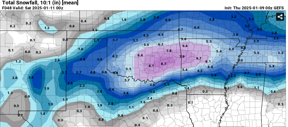
Iceresistance wrote:HockeyTx82 wrote:Iceresistance wrote:GEFS jumped north and west, and the bullseye is just to my east!
https://s7.gifyu.com/images/SXZTd.png
https://s7.gifyu.com/images/SXZTd.png
Okay seriously what's going on? I fall asleep on the couch and I wake up and now snow is in Oklahoma? Is this a trend or just one run?
What's the HRRR doing?
It has trended towards Oklahoma, I am very surprised that happened too
https://s7.gifyu.com/images/SXZhF.gif
https://s7.gifyu.com/images/SXZhF.gif
Okay my bad, I was just going off of what he replied here.
2 likes
Don't hold me accountable for anything I post on this forum. Leave the real forecasting up to the professionals.
Location: Ponder, TX (all observation posts are this location unless otherwise noted)
Location: Ponder, TX (all observation posts are this location unless otherwise noted)
Re: Texas Winter 2024-2025
This is pretty much the most wake up and look out your window type setup I think I have ever tracked. Headache inducing flip flopping craziness. I love it.
2 likes
-
HockeyTx82
- S2K Supporter
- Posts: 2776
- Joined: Tue Oct 27, 2009 11:17 am
- Location: Ponder, TX
Re: Texas Winter 2024-2025
Texas Snow wrote:You need to look The maps people post better. The hrrr said no such thing. In fact it hasn’t run a full cycle since you fell asleep probably. He only posted gefs.
I was just commenting on what the reply to my post was. My bad, back to bed
2 likes
Don't hold me accountable for anything I post on this forum. Leave the real forecasting up to the professionals.
Location: Ponder, TX (all observation posts are this location unless otherwise noted)
Location: Ponder, TX (all observation posts are this location unless otherwise noted)
-
Texas Snow

- S2K Supporter
- Posts: 817
- Joined: Mon Oct 19, 2015 12:06 pm
- Location: N. Dallas & Cedar Creek Lake
Re: Texas Winter 2024-2025
gpsnowman wrote:A winter storm will pass over north Texas Thursday into Friday morning bringing all types of precipitation. We are fortunate that temperatures will be fluctuating back and forth across the freezing point instead of staying below freezing throughout the entire event. Otherwise, this could be a lot worse.
But it is this bobbing back and forth across 32°F which makes forecasting precipitation type AMOUNTS so difficult. Not only do you have to forecast how much sleet, freezing rain, and snow will fall, you also have to calculate how much of it will melt at the same time!
If temps stayed below freezing we would be looking at over a foot of snow in many areas. But since there will be many locations that will bump above 32°F, some significant melting will be occurring in between the falling of sleet and snow. And feezing rain will transition back to just cold rain from time to time before it goes back to freezing rain again.
Although we will see a wintry mix throughout the day Thursday, it will be at its heaviest Thursday night. This is especially true when it comes to the complete transition to snow.
And this snow will be a gloppy wet snow, and in many locations, the flakes will be HUGE, especially Thursday night ! Many parts of north Texas are gonna look like a snow globe.
But keep this in mind: if the forecast surface temperatures are off by as little as 1 degree, this will have a MAJOR impact on the predicted amounts of each precipitation type.
For example, if the temperature turns out to be just 1 or 2 degrees warmer, much of this activity will turn into a cold rain. But if it turns out to be 1 or 2 degrees colder than predicted, the storm will produce higher snow and ice amounts. (To be honest, I was tempted to increase this map's snowfall amounts just in case it does turn out to be colder than expected)
Yes, it is going to be that close! That is why this forecast map will likely have errors in it when all is said and done.
Stay safe and warm and be thankful temperatures won't be in the 20s when this thing passes overhead!
Latest from Steve McCauley
I noticed his graphic had 1-2” of additional sleet in addition to the snow
3 likes
"Don't let wishcastin get in the way of your forecastin"

-
Ralph's Weather
- S2K Supporter
- Posts: 3371
- Age: 38
- Joined: Fri Dec 13, 2013 11:55 am
- Location: Lindale, TX
- Contact:
Re: Texas Winter 2024-2025
HockeyTx82 wrote:Ralph's Weather wrote:No models besides crazy Canadian are close to cold enough at initialization. Canadian is way too cold. Bizarre that all hi res models are initializing around 4 degrees warm right now. Most models have freeze line along I20 when it is actually south of Lufkin. 26 here in Lindale along I20 now. Some stations as low as 23 around East Texas.
At this point I don't think temperatures are a problem, it looks like everything is going well North into Oklahoma
I don't see that in the data at all. 1" QPF in TX and much less in OK. Issue is as it has been with how much WAA we end up with south of I30. It's a given that I30 is gonna get crushed. But what happens along I20? I am still very bullish on the southern potential of this event.
3 likes
Follow on Facebook at Ralph's Weather.
-
rwfromkansas
- Category 5
- Posts: 3012
- Joined: Sat Aug 27, 2005 12:47 am
- Location: North Fort Worth
Re: Texas Winter 2024-2025
Ralph's Weather wrote:HockeyTx82 wrote:Ralph's Weather wrote:No models besides crazy Canadian are close to cold enough at initialization. Canadian is way too cold. Bizarre that all hi res models are initializing around 4 degrees warm right now. Most models have freeze line along I20 when it is actually south of Lufkin. 26 here in Lindale along I20 now. Some stations as low as 23 around East Texas.
At this point I don't think temperatures are a problem, it looks like everything is going well North into Oklahoma
I don't see that in the data at all. 1" QPF in TX and much less in OK. Issue is as it has been with how much WAA we end up with south of I30. It's a given that I30 is gonna get crushed. But what happens along I20? I am still very bullish on the southern potential of this event.
Here in DFW I am about 2 miles north of 20 and 5 miles south of 30. Not sure what to think.
3 likes
-
Iceresistance

- Category 5
- Posts: 9571
- Age: 22
- Joined: Sat Oct 10, 2020 9:45 am
- Location: Tecumseh, OK/Norman, OK
Re: Texas Winter 2024-2025
rwfromkansas wrote:Temp going up again to 32.
I went down to 23°F before it increased to 26°F
3 likes
Bill 2015 & Beta 2020
Winter 2020-2021
All observations are in Tecumseh, OK unless otherwise noted.
Winter posts are focused mainly for Oklahoma & Texas.
Take any of my forecasts with a grain of salt, refer to the NWS, SPC, and NHC for official information
Never say Never with weather! Because ANYTHING is possible!
Winter 2020-2021
All observations are in Tecumseh, OK unless otherwise noted.
Winter posts are focused mainly for Oklahoma & Texas.
Take any of my forecasts with a grain of salt, refer to the NWS, SPC, and NHC for official information
Never say Never with weather! Because ANYTHING is possible!
-
cheezyWXguy

- Category 5
- Posts: 6280
- Joined: Mon Feb 13, 2006 12:29 am
- Location: Dallas, TX
Re: Texas Winter 2024-2025
rwfromkansas wrote:Temp going up again to 32.
Dew points will be the main metric to watch from here on out, as we’ll be relying on evaporative cooling. Right now it looks like they’re generally in the low 20s. They’ll rise as the night progresses, but if we can keep them below freezing for the duration of event the prospects of avoiding a changeover to rain increase as long as the gaps between bands aren’t very long.
2 likes
-
Ralph's Weather
- S2K Supporter
- Posts: 3371
- Age: 38
- Joined: Fri Dec 13, 2013 11:55 am
- Location: Lindale, TX
- Contact:
Re: Texas Winter 2024-2025
gpsnowman wrote:Ralph's Weather wrote:HockeyTx82 wrote:
At this point I don't think temperatures are a problem, it looks like everything is going well North into Oklahoma
I don't see that in the data at all. 1" QPF in TX and much less in OK. Issue is as it has been with how much WAA we end up with south of I30. It's a given that I30 is gonna get crushed. But what happens along I20? I am still very bullish on the southern potential of this event.
Here in DFW I am about 2 miles north of 20 and 5 miles south of 30. Not sure what to think.
Haha, DFW is is own thing. Early on you are sheet then by evening you are snow.
2 likes
Follow on Facebook at Ralph's Weather.
-
downsouthman1
- Category 2

- Posts: 706
- Age: 46
- Joined: Fri Jan 07, 2011 8:14 pm
- Location: Rowlett, TX
Re: Texas Winter 2024-2025
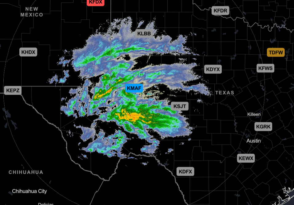
This whole thing will play out like a large May-June MCS traversing the state. Just the colors on the radar are different.
3 likes
Not a professional MET! My posts are merely speculation.
Re: Texas Winter 2024-2025
Need to sleep with a 6 am wake up call and Tommy Boy just came on. I'm screwed.
5 likes
-
Iceresistance
- Category 5
- Posts: 9571
- Age: 22
- Joined: Sat Oct 10, 2020 9:45 am
- Location: Tecumseh, OK/Norman, OK
Re: Texas Winter 2024-2025
5 likes
Bill 2015 & Beta 2020
Winter 2020-2021
All observations are in Tecumseh, OK unless otherwise noted.
Winter posts are focused mainly for Oklahoma & Texas.
Take any of my forecasts with a grain of salt, refer to the NWS, SPC, and NHC for official information
Never say Never with weather! Because ANYTHING is possible!
Winter 2020-2021
All observations are in Tecumseh, OK unless otherwise noted.
Winter posts are focused mainly for Oklahoma & Texas.
Take any of my forecasts with a grain of salt, refer to the NWS, SPC, and NHC for official information
Never say Never with weather! Because ANYTHING is possible!
Re: Texas Winter 2024-2025
Just woke up to find my temp has rose all the way to 34. Oh well atleast the schools cancelled so the kids can watch rain lol
2 likes
-
Lagreeneyes03
- Category 2
- Posts: 608
- Joined: Mon Dec 09, 2013 10:53 am
- Location: Luxurious Lake Grapevine
Re: Texas Winter 2024-2025
DFW airport went from 30 to 36 in the past 6 hours. That's concerning.
3 likes
I'm a Princess, not a forecaster.
-
snowballzzz

- Tropical Storm

- Posts: 144
- Age: 32
- Joined: Fri Dec 15, 2017 8:50 am
- Location: Sunset, TX
Re: Texas Winter 2024-2025
Fell asleep around 10pm last night and it was 24° IMBY. Currently sitting at 32°.
1 likes
-
cycloneye

- Admin

- Posts: 149192
- Age: 69
- Joined: Thu Oct 10, 2002 10:54 am
- Location: San Juan, Puerto Rico
Re: Texas Winter 2024-2025
3 likes
Visit the Caribbean-Central America Weather Thread where you can find at first post web cams,radars
and observations from Caribbean basin members Click Here
and observations from Caribbean basin members Click Here
-
DFW Stormwatcher
- Tropical Storm
- Posts: 243
- Age: 55
- Joined: Sun Dec 27, 2009 10:35 pm
- Location: Keller, Tx
Re: Texas Winter 2024-2025
Nws has increased storm total predictions, discusses temps warming up. Dew point in N Fort Worth is 21 so plenty of room for wet bulbing.
Area Forecast Discussion
National Weather Service Fort Worth TX
405 AM CST Thu Jan 9 2025
...New Short Term, Long Term...
.KEY MESSAGES...
- Winter storm begins this morning and continues through tonight.
No changes to the warning or advisory locations at this time.
- Bumped up snowfall totals a little farther south and west to 2
to 5 inches generally along and north of I-20. There is still
potential for some banded or convective snowfall which could
result in isolated totals of 8 to 10 inches. This is most likely
to occur anywhere from the northern parts of the Metroplex to
the Red River over toward Paris.
- It appears less likely that we`ll see significant ice
accumulations, but increasing likelihood that we`ll see bands of
moderate to heavy sleet across parts of North Texas, especially
along and just south of I-20. Our greatest ice accumulations
appear to be confined to our southwest counties.
- Some travel impacts are expected to begin later this morning but
will likely peak late this afternoon into tonight. Conditions
should begin to improve by Friday afternoon.
&&
.SHORT TERM... /NEW/
/Today through Friday/
Early morning water vapor imagery shows our powerful upper low
spinning over northwest Mexico beginning to eject eastward while
an upstream kicker shortwave digs sharply southward over the Four
Corners region. A notable uptick in mid and high level moisture on
water vapor is indicative of strong mid level forcing for ascent
beginning to spread eastward into Texas. This is supported by a
sharp increase in radar reflectivity well to our west this
morning. Across North Texas, the lower half of the atmosphere
still remains relatively dry as indicated by a 6Z ACARS sounding
from Dallas earlier, however, cloud heights continue to lower
suggesting that low level saturation is in progress. As
precipitation from the west begins to overspread the region early
this morning, an abrupt lowering of cloud heights is expected
along with an increase in precipitation rates.
With the increase in cloud cover and a light southeast wind,
surface temperatures have risen appreciably over the last few
hours and we`re now in the mid 30s in many locations, however
dewpoints are in the lower 20s allowing for several degrees of wet
bulb cooling potential once precipitation begins. This is already
occurring to our west where many stations have cooled 3-5 degrees
at the onset of precipitation. We should see a similar type of
response in North Texas through the early morning. Of greater
importance will be the thermal profile above the surface, as that
will completely dictate precipitation type across the region. A
closer examination of the ACARS sounding from Dallas showed a
nearly isothermal layer from just above the surface to near 700 mb
with only a small warm nose at 34 degrees around 900 mb. With
plenty of wet bulb cooling potential, this sounding would likely
be at or below freezing at the onset of precipitation. Computer
model guidance handles wet bulb cooling well and forecast
soundings for this event continue to support widespread wintry
precipitation across the region, including the potential for heavy
snow later today and tonight.
As the upper low progresses eastward this morning, we should start
to see precipitation reach the surface across our western
counties. This will likely be a combination of rain, sleet, and
perhaps some snow. Surface temperatures will be marginal for
freezing rain, but some light icing is possible as early as this
morning for our southwest counties. By mid morning, strong forcing
for ascent will begin to spread into North Texas and the thermal
profile will be dynamically cooled by this lift which will likely
result in an increase in sleet showers, some heavy, extending from
our southwest into the Metroplex. Some snow will be possible north
of I-20 and across our northwest counties, with a mostly cold rain
farther south into Central Texas. Rain is likely to prevail across
most of our Central and Southeast Texas counties through this
event, although some cold spots could see some light icing and
there will certainly be the potential for sleet.
Through midday, the event may be "so far unimpressive" with a
transition to rain/sleet mix, but the main show should really be
this afternoon and especially into the late evening hours. A band
of strong mid level frontogenesis will orient itself just to the
east of the trough axis in line with strong deep layer shear.
Dynamic cooling will likely result in a transition to all snow
across our northwest counties and northwest parts of the Metroplex
north to the Red River. Close examination of the frontal
circulation and forecast soundings during this time indicate the
potential for some conditional symmetric instability to develop
which will support the development of banded precipitation
oriented from northeast to southwest. There is even a low chance
for actual convective instability to develop producing a few
lightning strikes in convective sleet or snow showers. All of this
is most likely to occur this evening and early tonight (generally
from 5 pm through about 10 pm) and in a location from the
northern parts of the Metroplex to the Red River and over toward
Paris. A transition to all snow is expected mainly north of I-20
late tonight and overnight.
Widespread snowfall totals of 2 to 5 inches continues to be most
likely from the Metroplex northward into our northeast counties
through this event. Significantly higher totals...between 8 and
10 inches...will be possible in any bands that can develop
tonight. As mentioned above...this is most likely to occur from
the northern parts of the Metroplex toward the Red River and off
to the northeast. There is some potential for significant sleet
accumulations along the I-20 corridor prior to a transition to
snow. Farther south, snowfall accumulations will generally be 1
inch or less south of I-20 with perhaps a few isolated spots with
heavier amounts.
Concerning ice accumulations...this event really does not appear
to be shaping up to be a significant freezing rain event with
major ice accumulations. The combination of coldest temperatures,
a warm nose aloft, and persistent rainfall would be greatest
across our southwest counties this morning into early afternoon.
Surface temperatures near freezing just aren`t cold enough for
major ice accumulations on surface roads. We`ll continue to
advertise up to 1/10" of ice through this event.
Precipitation should begin to wind down late tonight as the upper
trough axis progresses eastward, however with the core of the
trough axis near the I-35 corridor early Friday morning, we could
still see some light snow persisting. All of this will end by
midday Friday with any accumulated snowfall remaining on the
ground. Any melting will likely re-freeze Friday night as low
temperatures drop into the teens and lower 20s.
Dunn
3 likes
Disclaimer: This is not an official weather forecast. I am only an amateur weather enthusiast therefore any weather forecasts or opinions should be taken with a grain of salt. Hook em Horns!
-
HockeyTx82
- S2K Supporter
- Posts: 2776
- Joined: Tue Oct 27, 2009 11:17 am
- Location: Ponder, TX
Re: Texas Winter 2024-2025
Dunn has spoken. Close the thread, it's written in stone and we don't need any further input or model watching on this one. Can't believe it's knocking on our doorstep. Amazing watching the lead up, now it's time for the main course and our dessert will be memorable snow fun!
My dewpoint is 27.9F, confirmed on my weather station.
My dewpoint is 27.9F, confirmed on my weather station.
Last edited by HockeyTx82 on Thu Jan 09, 2025 6:20 am, edited 1 time in total.
4 likes
Don't hold me accountable for anything I post on this forum. Leave the real forecasting up to the professionals.
Location: Ponder, TX (all observation posts are this location unless otherwise noted)
Location: Ponder, TX (all observation posts are this location unless otherwise noted)
Who is online
Users browsing this forum: Brent and 81 guests