TROPICAL CYCLONE number 8
(VINCE)
Maximum winds (averaged over 10 minutes) estimated at sea: 150 km/h.
Estimated maximum gusts at sea: 215 km/h.
Estimated pressure at center: 970 hPa.
Position on February 5 at 10 a.m. local time: 18.8 South / 85.6 East.
Distance from the Reunion coast: 3115 km to the sector: EAST
Distance from Mayotte: 4370 km to the sector: EAST-SOUTH-EAST
Movement: WEST, at 22 km/h.
System Information:
-After replacing the eye wall, tropical cyclone VINCE has been gaining organization in recent hours. It is evolving over the far east of our basin far from any inhabited land.
- For the next 5 days, VINCE is expected to move in a west-southwest direction while remaining at least at the tropical cyclone stage but most likely reaching the threshold of an intense tropical cyclone. Subsequently, it will take a more southwesterly direction, leaving it far from inhabited land.
- It poses no threat to inhabited land.
SIO: VINCE - Post-Tropical
Moderator: S2k Moderators
-
cycloneye

- Admin

- Posts: 149710
- Age: 69
- Joined: Thu Oct 10, 2002 10:54 am
- Location: San Juan, Puerto Rico
Re: SIO: VINCE - Tropical Cyclone
0 likes
Visit the Caribbean-Central America Weather Thread where you can find at first post web cams,radars
and observations from Caribbean basin members Click Here
and observations from Caribbean basin members Click Here
-
cycloneye
- Admin
- Posts: 149710
- Age: 69
- Joined: Thu Oct 10, 2002 10:54 am
- Location: San Juan, Puerto Rico
Re: SIO: VINCE - Tropical Cyclone
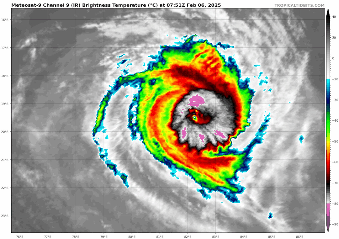
Vince keeps showing the eye.

0 likes
Visit the Caribbean-Central America Weather Thread where you can find at first post web cams,radars
and observations from Caribbean basin members Click Here
and observations from Caribbean basin members Click Here
-
cycloneye
- Admin
- Posts: 149710
- Age: 69
- Joined: Thu Oct 10, 2002 10:54 am
- Location: San Juan, Puerto Rico
Re: SIO: VINCE - Intense Tropical Cyclone
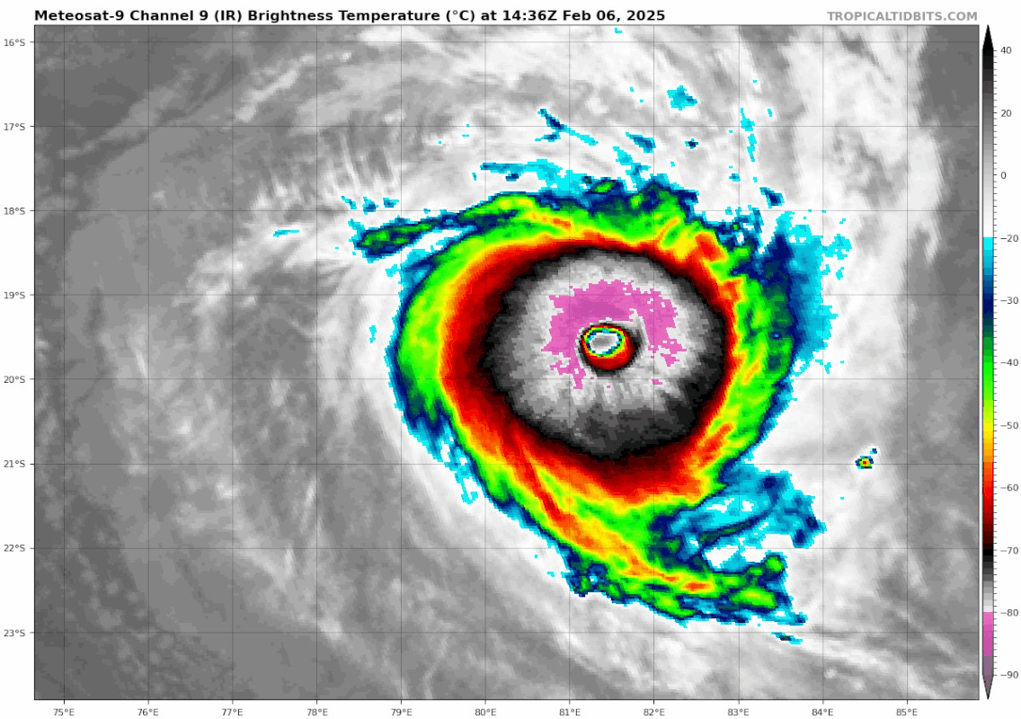
Intense category again by Meteo-France. JTWC has it at 110kt. Look at that pinhole eye.

INTENSE TROPICAL CYCLONE number 8
(VINCE)
Maximum winds (averaged over 10 minutes) estimated at sea: 165 km/h.
Estimated maximum gusts at sea: 230 km/h.
Estimated pressure at center: 960 hPa.
Position on February 5 at 4 p.m. local time: 18.7 South / 84.5 East.
Distance from the Reunion coast: 3000 km to the sector: EAST
Distance from Mayotte: 4250 km to the sector: EAST-SOUTH-EAST
Movement: WEST, at 19 km/h.
System Information:
- VINCE continued to experience good conditions throughout the day and may have intensified into an intense tropical cyclone. It is moving over the far eastern part of our basin far from any inhabited land.
- For the next 5 days, VINCE is expected to move in a west-southwest direction while remaining at the stage of an intense tropical cyclone, still far from inhabited land. Afterwards, it will take a more southwesterly direction while beginning to slowly weaken.
3 likes
Visit the Caribbean-Central America Weather Thread where you can find at first post web cams,radars
and observations from Caribbean basin members Click Here
and observations from Caribbean basin members Click Here
-
cycloneye
- Admin
- Posts: 149710
- Age: 69
- Joined: Thu Oct 10, 2002 10:54 am
- Location: San Juan, Puerto Rico
Re: SIO: VINCE - Intense Tropical Cyclone
INTENSE TROPICAL CYCLONE number 8
(VINCE)
Maximum winds (averaged over 10 minutes) estimated at sea: 165 km/h.
Estimated maximum gusts at sea: 230 km/h.
Estimated pressure at center: 960 hPa.
Position on February 6 at 04:00 local time: 19.0 South / 83.2 East.
Distance from the Reunion coast: 2865 km to the sector: EAST
Distance from Mayotte: 4120 km to the sector: EAST-SOUTH-EAST
Movement: WEST, at 15 km/h.
System Information:
- This morning, VINCE is still an intense tropical cyclone, evolving far to the east of the basin.
- Through the end of the week, VINCE is expected to move west-southwest while remaining at the stage of an intense tropical cyclone, away from inhabited land. Thereafter, it will turn southward and begin to weaken.
- It poses no threat to inhabited land.
0 likes
Visit the Caribbean-Central America Weather Thread where you can find at first post web cams,radars
and observations from Caribbean basin members Click Here
and observations from Caribbean basin members Click Here
-
WaveBreaking

- Category 2

- Posts: 728
- Joined: Sun Jun 30, 2024 11:33 am
- Location: US
Re: SIO: VINCE - Intense Tropical Cyclone

0 likes
I am NOT a professional meteorologist, so take all of my posts with a grain of salt. My opinions are mine and mine alone.
-
cycloneye
- Admin
- Posts: 149710
- Age: 69
- Joined: Thu Oct 10, 2002 10:54 am
- Location: San Juan, Puerto Rico
Re: SIO: VINCE - Intense Tropical Cyclone
System Information: INTENSE TROPICAL CYCLONE VINCE
Maximum winds (averaged over 10 minutes) estimated at sea: 165 km/h.
Estimated maximum gusts at sea: 230 km/h.
Estimated central pressure: 955 hPa.
Position on February 6 at 10 a.m. local time: 19.2 South / 82.4 East.
Distance from the Reunion coast: 2780 km to the sector: EAST
Distance from Mayotte: 4040 km to the sector: EAST-SOUTH-EAST
Movement: WEST-SOUTH-WEST, at 15 km/h.
Key messages:
- This morning, VINCE is still an intense tropical cyclone, evolving far to the east of the basin, nearly 2000km from Rodrigues.
- Through the end of the week, VINCE is expected to move west-southwest while remaining at the stage of an intense tropical cyclone, away from inhabited land. Thereafter, it will turn southward and begin to weaken.
- Impacts on Rodrigues: This system generates cyclonic swell and the sea state could become dangerous near the coasts Sunday evening and Monday morning.
0 likes
Visit the Caribbean-Central America Weather Thread where you can find at first post web cams,radars
and observations from Caribbean basin members Click Here
and observations from Caribbean basin members Click Here
-
cycloneye
- Admin
- Posts: 149710
- Age: 69
- Joined: Thu Oct 10, 2002 10:54 am
- Location: San Juan, Puerto Rico
Re: SIO: VINCE - Intense Tropical Cyclone
Impressive.

2 likes
Visit the Caribbean-Central America Weather Thread where you can find at first post web cams,radars
and observations from Caribbean basin members Click Here
and observations from Caribbean basin members Click Here
Re: SIO: VINCE - Intense Tropical Cyclone
TPXS12 PGTW 061455
A. TROPICAL CYCLONE 13S (VINCE)
B. 06/1430Z
C. 19.54S
D. 81.31E
E. TWO/MET9
F. T7.0/7.0/D1.0/24HRS STT: D0.5/03HRS
G. IR/EIR
H. REMARKS: 05A/PBO IRREG EYE/ANMTN. WMG EYE SURROUNDED BY W YIELDS
AN E# OF 6.0. ADDED 1.0 EYE ADJUSTMENT FOR CMG, TO YIELD A DT OF 7.0.
MET AND PT AGREE. DBO DT.
I. ADDITIONAL POSITIONS:
06/0937Z 19.42S 81.97E GPMI
06/1009Z 19.45S 81.77E SSMS
RAE
3 likes

Re: SIO: VINCE - Intense Tropical Cyclone
4 likes
TC naming lists: retirements and intensity
Most aggressive Advisory #1's in North Atlantic (cr. kevin for starting the list)
Most aggressive Advisory #1's in North Atlantic (cr. kevin for starting the list)
Re: SIO: VINCE - Intense Tropical Cyclone
1 likes
TC naming lists: retirements and intensity
Most aggressive Advisory #1's in North Atlantic (cr. kevin for starting the list)
Most aggressive Advisory #1's in North Atlantic (cr. kevin for starting the list)

Re: SIO: VINCE - Intense Tropical Cyclone
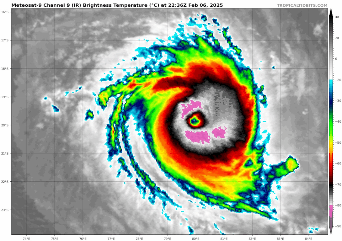
Vince is looking pretty on microwave. It looks like that band is just starting to close off and form an outer eyewall (M-PERC has a probability of ERC onset at about 0.8 based off this image)
VIIRS also got some great IR imagery:
 |  |
VIIRS also got some great IR imagery:
 |  |
2 likes
-
Hurricane2022

- Category 5

- Posts: 2092
- Joined: Tue Aug 23, 2022 11:38 pm
- Location: Araçatuba, Brazil
Re: SIO: VINCE - Intense Tropical Cyclone
Incredible!!!

4 likes
Sorry for the bad English sometimes...!
For reliable and detailed information for any meteorological phenomenon, please consult the National Hurricane Center, Joint Typhoon Warning Center , or your local Meteo Center.
--------
ECCE OMNIA NOVA FACIAM (Ap 21,5).
For reliable and detailed information for any meteorological phenomenon, please consult the National Hurricane Center, Joint Typhoon Warning Center , or your local Meteo Center.
--------
ECCE OMNIA NOVA FACIAM (Ap 21,5).
Re: SIO: VINCE - Intense Tropical Cyclone
1 likes
TC naming lists: retirements and intensity
Most aggressive Advisory #1's in North Atlantic (cr. kevin for starting the list)
Most aggressive Advisory #1's in North Atlantic (cr. kevin for starting the list)
Re: SIO: VINCE - Intense Tropical Cyclone
TPXS12 PGTW 070929
A. TROPICAL CYCLONE 13S (VINCE)
B. 07/0845Z
C. 19.84S
D. 77.66E
E. TWO/MET9
F. T7.0/7.0/D0.5/24HRS STT: D0.5/03HRS
G. IR/EIR/VIS/MSI
H. REMARKS: 03A/PBO EYE/ANMTN. WMG EYE SURROUNDED BY W YIELDS AN E#
OF 6.0. ADDED 1.0 EYE ADJUSTMENT FOR W, TO YIELD A DT OF 7.0. MET
YIELDS 7.5. PT YIELDS 7.0. DBO DT.
I. ADDITIONAL POSITIONS: NONE
NEVAREZ
0 likes

-
WaveBreaking
- Category 2
- Posts: 728
- Joined: Sun Jun 30, 2024 11:33 am
- Location: US
Re: SIO: VINCE - Intense Tropical Cyclone

0 likes
I am NOT a professional meteorologist, so take all of my posts with a grain of salt. My opinions are mine and mine alone.


-
cycloneye
- Admin
- Posts: 149710
- Age: 69
- Joined: Thu Oct 10, 2002 10:54 am
- Location: San Juan, Puerto Rico
Re: SIO: VINCE - Intense Tropical Cyclone
0 likes
Visit the Caribbean-Central America Weather Thread where you can find at first post web cams,radars
and observations from Caribbean basin members Click Here
and observations from Caribbean basin members Click Here
-
cycloneye
- Admin
- Posts: 149710
- Age: 69
- Joined: Thu Oct 10, 2002 10:54 am
- Location: San Juan, Puerto Rico
Re: SIO: VINCE - Intense Tropical Cyclone
System Information: VERY INTENSE TROPICAL CYCLONE VINCE
Maximum winds (averaged over 10 minutes) estimated at sea: 220 km/h.
Estimated maximum gusts at sea: 315 km/h.
Estimated pressure at center: 923 hPa.
Position on February 7 at 4 p.m. local time: 19.9 South / 77.0 East.
Distance from the Reunion coast: 2210 km to the sector: EAST
Distance from Mayotte: 3480 km to the sector: EAST-SOUTH-EAST
Movement: WEST, at 22 km/h.
Key messages:
- VINCE intensified to a very intense tropical cyclone (VICT) this Friday afternoon. This is a remarkably intense cyclone for a latitude close to 20°S in our basin. The center of the phenomenon is located nearly 1400 km east of Rodrigues.
- Until Sunday, VINCE is expected to remain at a high intensity, oscillating between an intense tropical cyclone (ITC) and a very intense tropical cyclone (VITC) while moving west to west-southwest. Between Sunday evening and Monday, while remaining more than 500 km east-southeast of Rodrigues, it is expected to make a turn towards the south while slowing down. It is then expected to continue to plunge towards southern latitudes early next week while gradually weakening, before losing its tropical characteristics around Wednesday over cooler waters.
- Although VINCE remains far from inhabited land, the cyclonic swell associated with the system is expected to generate dangerous seas on Rodrigues between Sunday and Monday morning. Residents are advised to monitor the evolution of the forecast through their national weather service.
0 likes
Visit the Caribbean-Central America Weather Thread where you can find at first post web cams,radars
and observations from Caribbean basin members Click Here
and observations from Caribbean basin members Click Here
-
Hurricane2022
- Category 5
- Posts: 2092
- Joined: Tue Aug 23, 2022 11:38 pm
- Location: Araçatuba, Brazil
Re: SIO: VINCE - Very Intense Tropical Cyclone
https://x.com/AnthonyDuarte03/status/1887882156527022283
https://x.com/zeb199818/status/1887751570487705899
https://x.com/zeb199818/status/1887751570487705899
0 likes
Sorry for the bad English sometimes...!
For reliable and detailed information for any meteorological phenomenon, please consult the National Hurricane Center, Joint Typhoon Warning Center , or your local Meteo Center.
--------
ECCE OMNIA NOVA FACIAM (Ap 21,5).
For reliable and detailed information for any meteorological phenomenon, please consult the National Hurricane Center, Joint Typhoon Warning Center , or your local Meteo Center.
--------
ECCE OMNIA NOVA FACIAM (Ap 21,5).
Who is online
Users browsing this forum: No registered users and 66 guests