(VIIRS imagery from NOAA's NOAA-21 Satellite, 0852z February 7, 2025.)
Top hurricane sat photos of all time...
Moderator: S2k Moderators
Forum rules

The posts in this forum are NOT official forecasts and should not be used as such. They are just the opinion of the poster and may or may not be backed by sound meteorological data. They are NOT endorsed by any professional institution or STORM2K. For official information, please refer to products from the National Hurricane Center and National Weather Service.
-
Hurricane2022

- Category 5

- Posts: 2088
- Joined: Tue Aug 23, 2022 11:38 pm
- Location: Araçatuba, Brazil
Re: Top hurricane sat photos of all time...
Very Intense Tropical Cyclone Vince

(VIIRS imagery from NOAA's NOAA-21 Satellite, 0852z February 7, 2025.)
(VIIRS imagery from NOAA's NOAA-21 Satellite, 0852z February 7, 2025.)
8 likes
Sorry for the bad English sometimes...!
For reliable and detailed information for any meteorological phenomenon, please consult the National Hurricane Center, Joint Typhoon Warning Center , or your local Meteo Center.
--------
ECCE OMNIA NOVA FACIAM (Ap 21,5).
For reliable and detailed information for any meteorological phenomenon, please consult the National Hurricane Center, Joint Typhoon Warning Center , or your local Meteo Center.
--------
ECCE OMNIA NOVA FACIAM (Ap 21,5).

Re: Top hurricane sat photos of all time...
1999 Odisha cyclone
The most intense cyclone recorded in the North Indian Ocean (912 mb IMD, 881 mb SSHWC/JTWC). I found these images by manually going through the mcfetch database. Not sure if I've seen imagery of the cyclone this clear on the internet before so I thought I'd post it. The imagery below is from MET-5 on October 28, 1999 at 18:00 UTC so at peak intensity.


The most intense cyclone recorded in the North Indian Ocean (912 mb IMD, 881 mb SSHWC/JTWC). I found these images by manually going through the mcfetch database. Not sure if I've seen imagery of the cyclone this clear on the internet before so I thought I'd post it. The imagery below is from MET-5 on October 28, 1999 at 18:00 UTC so at peak intensity.
7 likes
Re: Top hurricane sat photos of all time...
kevin wrote:1999 Odisha cyclone
The most intense cyclone recorded in the North Indian Ocean (912 mb IMD, 881 mb SSHWC/JTWC). I found these images by manually going through the mcfetch database. Not sure if I've seen imagery of the cyclone this clear on the internet before so I thought I'd post it. The imagery below is from MET-5 on October 28, 1999 at 18:00 UTC so at peak intensity.
https://i.imgur.com/HwCAwn8.png
https://i.imgur.com/Enj0bzb.png
https://i.imgur.com/K025wEs.png
I can't seem to find the color version of this image even though MET-5 should also have a color band. At least I can't download it right now through the database. I just ran a simple online colorizing tool on the image so you can get an idea what it might look like (see below).

3 likes
-
doomhaMwx

- Category 5
- Posts: 2493
- Age: 27
- Joined: Tue Apr 18, 2017 4:01 am
- Location: Baguio/Benguet, Philippines
- Contact:
Re: Top hurricane sat photos of all time...
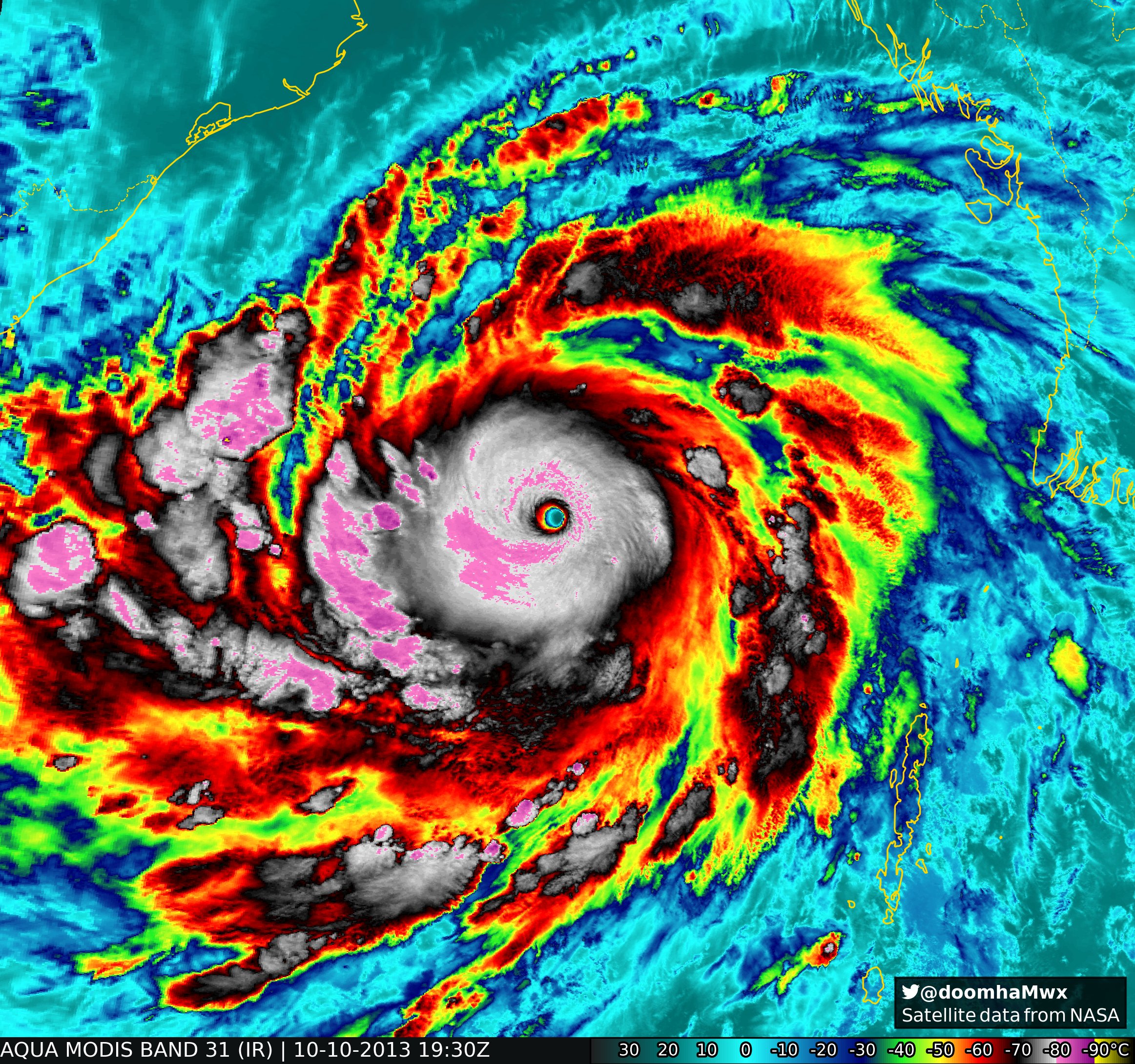
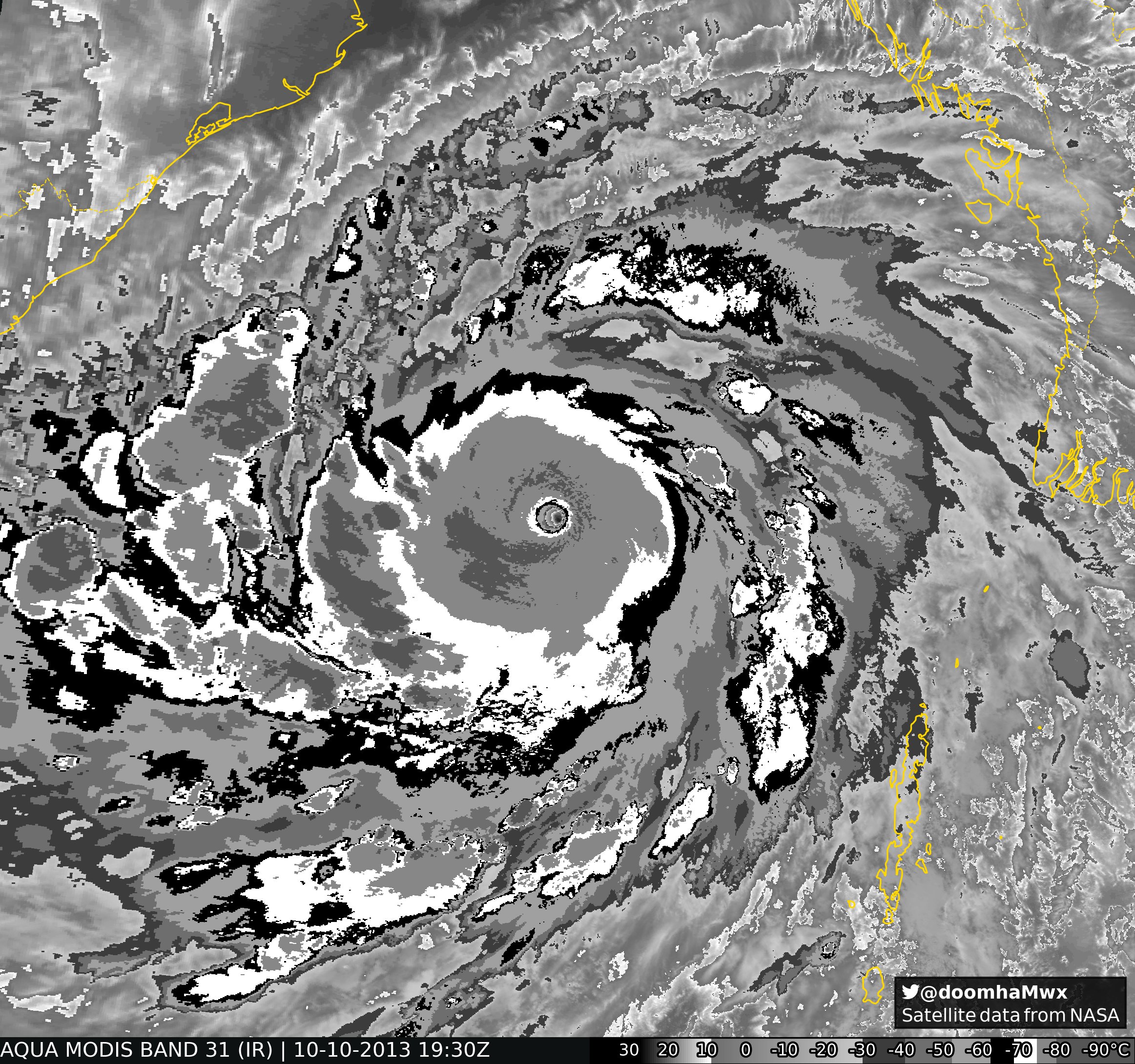
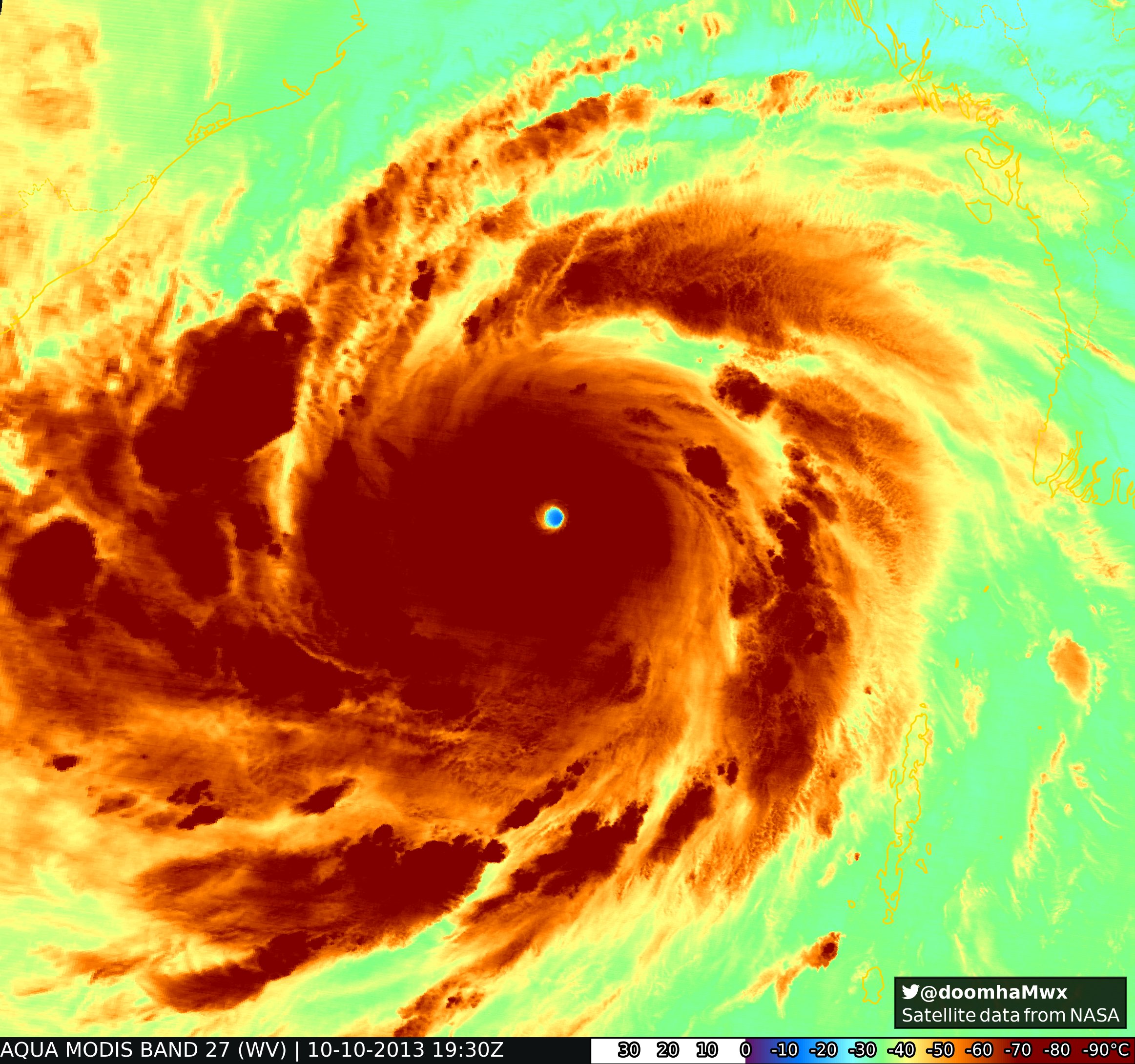
Cyclone Phailin (2013), likely more intense than the 1999 Odisha Cyclone. The MODIS pass below captured an incredibly warm and dry eye (IR and WV eye temp of 25C and -12.3C, respectively)!
https://x.com/doomhaMwx/status/1711895165202510268
https://x.com/doomhaMwx/status/1711895165202510268
5 likes
-
WaveBreaking

- Category 2

- Posts: 727
- Joined: Sun Jun 30, 2024 11:33 am
- Location: US
Re: Top hurricane sat photos of all time...
Monsoon trough breakdown in the SPAC causing a trio of cyclones (Alfred, INVEST/TD 96P, and Rae) and Cyclone Bianca off to the west.

3 likes
I am NOT a professional meteorologist, so take all of my posts with a grain of salt. My opinions are mine and mine alone.
-
Hurricane2022
- Category 5
- Posts: 2088
- Joined: Tue Aug 23, 2022 11:38 pm
- Location: Araçatuba, Brazil
Re: Top hurricane sat photos of all time...
It's not everyday that we can see 3 simultaneous cyclones in the tight Southwestern Pacific basin

1 likes
Sorry for the bad English sometimes...!
For reliable and detailed information for any meteorological phenomenon, please consult the National Hurricane Center, Joint Typhoon Warning Center , or your local Meteo Center.
--------
ECCE OMNIA NOVA FACIAM (Ap 21,5).
For reliable and detailed information for any meteorological phenomenon, please consult the National Hurricane Center, Joint Typhoon Warning Center , or your local Meteo Center.
--------
ECCE OMNIA NOVA FACIAM (Ap 21,5).
-
Hurricane2000
- Tropical Depression

- Posts: 57
- Joined: Sat Dec 28, 2024 4:50 pm

-
Category5Kaiju

- Category 5
- Posts: 4345
- Joined: Thu Dec 24, 2020 12:45 pm
- Location: Seattle during the summer, Phoenix during the winter
Re: Top hurricane sat photos of all time...

Some more Miltonmania
5 likes
Unless explicitly stated, all information in my posts is based on my own opinions and observations. Tropical storms and hurricanes can be extremely dangerous. Refer to an accredited weather research agency or meteorologist if you need to make serious decisions regarding an approaching storm.
-
WaveBreaking
- Category 2
- Posts: 727
- Joined: Sun Jun 30, 2024 11:33 am
- Location: US
Re: Top hurricane sat photos of all time...
Even though most subtropical/hybrid cyclones are not the most picturesque looking, here are a couple that I think are pretty nice looking.
Unnamed Subtropical Storm (2023)

Subtropical Storm Omeka (2010)

INVEST/Storm 91C (2006)

Unnamed Subtropical Storm (2023)
Subtropical Storm Omeka (2010)
INVEST/Storm 91C (2006)
3 likes
I am NOT a professional meteorologist, so take all of my posts with a grain of salt. My opinions are mine and mine alone.
-
Hurricane2000
- Tropical Depression
- Posts: 57
- Joined: Sat Dec 28, 2024 4:50 pm
Re: Top hurricane sat photos of all time...
WaveBreaking wrote:Even though most subtropical/hybrid cyclones are not the most picturesque looking, here are a couple that I think are pretty nice looking.
Unnamed Subtropical Storm (2023)
https://i.imgur.com/5LA2kAk.jpeg
Subtropical Storm Omeka (2010)
https://i.imgur.com/ByqL4EU.jpeg
INVEST/Storm 91C (2006)
https://i.imgur.com/Xt1ZOpw.jpeg
Wow! Omeka looks very interesting!
1 likes
Weather = Cool 
-
Hurricane2000
- Tropical Depression
- Posts: 57
- Joined: Sat Dec 28, 2024 4:50 pm
Re: Top hurricane sat photos of all time...
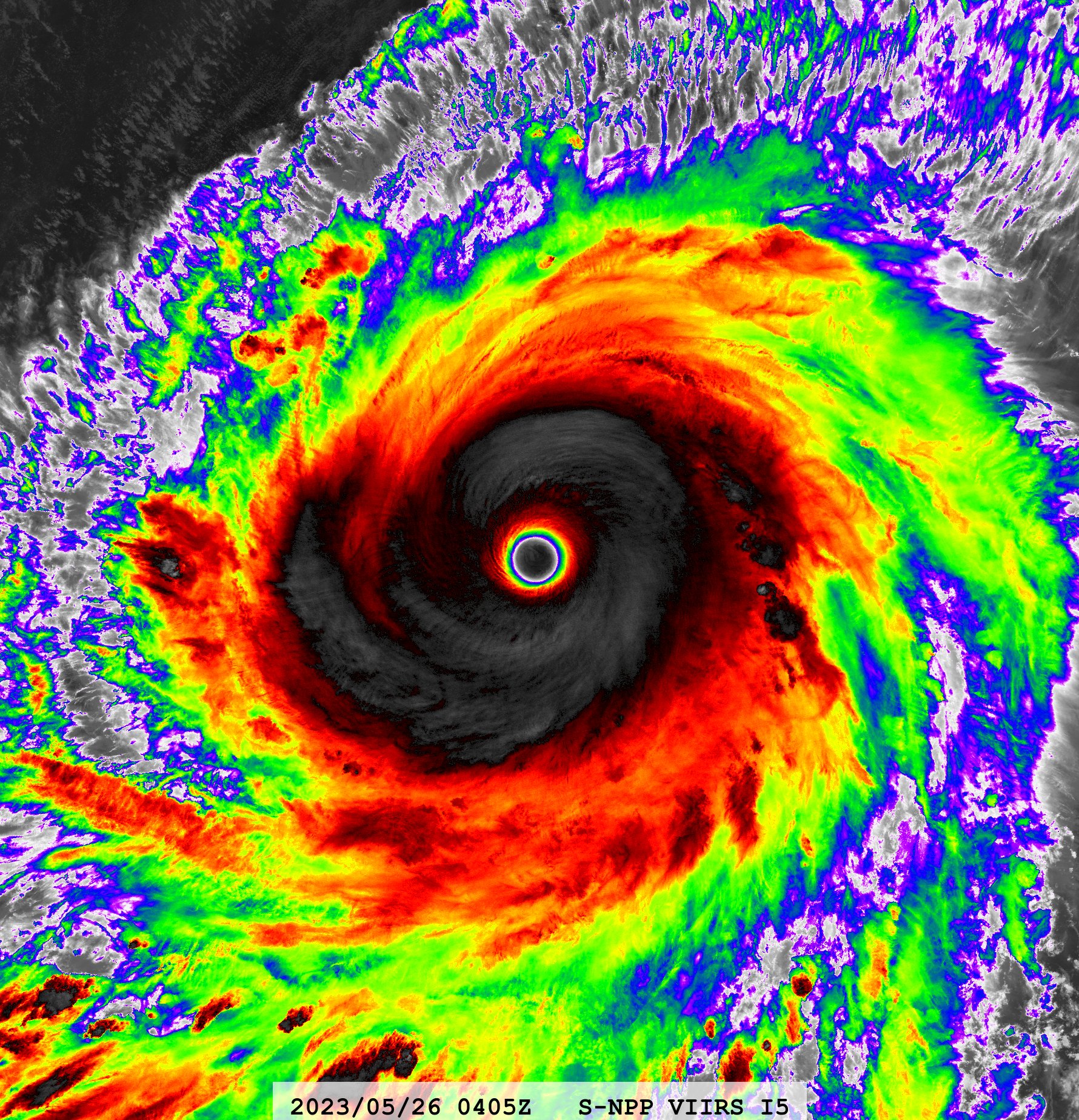
One of my favorite images ever, Typhoon Mawar of 2023
5 likes
Weather = Cool
-
cycloneye

- Admin

- Posts: 149681
- Age: 69
- Joined: Thu Oct 10, 2002 10:54 am
- Location: San Juan, Puerto Rico
Re: Top hurricane sat photos of all time...
One of the strongest of all time, Patricia on October 2015.

2 likes
Visit the Caribbean-Central America Weather Thread where you can find at first post web cams,radars
and observations from Caribbean basin members Click Here
and observations from Caribbean basin members Click Here

-
Hurricane2000
- Tropical Depression
- Posts: 57
- Joined: Sat Dec 28, 2024 4:50 pm
Re: Top hurricane sat photos of all time...
Anyone got any good pictures of Hurricane Juliette 2001? Its structure at peak was crazy 
1 likes
Weather = Cool

Re: Top hurricane sat photos of all time...
Hurricane2000 wrote:Anyone got any good pictures of Hurricane Juliette 2001? Its structure at peak was crazy
It's not quite at peak, but here's Juliette with three concentric eyewalls:
 |  |
Brian McNoldy has a good satellite loop of that here.
2 likes
-
Hurricane2000
- Tropical Depression
- Posts: 57
- Joined: Sat Dec 28, 2024 4:50 pm
Re: Top hurricane sat photos of all time...
Hurricane Carmen 1974
With this kind of structure I wonder how strong it really was...

With this kind of structure I wonder how strong it really was...
1 likes
Weather = Cool
-
WaveBreaking
- Category 2
- Posts: 727
- Joined: Sun Jun 30, 2024 11:33 am
- Location: US
Re: Top hurricane sat photos of all time...
Hurricane Erick (2025)


3 likes
I am NOT a professional meteorologist, so take all of my posts with a grain of salt. My opinions are mine and mine alone.
-
Category5Kaiju
- Category 5
- Posts: 4345
- Joined: Thu Dec 24, 2020 12:45 pm
- Location: Seattle during the summer, Phoenix during the winter
Re: Top hurricane sat photos of all time...
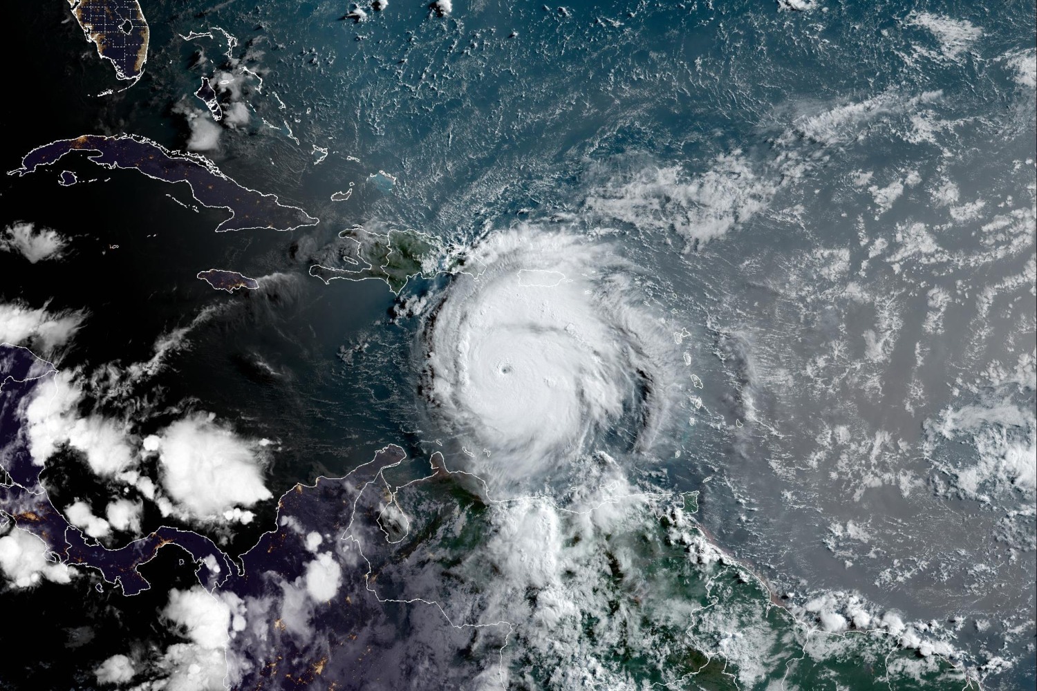
One year ago....an anomalous monster was born in the Atlantic Ocean.
5 likes
Unless explicitly stated, all information in my posts is based on my own opinions and observations. Tropical storms and hurricanes can be extremely dangerous. Refer to an accredited weather research agency or meteorologist if you need to make serious decisions regarding an approaching storm.
-
Hurricane2000
- Tropical Depression
- Posts: 57
- Joined: Sat Dec 28, 2024 4:50 pm
Re: Top hurricane sat photos of all time...
Hurricane Patricia 2015 from the Suomi-NPP Day/Night Band
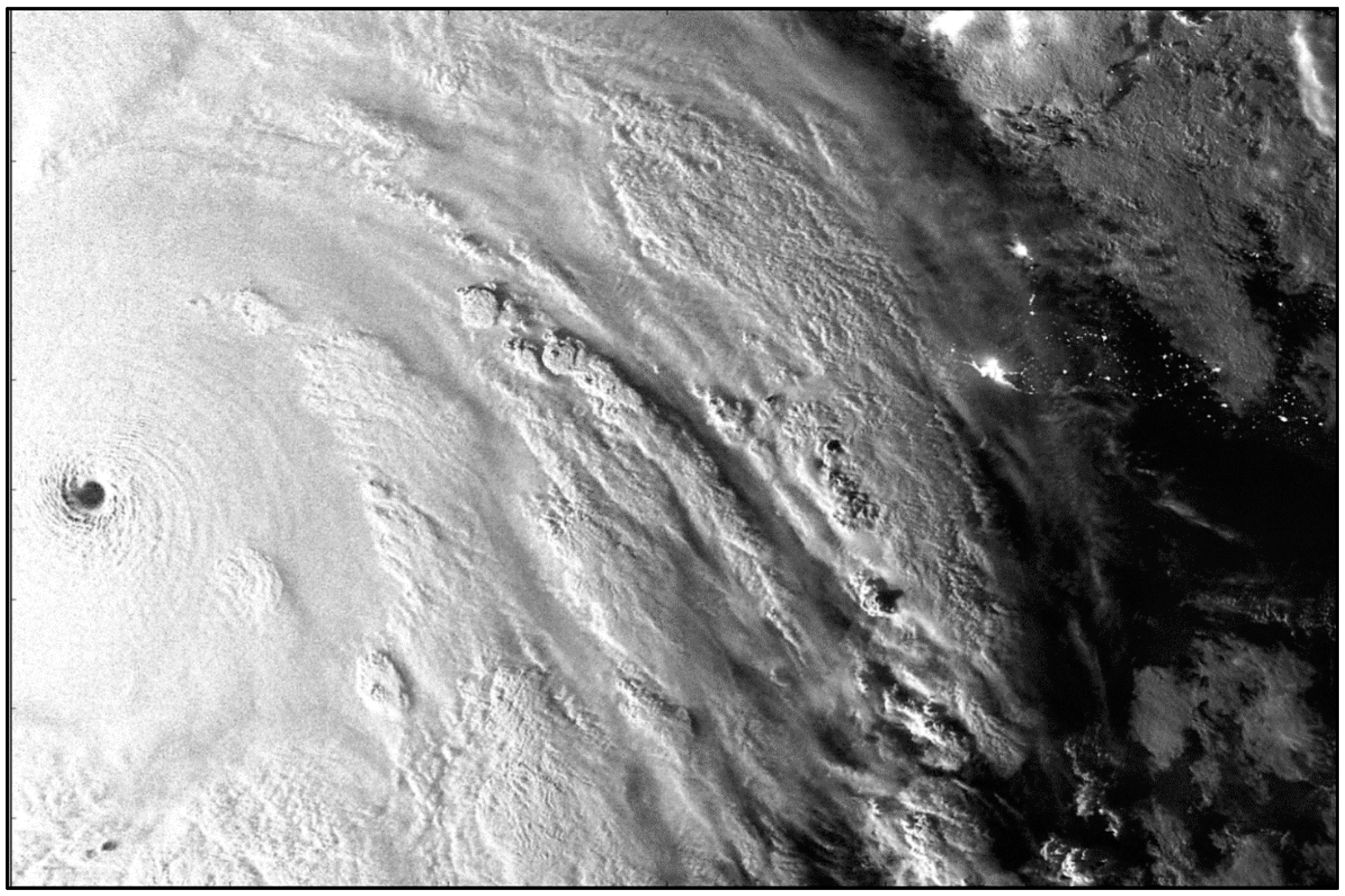
Simply breathtaking
Simply breathtaking
6 likes
Weather = Cool
-
cycloneye
- Admin
- Posts: 149681
- Age: 69
- Joined: Thu Oct 10, 2002 10:54 am
- Location: San Juan, Puerto Rico
Re: Top hurricane sat photos of all time...
Powerful Hurricane Teddy in 2020.

6 likes
Visit the Caribbean-Central America Weather Thread where you can find at first post web cams,radars
and observations from Caribbean basin members Click Here
and observations from Caribbean basin members Click Here
Who is online
Users browsing this forum: No registered users and 200 guests