
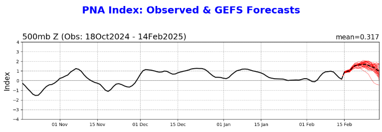
Iceresistance wrote:The PNA is confusing the models right now as it is actively defying forecasts
https://s3.gifyu.com/images/bSbls.png
https://s3.gifyu.com/images/bSbls.png
Probably why the GFS isn’t handling things well.
Moderator: S2k Moderators
 The posts in this forum are NOT official forecast and should not be used as such. They are just the opinion of the poster and may or may not be backed by sound meteorological data. They are NOT endorsed by any professional institution or STORM2K.
Iceresistance wrote:The PNA is confusing the models right now as it is actively defying forecasts
https://s3.gifyu.com/images/bSbls.png
https://s3.gifyu.com/images/bSbls.png
Brent wrote:Noticed not everyone is buying the hype here.. watched a different TV met in OKC earlier and he was showing only an inch or two of snow pretty much which would be more like Christmas 22 and January last year where the cold is more the story
Long way to go still. I will say TWC hasn't budged off 4-6 inches
Also in the short term tomorrow night has a very quick window for a dusting to an inch.... Well see if we can overperform again(we've yet to underperform this winter...)

Gotwood wrote:Brent wrote:Noticed not everyone is buying the hype here.. watched a different TV met in OKC earlier and he was showing only an inch or two of snow pretty much which would be more like Christmas 22 and January last year where the cold is more the story
Long way to go still. I will say TWC hasn't budged off 4-6 inches
Also in the short term tomorrow night has a very quick window for a dusting to an inch.... Well see if we can overperform again(we've yet to underperform this winter...)
TWC had me getting 8-12 inches of snow just two days prior to me getting a half inch lol.
Brent wrote:Gotwood wrote:Brent wrote:Noticed not everyone is buying the hype here.. watched a different TV met in OKC earlier and he was showing only an inch or two of snow pretty much which would be more like Christmas 22 and January last year where the cold is more the story
Long way to go still. I will say TWC hasn't budged off 4-6 inches
Also in the short term tomorrow night has a very quick window for a dusting to an inch.... Well see if we can overperform again(we've yet to underperform this winter...)
TWC had me getting 8-12 inches of snow just two days prior to me getting a half inch lol.
Yup and I still remember January last year... 3 days before two different mets on the radio saying 10 inches possible
We struggled to get an inch
So yeah there's gonna part of me that remains skeptical about a big snowstorm. I don't trust it when arctic air is flooding i
Gotwood wrote:Brent wrote:Gotwood wrote:TWC had me getting 8-12 inches of snow just two days prior to me getting a half inch lol.
Yup and I still remember January last year... 3 days before two different mets on the radio saying 10 inches possible
We struggled to get an inch
So yeah there's gonna part of me that remains skeptical about a big snowstorm. I don't trust it when arctic air is flooding i
We are at that point in the season for my area that I would take 2 inches like it was a foot lol. I just don’t want another dry cold give me something nice to look at while I’m freezing.


wxman57 wrote:I won't need my pilot, my walls are fine. A third wall has been completed between Waco and Lufkin. You an keep the cold air up in D-FW. Just mid to upper 20s for Houston Thursday morning (25-29). I think the NWS is paying too much attention to the Euro, which was way too cold for Houston with the last couple of events. My azaleas are still blooming - they laugh at this front! It's 70 degrees this morning.
https://wxman57.com/images/HOU00ZFeb15.jpg
https://wxman57.com/images/HOU00ZFeb15.jpg
https://wxman57.com/images/DFW00ZFeb15.jpg
https://wxman57.com/images/DFW00ZFeb15.jpg
orangeblood wrote:Latest model guidance finally starting to converge on a more north solution of the s/w. TPV ended up too strong for the further south scenario. Oklahoma and Kansas big winners again with this system
Regarding the extended 6-7 day range: Euro and CMC looks like they did a good job handling the temperature profiles but got the 5h wrong. GFS did bad with temps but good with the 5h setup and subsequent QPF output. Also Euro AI was great with the 5h pattern but took awhile on temps similar to GFS
jasons2k wrote:Well, I posted this in the wrong thread. It was at the top in Tapatalk. Anyway - here is my original post with Mr WxMan's reply:
"Looks like WxMan57’s wall has failed. He needs to wake his pilot up.
NWS here, within 5 days now…
Wednesday Night
Mostly clear, with a low around 20."wxman57 wrote:I won't need my pilot, my walls are fine. A third wall has been completed between Waco and Lufkin. You an keep the cold air up in D-FW. Just mid to upper 20s for Houston Thursday morning (25-29). I think the NWS is paying too much attention to the Euro, which was way too cold for Houston with the last couple of events. My azaleas are still blooming - they laugh at this front! It's 70 degrees this morning.
https://wxman57.com/images/HOU00ZFeb15.jpg
https://wxman57.com/images/HOU00ZFeb15.jpg
https://wxman57.com/images/DFW00ZFeb15.jpg
https://wxman57.com/images/DFW00ZFeb15.jpg
Gotwood wrote:orangeblood wrote:Latest model guidance finally starting to converge on a more north solution of the s/w. TPV ended up too strong for the further south scenario. Oklahoma and Kansas big winners again with this system
Regarding the extended 6-7 day range: Euro and CMC looks like they did a good job handling the temperature profiles but got the 5h wrong. GFS did bad with temps but good with the 5h setup and subsequent QPF output. Also Euro AI was great with the 5h pattern but took awhile on temps similar to GFS
Is there no hope for change or are we pretty much locked in to another dry slot?


orangeblood wrote:Gotwood wrote:orangeblood wrote:Latest model guidance finally starting to converge on a more north solution of the s/w. TPV ended up too strong for the further south scenario. Oklahoma and Kansas big winners again with this system
Regarding the extended 6-7 day range: Euro and CMC looks like they did a good job handling the temperature profiles but got the 5h wrong. GFS did bad with temps but good with the 5h setup and subsequent QPF output. Also Euro AI was great with the 5h pattern but took awhile on temps similar to GFS
Is there no hope for change or are we pretty much locked in to another dry slot?
Unfortunately another dry slot seems highly likely. Just wasn’t our winter for winter precip, cold was there the systems weren’t
Portastorm wrote:orangeblood wrote:Gotwood wrote:Is there no hope for change or are we pretty much locked in to another dry slot?
Unfortunately another dry slot seems highly likely. Just wasn’t our winter for winter precip, cold was there the systems weren’t
I know I speak for most of this group when I say “dry cold sucks.” I’d rather have warmth and storms if we’re not going to get any wintry precip at this rate. Bring on spring.


wxman57 wrote:12Z models are not as cold for TX as previous days. My walls are definitely having an impact. Even the Canadian has warmed considerably, with a low of 33 here Thursday and only 29 on Friday. National Blend of Models has a coldest of 30 on Thursday. Hardly a historic event for us. Meanwhile, it's 77 in SW Houston. Time for a bike ride!
MAWA!!


orangeblood wrote:wxman57 wrote:12Z models are not as cold for TX as previous days. My walls are definitely having an impact. Even the Canadian has warmed considerably, with a low of 33 here Thursday and only 29 on Friday. National Blend of Models has a coldest of 30 on Thursday. Hardly a historic event for us. Meanwhile, it's 77 in SW Houston. Time for a bike ride!
MAWA!!
You may have a tiny wall around Houston but most of the state is setting records
Users browsing this forum: No registered users and 86 guests