2025 ENSO Updates

This is the general tropical discussion area. Anyone can take their shot at predicting a storms path.

Moderator: S2k Moderators

Forum rules

The posts in this forum are NOT official forecasts and should not be used as such. They are just the opinion of the poster and may or may not be backed by sound meteorological data. They are NOT endorsed by any professional institution or STORM2K. For official information, please refer to products from the National Hurricane Center and National Weather Service.

Help Support Storm2K
Message
Author
LarryWx
Category 5
Category 5
Posts: 6246
Joined: Sun Sep 07, 2003 2:04 pm
Location: GA

Re: 2025 ENSO Updates

#81 Postby LarryWx » Mon Mar 10, 2025 10:41 am

Ntxw wrote:
LarryWx wrote:26FEB2025 27.5 1.1 27.0 0.3 26.7-0.2 27.5-0.6
05MAR2025 28.1 1.6 27.4 0.5 27.0 0.0 27.8-0.3

 So, the latest week being reported (last calendar week) shows all regions warmed with Nino 3.4 up to 0.0 and Nino 1+2 up to a whopping +1.6. But keep in mind that these aren’t taking into account the relatively warm surrounding tropical/global waters like RONI does. So, one may want to subtract ~0.5 to 0.6 to get a better picture of the situation. Regardless, the trends have been clearly warmer and Nino 1+2, itself, would still be in moderate Nino territory and Nino 3 would be up to neutral.

https://www.cpc.ncep.noaa.gov/data/indi ... st9120.for


Question for you Larry, if the RONI is the superior index, how would you grade this past winter noting was showing a better La Nina than ONI based off the PAC teleconnections? My initial guess is that the +PNA and North Pacific Aleutian trough gave some questions as to how reliable it is. Should we not have seen a more robust -PNA/Aleutian ridge combo per RONI?

https://i.imgur.com/gIw6C2N.gif


Great Q!

1) Indeed, in a typical solid La Niña (though not in nearly all of them of course), I agree that we would have seen a somewhat dominant -PNA/Aleutian ridge.

2) Instead we had the opposite. The seasonal models’ forecasts made several months out were largely clueless about this.

3) Interestingly, the seasonal models were also clueless about the El Niño of 2023-4 with their understandable forecast for a typical of El Niño dominant +PNA/Aleutian trough. What they forecasted for 2023-4 consistent with the actual El Niño actually occurred during the 2024-5 negative neutral to unofficial La Niña (if you go by RONI)!

4) So, the last two winters have been bizarre in relation to typical ENSO.

5) This just goes to show that ENSO, itself, is not always the dominant seasonal factor.

6) Sort of related, I’m not concluding from 2024-5, alone, that RONI is inferior to ONI when it comes to which should be used more to try to make a seasonal forecast whether winter or tropical. There are always exceptions. Also, keep in mind that even cold neutral (which is official per ONI for 2024-5) doesn’t itself favor a dominant +PNA/Aleutian trough.

7) Thus I expect to continue emphasizing the importance of being aware of RONI but also keeping in mind that ENSO isn’t always the main factor. To me the concept makes a lot of sense.

Edit: On average as I posted about several times and was shown by another poster (“US Tropics”??) in graphical form, ENSO fall/winters peaking as weak La Niña had been the most dangerous ENSO as regards the hurricane season (worse than fall/winter peaking as either strong La Nina or cold neutral) for the corridor from the Lesser Antilles through Puerto Rico, the Bahamas, FL, and the SE US coast. Well, it ended up a terrible season in those areas overall. That, alone doesn't of course prove RONI is a better indicator but it certainly was more in line than ONI in that regard.
3 likes   
Personal Forecast Disclaimer:
The posts in this forum are NOT official forecasts and should not be used as such. They are just the opinion of the poster and may or may not be backed by sound meteorological data. They are NOT endorsed by any professional institution or storm2k.org. For official information, please refer to the NHC and NWS products.

User avatar
Kingarabian
S2K Supporter
S2K Supporter
Posts: 15827
Joined: Sat Aug 08, 2009 3:06 am
Location: Honolulu, Hawaii

Re: 2025 ENSO Updates

#82 Postby Kingarabian » Tue Mar 11, 2025 12:00 pm

NOAAs monthly PDO index had it cooling a bit from -0.75 to -0.85.
0 likes   
RIP Kobe Bryant

User avatar
cycloneye
Admin
Admin
Posts: 143858
Age: 68
Joined: Thu Oct 10, 2002 10:54 am
Location: San Juan, Puerto Rico

Re: 2025 ENSO Updates

#83 Postby cycloneye » Tue Mar 11, 2025 7:26 pm

@cyclonicwx
Seems like the cold pool under the eastern/central Pacific has weakened in the past couple of weeks. Seems the persistent EPAC WWB may be to blame thanks to the downwelling it causes. Less efficient this far east but with its persistence it can have some effectiveness


 https://x.com/cyclonicwx/status/1899604048287784994


0 likes   
Visit the Caribbean-Central America Weather Thread where you can find at first post web cams,radars
and observations from Caribbean basin members Click Here

User avatar
cycloneye
Admin
Admin
Posts: 143858
Age: 68
Joined: Thu Oct 10, 2002 10:54 am
Location: San Juan, Puerto Rico

Re: 2025 ENSO Updates

#84 Postby cycloneye » Wed Mar 12, 2025 6:21 am

2 likes   
Visit the Caribbean-Central America Weather Thread where you can find at first post web cams,radars
and observations from Caribbean basin members Click Here

User avatar
Kingarabian
S2K Supporter
S2K Supporter
Posts: 15827
Joined: Sat Aug 08, 2009 3:06 am
Location: Honolulu, Hawaii

Re: 2025 ENSO Updates

#85 Postby Kingarabian » Wed Mar 12, 2025 12:14 pm

2017 is almost a perfect ENSO analog. Been that way since January.
2 likes   
RIP Kobe Bryant

User avatar
cycloneye
Admin
Admin
Posts: 143858
Age: 68
Joined: Thu Oct 10, 2002 10:54 am
Location: San Juan, Puerto Rico

Re: 2025 ENSO Updates: CPC March update= 62% of Neutral from April thru August

#86 Postby cycloneye » Thu Mar 13, 2025 9:07 am

CPC march update has la niña ending by april and they have 62% of neutral thru august.

https://www.cpc.ncep.noaa.gov/products/ ... disc.shtml

Image
0 likes   
Visit the Caribbean-Central America Weather Thread where you can find at first post web cams,radars
and observations from Caribbean basin members Click Here

User avatar
cycloneye
Admin
Admin
Posts: 143858
Age: 68
Joined: Thu Oct 10, 2002 10:54 am
Location: San Juan, Puerto Rico

Re: 2025 ENSO Updates: CPC March update= 62% of Neutral from April thru August

#87 Postby cycloneye » Thu Mar 13, 2025 9:42 am

Here is the ENSO Blog with the details of the march update.

Larrywx, they mentioned the RONI.

https://www.climate.gov/news-features/b ... ected-soon

https://www.cpc.ncep.noaa.gov/data/indi ... .ascii.txt
3 likes   
Visit the Caribbean-Central America Weather Thread where you can find at first post web cams,radars
and observations from Caribbean basin members Click Here

User avatar
cycloneye
Admin
Admin
Posts: 143858
Age: 68
Joined: Thu Oct 10, 2002 10:54 am
Location: San Juan, Puerto Rico

Re: 2025 ENSO Updates: CPC weekly update of 3/17/25=Niño 3.4 warms up to -0.3C / First time above 0.0C since July 2024

#88 Postby cycloneye » Mon Mar 17, 2025 8:28 am

CPC 3/17/25 update has niño 3.4 going up to -0.3C (Warm Neutral) from the 0.0 of last week's update. Is the first time since July 2024 that 3.4 goes above 0.0C.

https://www.cpc.ncep.noaa.gov/products/ ... ts-web.pdf

Image

Image
1 likes   
Visit the Caribbean-Central America Weather Thread where you can find at first post web cams,radars
and observations from Caribbean basin members Click Here

LarryWx
Category 5
Category 5
Posts: 6246
Joined: Sun Sep 07, 2003 2:04 pm
Location: GA

Re: 2025 ENSO Updates: CPC weekly update of 3/17/25=Niño 3.4 warms up to -0.3C / First time above 0.0C since July 2024

#89 Postby LarryWx » Mon Mar 17, 2025 10:35 am

cycloneye wrote:CPC 3/17/25 update has niño 3.4 going up to -0.3C (Warm Neutral) from the 0.0 of last week's update. Is the first time since July 2024 that 3.4 goes above 0.0C.

https://www.cpc.ncep.noaa.gov/products/ ... ts-web.pdf

https://i.imgur.com/SDb17N6.jpeg

https://i.imgur.com/6RlsxB8.jpeg


Thank you, Luis! Today’s release of the weekly Nino 3.4 SSTa, which is for the last week (centered on March 12th), came in at +0.3C. (I know that’s what you meant because you said it came in above 0.0 and is warm neutral, but you have a typo saying -0.3C.) The reason I’m posting is that over the prior 6 weeks from the week centered on Jan 29th (when it was -0.8C), it has warmed a whopping 1.1C. This is by far the strongest warming for that particular 6 week period on record (records back to 1982). The next fastest warming is only half that (~+0.55C) set in both 2023 and 2011!

https://www.cpc.ncep.noaa.gov/data/indi ... st9120.for
2 likes   
Personal Forecast Disclaimer:
The posts in this forum are NOT official forecasts and should not be used as such. They are just the opinion of the poster and may or may not be backed by sound meteorological data. They are NOT endorsed by any professional institution or storm2k.org. For official information, please refer to the NHC and NWS products.

User avatar
cycloneye
Admin
Admin
Posts: 143858
Age: 68
Joined: Thu Oct 10, 2002 10:54 am
Location: San Juan, Puerto Rico

Re: 2025 ENSO Updates: CPC weekly update of 3/17/25=Niño 3.4 warms up to -0.3C / First time above 0.0C since July 2024

#90 Postby cycloneye » Mon Mar 17, 2025 10:52 am

LarryWx wrote:
cycloneye wrote:CPC 3/17/25 update has niño 3.4 going up to +0.3C (Warm Neutral) from the 0.0 of last week's update. Is the first time since July 2024 that 3.4 goes above 0.0C.

https://www.cpc.ncep.noaa.gov/products/ ... ts-web.pdf

https://i.imgur.com/SDb17N6.jpeg

https://i.imgur.com/6RlsxB8.jpeg


Thank you, Luis! Today’s release of the weekly Nino 3.4 SSTa, which is for the last week (centered on March 12th), came in at +0.3C. (I know that’s what you meant because you said it came in above 0.0 and is warm neutral, but you have a typo saying -0.3C.) The reason I’m posting is that over the prior 6 weeks from the week centered on Jan 29th (when it was -0.8C), it has warmed a whopping 1.1C. This is by far the strongest warming for that particular 6 week period on record (records back to 1982). The next fastest warming is only half that (~+0.55C) set in both 2023 and 2011!

https://www.cpc.ncep.noaa.gov/data/indi ... st9120.for
0 likes   
Visit the Caribbean-Central America Weather Thread where you can find at first post web cams,radars
and observations from Caribbean basin members Click Here

User avatar
cycloneye
Admin
Admin
Posts: 143858
Age: 68
Joined: Thu Oct 10, 2002 10:54 am
Location: San Juan, Puerto Rico

Re: 2025 ENSO Updates: CPC weekly update of 3/17/25=Niño 3.4 warms up to +0.3C / First time above 0.0C since July 2024

#91 Postby cycloneye » Mon Mar 17, 2025 10:52 am

cycloneye wrote:
LarryWx wrote:
cycloneye wrote:CPC 3/17/25 update has niño 3.4 going up to +0.3C (Warm Neutral) from the 0.0 of last week's update. Is the first time since July 2024 that 3.4 goes above 0.0C.

https://www.cpc.ncep.noaa.gov/products/ ... ts-web.pdf

https://i.imgur.com/SDb17N6.jpeg

https://i.imgur.com/6RlsxB8.jpeg


Thank you, Luis! Today’s release of the weekly Nino 3.4 SSTa, which is for the last week (centered on March 12th), came in at +0.3C. (I know that’s what you meant because you said it came in above 0.0 and is warm neutral, but you have a typo saying -0.3C.) The reason I’m posting is that over the prior 6 weeks from the week centered on Jan 29th (when it was -0.8C), it has warmed a whopping 1.1C. This is by far the strongest warming for that particular 6 week period on record (records back to 1982). The next fastest warming is only half that (~+0.55C) set in both 2023 and 2011!

https://www.cpc.ncep.noaa.gov/data/indi ... st9120.for


Oh yes, fixed it, Thanks LarryWx.
1 likes   
Visit the Caribbean-Central America Weather Thread where you can find at first post web cams,radars
and observations from Caribbean basin members Click Here

TomballEd
Category 2
Category 2
Posts: 575
Age: 61
Joined: Wed Aug 16, 2023 4:52 pm
Location: Spring/Klein area, not Tomball

Re: 2025 ENSO Updates

#92 Postby TomballEd » Mon Mar 17, 2025 11:27 am

Kingarabian wrote:2017 is almost a perfect ENSO analog. Been that way since January.


Just based on a Southern Plains drought and an active severe season in the SEUSA, this feels like 2011. We're not coming off a strong cool ENSO like 2010-2011 toward neutral, but we are going, based on forecasts like from IRI, from a weak cool ENSO into neutral.

2011 had an active hurricane season but limited/weak Gulf activity.
1 likes   

User avatar
cycloneye
Admin
Admin
Posts: 143858
Age: 68
Joined: Thu Oct 10, 2002 10:54 am
Location: San Juan, Puerto Rico

Re: 2025 ENSO Updates

#93 Postby cycloneye » Wed Mar 19, 2025 9:40 am

Niño 3.4 going down fast. Graphics from Tropical Tidbits, Coral Reef and Oisst.

Image

Image

Image
0 likes   
Visit the Caribbean-Central America Weather Thread where you can find at first post web cams,radars
and observations from Caribbean basin members Click Here

User avatar
cycloneye
Admin
Admin
Posts: 143858
Age: 68
Joined: Thu Oct 10, 2002 10:54 am
Location: San Juan, Puerto Rico

Re: 2025 ENSO Updates

#94 Postby cycloneye » Thu Mar 20, 2025 12:38 pm

The march update of the ENSO models that came out today are on a consensus for neutral thru the peak months ASO.

Image
0 likes   
Visit the Caribbean-Central America Weather Thread where you can find at first post web cams,radars
and observations from Caribbean basin members Click Here

User avatar
cycloneye
Admin
Admin
Posts: 143858
Age: 68
Joined: Thu Oct 10, 2002 10:54 am
Location: San Juan, Puerto Rico

2025 Indicators: SST's, MSLP, Shear, SAL, Steering, Instability (Day 16+ Climate Models)

#95 Postby cycloneye » Fri Mar 21, 2025 9:32 am

Andy Hazelton throws to the mix 2008 as analog.

@AndyHazelton
Really interesting how pronounced the "El Niño Costero" event over the Eastern Pacific has been recently, with reduced trades over the last few months and growing +SST anomalies. The upcoming pattern looks like it will reinforce things for a while, as well. Curious if this manages to last into hurricane season like the 2008 event?


 https://x.com/AndyHazelton/status/1903076678152171599


0 likes   
Visit the Caribbean-Central America Weather Thread where you can find at first post web cams,radars
and observations from Caribbean basin members Click Here

TomballEd
Category 2
Category 2
Posts: 575
Age: 61
Joined: Wed Aug 16, 2023 4:52 pm
Location: Spring/Klein area, not Tomball

Re: 2025 Indicators: SST's, MSLP, Shear, SAL, Steering, Instability (Day 16+ Climate Models)

#96 Postby TomballEd » Fri Mar 21, 2025 10:55 am

cycloneye wrote:Andy Hazelton throws to the mix 2008 as analog.

@AndyHazelton
Really interesting how pronounced the "El Niño Costero" event over the Eastern Pacific has been recently, with reduced trades over the last few months and growing +SST anomalies. The upcoming pattern looks like it will reinforce things for a while, as well. Curious if this manages to last into hurricane season like the 2008 event?


 https://x.com/AndyHazelton/status/1903076678152171599


2008 had two hurricane landfalls in Texas, where I live. People mentioning 2017 makes me nervous as well. Bad year locally and in the Caribbean.
0 likes   

User avatar
Kingarabian
S2K Supporter
S2K Supporter
Posts: 15827
Joined: Sat Aug 08, 2009 3:06 am
Location: Honolulu, Hawaii

Re: 2025 Indicators: SST's, MSLP, Shear, SAL, Steering, Instability (Day 16+ Climate Models)

#97 Postby Kingarabian » Fri Mar 21, 2025 2:14 pm

cycloneye wrote:Andy Hazelton throws to the mix 2008 as analog.

@AndyHazelton
Really interesting how pronounced the "El Niño Costero" event over the Eastern Pacific has been recently, with reduced trades over the last few months and growing +SST anomalies. The upcoming pattern looks like it will reinforce things for a while, as well. Curious if this manages to last into hurricane season like the 2008 event?


 https://x.com/AndyHazelton/status/1903076678152171599


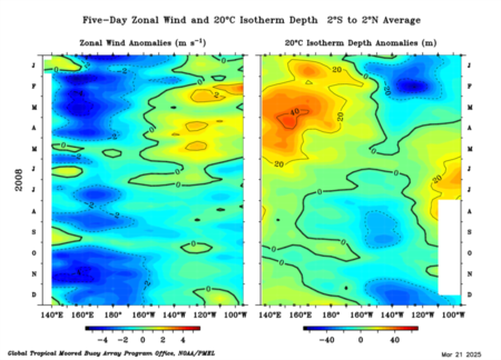
2008 behaved more like a traditional +ENSO event compared to 2025 and 2017. There was a strong downwelling KW during January and February in 2008. La Nina forcing near the dateline was weaker in 2008 compared to current observations and in 2017.

Image
3 likes   
RIP Kobe Bryant

User avatar
cycloneye
Admin
Admin
Posts: 143858
Age: 68
Joined: Thu Oct 10, 2002 10:54 am
Location: San Juan, Puerto Rico

Re: 2025 ENSO Updates

#98 Postby cycloneye » Fri Mar 21, 2025 3:26 pm

3 likes   
Visit the Caribbean-Central America Weather Thread where you can find at first post web cams,radars
and observations from Caribbean basin members Click Here

User avatar
Kingarabian
S2K Supporter
S2K Supporter
Posts: 15827
Joined: Sat Aug 08, 2009 3:06 am
Location: Honolulu, Hawaii

Re: 2025 ENSO Updates

#99 Postby Kingarabian » Fri Mar 21, 2025 5:08 pm


Correct. It's also not uncommon to see enhanced westerly winds in the EPAC when there's persistent strong trades near the dateline. Once summer rolls around those westerly winds in the EPAC start to have less impacts on the SSTs and become much less frequent.
2 likes   
RIP Kobe Bryant

User avatar
Ntxw
Storm2k Moderator
Storm2k Moderator
Posts: 22728
Joined: Wed Oct 21, 2009 6:34 pm
Location: DFW, Texas

Re: 2025 ENSO Updates

#100 Postby Ntxw » Fri Mar 21, 2025 5:26 pm

I don't think an El Nino is going to happen, nor do I think any meaningful Nina. SSTa around the globe is shifting, and we probably will see at times Nina influences, and others Nino like. It's one of those years with headfakes either way but is neutral, but a shifting global pattern.
0 likes   
The above post and any post by Ntxw is NOT an official forecast and should not be used as such. It is just the opinion of the poster and may or may not be backed by sound meteorological data. It is NOT endorsed by any professional institution including Storm2k. For official information, please refer to NWS products.

  Help support Storm2K!
Help Support Storm2K


Return to “Talkin' Tropics”

Who is online

Users browsing this forum: Blown Away and 101 guests