Texas Spring 2025
Moderator: S2k Moderators
Forum rules
The posts in this forum are NOT official forecast and should not be used as such. They are just the opinion of the poster and may or may not be backed by sound meteorological data. They are NOT endorsed by any professional institution or STORM2K.
- South Texas Storms
- Professional-Met

- Posts: 4256
- Joined: Thu Jun 24, 2010 12:28 am
- Location: Houston, TX
Re: Texas Spring 2025
I'm hoping the trough can dig a little deeper into Mexico before kicking out this weekend. If this occurs, like the 12z UKMET shows, this could allow a nice line of storms to build as far south as San Antonio Saturday morning. Areas north of IH-10 look to have the best storm chances with this system.
Next week looks very nice temperature-wise with chilly mornings and very pleasant afternoons. If it's not going to rain, I'll definitely take those conditions in April.
Next week looks very nice temperature-wise with chilly mornings and very pleasant afternoons. If it's not going to rain, I'll definitely take those conditions in April.
2 likes
- txtwister78
- Category 5

- Posts: 2159
- Joined: Wed Jan 30, 2019 12:56 pm
- Location: San Antonio
Re: Texas Spring 2025
South Texas Storms wrote:I'm hoping the trough can dig a little deeper into Mexico before kicking out this weekend. If this occurs, like the 12z UKMET shows, this could allow a nice line of storms to build as far south as San Antonio Saturday morning. Areas north of IH-10 look to have the best storm chances with this system.
Next week looks very nice temperature-wise with chilly mornings and very pleasant afternoons. If it's not going to rain, I'll definitely take those conditions in April.
Yup. 18z ICON looks a bit more promising in that regard. I'd be surprised if we don't end with something in our rain bucket Friday evening or Saturday morning before it's all said and done.
0 likes
- txtwister78
- Category 5

- Posts: 2159
- Joined: Wed Jan 30, 2019 12:56 pm
- Location: San Antonio
Re: Texas Spring 2025
Yeah they're fighting a cap so keeping most of these elevated as opposed to surface based. If they hold together tornado parameters increase across central Oklahoma so probably the other location to watch.
1 likes
- ElectricStorm
- Category 5

- Posts: 5135
- Age: 25
- Joined: Tue Aug 13, 2019 11:23 pm
- Location: Norman, OK
Re: Texas Spring 2025
0z OUN sounding still has a pretty significant cap, think the persistent cloud cover helped keep today in check so far, although it's not over yet by any means. Latest HRRR showing more cells firing later tonight so we'll see. Plus the ones near the Red River need to be watched but may remain hailers for a while
1 likes
B.S Meteorology, University of Oklahoma '25
Please refer to the NHC, NWS, or SPC for official information.
Please refer to the NHC, NWS, or SPC for official information.
-
HockeyTx82
- S2K Supporter

- Posts: 2781
- Joined: Tue Oct 27, 2009 11:17 am
- Location: Ponder, TX
Re: Texas Spring 2025
Looks like one just broke through south of Breckenridge, that's way out of the watch box.
0 likes
Don't hold me accountable for anything I post on this forum. Leave the real forecasting up to the professionals.
Location: Ponder, TX (all observation posts are this location unless otherwise noted)
Location: Ponder, TX (all observation posts are this location unless otherwise noted)
-
HockeyTx82
- S2K Supporter

- Posts: 2781
- Joined: Tue Oct 27, 2009 11:17 am
- Location: Ponder, TX
Re: Texas Spring 2025
Latest update takes all the heavy stuff north of the Red River for the night. I guess we'll have to wait for Wednesday evening Thursday morning for our DFW event now.
Not to say there could be a rogue storm or two overnight here but who knows
Not to say there could be a rogue storm or two overnight here but who knows
0 likes
Don't hold me accountable for anything I post on this forum. Leave the real forecasting up to the professionals.
Location: Ponder, TX (all observation posts are this location unless otherwise noted)
Location: Ponder, TX (all observation posts are this location unless otherwise noted)
- ElectricStorm
- Category 5

- Posts: 5135
- Age: 25
- Joined: Tue Aug 13, 2019 11:23 pm
- Location: Norman, OK
Re: Texas Spring 2025
That's two years in a row now we've had an underperforming event on April 1. April Fools I guess.
Looks like they kept the 10# for the overnight threat. We'll see
Looks like they kept the 10# for the overnight threat. We'll see
1 likes
B.S Meteorology, University of Oklahoma '25
Please refer to the NHC, NWS, or SPC for official information.
Please refer to the NHC, NWS, or SPC for official information.
Re: Texas Spring 2025
HockeyTx82 wrote:Latest update takes all the heavy stuff north of the Red River for the night. I guess we'll have to wait for Wednesday evening Thursday morning for our DFW event now.
Not to say there could be a rogue storm or two overnight here but who knows
00z HRRR still develops a quick-hitting line of storms for Collin / Denton County around sunrise tomorrow.
We'll see...
0 likes
- txtwister78
- Category 5

- Posts: 2159
- Joined: Wed Jan 30, 2019 12:56 pm
- Location: San Antonio
Re: Texas Spring 2025
One thing I mentioned a few days ago and will continue to watch as we get more model data in for late in the week (Thursday afternoon into Friday evening) is how far east and south this frontal boundary pushes with much cooler air behind it as this could really impact where severe weather/heavier rainfall sets up as these airmasses collide and our system finally ejects out of the SW.
The 0z 3km NAM is pretty bullish on pushing the front through DFW late afternoon Thursday and stalling it out somewhere east of I35 and also further south into the southern HC. If the NAM is accurate this could remove severe weather threat for a good chunk of N TX Friday including DFW metro and perhaps increase the severe weather threat for areas further south and east. Something to keep an eye on especially considering the NAM having a better overall track record with frontal boundaries and their overall progression compared to the globals.

The 0z 3km NAM is pretty bullish on pushing the front through DFW late afternoon Thursday and stalling it out somewhere east of I35 and also further south into the southern HC. If the NAM is accurate this could remove severe weather threat for a good chunk of N TX Friday including DFW metro and perhaps increase the severe weather threat for areas further south and east. Something to keep an eye on especially considering the NAM having a better overall track record with frontal boundaries and their overall progression compared to the globals.

0 likes
- ElectricStorm
- Category 5

- Posts: 5135
- Age: 25
- Joined: Tue Aug 13, 2019 11:23 pm
- Location: Norman, OK
Re: Texas Spring 2025
0 likes
B.S Meteorology, University of Oklahoma '25
Please refer to the NHC, NWS, or SPC for official information.
Please refer to the NHC, NWS, or SPC for official information.
Re: Texas Spring 2025
snownado wrote:HockeyTx82 wrote:Latest update takes all the heavy stuff north of the Red River for the night. I guess we'll have to wait for Wednesday evening Thursday morning for our DFW event now.
Not to say there could be a rogue storm or two overnight here but who knows
00z HRRR still develops a quick-hitting line of storms for Collin / Denton County around sunrise tomorrow.
We'll see...
All of the Hi-Res models show quick-hitting activity around sunrise for DFW, FWIW...
0 likes
-
HockeyTx82
- S2K Supporter

- Posts: 2781
- Joined: Tue Oct 27, 2009 11:17 am
- Location: Ponder, TX
Re: Texas Spring 2025
An early season High Risk for part of the country today. Stay safe everyone.
As far as NTX goes, it just seems like everything keeps getting pushed off and then have not happened. Sounds like overnight and early Thursday moring north of DFW could be the main event. Guess we will see.
I just want to be able to sleep and not wake up checking the radar every hour........
As far as NTX goes, it just seems like everything keeps getting pushed off and then have not happened. Sounds like overnight and early Thursday moring north of DFW could be the main event. Guess we will see.
I just want to be able to sleep and not wake up checking the radar every hour........
0 likes
Don't hold me accountable for anything I post on this forum. Leave the real forecasting up to the professionals.
Location: Ponder, TX (all observation posts are this location unless otherwise noted)
Location: Ponder, TX (all observation posts are this location unless otherwise noted)
-
Brent
- S2K Supporter

- Posts: 38722
- Age: 37
- Joined: Sun May 16, 2004 10:30 pm
- Location: Tulsa Oklahoma
- Contact:
Re: Texas Spring 2025
Big wakeup call up here
Still on track for a very chilly and wet weekend might even get a freeze if we clear out by Sunday
Arkansas may have their second historic tornado outbreak of the year btw
Still on track for a very chilly and wet weekend
Arkansas may have their second historic tornado outbreak of the year btw
0 likes
#neversummer
- wxman22
- Category 5

- Posts: 1882
- Joined: Mon Jan 30, 2006 12:39 am
- Location: Wichita Falls, TX
- Contact:
Re: Texas Spring 2025
We had a quick squall line move in this morning.This looks to be the wettest setup we’ve seen since November up here. With multiple rounds of moderate to heavy rain over the next few days.
1 likes
- cheezyWXguy
- Category 5

- Posts: 6280
- Joined: Mon Feb 13, 2006 12:29 am
- Location: Dallas, TX
Re: Texas Spring 2025
snownado wrote:snownado wrote:HockeyTx82 wrote:Latest update takes all the heavy stuff north of the Red River for the night. I guess we'll have to wait for Wednesday evening Thursday morning for our DFW event now.
Not to say there could be a rogue storm or two overnight here but who knows
00z HRRR still develops a quick-hitting line of storms for Collin / Denton County around sunrise tomorrow.
We'll see...
All of the Hi-Res models show quick-hitting activity around sunrise for DFW, FWIW...
More concerned about the round for overnight tonight. The 6z hrrr has some mean looking supercells tracking through north Texas
1 likes
- Iceresistance
- Category 5

- Posts: 9577
- Age: 22
- Joined: Sat Oct 10, 2020 9:45 am
- Location: Tecumseh, OK/Norman, OK
Re: Texas Spring 2025
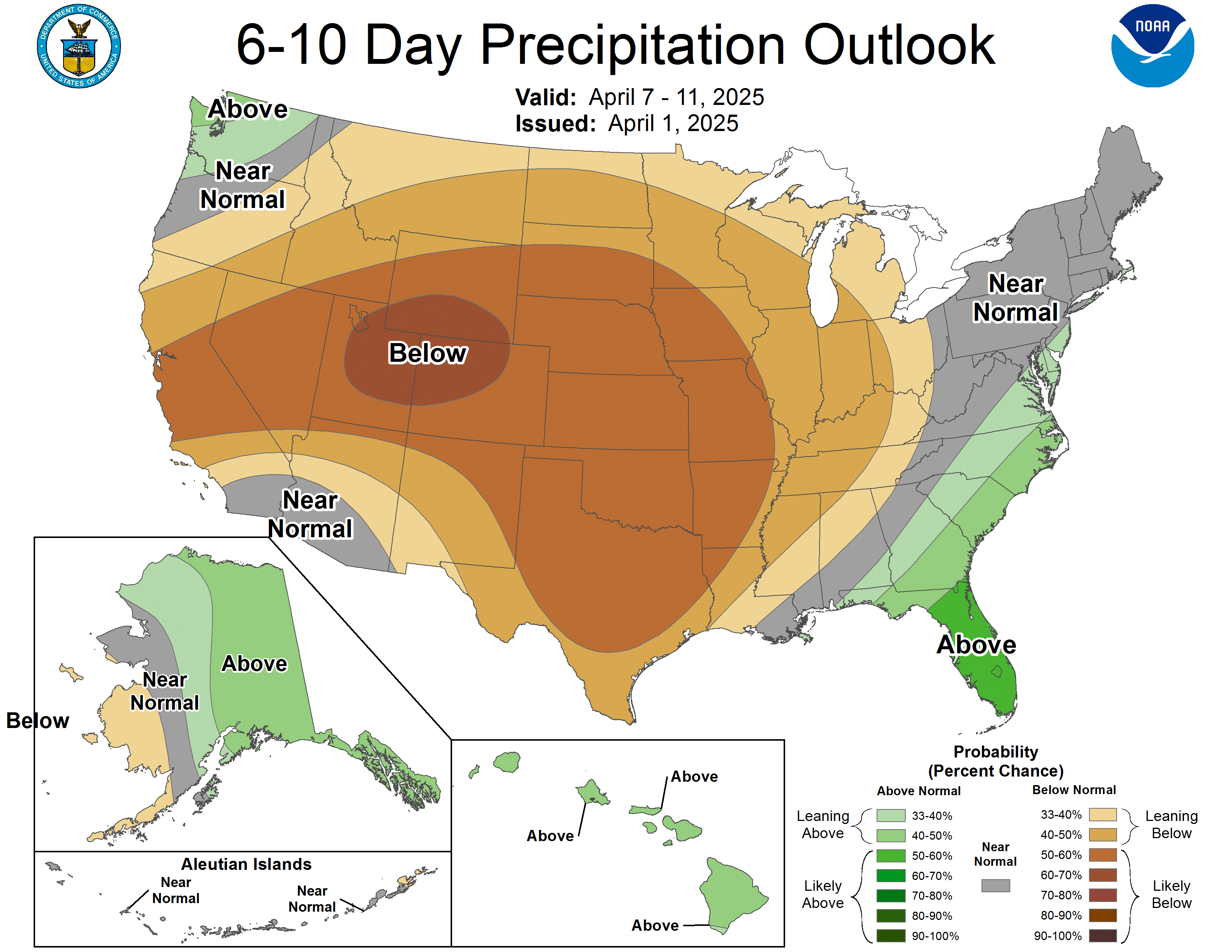
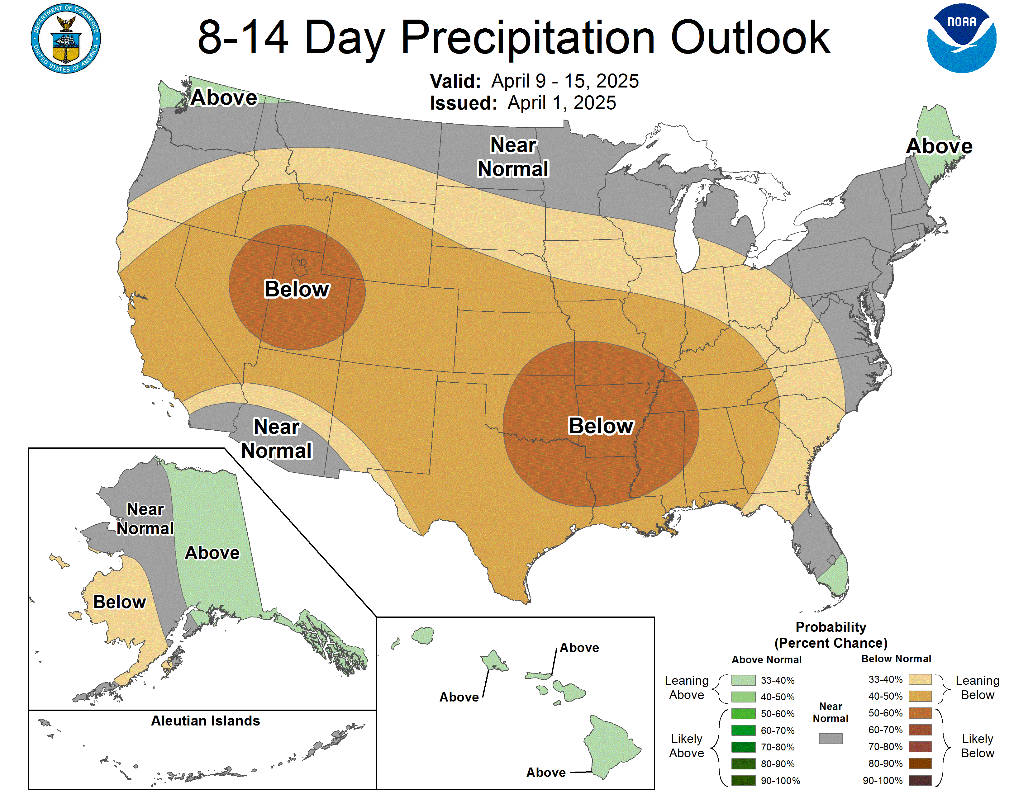
Not a good look, and it's going to last a couple of weeks after this storm system moves away this weekend

https://s6.gifyu.com/images/bMxZZ.gif

https://s6.gifyu.com/images/bMxZa.gif

https://s6.gifyu.com/images/bMxZZ.gif

https://s6.gifyu.com/images/bMxZa.gif
0 likes
Bill 2015 & Beta 2020
Winter 2020-2021
All observations are in Tecumseh, OK unless otherwise noted.
Winter posts are focused mainly for Oklahoma & Texas.
Take any of my forecasts with a grain of salt, refer to the NWS, SPC, and NHC for official information
Never say Never with weather! Because ANYTHING is possible!
Winter 2020-2021

All observations are in Tecumseh, OK unless otherwise noted.
Winter posts are focused mainly for Oklahoma & Texas.
Take any of my forecasts with a grain of salt, refer to the NWS, SPC, and NHC for official information
Never say Never with weather! Because ANYTHING is possible!
-
Lagreeneyes03
- Category 2

- Posts: 609
- Joined: Mon Dec 09, 2013 10:53 am
- Location: Luxurious Lake Grapevine
Re: Texas Spring 2025
rwfromkansas wrote:After I posted that does look like maybe a bigger more widespread Wednesday night.
Of course, it's overnight again, not during the day.
I miss seeing those afternoon thunderheads.
I do love photographing them.
1 likes
I'm a Princess, not a forecaster.
- wxman22
- Category 5

- Posts: 1882
- Joined: Mon Jan 30, 2006 12:39 am
- Location: Wichita Falls, TX
- Contact:
Re: Texas Spring 2025
This is the kind of setup where there is so much shear available that you get elevated supercells in the cold sector. The HRRR shows multiple rounds of elevated supercells. The first round starting overnight around the I-20 corridor. With another round of supercells effecting NW Texas and Oklahoma overnight Thursday into Friday. Large Hail looks to be the primary threat.


1 likes
Return to “USA & Caribbean Weather”
Who is online
Users browsing this forum: ElectricStorm, Google [Bot], Stratton23, wxman22 and 62 guests


