2025 ENSO Updates

This is the general tropical discussion area. Anyone can take their shot at predicting a storms path.

Moderator: S2k Moderators

Forum rules

The posts in this forum are NOT official forecasts and should not be used as such. They are just the opinion of the poster and may or may not be backed by sound meteorological data. They are NOT endorsed by any professional institution or STORM2K. For official information, please refer to products from the National Hurricane Center and National Weather Service.

Help Support Storm2K
Message
Author
User avatar
DorkyMcDorkface
Category 3
Category 3
Posts: 816
Age: 27
Joined: Mon Sep 30, 2019 1:32 pm
Location: Mid-Atlantic

Re: 2025 ENSO Updates

#101 Postby DorkyMcDorkface » Fri Mar 21, 2025 9:06 pm

Ntxw wrote:I don't think an El Nino is going to happen, nor do I think any meaningful Nina. SSTa around the globe is shifting, and we probably will see at times Nina influences, and others Nino like. It's one of those years with headfakes either way but is neutral, but a shifting global pattern.

Neutral is definitely the best bet for the foreseeable future, but eventually I honestly wouldn't be surprised if La Niña re-emerges later in the year, as atmospherically, the background state strongly resembles one despite an anemic SST profile and persistent westerlies in the equatorial EPAC. OLR is indicative of this in the Central and Western Pacific as well, and thee is a clear suppressed standing wave that continues to produce easterly wind bursts (which in turn will probably chip away at the Niño costero look eventually as well given how shallow the warmth is in those regions)
Image
Image

Image
4 likes   
Please note the thougths expressed by this account are solely those of the user and are from a hobbyist perspective. For more comprehensive analysis, consult an actual professional meteorologist or meteorology agency.


Floyd 1999 | Isabel 2003 | Hanna 2008 | Irene 2011 | Sandy 2012 | Isaias 2020

User avatar
Kingarabian
S2K Supporter
S2K Supporter
Posts: 15827
Joined: Sat Aug 08, 2009 3:06 am
Location: Honolulu, Hawaii

Re: 2025 ENSO Updates

#102 Postby Kingarabian » Sat Mar 22, 2025 11:43 am

2026 will possibly be different. But that remains to be seen. For ASO 2025, I think that cool neutral/weak Nina is much more likely than a sustained +ENSO event.

GFS has really backed off its strong WPAC WWB which essentially shuts the door on +ENSO before the fall of 2025 -- if at all. MJO becomes less and less influential in regards to +ENSO till September. Which means that the base state (weak La Nina) will control things soon. We should see a reversal by the last week of July.
4 likes   
RIP Kobe Bryant

User avatar
cycloneye
Admin
Admin
Posts: 143860
Age: 68
Joined: Thu Oct 10, 2002 10:54 am
Location: San Juan, Puerto Rico

Re: 2025 ENSO Updates

#103 Postby cycloneye » Mon Mar 24, 2025 8:29 am

The CPC weekly update has all 4 areas cooling a little bit.

https://www.cpc.ncep.noaa.gov/products/ ... ts-web.pdf

Image
0 likes   
Visit the Caribbean-Central America Weather Thread where you can find at first post web cams,radars
and observations from Caribbean basin members Click Here

User avatar
cycloneye
Admin
Admin
Posts: 143860
Age: 68
Joined: Thu Oct 10, 2002 10:54 am
Location: San Juan, Puerto Rico

Re: 2025 ENSO Updates

#104 Postby cycloneye » Mon Mar 31, 2025 8:40 am

Niño 3.4 is at +0.1C on this 3/31/25 CPC update.

https://www.cpc.ncep.noaa.gov/products/ ... ts-web.pdf

Image
0 likes   
Visit the Caribbean-Central America Weather Thread where you can find at first post web cams,radars
and observations from Caribbean basin members Click Here

User avatar
Yellow Evan
Professional-Met
Professional-Met
Posts: 16058
Age: 26
Joined: Fri Jul 15, 2011 12:48 pm
Location: Henderson, Nevada/Honolulu, HI
Contact:

Re: 2025 ENSO Updates

#105 Postby Yellow Evan » Mon Mar 31, 2025 1:20 pm

Neutral feels like a good bet. Pacific MJO penetration hasn't sparked the WWBs needed to relax trades and trigger a downwelling KW but the atmospheric state hasn't been particularly Nina happy, we are already at dead set neutral at the end of March, and given how relatively weak last year's bonafide Nina was, odds are against a stronger one emerging historically. Furthermore, the Atlantic tropics are cooling and -PDO has eroded.

A Nino in 2026 would be consistent with historical return periods of El Nino in absence of a major La Nina event in between.
3 likes   

User avatar
DorkyMcDorkface
Category 3
Category 3
Posts: 816
Age: 27
Joined: Mon Sep 30, 2019 1:32 pm
Location: Mid-Atlantic

Re: 2025 ENSO Updates

#106 Postby DorkyMcDorkface » Mon Mar 31, 2025 2:31 pm

Yellow Evan wrote:Neutral feels like a good bet. Pacific MJO penetration hasn't sparked the WWBs needed to relax trades and trigger a downwelling KW but the atmospheric state hasn't been particularly Nina happy, we are already at dead set neutral at the end of March, and given how relatively weak last year's bonafide Nina was, odds are against a stronger one emerging historically. Furthermore, the Atlantic tropics are cooling and -PDO has eroded.

A Nino in 2026 would be consistent with historical return periods of El Nino in absence of a major La Nina event in between.

Yeah I should have clarified, if La Niña were in fact to re-emerge I think it will be similar to last year in that it'll be a very weak event. But we're definitely on trajectory for cool-neutral, and I do think we'll eventually axe the Niño Costero look though, as a matter of fact it appears that may already be happening:
Image
2 likes   

Please note the thougths expressed by this account are solely those of the user and are from a hobbyist perspective. For more comprehensive analysis, consult an actual professional meteorologist or meteorology agency.


Floyd 1999 | Isabel 2003 | Hanna 2008 | Irene 2011 | Sandy 2012 | Isaias 2020

User avatar
cycloneye
Admin
Admin
Posts: 143860
Age: 68
Joined: Thu Oct 10, 2002 10:54 am
Location: San Juan, Puerto Rico

Re: 2025 ENSO Updates

#107 Postby cycloneye » Tue Apr 01, 2025 12:16 pm

0 likes   
Visit the Caribbean-Central America Weather Thread where you can find at first post web cams,radars
and observations from Caribbean basin members Click Here

User avatar
cycloneye
Admin
Admin
Posts: 143860
Age: 68
Joined: Thu Oct 10, 2002 10:54 am
Location: San Juan, Puerto Rico

Re: 2025 ENSO Updates

#108 Postby cycloneye » Thu Apr 03, 2025 11:26 am

0 likes   
Visit the Caribbean-Central America Weather Thread where you can find at first post web cams,radars
and observations from Caribbean basin members Click Here

User avatar
Ntxw
Storm2k Moderator
Storm2k Moderator
Posts: 22728
Joined: Wed Oct 21, 2009 6:34 pm
Location: DFW, Texas

Re: 2025 ENSO Updates

#109 Postby Ntxw » Thu Apr 03, 2025 4:32 pm

You can argue the other parameters with valid points for sure, but per ONI JFM came in at -0.4F which in total will not qualify as an official Nina this past winter and late year. The NPAC extratropics did not feature a very Nina-like response. This is the theme of the past 2 ENSO cycles where the NPAC goes against traditional Nino/Nina tendencies.
0 likes   
The above post and any post by Ntxw is NOT an official forecast and should not be used as such. It is just the opinion of the poster and may or may not be backed by sound meteorological data. It is NOT endorsed by any professional institution including Storm2k. For official information, please refer to NWS products.

  Help support Storm2K!
Help Support Storm2K

User avatar
Kingarabian
S2K Supporter
S2K Supporter
Posts: 15827
Joined: Sat Aug 08, 2009 3:06 am
Location: Honolulu, Hawaii

Re: 2025 ENSO Updates

#110 Postby Kingarabian » Sun Apr 06, 2025 7:28 pm

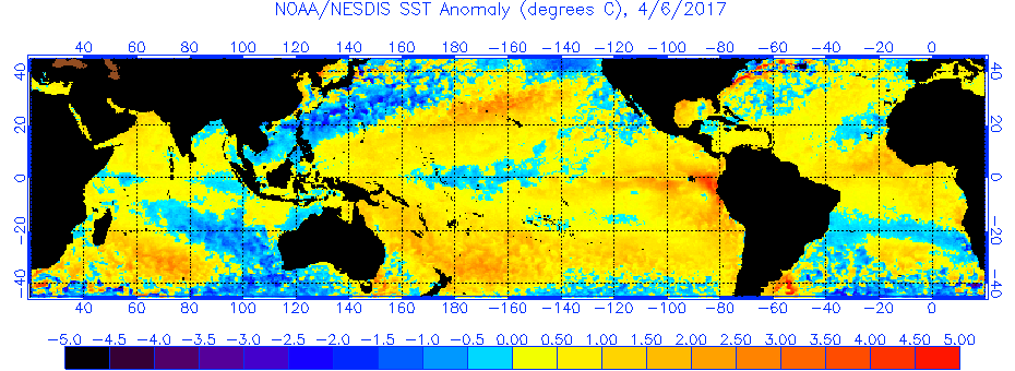
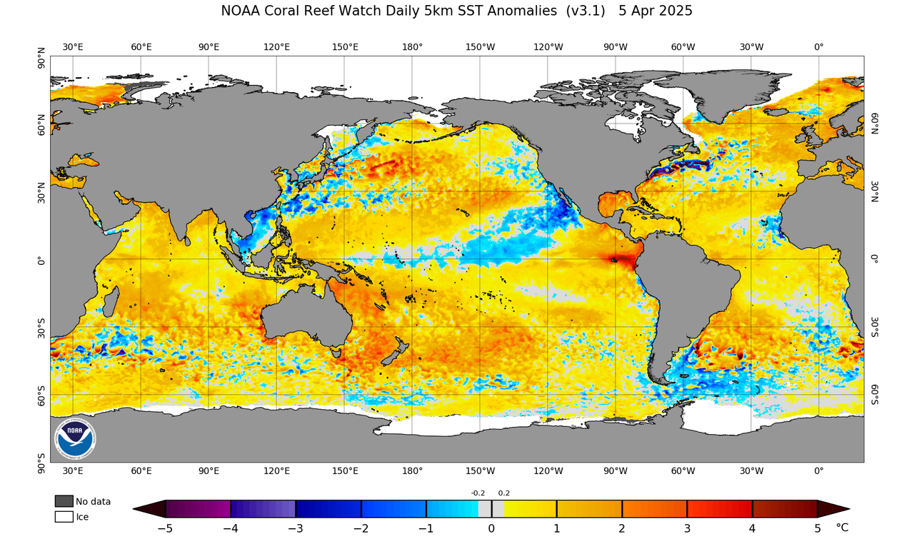
Most of the warmth near the Nino regions is from the SEPAC. Similar to 2017.

Image
Image
1 likes   
RIP Kobe Bryant

User avatar
cycloneye
Admin
Admin
Posts: 143860
Age: 68
Joined: Thu Oct 10, 2002 10:54 am
Location: San Juan, Puerto Rico

Re: 2025 ENSO Updates

#111 Postby cycloneye » Mon Apr 07, 2025 8:18 am

CPC weekly update has niño 3.4 down to -0.1C.

https://www.cpc.ncep.noaa.gov/products/ ... ts-web.pdf
0 likes   
Visit the Caribbean-Central America Weather Thread where you can find at first post web cams,radars
and observations from Caribbean basin members Click Here

User avatar
cycloneye
Admin
Admin
Posts: 143860
Age: 68
Joined: Thu Oct 10, 2002 10:54 am
Location: San Juan, Puerto Rico

Re: 2025 ENSO Updates

#112 Postby cycloneye » Mon Apr 07, 2025 8:22 am

0 likes   
Visit the Caribbean-Central America Weather Thread where you can find at first post web cams,radars
and observations from Caribbean basin members Click Here

User avatar
cycloneye
Admin
Admin
Posts: 143860
Age: 68
Joined: Thu Oct 10, 2002 10:54 am
Location: San Juan, Puerto Rico

Re: 2025 ENSO Updates: Breaking News: La Niña has ended

#113 Postby cycloneye » Thu Apr 10, 2025 8:10 am

4 likes   
Visit the Caribbean-Central America Weather Thread where you can find at first post web cams,radars
and observations from Caribbean basin members Click Here

User avatar
cycloneye
Admin
Admin
Posts: 143860
Age: 68
Joined: Thu Oct 10, 2002 10:54 am
Location: San Juan, Puerto Rico

Re: 2025 ENSO Updates: La Niña has ended

#114 Postby cycloneye » Thu Apr 10, 2025 10:56 am

Here are the details about why they ended La Niña advisories in the blog they have.

ENSO Blog
0 likes   
Visit the Caribbean-Central America Weather Thread where you can find at first post web cams,radars
and observations from Caribbean basin members Click Here

User avatar
Ntxw
Storm2k Moderator
Storm2k Moderator
Posts: 22728
Joined: Wed Oct 21, 2009 6:34 pm
Location: DFW, Texas

Re: 2025 ENSO Updates: La Niña has ended / Neutral thru October / Low chance for El NIño

#115 Postby Ntxw » Thu Apr 10, 2025 1:30 pm

For me this is the most interesting tidbit from the blog. So operational is not a La Nina but they anticipate with warming SST averages in the future it will revise to possibly qualify ten years down the road in retrospect.

The reason for mentioning this detail is that this past winter does not qualify as a La Niña event in our historical table, because it did not last 5 consecutive rolling seasons (we call any 3-month-average a season) exceeding the -0.5 °C threshold. However, in 2036, this past winter will be near the middle of a 30-year period (2006–2035), which is very likely to be warmer than the 1991–2020 average. Thus, with the benefit of another decade, this year’s small La Niña may be cooler when compared to that warmer averaging period. So, in 2036, the 2024–25 winter may end up colored blue, and be considered a formal La Niña, in the historical table.
6 likes   
The above post and any post by Ntxw is NOT an official forecast and should not be used as such. It is just the opinion of the poster and may or may not be backed by sound meteorological data. It is NOT endorsed by any professional institution including Storm2k. For official information, please refer to NWS products.


  Help support Storm2K!

Help Support Storm2K


User avatar
DorkyMcDorkface
Category 3
Category 3
Posts: 816
Age: 27
Joined: Mon Sep 30, 2019 1:32 pm
Location: Mid-Atlantic

Re: 2025 ENSO Updates: La Niña has ended / Neutral thru October / Low chance for El NIño

#116 Postby DorkyMcDorkface » Thu Apr 10, 2025 2:00 pm

Ntxw wrote:For me this is the most interesting tidbit from the blog. So operational is not a La Nina but they anticipate with warming SST averages in the future it will revise to possibly qualify ten years down the road in retrospect.

The reason for mentioning this detail is that this past winter does not qualify as a La Niña event in our historical table, because it did not last 5 consecutive rolling seasons (we call any 3-month-average a season) exceeding the -0.5 °C threshold. However, in 2036, this past winter will be near the middle of a 30-year period (2006–2035), which is very likely to be warmer than the 1991–2020 average. Thus, with the benefit of another decade, this year’s small La Niña may be cooler when compared to that warmer averaging period. So, in 2036, the 2024–25 winter may end up colored blue, and be considered a formal La Niña, in the historical table.

I honestly wonder if the BOM might follow suit in making adjustments given their La Niña (El Niño) threshold is lower at -0.7C (higher at 0.7C)
2 likes   

Please note the thougths expressed by this account are solely those of the user and are from a hobbyist perspective. For more comprehensive analysis, consult an actual professional meteorologist or meteorology agency.


Floyd 1999 | Isabel 2003 | Hanna 2008 | Irene 2011 | Sandy 2012 | Isaias 2020

USTropics
Category 5
Category 5
Posts: 2635
Joined: Sun Aug 12, 2007 3:45 am
Location: Florida State University

Re: 2025 ENSO Updates: La Niña has ended / Neutral thru October / Low chance for El NIño

#117 Postby USTropics » Thu Apr 10, 2025 2:00 pm

Ntxw wrote:For me this is the most interesting tidbit from the blog. So operational is not a La Nina but they anticipate with warming SST averages in the future it will revise to possibly qualify ten years down the road in retrospect.

The reason for mentioning this detail is that this past winter does not qualify as a La Niña event in our historical table, because it did not last 5 consecutive rolling seasons (we call any 3-month-average a season) exceeding the -0.5 °C threshold. However, in 2036, this past winter will be near the middle of a 30-year period (2006–2035), which is very likely to be warmer than the 1991–2020 average. Thus, with the benefit of another decade, this year’s small La Niña may be cooler when compared to that warmer averaging period. So, in 2036, the 2024–25 winter may end up colored blue, and be considered a formal La Niña, in the historical table.


Personally, I think the index/table will need to be revised way before then. Subtracting out the global mean to reduce the long range climate signal is the way to go. Alex/Sparta has a good product for this:

Image
https://cyclonicwx.com/sst/

Most graduate students here at FSU and recent research are applying similar techniques, and the correlation between ocean -> atmospheric modes is improved.
https://www.science.org/doi/full/10.1126/sciadv.adj5569
https://agupubs.onlinelibrary.wiley.com/doi/full/10.1029/2024GL113733
https://journals.ametsoc.org/view/journals/clim/37/4/JCLI-D-23-0406.1.xml

The main reason is, if we want to focus on the SST pattern near the equator (i.e., tropics), we need to isolate this region and remove biases. Where is it warming up the quickest? In the polar regions:
Image

So we either wait for the sliding climatology to grab enough data points (2036), or we apply methods like RONI now.
9 likes   

User avatar
Kingarabian
S2K Supporter
S2K Supporter
Posts: 15827
Joined: Sat Aug 08, 2009 3:06 am
Location: Honolulu, Hawaii

Re: 2025 ENSO Updates: La Niña has ended / Neutral thru October / Low chance for El NIño

#118 Postby Kingarabian » Fri Apr 11, 2025 8:50 am

NCEP models showing dateline trades finally relaxing over the next 2 weeks. Too late though.
1 likes   
RIP Kobe Bryant

User avatar
Ntxw
Storm2k Moderator
Storm2k Moderator
Posts: 22728
Joined: Wed Oct 21, 2009 6:34 pm
Location: DFW, Texas

Re: 2025 ENSO Updates: La Niña has ended / Neutral thru October / Low chance for El NIño

#119 Postby Ntxw » Fri Apr 11, 2025 9:02 am

USTropics wrote:
Ntxw wrote:For me this is the most interesting tidbit from the blog. So operational is not a La Nina but they anticipate with warming SST averages in the future it will revise to possibly qualify ten years down the road in retrospect.

The reason for mentioning this detail is that this past winter does not qualify as a La Niña event in our historical table, because it did not last 5 consecutive rolling seasons (we call any 3-month-average a season) exceeding the -0.5 °C threshold. However, in 2036, this past winter will be near the middle of a 30-year period (2006–2035), which is very likely to be warmer than the 1991–2020 average. Thus, with the benefit of another decade, this year’s small La Niña may be cooler when compared to that warmer averaging period. So, in 2036, the 2024–25 winter may end up colored blue, and be considered a formal La Niña, in the historical table.


Personally, I think the index/table will need to be revised way before then. Subtracting out the global mean to reduce the long range climate signal is the way to go. Alex/Sparta has a good product for this:

https://i.imgur.com/2EGF6H5.png
https://cyclonicwx.com/sst/

Most graduate students here at FSU and recent research are applying similar techniques, and the correlation between ocean -> atmospheric modes is improved.
https://www.science.org/doi/full/10.1126/sciadv.adj5569
https://agupubs.onlinelibrary.wiley.com/doi/full/10.1029/2024GL113733
https://journals.ametsoc.org/view/journals/clim/37/4/JCLI-D-23-0406.1.xml

The main reason is, if we want to focus on the SST pattern near the equator (i.e., tropics), we need to isolate this region and remove biases. Where is it warming up the quickest? In the polar regions:
https://i.imgur.com/IBeJHxm.jpeg

So we either wait for the sliding climatology to grab enough data points (2036), or we apply methods like RONI now.


No doubt improved methods may provide better insights with fast-paced changing warmth. The question I've had is not that we shouldn't expand to different methodologies, but we don't know the effects of using these methods (such as the RONI) and then assume the effects will remain the same (linkage from tropical to extratropics etc.) As we have seen the past couple of seasons simply saying 'It's a stronger La Nina per RONI, or weaker El Nino' but yet the response is not what it should be, the broader understanding fundamentally needs to change. We can't use old data sets and expect the same result as it evolves. I don't think simply subtracting one region from another is the best answer (though better than what we have), because you're talking about actual expanding SSTs beyond trop Pacific that would sustain convection which historically didn't in more areas. Hadley cell expansion, walker circulation changes are problematic in relation to ENSO.
1 likes   
The above post and any post by Ntxw is NOT an official forecast and should not be used as such. It is just the opinion of the poster and may or may not be backed by sound meteorological data. It is NOT endorsed by any professional institution including Storm2k. For official information, please refer to NWS products.


  Help support Storm2K!

Help Support Storm2K


User avatar
Kingarabian
S2K Supporter
S2K Supporter
Posts: 15827
Joined: Sat Aug 08, 2009 3:06 am
Location: Honolulu, Hawaii

Re: 2025 ENSO Updates: La Niña has ended / Neutral thru October / Low chance for El NIño

#120 Postby Kingarabian » Fri Apr 11, 2025 9:25 am

Ntxw wrote:
USTropics wrote:
Ntxw wrote:For me this is the most interesting tidbit from the blog. So operational is not a La Nina but they anticipate with warming SST averages in the future it will revise to possibly qualify ten years down the road in retrospect.

The reason for mentioning this detail is that this past winter does not qualify as a La Niña event in our historical table, because it did not last 5 consecutive rolling seasons (we call any 3-month-average a season) exceeding the -0.5 °C threshold. However, in 2036, this past winter will be near the middle of a 30-year period (2006–2035), which is very likely to be warmer than the 1991–2020 average. Thus, with the benefit of another decade, this year’s small La Niña may be cooler when compared to that warmer averaging period. So, in 2036, the 2024–25 winter may end up colored blue, and be considered a formal La Niña, in the historical table.


Personally, I think the index/table will need to be revised way before then. Subtracting out the global mean to reduce the long range climate signal is the way to go. Alex/Sparta has a good product for this:

https://i.imgur.com/2EGF6H5.png
https://cyclonicwx.com/sst/

Most graduate students here at FSU and recent research are applying similar techniques, and the correlation between ocean -> atmospheric modes is improved.
https://www.science.org/doi/full/10.1126/sciadv.adj5569
https://agupubs.onlinelibrary.wiley.com/doi/full/10.1029/2024GL113733
https://journals.ametsoc.org/view/journals/clim/37/4/JCLI-D-23-0406.1.xml

The main reason is, if we want to focus on the SST pattern near the equator (i.e., tropics), we need to isolate this region and remove biases. Where is it warming up the quickest? In the polar regions:
https://i.imgur.com/IBeJHxm.jpeg

So we either wait for the sliding climatology to grab enough data points (2036), or we apply methods like RONI now.


No doubt improved methods may provide better insights with fast-paced changing warmth. The question I've had is not that we shouldn't expand to different methodologies, but we don't know the effects of using these methods (such as the RONI) and then assume the effects will remain the same (linkage from tropical to extratropics etc.) As we have seen the past couple of seasons simply saying 'It's a stronger La Nina per RONI, or weaker El Nino' but yet the response is not what it should be, the broader understanding fundamentally needs to change. We can't use old data sets and expect the same result as it evolves. I don't think simply subtracting one region from another is the best answer (though better than what we have), because you're talking about actual expanding SSTs beyond trop Pacific that would sustain convection which historically didn't in more areas. Hadley cell expansion, walker circulation changes are problematic in relation to ENSO.


I agree here. The most recent strong El Nino and this most recent weak La Nina had atypical atmosphere and extra tropical reponses.
2 likes   
RIP Kobe Bryant


Return to “Talkin' Tropics”

Who is online

Users browsing this forum: cycloneye, Lizzytiz1 and 72 guests