96P INVEST 250408 1200 10.0S 137.0E SHEM 15 0
SIO: ERROL - Post-Tropical
Moderator: S2k Moderators
SIO: ERROL - Post-Tropical
Last edited by Subtrop on Wed Apr 16, 2025 1:55 am, edited 3 times in total.
0 likes
-
Hurricane2022

- Category 5

- Posts: 2096
- Joined: Tue Aug 23, 2022 11:38 pm
- Location: Araçatuba, Brazil
Re: SPAC: INVEST 96P
?????


2 likes
Sorry for the bad English sometimes...!
For reliable and detailed information for any meteorological phenomenon, please consult the National Hurricane Center, Joint Typhoon Warning Center , or your local Meteo Center.
--------
ECCE OMNIA NOVA FACIAM (Ap 21,5).
For reliable and detailed information for any meteorological phenomenon, please consult the National Hurricane Center, Joint Typhoon Warning Center , or your local Meteo Center.
--------
ECCE OMNIA NOVA FACIAM (Ap 21,5).
-
cycloneye

- Admin

- Posts: 149843
- Age: 69
- Joined: Thu Oct 10, 2002 10:54 am
- Location: San Juan, Puerto Rico
Re: SPAC: INVEST 96P
Tropical Low 29U
High risk of tropical low (29U) developing into a tropical cyclone next week.
A tropical low (29U) is forming in the Arafura Sea, with a Moderate chance of development from Friday, most likely while it's over waters north to northwest of Darwin.
The system is expected to move southwest into the Timor Sea over the weekend, then shift west-southwest early next week.
As it moves over waters north of the Kimberley, the chance of tropical cyclone development increases to High early next week.
Coastal communities in the Kimberley should keep up to date with the latest forecasts
0 likes
Visit the Caribbean-Central America Weather Thread where you can find at first post web cams,radars
and observations from Caribbean basin members Click Here
and observations from Caribbean basin members Click Here
-
cycloneye
- Admin
- Posts: 149843
- Age: 69
- Joined: Thu Oct 10, 2002 10:54 am
- Location: San Juan, Puerto Rico
Re: SPAC: 29U - Tropical Low
Wow, it continues Hurricane2022.

2 likes
Visit the Caribbean-Central America Weather Thread where you can find at first post web cams,radars
and observations from Caribbean basin members Click Here
and observations from Caribbean basin members Click Here
-
cycloneye
- Admin
- Posts: 149843
- Age: 69
- Joined: Thu Oct 10, 2002 10:54 am
- Location: San Juan, Puerto Rico
Re: SPAC: 29U - Tropical Low
High risk of tropical low (29U) developing into a tropical cyclone from Sunday.
A tropical low (29U) has formed in the Arafura Sea, with a Moderate chance of development from Friday, most likely while it's over waters north to northwest of Darwin.
The system is expected to move southwest into the Timor Sea over the weekend, and the chance of tropical cyclone development increases to High from Sunday as 29U moves over waters north of the Kimberley.
There is a risk of coastal impacts to the northwest Kimberley over the weekend. Coastal communities in the Kimberley should keep up to date with the latest forecasts.
0 likes
Visit the Caribbean-Central America Weather Thread where you can find at first post web cams,radars
and observations from Caribbean basin members Click Here
and observations from Caribbean basin members Click Here
-
Hurricane2022
- Category 5
- Posts: 2096
- Joined: Tue Aug 23, 2022 11:38 pm
- Location: Araçatuba, Brazil
Re: SPAC: 29U - Tropical Low
cycloneye wrote:Wow, it continues Hurricane2022.
I can't remember when we last saw a sub-870 mb model forecast like that. Maybe in 2018, with the HWRF having consecutive strokes with Typhoon Mangkhut?
1 likes
Sorry for the bad English sometimes...!
For reliable and detailed information for any meteorological phenomenon, please consult the National Hurricane Center, Joint Typhoon Warning Center , or your local Meteo Center.
--------
ECCE OMNIA NOVA FACIAM (Ap 21,5).
For reliable and detailed information for any meteorological phenomenon, please consult the National Hurricane Center, Joint Typhoon Warning Center , or your local Meteo Center.
--------
ECCE OMNIA NOVA FACIAM (Ap 21,5).
-
Hurricane2022
- Category 5
- Posts: 2096
- Joined: Tue Aug 23, 2022 11:38 pm
- Location: Araçatuba, Brazil
Re: SPAC: 29U - Tropical Low
https://x.com/zeb199818/status/1910304273608630526
https://x.com/zeb199818/status/1910291801090756737
https://x.com/zeb199818/status/1910291801090756737
0 likes
Sorry for the bad English sometimes...!
For reliable and detailed information for any meteorological phenomenon, please consult the National Hurricane Center, Joint Typhoon Warning Center , or your local Meteo Center.
--------
ECCE OMNIA NOVA FACIAM (Ap 21,5).
For reliable and detailed information for any meteorological phenomenon, please consult the National Hurricane Center, Joint Typhoon Warning Center , or your local Meteo Center.
--------
ECCE OMNIA NOVA FACIAM (Ap 21,5).
-
WaveBreaking

- Category 2

- Posts: 728
- Joined: Sun Jun 30, 2024 11:33 am
- Location: US
Re: SPAC: 29U - Tropical Low
I don’t think it’ll do something too crazy, but it definitely has the look of something that has a high ceiling. The waters it’ll go over are rocket fuel.


0 likes
I am NOT a professional meteorologist, so take all of my posts with a grain of salt. My opinions are mine and mine alone.
-
cycloneye
- Admin
- Posts: 149843
- Age: 69
- Joined: Thu Oct 10, 2002 10:54 am
- Location: San Juan, Puerto Rico
Re: SPAC: 29U - Tropical Low
12z HAFS is much less strong.

2 likes
Visit the Caribbean-Central America Weather Thread where you can find at first post web cams,radars
and observations from Caribbean basin members Click Here
and observations from Caribbean basin members Click Here
-
cycloneye
- Admin
- Posts: 149843
- Age: 69
- Joined: Thu Oct 10, 2002 10:54 am
- Location: San Juan, Puerto Rico
Re: SPAC: 29U - Tropical Low
1 likes
Visit the Caribbean-Central America Weather Thread where you can find at first post web cams,radars
and observations from Caribbean basin members Click Here
and observations from Caribbean basin members Click Here

Re: SPAC: 29U - Tropical Low
This has to be (at least close to) the record for run-to-run intensity changes, right?
3 likes
TC naming lists: retirements and intensity
Most aggressive Advisory #1's in North Atlantic (cr. kevin for starting the list)
Most aggressive Advisory #1's in North Atlantic (cr. kevin for starting the list)

Re: SPAC: 29U - Tropical Low
Teban54 wrote:
This has to be (at least close to) the record for run-to-run intensity changes, right?
https://i.postimg.cc/7YwHG87V/hafsa-mslp-wind-96-P-fh120-trend.gif
That's one metric Cat 4 cyclone between the two runs, there's a bigger difference between them than the absolute intensity of the 12z run!
1 likes
-
cycloneye
- Admin
- Posts: 149843
- Age: 69
- Joined: Thu Oct 10, 2002 10:54 am
- Location: San Juan, Puerto Rico
Re: SPAC: 29U - Tropical Low
TROPICAL CYCLONE INFORMATION BULLETIN
Issued at 2:40 am WST on Friday 11 April 2025
A Tropical Low (29U) was located at 2:00 am AWST near 8.8S 129.6E, that is 425
km north northwest of Darwin and 305 km north northwest of Pirlangimpi, and
moving west southwest at 8 kilometres per hour.
Tropical Low 29U is located to the north-northwest of Darwin, and is forecast
to move southwest, across the Timor Sea over the next few days, while remaining
off the western Top End coast.
29U is expected to develop into a tropical cyclone on the weekend with
increasing risk of coastal impacts for the Kimberley coast from late Saturday.
0 likes
Visit the Caribbean-Central America Weather Thread where you can find at first post web cams,radars
and observations from Caribbean basin members Click Here
and observations from Caribbean basin members Click Here
-
Hurricane2022
- Category 5
- Posts: 2096
- Joined: Tue Aug 23, 2022 11:38 pm
- Location: Araçatuba, Brazil
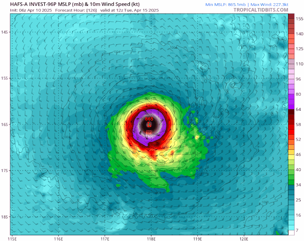
Re: SPAC: 29U - Tropical Low
HAFS-A goes crazy again on this 18z run. Now it shows future Errol/Bakung briefly passing over Australia, and later doing multiple EWRCs before a 906 mb peak at T126
2 likes
Sorry for the bad English sometimes...!
For reliable and detailed information for any meteorological phenomenon, please consult the National Hurricane Center, Joint Typhoon Warning Center , or your local Meteo Center.
--------
ECCE OMNIA NOVA FACIAM (Ap 21,5).
For reliable and detailed information for any meteorological phenomenon, please consult the National Hurricane Center, Joint Typhoon Warning Center , or your local Meteo Center.
--------
ECCE OMNIA NOVA FACIAM (Ap 21,5).
Re: SPAC: 29U - Tropical Low
While I doubt the HAFS model 29U does looks to become a car 5 storm.


0 likes
Re: SPAC: 29U - Tropical Low
Here is 29U at the moment showing good development with inflow and outflow.
KOMPDAT-2a GeoProxy 2 hour loop

KOMPDAT-2a GeoProxy 2 hour loop
0 likes
-
cycloneye
- Admin
- Posts: 149843
- Age: 69
- Joined: Thu Oct 10, 2002 10:54 am
- Location: San Juan, Puerto Rico
Re: SPAC: 29U - Tropical Low
TROPICAL CYCLONE TECHNICAL BULLETIN: AUSTRALIA - WESTERN REGION
Issued by AUSTRALIAN BUREAU OF METEOROLOGY TROPICAL CYCLONE WARNING CENTRE
at: 0701 UTC 11/04/2025
Name: Tropical Low
Identifier: 29U
Data At: 0600 UTC
Latitude: 8.9S
Longitude: 129.3E
Location Accuracy: within 20nm (35 km)
Movement Towards: southwest (230 deg)
Speed of Movement: 4 knots (7 km/h)
Maximum 10-Minute Wind: 30 knots (55 km/h)
Maximum 3-Second Wind Gust: 45 knots (85 km/h)
Central Pressure: 999 hPa
Radius of 34-knot winds NE quadrant:
Radius of 34-knot winds SE quadrant:
Radius of 34-knot winds SW quadrant:
Radius of 34-knot winds NW quadrant:
Radius of 48-knot winds NE quadrant:
Radius of 48-knot winds SE quadrant:
Radius of 48-knot winds SW quadrant:
Radius of 48-knot winds NW quadrant:
Radius of 64-knot winds: nm ( km)
Radius of Maximum Winds: nm ( km)
Dvorak Intensity Code: T2.0/2.0/D0.5/24HRS STT:S0.0/06HRS
Pressure of outermost isobar: 1005 hPa
Radius of outermost closed isobar: 100 nm (185 km)
FORECAST DATA
Date/Time : Location : Loc. Accuracy: Max Wind : Central Pressure
(UTC) : degrees : nm (km): knots(km/h): hPa
+06: 11/1200: 9.6S 128.8E: 030 (060): 030 (055): 1000
+12: 11/1800: 10.2S 128.4E: 040 (075): 035 (065): 997
+18: 12/0000: 10.8S 128.0E: 050 (090): 035 (065): 997
+24: 12/0600: 11.3S 127.6E: 055 (100): 040 (075): 995
+36: 12/1800: 12.1S 126.5E: 075 (140): 040 (075): 995
+48: 13/0600: 12.7S 125.2E: 105 (195): 050 (095): 989
+60: 13/1800: 13.2S 123.8E: 135 (245): 055 (100): 985
+72: 14/0600: 13.7S 122.9E: 150 (280): 060 (110): 981
+96: 15/0600: 14.1S 121.0E: 195 (365): 075 (140): 969
+120: 16/0600: 14.6S 118.9E: 240 (445): 085 (155): 960
REMARKS:
Tropical Low 29U lies over the far northern Timor Sea and is drifting to the
southwest. A more exposed LLCC during the day with the deep convection largely
displaced to the southwest has made the centre easier to locate. There is good
confidence in the centre position, which has been based on animated visible
imagery.
Dvorak analysis is based on curved band (0.3-0.45 wrap) and shear (estimated
LLCC less than half a degree from CDO) patterns averaged over 3 hours, giving
DTs of 2.0-3.0 with neither pattern clear cut. MET is 2.5 based on a D trend.
PAT adjusted to 2.0. FT and CI 2.0. Intensity set at 30 knots, based on recent
OSCAT at 0330 UTC with 30 kn to the southwest of the centre, and persistence.
Convection to the southwest of the centre has fluctuated through the day, in
recent hours there has been improved curvature and convection nearer the
centre, with a CDO just starting to obscure the LLCC. However, the system does
lie near a strong gradient of dep layer shear and displacement seen in
satellite imagery suggests northeasterly shear continues to impact the vertical
alignment of the system.
Along the forecast track to the southwest, conditions should improve as the
system enters a lower shear channel overnight and into the weekend. Deep
tropical moisture and high SSTs (30-31C) are otherwise in place, and a
shortwave upper trough to the SW is improving poleward outflow and upper
divergence. Slow to standard development is forecast in the short term, with
the effects of shear likely to continue to be felt, and only limited low level
forcing on the northern side. In the medium term development may become more
rapid as the system moves into lower deep layer shear. It should be noted that
29U is a small system and thus prone to rapid intensity fluctuations as it
responds quickly to positive and negative changes in the environment. It may
therefore strengthen more rapidly than forecast, and potentially become
stronger than forecast if conditions improve.
A mid-level ridge to the southwest will be the dominant influence on the motion
of 29U over the coming week and will steer the system steadily to the west. In
the shorter term, a mid-level trough extending from eastern Australia will
introduce a southward component to the motion and thus 29U will move southwest
over the weekend. This may bring it close to the Kimberley coast late Saturday
or during Sunday. From about Monday, the influence of the trough will wane and
movement will become more west southwest or westward. Around mid-next week,
another upper trough is expected to amplify over southwest WA which may steer
the system towards the WA coast, however there is high uncertainty at this lead
time.
0 likes
Visit the Caribbean-Central America Weather Thread where you can find at first post web cams,radars
and observations from Caribbean basin members Click Here
and observations from Caribbean basin members Click Here

Re: SPAC: 29U - Tropical Low
Another epic run

6 likes
ヤンデレ女が寝取られるているのを見たい!!!
ECMWF ensemble NWPAC plots: https://ecmwfensnwpac.imgbb.com/
Multimodel NWPAC plots: https://multimodelnwpac.imgbb.com/
GFS Ensemble NWPAC plots (16 & 35 day forecast): https://gefsnwpac.imgbb.com/
Plots updated automatically
ECMWF ensemble NWPAC plots: https://ecmwfensnwpac.imgbb.com/
Multimodel NWPAC plots: https://multimodelnwpac.imgbb.com/
GFS Ensemble NWPAC plots (16 & 35 day forecast): https://gefsnwpac.imgbb.com/
Plots updated automatically
-
Hurricane2022
- Category 5
- Posts: 2096
- Joined: Tue Aug 23, 2022 11:38 pm
- Location: Araçatuba, Brazil
Re: SPAC: 29U - Tropical Low
Hayabusa wrote:Another epic run
https://i.imgur.com/Sv5aYHs.png
920 mb to 894 mb. Forecast Hour: 102 - 105.
This is absurd.
0 likes
Sorry for the bad English sometimes...!
For reliable and detailed information for any meteorological phenomenon, please consult the National Hurricane Center, Joint Typhoon Warning Center , or your local Meteo Center.
--------
ECCE OMNIA NOVA FACIAM (Ap 21,5).
For reliable and detailed information for any meteorological phenomenon, please consult the National Hurricane Center, Joint Typhoon Warning Center , or your local Meteo Center.
--------
ECCE OMNIA NOVA FACIAM (Ap 21,5).
Re: SPAC: 29U - Tropical Low
Teban54 wrote:This has to be (at least close to) the record for run-to-run intensity changes, right?
https://i.postimg.cc/7YwHG87V/hafsa-mslp-wind-96-P-fh120-trend.gif
If that was the record, it's just been broken:

2 likes
Who is online
Users browsing this forum: No registered users and 29 guests