Texas Spring 2025

U.S. & Caribbean Weather Discussions and Severe Weather Events

Moderator: S2k Moderators

Forum rules

The posts in this forum are NOT official forecast and should not be used as such. They are just the opinion of the poster and may or may not be backed by sound meteorological data. They are NOT endorsed by any professional institution or STORM2K.

Help Support Storm2K
Message
Author
snownado
Category 2
Category 2
Posts: 786
Joined: Sat Dec 09, 2023 7:00 pm
Location: Plano, TX

Re: Texas Spring 2025

#661 Postby snownado » Sun Apr 13, 2025 6:08 pm

snownado wrote:
snownado wrote:Temps actually end up few degrees warmer than what was expected not long ago.

It was originally supposed to be in the 70s behind tge "cold" front, but managed to get to 81*F under full sun yesterday (not a cloud to be found).

92*F is the forecast high tomorrow, with possibly another shot at 90*F by mid/late-next week. The "cool" day is looking to be Tuesday with only mid/upper 70s.


BTW, the record high tomorrow is 93*F at DFW.


And the record was tied with an intra-hour high...
0 likes   

Brent
S2K Supporter
S2K Supporter
Posts: 38090
Age: 36
Joined: Sun May 16, 2004 10:30 pm
Location: Tulsa Oklahoma
Contact:

Re: Texas Spring 2025

#662 Postby Brent » Sun Apr 13, 2025 7:04 pm

Is it fall yet :spam:
1 likes   
#neversummer

gpsnowman
S2K Supporter
S2K Supporter
Posts: 3185
Joined: Fri Jan 07, 2011 10:35 am
Location: Grand Prairie Tx

Re: Texas Spring 2025

#663 Postby gpsnowman » Mon Apr 14, 2025 6:12 am

Brent wrote:Is it fall yet :spam:

Everyday is a step closer to October.
2 likes   

TomballEd
Category 2
Category 2
Posts: 699
Age: 61
Joined: Wed Aug 16, 2023 4:52 pm
Location: Spring/Klein area, not Tomball

Re: Texas Spring 2025

#664 Postby TomballEd » Mon Apr 14, 2025 12:28 pm

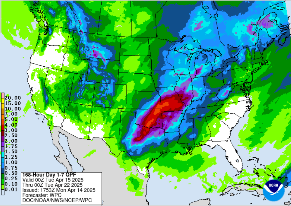
wxman22 wrote:The conservative NBM model has a nice signal for rain in North Texas and Oklahoma. The EPS look nice also. It's starting to look like there will be opportunities for severe weather Friday-Sunday. I am watching next Easter Sunday closely. It's far out but models are showing a pretty robust setup that day. Something to watch as we get closer in range.

https://i.ibb.co/BHrr0Ppk/qpf-acc-imp-us-sc.png

https://i.ibb.co/JR0MsCTc/qpf-acc-mean-imp-us-sc.png


If I'm not mistaken, NBM is a composite model of the various global models and their ensembles.
1 likes   

User avatar
wxman22
Category 5
Category 5
Posts: 1492
Joined: Mon Jan 30, 2006 12:39 am
Location: Wichita Falls, TX
Contact:

Re: Texas Spring 2025

#665 Postby wxman22 » Mon Apr 14, 2025 1:18 pm

(Today's NBM) A very good signal for heavy rainfall showing up.Especially since this is a blend.

Image
2 likes   

User avatar
Iceresistance
Category 5
Category 5
Posts: 9288
Age: 21
Joined: Sat Oct 10, 2020 9:45 am
Location: Tecumseh, OK/Norman, OK

Re: Texas Spring 2025

#666 Postby Iceresistance » Mon Apr 14, 2025 3:42 pm

2 likes   
Bill 2015 & Beta 2020

Winter 2020-2021 :cold:

All observations are in Tecumseh, OK unless otherwise noted.

Winter posts are focused mainly for Oklahoma & Texas.

Take any of my forecasts with a grain of salt, refer to the NWS, SPC, and NHC for official information

Never say Never with weather! Because ANYTHING is possible!

Stratton23
Category 5
Category 5
Posts: 2520
Joined: Fri Jul 21, 2023 10:59 pm
Location: Katy, Tx

Re: Texas Spring 2025

#667 Postby Stratton23 » Mon Apr 14, 2025 4:09 pm

All those models need to shift south by 300-500 miles, id prefer not to get donut holed lol
1 likes   

User avatar
South Texas Storms
Professional-Met
Professional-Met
Posts: 4226
Joined: Thu Jun 24, 2010 12:28 am
Location: Houston, TX

Re: Texas Spring 2025

#668 Postby South Texas Storms » Mon Apr 14, 2025 4:11 pm

The first in a series of disturbances should mainly impact north TX this weekend. Rain chances are then forecast to expand southward next week.
2 likes   

User avatar
Edwards Limestone
S2K Supporter
S2K Supporter
Posts: 476
Age: 36
Joined: Tue Dec 28, 2021 11:05 am
Location: Smithson Valley, TX

Re: Texas Spring 2025

#669 Postby Edwards Limestone » Mon Apr 14, 2025 4:42 pm

Same as every year now, NTX and OK get their seasonal rainfall while we get 1-2 minor events down south and stay in perpetual drought (with the exception of the anomalous RGV rain bomb earlier this season).

Frustrating for us, but not surprising.
0 likes   
The above post is NOT an official forecast and should not be used as such. It is just the opinion of the poster and may or may not be backed by sound meteorological data. It is NOT endorsed by any professional institution including Storm2k. For official information, please refer to NWS products.

snownado
Category 2
Category 2
Posts: 786
Joined: Sat Dec 09, 2023 7:00 pm
Location: Plano, TX

Re: Texas Spring 2025

#670 Postby snownado » Mon Apr 14, 2025 5:45 pm

DFW overachieved by a few degrees with a high of 88*F today.
0 likes   

TomballEd
Category 2
Category 2
Posts: 699
Age: 61
Joined: Wed Aug 16, 2023 4:52 pm
Location: Spring/Klein area, not Tomball

Re: Texas Spring 2025

#671 Postby TomballEd » Tue Apr 15, 2025 7:44 am

I don't have a way to link images from the school (they block imgur, Giphy and Discord) but I'm finally feeling a little better, all three major ensembles show greater than 1 inch of rain down to the I-10 corridor, and some spots may get 2 inches or more. 4 inches a month average seems a good number to prevent fires and keep lawn watering to a beginning, or 2 inches every two weeks would work.

Much more rain than that Oklahoma and North Texas but it looks spread out enough it probably doesn't flood outside of localized areas that see heavier cells or training.

3 days of 15% severe probs for parts of Texas and Oklahoma.
0 likes   

User avatar
txtwister78
Category 5
Category 5
Posts: 1855
Joined: Wed Jan 30, 2019 12:56 pm
Location: San Antonio

Re: Texas Spring 2025

#672 Postby txtwister78 » Tue Apr 15, 2025 1:59 pm

Edwards Limestone wrote:Same as every year now, NTX and OK get their seasonal rainfall while we get 1-2 minor events down south and stay in perpetual drought (with the exception of the anomalous RGV rain bomb earlier this season).

Frustrating for us, but not surprising.


Got to give this a little more time to play out before throwing in the towel. Models have already shifted a little SE for the weekend and continue to look a bit more promising the following week. I think we're in better shape with this upcoming pattern shift in general than you might think.

Too early to pinpoint specifics obviously but at least we've got something to track here having gone the last 10 days or so without anything.
2 likes   

User avatar
South Texas Storms
Professional-Met
Professional-Met
Posts: 4226
Joined: Thu Jun 24, 2010 12:28 am
Location: Houston, TX

Re: Texas Spring 2025

#673 Postby South Texas Storms » Tue Apr 15, 2025 3:48 pm

txtwister78 wrote:
Edwards Limestone wrote:Same as every year now, NTX and OK get their seasonal rainfall while we get 1-2 minor events down south and stay in perpetual drought (with the exception of the anomalous RGV rain bomb earlier this season).

Frustrating for us, but not surprising.


Got to give this a little more time to play out before throwing in the towel. Models have already shifted a little SE for the weekend and continue to look a bit more promising the following week. I think we're in better shape with this upcoming pattern shift in general than you might think.

Too early to pinpoint specifics obviously but at least we've got something to track here having gone the last 10 days or so without anything.


Yep I continue to be optimistic that we could possibly see a prolonged wet weather pattern beginning this weekend. There are signs in the latest longer range models that unsettled conditions could potentially last a few weeks too, which would be very beneficial for a large part of the state. Just hope the storms don't get too rowdy at times.
1 likes   

User avatar
wxman22
Category 5
Category 5
Posts: 1492
Joined: Mon Jan 30, 2006 12:39 am
Location: Wichita Falls, TX
Contact:

Re: Texas Spring 2025

#674 Postby wxman22 » Tue Apr 15, 2025 6:54 pm

Yes, the pattern looks very good for widespread rains for the state going into May. It also looks like the start of MCS season, buckle up its about to get busy lol. :)
0 likes   

Stratton23
Category 5
Category 5
Posts: 2520
Joined: Fri Jul 21, 2023 10:59 pm
Location: Katy, Tx

Re: Texas Spring 2025

#675 Postby Stratton23 » Wed Apr 16, 2025 12:52 am

Looks like the GFS/ Euro show a frontal boundary associated with the easter day system, potentially stalling out over central and se texas all of next week, with daily rounds of storms, heavy rain could be a possibility for areas further south
0 likes   

TomballEd
Category 2
Category 2
Posts: 699
Age: 61
Joined: Wed Aug 16, 2023 4:52 pm
Location: Spring/Klein area, not Tomball

Re: Texas Spring 2025

#676 Postby TomballEd » Wed Apr 16, 2025 1:02 pm

GFS and ensembles show weekend front is progressive and areas S of I-10 is skunked. Hour 360 GFS shows rather sharp boundary between 2 inches of more of rain and less than half an inch of rain. GFS ensemble at 300 hours agrees. Op Canadian a little more optimistic for Tuesday but I think the same cap wins for STX.
0 likes   

snownado
Category 2
Category 2
Posts: 786
Joined: Sat Dec 09, 2023 7:00 pm
Location: Plano, TX

Re: Texas Spring 2025

#677 Postby snownado » Wed Apr 16, 2025 1:10 pm

TomballEd wrote:GFS and ensembles show weekend front is progressive and areas S of I-10 is skunked. Hour 360 GFS shows rather sharp boundary between 2 inches of more of rain and less than half an inch of rain. GFS ensemble at 300 hours agrees. Op Canadian a little more optimistic for Tuesday but I think the same cap wins for STX.


It's also look less impressive in general for N. TX and OK, both from a QPF and severe weather standpoint.
0 likes   

rwfromkansas
Category 5
Category 5
Posts: 2627
Joined: Sat Aug 27, 2005 12:47 am
Location: North Fort Worth

Re: Texas Spring 2025

#678 Postby rwfromkansas » Wed Apr 16, 2025 3:05 pm

snownado wrote:
TomballEd wrote:GFS and ensembles show weekend front is progressive and areas S of I-10 is skunked. Hour 360 GFS shows rather sharp boundary between 2 inches of more of rain and less than half an inch of rain. GFS ensemble at 300 hours agrees. Op Canadian a little more optimistic for Tuesday but I think the same cap wins for STX.


It's also look less impressive in general for N. TX and OK, both from a QPF and severe weather standpoint.


Here we go again. Almost a joke at this point.
1 likes   

snownado
Category 2
Category 2
Posts: 786
Joined: Sat Dec 09, 2023 7:00 pm
Location: Plano, TX

Re: Texas Spring 2025

#679 Postby snownado » Wed Apr 16, 2025 3:14 pm

rwfromkansas wrote:
snownado wrote:
TomballEd wrote:GFS and ensembles show weekend front is progressive and areas S of I-10 is skunked. Hour 360 GFS shows rather sharp boundary between 2 inches of more of rain and less than half an inch of rain. GFS ensemble at 300 hours agrees. Op Canadian a little more optimistic for Tuesday but I think the same cap wins for STX.


It's also look less impressive in general for N. TX and OK, both from a QPF and severe weather standpoint.


Here we go again. Almost a joke at this point.


It's still gonna rain, but it's increasingly looking like another pedestrian event.
0 likes   

User avatar
South Texas Storms
Professional-Met
Professional-Met
Posts: 4226
Joined: Thu Jun 24, 2010 12:28 am
Location: Houston, TX

Re: Texas Spring 2025

#680 Postby South Texas Storms » Wed Apr 16, 2025 3:55 pm

Way too early to get discouraged. This could be a prolonged wet pattern with several rounds of showers and thunderstorms possible over the next few weeks.
0 likes   


Return to “USA & Caribbean Weather”

Who is online

Users browsing this forum: No registered users and 27 guests