SIO: ERROL - Post-Tropical

Moderator: S2k Moderators

Message
Author
User avatar
Hurricane2022
Category 5
Category 5
Posts: 1496
Joined: Tue Aug 23, 2022 11:38 pm
Location: Araçatuba, Brazil

Re: SIO: ERROL - Severe Tropical Cyclone

#61 Postby Hurricane2022 » Wed Apr 16, 2025 6:32 am

"High-end" T7.5 :froze:
Image
2 likes   
Sorry for the bad English sometimes...!
For reliable and detailed information for any meteorological phenomenon, please consult the National Hurricane Center, Joint Typhoon Warning Center , or your local Meteo Center.

--------

Una cvm Christo, pro Christo, et in Christo. Sit nomen Domini benedictvm.

User avatar
kevin
Category 5
Category 5
Posts: 2554
Age: 26
Joined: Wed Aug 28, 2019 4:35 am

Re: SIO: ERROL - Severe Tropical Cyclone

#62 Postby kevin » Wed Apr 16, 2025 6:39 am

Current imagery of Errol on VIS/SWIR :double:

Image
2 likes   

User avatar
Hurricane2022
Category 5
Category 5
Posts: 1496
Joined: Tue Aug 23, 2022 11:38 pm
Location: Araçatuba, Brazil

Re: SIO: ERROL - Severe Tropical Cyclone

#63 Postby Hurricane2022 » Wed Apr 16, 2025 6:40 am

Hurricane2022 wrote:Per MW imagery, Errol really did a very brief ERC. I hope he can clear his new and beautiful eye before shear kicks in.
Image
1 likes   
Sorry for the bad English sometimes...!
For reliable and detailed information for any meteorological phenomenon, please consult the National Hurricane Center, Joint Typhoon Warning Center , or your local Meteo Center.

--------

Una cvm Christo, pro Christo, et in Christo. Sit nomen Domini benedictvm.

Subtrop
Category 2
Category 2
Posts: 654
Joined: Sun Feb 21, 2021 9:45 pm

Re: SIO: ERROL - Severe Tropical Cyclone

#64 Postby Subtrop » Wed Apr 16, 2025 7:30 am

TPXS10 PGTW 161220

A. TROPICAL CYCLONE 29S (ERROL)

B. 16/0130Z

C. 14.31S

D. 119.01E

E. ONE/GK2A

F. T6.5/6.5/D3.0/24HRS STT: S0.0/03HRS

G. IR/EIR

H. REMARKS: 01A/PBO EYE/ANMTN. WMG EYE SURROUNDED BY CMG YIELDS AN
E# OF 6.5. ADDED 1.0 EYE ADJUSTMENT FOR CMG, TO YIELD A DT OF 7.5.
MET YIELDS 5.0. PT YIELDS 5.5. DBO 12-HOUR CONSTRAINT. BROKE 18-
HOUR AND 24-HOUR CONSTRAINTS DUE TO RAPID INTENSIFICATION.

I. ADDITIONAL POSITIONS: NONE


NEVAREZ
0 likes   

User avatar
cycloneye
Admin
Admin
Posts: 143861
Age: 68
Joined: Thu Oct 10, 2002 10:54 am
Location: San Juan, Puerto Rico

Re: SIO: ERROL - Severe Tropical Cyclone

#65 Postby cycloneye » Wed Apr 16, 2025 8:04 am

Breaking news

12z Best Track up to 140kt and pressure down to 919 mbs.

29S ERROL 250416 1200 14.4S 118.9E SHEM 140 919
3 likes   
Visit the Caribbean-Central America Weather Thread where you can find at first post web cams,radars
and observations from Caribbean basin members Click Here

User avatar
kevin
Category 5
Category 5
Posts: 2554
Age: 26
Joined: Wed Aug 28, 2019 4:35 am

Re: SIO: ERROL - Severe Tropical Cyclone: Breaking News: 12z Best Track 140kt / 919mbs

#66 Postby kevin » Wed Apr 16, 2025 8:06 am

Different intensity estimates at this point.

ADT (CI#) = 6.1 / 945 mb / 117 kt
AiDT = 116 kt
DPRINT = 937 mb / 112 kt
DMINT = 943 mb / 108 kt
SATCON = 944 mb / 117 kt

However, since ADT still holds on to constraints and it's been very clear that Errol is undergoing ERI, I'd personally pick the raw T#.

ADT (rawT#) = 6.8 / 927 mb / 135 kt

Manual Dvorak with eye correction even results in DT 7.5.

WMG eye + eye adjustment = 7.5 / 906 mb / 155 kt

So we basically have an intensity estimate ranging from ~945mb/110kt to ~905mb/155kt. Difficult to say where Errol is now exactly. I'd personally go for the raw T# of ADT with perhaps a slight nudge upwards due to the DT 7.5 -> 920 mb / 140 kt.

Edit: I guess JTWC is thinking about the same, just saw cycloneye's message after posting this. It's now officially a cat 5.
2 likes   

User avatar
cycloneye
Admin
Admin
Posts: 143861
Age: 68
Joined: Thu Oct 10, 2002 10:54 am
Location: San Juan, Puerto Rico

Re: SIO: ERROL - Severe Tropical Cyclone: Breaking News: 12z Best Track 140kt / 919mbs

#67 Postby cycloneye » Wed Apr 16, 2025 8:14 am

Close to it's peak in intensity.

Image
2 likes   
Visit the Caribbean-Central America Weather Thread where you can find at first post web cams,radars
and observations from Caribbean basin members Click Here

User avatar
cycloneye
Admin
Admin
Posts: 143861
Age: 68
Joined: Thu Oct 10, 2002 10:54 am
Location: San Juan, Puerto Rico

Re: SIO: ERROL - Severe Tropical Cyclone: 12z Best Track 140kt / 919mbs

#68 Postby cycloneye » Wed Apr 16, 2025 9:01 am

REMARKS:
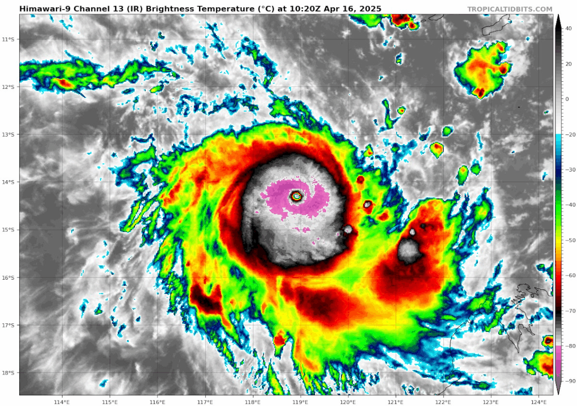
Severe Tropical Cyclone Errol has developed into a category 4 cyclone
displaying an eye. Position is based on animated EIR satellite imagery with
good confidence.

Intensity 95 kn based on a combination of intensity estimates.

Dvorak analysis. Dvorak analysis: DT is 6.5 based on eye pattern, W surrounding
and OW/WMG eye temp. Trend is D+ giving a MET of 4.5 and PT 5.0. FT and CI=5.5
are constrained. Objective estimates (1-minute average) at 1200UTC: ADT 117 kn,
AiDT 116 kn, DPRINT 112 kn, DMINT 108 kn and SATCON 117 kn.

Environmental conditions are favourable for further development over the next 6
to 12 hours. Sea surface temperatures are near 30C along the forecast track,
and deep layer moisture is in place around the system. Errol lies along the
axis of an upper-level anticyclone and CIMSS analysed deep layer wind shear is
about 10 kn from the northeast.

A shortwave upper trough over Western Australia is enhancing poleward outflow
and there is reasonable upper divergence analysed to the south of the
circulation. As a result further development is possible in the next 6 to12
hours. The upper trough is likely to increase vertical wind shear, thiswill
also be accompanied by dry air intrusion into the core and as a result Errol is
expected to weaken quickly during Thursday. Continued weakening is likely as
Errol approaches the west Kimberley coast on Saturday and it is possible the
system may have weakened below tropical cyclone intensity before crossing the
coast.

The system has become slow moving over the last 6 hours as the influence of a
mid-level ridge to the south weakens. An amplifying upper trough over southwest
WA is expected to steer the system southeast from Thursday, towards the west
Kimberley coast. The depth and intensity of Errol hasn't been captured fully by
the deterministic model runs. As a result, there is large uncertainty in its
movement along its track. On its current forecast, Errol is expected to make
landfall as a tropical low near Cape Leveque on Saturday afternoon. If Errol
weakens quickly then the low-level centre may be steered back to the west,
consequently there is still a large spread in location of the ensemble members
in the longer term.
1 likes   
Visit the Caribbean-Central America Weather Thread where you can find at first post web cams,radars
and observations from Caribbean basin members Click Here

User avatar
cycloneye
Admin
Admin
Posts: 143861
Age: 68
Joined: Thu Oct 10, 2002 10:54 am
Location: San Juan, Puerto Rico

Re: SPAC: INVEST 96P

#69 Postby cycloneye » Wed Apr 16, 2025 9:47 am


The second post of the thread by Hurricane2022 had ?????. It came close but it has put a great show in open waters without threatening any land.
1 likes   
Visit the Caribbean-Central America Weather Thread where you can find at first post web cams,radars
and observations from Caribbean basin members Click Here

User avatar
Hurricane2022
Category 5
Category 5
Posts: 1496
Joined: Tue Aug 23, 2022 11:38 pm
Location: Araçatuba, Brazil

Re: SIO: ERROL - Severe Tropical Cyclone

#70 Postby Hurricane2022 » Wed Apr 16, 2025 9:56 am

0 likes   
Sorry for the bad English sometimes...!
For reliable and detailed information for any meteorological phenomenon, please consult the National Hurricane Center, Joint Typhoon Warning Center , or your local Meteo Center.

--------

Una cvm Christo, pro Christo, et in Christo. Sit nomen Domini benedictvm.

User avatar
cycloneye
Admin
Admin
Posts: 143861
Age: 68
Joined: Thu Oct 10, 2002 10:54 am
Location: San Juan, Puerto Rico

Re: SIO: ERROL - Severe Tropical Cyclone

#71 Postby cycloneye » Wed Apr 16, 2025 10:09 am

1 likes   
Visit the Caribbean-Central America Weather Thread where you can find at first post web cams,radars
and observations from Caribbean basin members Click Here

Subtrop
Category 2
Category 2
Posts: 654
Joined: Sun Feb 21, 2021 9:45 pm

Re: SIO: ERROL - Severe Tropical Cyclone

#72 Postby Subtrop » Wed Apr 16, 2025 10:26 am

TPXS10 PGTW 161518
A. TROPICAL CYCLONE 29S (ERROL)
B. 16/1440Z
C. 14.47S
D. 118.92E
E. ONE/GK2A
F. T7.0/7.0/D3.5/24HRS STT: D0.5/03HRS
G. IR/EIR
H. REMARKS: 01A/PBO EYE/ANMTN. WMG EYE SURROUNDED BY W YIELDS AN E#
OF 6.0. ADDED 1.0 EYE ADJUSTMENT FOR CMG, TO YIELD A DT OF 7.0. MET
YIELDS 5.0. PT YIELDS 5.5. DBO DT. BROKE 18-HOUR AND 24-HOUR
CONSTRAINTS DUE TO RAPID DEVELOPMENT.
I. ADDITIONAL POSITIONS:
16/1039Z 14.30S 119.02E SSMS

NEVAREZ
1 likes   

User avatar
cycloneye
Admin
Admin
Posts: 143861
Age: 68
Joined: Thu Oct 10, 2002 10:54 am
Location: San Juan, Puerto Rico

Re: SIO: ERROL - Severe Tropical Cyclone

#73 Postby cycloneye » Wed Apr 16, 2025 10:33 am

1 likes   
Visit the Caribbean-Central America Weather Thread where you can find at first post web cams,radars
and observations from Caribbean basin members Click Here

MarioProtVI
Category 4
Category 4
Posts: 932
Age: 23
Joined: Sun Sep 29, 2019 7:33 pm
Location: New Jersey

Re: SIO: ERROL - Severe Tropical Cyclone

#74 Postby MarioProtVI » Wed Apr 16, 2025 10:35 am

So far this is the second storm this year that has absolutely exploded in intensity when I’m away for one day (had an exam yesterday…). Props to HAFS for nailing this even if it’s not the bonkers 865 mb run.
4 likes   

User avatar
Teban54
Category 5
Category 5
Posts: 3168
Joined: Sat May 19, 2018 1:19 pm

Re: SIO: ERROL - Severe Tropical Cyclone

#75 Postby Teban54 » Wed Apr 16, 2025 10:42 am

Image
1 likes   

User avatar
Yellow Evan
Professional-Met
Professional-Met
Posts: 16058
Age: 26
Joined: Fri Jul 15, 2011 12:48 pm
Location: Henderson, Nevada/Honolulu, HI
Contact:

Re: SIO: ERROL - Severe Tropical Cyclone

#76 Postby Yellow Evan » Wed Apr 16, 2025 11:38 am

Likely peaked at around 150 knots 3 hours ago. One of the most abrupt cases of rapid intensification I’ve seen with a pinhole to pinhole ERC that only took a couple hours right in the middle.
3 likes   

User avatar
Hurricane2022
Category 5
Category 5
Posts: 1496
Joined: Tue Aug 23, 2022 11:38 pm
Location: Araçatuba, Brazil

Re: SIO: ERROL - Severe Tropical Cyclone

#77 Postby Hurricane2022 » Wed Apr 16, 2025 11:46 am

2 likes   
Sorry for the bad English sometimes...!
For reliable and detailed information for any meteorological phenomenon, please consult the National Hurricane Center, Joint Typhoon Warning Center , or your local Meteo Center.

--------

Una cvm Christo, pro Christo, et in Christo. Sit nomen Domini benedictvm.

ChrisH-UK
Category 2
Category 2
Posts: 611
Joined: Sat May 29, 2021 8:22 am

Re: SIO: ERROL - Severe Tropical Cyclone

#78 Postby ChrisH-UK » Wed Apr 16, 2025 12:13 pm

The CIMSS real time intensity product had a peak speed of 138 knots. Well it has lived up to the HAFS-A hype for a change.

https://tropic.ssec.wisc.edu/real-time/ ... ry_IR.html

Image
0 likes   

ChrisH-UK
Category 2
Category 2
Posts: 611
Joined: Sat May 29, 2021 8:22 am

Re: SIO: ERROL - Severe Tropical Cyclone

#79 Postby ChrisH-UK » Wed Apr 16, 2025 12:25 pm

This is a 6 hour loop of Errol in the Tropical Airmass product. You can see its spinning away at peak speed being very tight and compact then it lets go of some of the mass, spreads out and slows down quite a bit.

KOMPSAT-2A Tropical Airmass

Image
2 likes   

User avatar
Hurricane2022
Category 5
Category 5
Posts: 1496
Joined: Tue Aug 23, 2022 11:38 pm
Location: Araçatuba, Brazil

Re: SIO: ERROL - Severe Tropical Cyclone

#80 Postby Hurricane2022 » Wed Apr 16, 2025 12:44 pm

1 likes   
Sorry for the bad English sometimes...!
For reliable and detailed information for any meteorological phenomenon, please consult the National Hurricane Center, Joint Typhoon Warning Center , or your local Meteo Center.

--------

Una cvm Christo, pro Christo, et in Christo. Sit nomen Domini benedictvm.


Return to “2025”

Who is online

Users browsing this forum: No registered users and 10 guests