
SIO: ERROL - Post-Tropical
Moderator: S2k Moderators
Re: SIO: ERROL - Severe Tropical Cyclone
1 likes
TC naming lists: retirements and intensity
Most aggressive Advisory #1's in North Atlantic (cr. kevin for starting the list)
Most aggressive Advisory #1's in North Atlantic (cr. kevin for starting the list)
-
Hurricane2022

- Category 5

- Posts: 2016
- Joined: Tue Aug 23, 2022 11:38 pm
- Location: Araçatuba, Brazil
Re: SIO: ERROL - Severe Tropical Cyclone
0 likes
Sorry for the bad English sometimes...!
For reliable and detailed information for any meteorological phenomenon, please consult the National Hurricane Center, Joint Typhoon Warning Center , or your local Meteo Center.
--------
ECCE OMNIA NOVA FACIAM (Ap 21,5).
For reliable and detailed information for any meteorological phenomenon, please consult the National Hurricane Center, Joint Typhoon Warning Center , or your local Meteo Center.
--------
ECCE OMNIA NOVA FACIAM (Ap 21,5).
-
Hurricane2022
- Category 5
- Posts: 2016
- Joined: Tue Aug 23, 2022 11:38 pm
- Location: Araçatuba, Brazil
Re: SIO: ERROL - Severe Tropical Cyclone
0 likes
Sorry for the bad English sometimes...!
For reliable and detailed information for any meteorological phenomenon, please consult the National Hurricane Center, Joint Typhoon Warning Center , or your local Meteo Center.
--------
ECCE OMNIA NOVA FACIAM (Ap 21,5).
For reliable and detailed information for any meteorological phenomenon, please consult the National Hurricane Center, Joint Typhoon Warning Center , or your local Meteo Center.
--------
ECCE OMNIA NOVA FACIAM (Ap 21,5).
-
cycloneye

- Admin

- Posts: 149275
- Age: 69
- Joined: Thu Oct 10, 2002 10:54 am
- Location: San Juan, Puerto Rico
Re: SIO: ERROL - Severe Tropical Cyclone
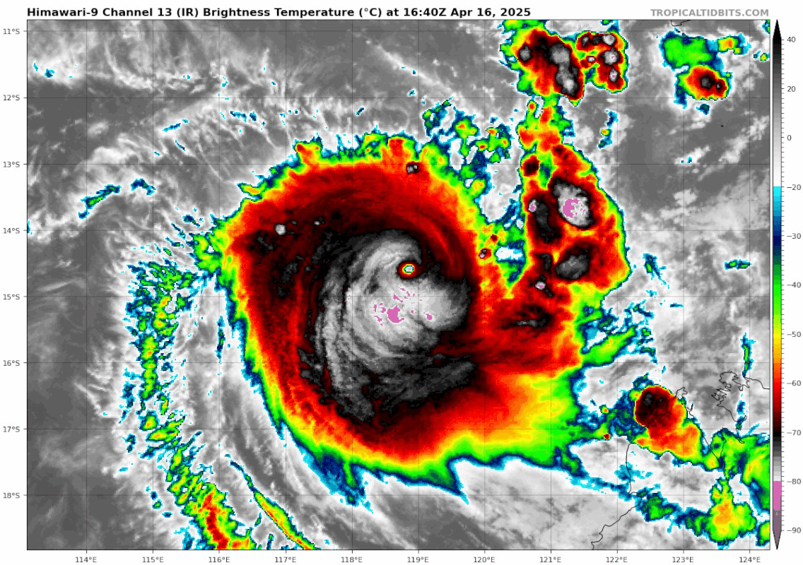
REMARKS:
Severe Tropical Cyclone Errol has weakened into a category 3 system.
The system was located using animated satellite imagery. There remains high
confidence of the position but it eye has become indistinct. The convection has
continued to weaken, with dry air wrapping around the western and northern
flanks of the system.
Intensity has been analysed as 85 kn based on Dvorak. DT based on an eye
pattern with W surrounding grey shade gives E-No of 6.0 and an Eye Adj of 1.0
due to W surrounding ring and CMG eye temp. This results in a DT of 5.0, but
due to the rapid weakening the final DT is 4.5, based off the 3 hourly average
DT. Trend is W giving a MET of 4.0 and PT 4.0. FT is 4.5 and CI held at 5.0
based on DT, but CI constraint due to the rapid weakening. Objective estimates
(1-minute average) at 0600UTC: ADT 99 kn, AiDT 92 kn, and DPRINT 100 kn.
Currently environmental conditions seem favourable however there are signs of
it beginning to degrade. Sea surface temperatures are near 30C along the
forecast track, and while deep layer moisture is in place over the system, mid
level dry air does appear to be affecting the western and northern flanks.
An upper trough to the southwest is providing strong outflow and at 0300 UTC
the CIMMS deep shear analysis shows Errol lying under 10-15 knots of northerly
shear. Shear is expected to increase further over the next 48 hours and will be
accompanied by a dry air intrusion into the core. As a result Errol is expected
to weaken quickly during the remainder of today and Friday as it approaches the
west Kimberley coast. Errol may cross the coast as a category 1 cyclone Friday
night, however it is expected to weaken quickly into a tropical low as it
crosses the coast.
Errol has started to move to the east southeast over the last 6 hours. The
upper trough over southwest WA is expected to continuing steering Errol towards
the west Kimberley coast. If Errol weakens quicker into a tropical low, then
the low-level centre may be steered back to the west, consequently there is
still a large spread in location of the ensemble members in the longer term.
0 likes
Visit the Caribbean-Central America Weather Thread where you can find at first post web cams,radars
and observations from Caribbean basin members Click Here
and observations from Caribbean basin members Click Here
-
cycloneye
- Admin
- Posts: 149275
- Age: 69
- Joined: Thu Oct 10, 2002 10:54 am
- Location: San Juan, Puerto Rico
Re: SIO: ERROL - Tropical Cyclone
REMARKS:
Tropical Cyclone Errol continues to weaken with no deep convection near the
estimated position of the low level centre.
Location is based on animated enhanced satellite imagery with poor confidence.
Deep cold convection has become sheared to the SE of the LLCC.
Dvorak analysis used shear pattern DT 2.5 to 3.0, acknowledging poor confidence
in the LLC and also a not strong gradient. MET is 4.5 with a W+ 24 hour trend,
PAT is 4.0. FT is 3.5 based on DT and PAT. CI is 4.0, held 0.5 higher.
Objective estimates (1-minute average) at 1800UTC: ADT 69 kn, AiDT 58 kn,
DPRINT 37 kn, DMINT 52 kn (1025 UTC) and SATCON 59kn (1530 UTC). Intensity set
to 55 knots.
Sea surface temperatures are near 30C along the forecast track. Water vapour
imagery shows mid-level dry air over and to the west of the low level centre.
An upper trough to the southwest is providing strong outflow and CIMMS deep
shear analysis shows Errol lying under 15 knots of north north-westerly shear.
Model guidance indicates stronger WNW winds in the mid-levels which has sheared
the system. Shear and dry air over the centre is expected to continue. As a
result, Errol is expected to continue weakening quickly to a category 1 cyclone
as it approaches the west Kimberley coast and crosses on Friday evening.
0 likes
Visit the Caribbean-Central America Weather Thread where you can find at first post web cams,radars
and observations from Caribbean basin members Click Here
and observations from Caribbean basin members Click Here
-
cycloneye
- Admin
- Posts: 149275
- Age: 69
- Joined: Thu Oct 10, 2002 10:54 am
- Location: San Juan, Puerto Rico
Re: SIO: ERROL - Post-Tropical
The last warning.
Intensity: Tropical Low, sustained winds near the centre of 65 kilometres per hour with wind gusts to 95 kilometres per hour.
Location: within 45 kilometres of 15.8 degrees South 124.4 degrees East, estimated to be 35 kilometres south southwest of Kuri Bay and 185 kilometres north northeast of Derby.
Movement: east southeast at 20 kilometres per hour.
Ex-Tropical Cyclone Errol has weakened below tropical cyclone intensity and is moving east southeast. It crossed the coast just south of Kuri Bay and is expected to move into the inland central Kimberley during Saturday.
0 likes
Visit the Caribbean-Central America Weather Thread where you can find at first post web cams,radars
and observations from Caribbean basin members Click Here
and observations from Caribbean basin members Click Here
Who is online
Users browsing this forum: No registered users and 167 guests