Texas Spring 2025

U.S. & Caribbean Weather Discussions and Severe Weather Events

Moderator: S2k Moderators

Forum rules

The posts in this forum are NOT official forecast and should not be used as such. They are just the opinion of the poster and may or may not be backed by sound meteorological data. They are NOT endorsed by any professional institution or STORM2K.

Help Support Storm2K
Message
Author
User avatar
Ntxw
Storm2k Moderator
Storm2k Moderator
Posts: 22730
Joined: Wed Oct 21, 2009 6:34 pm
Location: DFW, Texas

Re: Texas Spring 2025

#921 Postby Ntxw » Wed Apr 30, 2025 1:05 pm

HockeyTx82 wrote:
Ntxw wrote:1.92" and a southern batch coming through probably over 2" for the airport today.


What's the record for the day?


1.85" from 1905.
0 likes   
The above post and any post by Ntxw is NOT an official forecast and should not be used as such. It is just the opinion of the poster and may or may not be backed by sound meteorological data. It is NOT endorsed by any professional institution including Storm2k. For official information, please refer to NWS products.

  Help support Storm2K!
Help Support Storm2K

User avatar
wxman22
Category 5
Category 5
Posts: 1326
Joined: Mon Jan 30, 2006 12:39 am
Location: Wichita Falls, TX
Contact:

Re: Texas Spring 2025

#922 Postby wxman22 » Wed Apr 30, 2025 1:08 pm

Wonderful! Love to see the heavy rainfall amounts over DFW. For the southern half of the state your turn may be coming soon… Also more severe weather potentially tomorrow. Main threat is large hail.

Image

Image

Image
Last edited by wxman22 on Wed Apr 30, 2025 1:22 pm, edited 1 time in total.
1 likes   

rwfromkansas
Category 5
Category 5
Posts: 2529
Joined: Sat Aug 27, 2005 12:47 am
Location: North Fort Worth

Re: Texas Spring 2025

#923 Postby rwfromkansas » Wed Apr 30, 2025 1:21 pm

Ended with 3.17. Impressive. Might add some to this maybe.
2 likes   

User avatar
Edwards Limestone
S2K Supporter
S2K Supporter
Posts: 455
Age: 35
Joined: Tue Dec 28, 2021 11:05 am
Location: Smithson Valley, TX

Re: Texas Spring 2025

#924 Postby Edwards Limestone » Wed Apr 30, 2025 2:39 pm

Hate to be the resident debbie downer but the HRRR doesn't look good for the Hill Country through Friday. Some relief for other parts of south TX and SETX though.

Image
0 likes   
The above post is NOT an official forecast and should not be used as such. It is just the opinion of the poster and may or may not be backed by sound meteorological data. It is NOT endorsed by any professional institution including Storm2k. For official information, please refer to NWS products.

User avatar
South Texas Storms
Professional-Met
Professional-Met
Posts: 4197
Joined: Thu Jun 24, 2010 12:28 am
Location: Houston, TX

Re: Texas Spring 2025

#925 Postby South Texas Storms » Wed Apr 30, 2025 2:50 pm

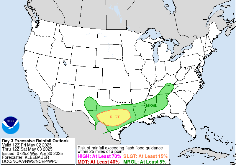
Edwards Limestone wrote:Hate to be the resident debbie downer but the HRRR doesn't look good for the Hill Country through Friday. Some relief for other parts of south TX and SETX though.

https://www.tropicaltidbits.com/analysis/models/hrrr/2025043018/hrrr_apcpn_scus_34.png


Tonight's activity will likely be mainly east of Austin and tomorrow mainly south of SA. The Friday event should mainly be late in the day and the HRRR doesnt go out that far yet.
1 likes   

TomballEd
Category 2
Category 2
Posts: 577
Age: 61
Joined: Wed Aug 16, 2023 4:52 pm
Location: Spring/Klein area, not Tomball

Re: Texas Spring 2025

#926 Postby TomballEd » Wed Apr 30, 2025 3:12 pm

I like HRRR. Storms are weakening below severe limits as they approach in the early morning, many areas get rain without lightning and thunder, always appreciated at that time of the day. A quarter inch or maybe a tad below average in Harris County, a few screw zones, but a few lucky people getting over three quarters of an inch.

Keeping an eye on the storms E of I-35 between AUS and ACT. IN the tornado watch, HRRR STPS above 5 in spots in the area.
1 likes   

User avatar
Ntxw
Storm2k Moderator
Storm2k Moderator
Posts: 22730
Joined: Wed Oct 21, 2009 6:34 pm
Location: DFW, Texas

Re: Texas Spring 2025

#927 Postby Ntxw » Wed Apr 30, 2025 3:24 pm

Luckily so far the tornado threat east of here hasn't panned. Storm mode has been mcs with cold pool.
3 likes   
The above post and any post by Ntxw is NOT an official forecast and should not be used as such. It is just the opinion of the poster and may or may not be backed by sound meteorological data. It is NOT endorsed by any professional institution including Storm2k. For official information, please refer to NWS products.


  Help support Storm2K!

Help Support Storm2K


User avatar
Texas Snowman
Storm2k Moderator
Storm2k Moderator
Posts: 6151
Joined: Fri Jan 25, 2008 11:29 am
Location: Denison, Texas

Re: Texas Spring 2025

#928 Postby Texas Snowman » Wed Apr 30, 2025 4:53 pm

Meteorologist Chris Nunley on Facebook: “ DEVELOPING: A temporary patch to the Lake Waxhoma Dam [Osage County, Oklahoma] completed back in May of 2021 has failed. Water is now pouring through and underneath the damaged section of the spillway which could lead to unpredictable downstream flooding. If you live downstream of the dam, stay alert to the latest and listen to all orders from local officials if issued. As of 4:00PM Wednesday, the Barnsdall Mayor says no one is currently in danger.”
0 likes   
The above post and any post by Texas Snowman is NOT an official forecast and should not be used as such. It is just the opinion of the poster and may or may not be backed by sound meteorological data. It is NOT endorsed by any professional institution including storm2k.org. For official information, please refer to NWS products.

User avatar
Texas Snowman
Storm2k Moderator
Storm2k Moderator
Posts: 6151
Joined: Fri Jan 25, 2008 11:29 am
Location: Denison, Texas

Re: Texas Spring 2025

#929 Postby Texas Snowman » Wed Apr 30, 2025 4:55 pm

Rainy month in Oklahoma for sure…

 https://x.com/okmesonet/status/1917644973391982996


2 likes   
The above post and any post by Texas Snowman is NOT an official forecast and should not be used as such. It is just the opinion of the poster and may or may not be backed by sound meteorological data. It is NOT endorsed by any professional institution including storm2k.org. For official information, please refer to NWS products.

TomballEd
Category 2
Category 2
Posts: 577
Age: 61
Joined: Wed Aug 16, 2023 4:52 pm
Location: Spring/Klein area, not Tomball

Re: Texas Spring 2025

#930 Postby TomballEd » Wed Apr 30, 2025 5:49 pm

evere Weather Statement
National Weather Service Austin/San Antonio TX
535 PM CDT Wed Apr 30 2025

TXC013-302300-
/O.CON.KEWX.SV.W.0060.000000T0000Z-250430T2300Z/
Atascosa TX-
535 PM CDT Wed Apr 30 2025

...A SEVERE THUNDERSTORM WARNING REMAINS IN EFFECT UNTIL 600 PM CDT
FOR CENTRAL ATASCOSA COUNTY...

At 535 PM CDT, a severe thunderstorm was located over Pleasanton,
moving northeast at 30 mph.

HAZARD...Golf ball size hail and 60 mph wind gusts.

SOURCE...Radar indicated.

IMPACT...People and animals outdoors will be injured. Expect hail
damage to roofs, siding, windows, and vehicles. Expect wind
damage to roofs, siding, and trees.

This severe storm will be near...
Pleasanton around 540 PM CDT.
0 likes   

User avatar
txtwister78
Category 5
Category 5
Posts: 1753
Joined: Wed Jan 30, 2019 12:56 pm
Location: San Antonio

Re: Texas Spring 2025

#931 Postby txtwister78 » Wed Apr 30, 2025 5:50 pm

Storm has developed just south of SA near Pleasanton and another trying to go up in south Bexar County. Big hail in progress already.
0 likes   

User avatar
wxman22
Category 5
Category 5
Posts: 1326
Joined: Mon Jan 30, 2006 12:39 am
Location: Wichita Falls, TX
Contact:

Re: Texas Spring 2025

#932 Postby wxman22 » Wed Apr 30, 2025 6:35 pm

Well the rainfall record has been officially broken in WF. It's now the wettest April on record with 10.32 inches of rain. :)
1 likes   

User avatar
Iceresistance
Category 5
Category 5
Posts: 9279
Age: 21
Joined: Sat Oct 10, 2020 9:45 am
Location: Tecumseh, OK/Norman, OK

Re: Texas Spring 2025

#933 Postby Iceresistance » Wed Apr 30, 2025 9:15 pm

wxman22 wrote:Well the rainfall record has been officially broken in WF. It's now the wettest April on record with 10.32 inches of rain. :)

OKC's record also fell as well, I forgot how much, but it is just under a foot.
1 likes   
Bill 2015 & Beta 2020

Winter 2020-2021 :cold:

All observations are in Tecumseh, OK unless otherwise noted.

Winter posts are focused mainly for Oklahoma & Texas.

Take any of my forecasts with a grain of salt, refer to the NWS, SPC, and NHC for official information

Never say Never with weather! Because ANYTHING is possible!

User avatar
Cpv17
Category 5
Category 5
Posts: 4914
Joined: Wed Dec 07, 2016 2:24 pm
Location: Wharton/El Campo, TX

Re: Texas Spring 2025

#934 Postby Cpv17 » Wed Apr 30, 2025 9:35 pm

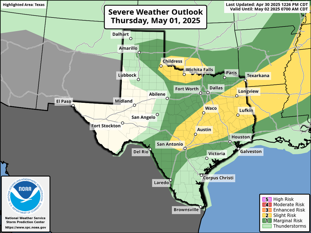
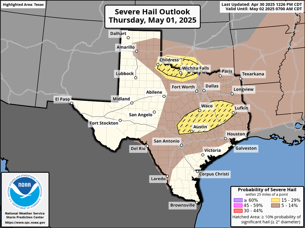
txtwister78 wrote:Storm has developed just south of SA near Pleasanton and another trying to go up in south Bexar County. Big hail in progress already.


Well that didn’t last very long. Tennis ball size hail at one point though.
0 likes   

User avatar
JDawg512
Category 5
Category 5
Posts: 1074
Age: 45
Joined: Mon Aug 26, 2013 8:56 pm
Location: Austin
Contact:

Re: Texas Spring 2025

#935 Postby JDawg512 » Wed Apr 30, 2025 10:49 pm

Can't seem to get anything to happen over Travis County. Specially the southside... It's very frustrating.
0 likes   
Resident Rain Miser

I am a weather hobbyist living 3.5 miles south of Downtown Austin and in no way or fashion should anything I say concerning forecasts be taken seriously. Please check your local NWS for accurate weather forecasting and conditions.

cstrunk
Category 2
Category 2
Posts: 610
Joined: Sat Jul 04, 2020 10:38 am
Location: Longview, TX

Re: Texas Spring 2025

#936 Postby cstrunk » Thu May 01, 2025 7:40 am

Quite the rain storm yesterday. 4.20" IMBY in Longview. Had a few dime size hailstones too.
2 likes   

TomballEd
Category 2
Category 2
Posts: 577
Age: 61
Joined: Wed Aug 16, 2023 4:52 pm
Location: Spring/Klein area, not Tomball

Re: Texas Spring 2025

#937 Postby TomballEd » Thu May 01, 2025 7:43 am

As is common around here, most of the Houston area missed significant rain yesterday and while 11Z HRRR shows a few strong storms well N of the Metro, nothing is immediate.

Pretty standard what looks like the promise of decent rains S of I-10 in Texas on the models evaporate as the events get closer. Even HRRR showed a decent, if weakening, line of storms through the HOU metro, which of course didn't materialize.
0 likes   

User avatar
Iceresistance
Category 5
Category 5
Posts: 9279
Age: 21
Joined: Sat Oct 10, 2020 9:45 am
Location: Tecumseh, OK/Norman, OK

Re: Texas Spring 2025

#938 Postby Iceresistance » Thu May 01, 2025 8:44 am


Link: https://youtu.be/tNE9o7gx49M

This was yesterday morning
2 likes   
Bill 2015 & Beta 2020

Winter 2020-2021 :cold:

All observations are in Tecumseh, OK unless otherwise noted.

Winter posts are focused mainly for Oklahoma & Texas.

Take any of my forecasts with a grain of salt, refer to the NWS, SPC, and NHC for official information

Never say Never with weather! Because ANYTHING is possible!

TomballEd
Category 2
Category 2
Posts: 577
Age: 61
Joined: Wed Aug 16, 2023 4:52 pm
Location: Spring/Klein area, not Tomball

Re: Texas Spring 2025

#939 Postby TomballEd » Thu May 01, 2025 9:13 am

12Z HRRR suggests some isolated supercells near I-35 between ACT and AUS.

STP is low, super cell composite is high and VIL suggests some hail. ~10 years ago forecast or actual VIL as a hail indicator was commonly used.
0 likes   

User avatar
txtwister78
Category 5
Category 5
Posts: 1753
Joined: Wed Jan 30, 2019 12:56 pm
Location: San Antonio

Re: Texas Spring 2025

#940 Postby txtwister78 » Thu May 01, 2025 9:54 am

12z hi-res models are a little more bullish on storms firing across SC TX today specifically late afternoon or early evening depending on the model of choice. Wouldn't be all that surprised to see an SPC upgrade today based on that with perhaps a larger significant hail threat designation.
2 likes   


Return to “USA & Caribbean Weather”

Who is online

Users browsing this forum: HockeyTx82, Iceresistance, Ntxw, Storm861 and 29 guests